Our Rides in Words, Photos & Videos

took a good test ride with the tandem running on both batteries. did 40 miles with about 10 miles left and we did 2500 feet of climbing most of it 7 to 10% with some steeper climbs it was a good workout.
Screenshot 2022-06-18 at 3.35.39 PM.jpg

IMG_0230.jpeg

when you have a lot of money so you can have horse statues.

IMG_0231.jpeg
IMG_0232.jpeg
IMG_0233.jpeg
IMG_0234.jpeg

no clue on this covered bridge like thing I dont think there is anything under it but ground.
IMG_0235.jpeg
IMG_0236.jpeg
IMG_0237.jpeg

nothing like a yard big enough to have a frisbee golf course along the river.

IMG_0238.jpeg
IMG_0240.jpeg

Now this is cool and mobile barbershop.
IMG_0241.jpeg
 
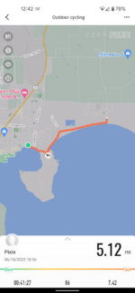
I was suckered by the five minutes of sun and got out. At least, the predicted rain did not happen. 15.5 miles and 800 feet of gain.

The same picture of folks enjoying low tide. One as shot and one edited on the phone using Google Pixel's Magic Eraser tool. Ah, one more edit since it was not my bike anyway, why not remove it, too.
PXL_20220618_215917396.jpg


PXL_20220618_215917396~2.jpg


PXL_20220618_215917396~3.jpg
 
I’m a few days behind in posting this trip report but editing the video footage took a bit longer than originally intended.

Two buddies of mine and I set out on a five-hour drive from home to Kimberley BC last Saturday with the intent of riding some singletracks in and around the local ski area. With rain in the forecast, we were hopeful of at least a couple days of reasonably good weather to make the trip a worthwhile endeavour. Even though our trip was cut short by a day or two, we still managed to fit in a stellar day of riding on a couple of great trails.

We were totally stoked on riding the Kimberley West Loop which includes 14 linked singles including two interconnecting loops.

https://www.trailforks.com/route/kimberly-west-loop/

Everything went according to plan until we were stymied by some serious deadfall on a secondary loop called RTM (Round the Mountain) Twist. According to Trailforks, RTM Twist is unsanctioned and word is that it continues to be a work in progress. We were forced to head back onto the main trail and continued on from there.

With so many intersecting trails and some not clearly marked we lost our bearings but were still able to complete the route albeit omitting one key loop (Magic Line) towards the end the route. We made it back to home base and rode it once we discovered where we screwed up.

Most of the West Loop was in superb condition and our hats off to the Kimberley Trails Society for maintaining this wonderful spot of paradise in the East Kootenays. Hope to make it back another time when the weather is slightly more cooperative.

Ride #1 - Kimberley West Loop

Web capture_15-6-2022_132313_www.strava.com.jpeg

Image-1 (002).jpg

The view from our digs.

GH010168_Moment.jpg


The start to the ride and surroundings were somewhat mundane but once we entered the forested sections along the RTM (Round The Mountain Trail) the scenery changed.

tree lined trail.jpg


There was plenty of opportunity to catch glimpses (albeit brief) of mountain backdrops every now and again. Most of the time I was too focused on the trail to notice what I was missing.

RndThe Mtn (brief view).jpg


Single Round The Mtn.jpg

GS010160_Round the mountain View.jpg

Much of the trails were rock strewn but the recent rains also kept the dust at bay. We were also a bit surprised at the little amount of mud we encountered along the way.

Rock Trail.jpg

Rocky Terrain.jpg

We came across this old cabin which apparently was built in the 1930s by locals as a shelter for XC skiers. The bugs were pretty nasty here so we didn’t hang around for very long.

Old Horsebarn.jpg

IMG_20220612_1243027.jpgIMG_20220612_1241566.jpg

You meet some of the nicest people along the trails. What a great spot for picnic!

Hikers.jpg


Shot of the boys. We would have stayed longer to enjoy the view but it was a tad short on space up there with a congregation of hikers and bikers.

IMG_20220612_1218253.jpg


Along the RTM Trail, there were a couple of intriguing rock slides to cross which required a bit of careful maneuvering.

Rock Slide (Kelvin).jpg


rockslide.jpg

first rock slide.jpg

We saw no signs of bears or posted warnings to speak of but that didn’t mean we came unprepared. Kelvin keeps his close by disguised his bottle cage.

Bear Spray.jpg

My clean pants were a sure sign that the ride was relatively mud free.

clean Pants.jpg

Footage of our first ride of the day along the Kimberley West Loop. It’s longer than what I usually bring to the table so be prepared with popcorn on hand or in @kahn ‘s case, supersize that bowl of cereal. ;)


Ride #2 - Magic Line

Our second ride wasn’t in the original plan but we knew that we couldn’t leave without completing the entire loop and finish up by riding Magic Line.

Web capture_15-6-2022_13262_ridewithgps.com.jpeg

Screenshot 2022-06-15 at 13-35-11 Garmin Connect.jpg
I’m glad that we did even though there were some tough climbs involved. The reward made for one entertaining downhill ride back to our base. Sweet!!

Magic Line Climb 2.jpg


Climb Magic Line.jpg

Final Climb.jpg


Magic Line Stay to the Right.jpg

IMG_20220612_1619088.jpg

Sublime!

Magic Line Corner View.jpg


The footage includes a special musical tribute to a favorite singer of mine. Can you guess who that might be?

 
I was suckered by the five minutes of sun and got out. At least, the predicted rain did not happen. 15.5 miles and 800 feet of gain.

The same picture of folks enjoying low tide. One as shot and one edited on the phone using Google Pixel's Magic Eraser tool. Ah, one more edit since it was not my bike anyway, why not remove it, too.
View attachment 126297

View attachment 126299


View attachment 126301
I got rained on for the last half mile home - karma for wishing for rain when I didn't think I would be able to ride 🤣!
 
Great weather today in Virginia even with the winds strong (though not like Rab's, mid-70s.. (23C?)). I took these garden pictures to send to a friend who's been bragging about his big garden. There were yellow squash on the ground, the size must approach half an acre...and there on the other side of his house are his grapevines. I'll include a few more pictures as the season, and his garden, mature. I wonder how many melons would fit in my trunk bag?
IMG_0913.JPG
I
 

Attachments

  • IMG_0914.JPG
    IMG_0914.JPG
    631.3 KB · Views: 133
  • IMG_0915.JPG
    IMG_0915.JPG
    1.1 MB · Views: 137
  • IMG_0916.JPG
    IMG_0916.JPG
    1.1 MB · Views: 124
@Mulezen - remind me to never brag about my gardens around you. That garden in your photos is jaw-dropping.

My friend, G, and I were out yesterday enjoying Virginia's beautiful weather as well. About an hour earlier I had picked up my LaFree from the bike shop. They had installed an entire new braking system - pads, rotors, and pistons - and I was anxious to try it out. No photos of the ride from me - I was too busy riding and conversing along our 12.5 mile gravel road route. We had intended a quick 8 miles around the block, but the cool, dry, clear weather was just too nice and we kept extending the ride. The roads were beautiful - hard and fast and recently graded to remove the potholes that were starting to sprout from the recent rains. The only downside was the wind. At one point we turned a corner on a road and were hit dead on by a gust that almost knocked G to the ground.

Minus the high winds, which we dodged for the most part by selecting the roads protected by trees and woodlands, the fabulous temps were a welcome respite from the recent heat and humidity that kept us indoors and close to the AC this past week. We have been promised the lovely cool weather will continue through Sunday's and Monday's rides before the mid-90+°f (33-34°c) heat slams us once again.
 
I did 19 miles today. I took a typical pic of what my area looks like. A barn covered in metal, was probably wood originally. There is an old windmill behind it and I expect there was a house at one time in the area that was long gone. I usually try to stick to paved roads but they are fixing some and I ended up riding 4 miles on gravel.
0BDDC076-9F88-4AF8-8A92-6E2648C3B424.jpeg
64036970-13DC-4F5E-8587-61BDE2D60C92.png
 
I did 19 miles today. I took a typical pic of what my area looks like. A barn covered in metal, was probably wood originally. There is an old windmill behind it and I expect there was a house at one time in the area that was long gone. I usually try to stick to paved roads but they are fixing some and I ended up riding 4 miles on gravel.
View attachment 126365View attachment 126366
Yep that's an old barn resided with metal. You can see the steel rail sticking out at the high point under the roof over hang. They used to stack loose hay in such barns. The steel rail ran the entire length of the barn and a pully system was driven by horses from out the back. They'd pull a wagon load of loose hay up to the front. A grappling device would grab a bunch of hay off the wagon, haul it up and into the large doors, which you can see the shadow of vaguely in your pic, and then drop the hay into the center of the large section of the barn. The lower section of the barn had a row of feeding troughs, mangers, for the animals and thru the winter they munched the whole big pile down to nothing. I watched my grandfather and uncles doing this in 1955 as a child. Probably the last time they ever did it as soon they bought a baler and a tractor and the horses became lovely anachronisms living their life out in ease in the pasture. I remember those horses, Nelly and Star, who to my five year old eyes were the size of elephants.
 
A Guided Tour Over A Mental Hospital

I have been totally swamped with my work for the last three-and-half days. This Sunday -- with the outside temperature of 33 C would be lost. However, I set off for a very short ride -- and told Facebook friends about it. The response of my friend Darek Howard was instant. When I was eating ice-cream at a Pruszków gas station, he drove his newly bought minivan up there. His Seat Alhambra can transport up to three bikes inside, so we immediately started planning our July rides. I need to mention Howard keeps my Lovelec e-bike and loves riding it!

So he drove home and I rode to his place (Vado SL). He produced my Lovelec and he took me for a tour over the Tworki Mental Hospital. The institution was created in 1891 in Tworki, now a quarter of Pruszków. He showed me so many interesting places there! It is good to be on a tour with a guide!

1655660423211.png

The Little Palace on River Utrata (so-called "The Patient Club"). I with my Vado SL, and Howard with my Lovelec. Howards starts talking buying the Lovelec from me! He said he got addicted to the e-bike!

1655660566564.png

In the past, the hospital was totally self-supported. The farm was feeding patients and the personnel. There was a school for nurses. There is a kindergarten. There is a church. And cemeteries, too. A big kitchen, a laundry. Nowadays, the hospital is sadly not self-supported anymore: the farm is idle.


A nice 20 km ride on the day I did not expect any ride at all!
 
Screenshot_20220619-145654.png

Now, that's better😁! Great to be out and about on our beautiful island again!

PXL_20220619_203057446.jpg

Passed by these guys, who had recently had a shave (but, apparently, not a hair cut)...

PXL_20220619_205058905.jpg

Obligatory bike shot 😁.

My friend who's joining me on the great Italian ebike tour in October is test riding bikes at our fabulous LBS on Tuesday (she does not yet have one), and I'll join her for that. We need to get busy "training" for the tour, so hope she finds something suitable quick!

Also looking for an app that will let me map/plan out local routes that will get us up to about 30 miles per ride (the average we'll be riding daily in Italy)... I've never done anything like this before so looking for suggestions 😁.
 
Caught up with the threads, but Im not replying to any because it all ends up at the end in a pile..so..
Youve all done very well...

Stinking hot Friday, town was rammed with tourists, I really think everyone has ditched work.
Its not a holiday resort here, theres no hotels, everyone arrives for the day and it was an incredible mix of schoolkids, nature lovers and party people.
But they love to collect together, I only have to ride 2 mins down the beach to get it all to myself.

I flew the drone right next to the manned warning hut at the MOD gun range, the flag was up, but the guy was totally disinterested in me and never looked up from his phone.
Screenshot_20220620-212625.png


So then I decided to try and ride down the bowl of the sand dune nearby, the lens flattens it out, but thats far too steep to walk up, it was terrifying, but a soft landing was guaranteed.
Screenshot_20220620-212710.png


Hovered the drone and cycled into view, still struggling, but Im getting there.
Screenshot_20220620-212828.png


Then it nearly went teets up, it went out of range so I did a return to home, for some bizarre reason it just shot up to 120m and started heading out to sea and I had no control.
To make it worse Im in a 60m height restrictions zone.
Turns out it was just heading to where it took off from and it landed safely.
Nice pic though.
Screenshot_20220620-213102.png


Sand was way too soft, I'd normally make that, but it just sucked all momentum and I just stepped off with the bike holding in place.
Screenshot_20220620-213133.png


Found something very odd and very dead, I'm guessing a small shark.

Screenshot_20220620-213216.png


Thats the Isle of Man jet powered Ferry, its a 90m trip from here to the Island and it does it in 2.45 hours.
Its been ferrying bikers there for the TT all last month
Screenshot_20220620-213201.png


My stats are..
sweaty.
terrified
panic.
sandy
oggling
well fed

In that order.


.
 
Riverside on the C&O Canal

The group ride yesterday - 25 miles on the National Park's C&O Canal between Point of Rocks, Maryland to Harper's Ferry, Maryland. A perfect morning with incredible weather, fabulous scenery on a freshly groomed historic canal path, and wonderful biking companions.

In pictures:
20220620_105039_copy_600x800.jpg

20220620_104832_copy_600x800.jpg


20220620_104848_copy_600x800.jpg

20220620_102334_copy_600x800.jpg

The river and terrain of Middle Proterozoic through Early Cambrian rocks (translate as: "very, very, very old rocks") is a geologist's dream come true.

20220620_104903_copy_600x800.jpg


20220620_092236_copy_600x800.jpg

20220620_092437_copy_600x800.jpg

A flood a year or so ago had washed out a critical high section of the old tow path that is still in the process of being rebuilt. This steep detour was fun if you ignored the sign like our leader did when he flew down the incline on his bike. The rest of us, who don't aspire to be flamboyant scofflaws, walked.

20220620_102049_copy_600x800.jpg

A small section of the 2,000+ mile long Appalachian Trail (hiking trail) that runs from Springer Mountain in Georgia (commonly known as the "deep south") to Katadin Mountain in Maine (northern tip of the US commonly known as "Down East"). We passed several hikers with backpacks bigger then they were, walking sticks in both hands, heads down watching the trail underfoot even though the terrain was picture perfect. I slowed to ask one hiker if he was a day hiker or a "through hiker". (Sometimes people are "in training" before they tackle the several months needed to hike the entire trail) He said he was a through hiker. "Heading north"? "Mt Katadin", he said with a smile. I wished him a wonderful journey and he thanked me as we both headed down the trail, me to finish out the 25 miles, and him to continue onwards another 1,000 miles. I admire those who are dedicated to a journey of that magnitude. At one time in my life - when I was 20 - I had hoped to be a through hiker on the trail. But those days of youth and dreams of walking 2,000 miles are now long gone, replaced by horses for distance riding, and now bikes replacing the horses to do the same.
Sometimes we can choose our paths, sometimes life and the advance of time chooses for us. No regrets, just enjoy what each day has to hold.
20220620_112000_copy_600x800.jpg

One of the many (long abandoned) locks along the historic canal, and the lock keepers houses, still carefully maintained as remnants of the past and our history of transportation.

The canal was a financial loss, it's profit quickly supplanted by an adjacent railroad that took all the business because it was faster and more reliable. The railroad still exists, the tracks elevated above the river on stunning escarpments (if that's the proper term?) of a variety of building material including carved stone blocks, concrete, rock rubble, and stacked railroad ties. Some of the stonework was an engineering marvel when one thinks about the labor involved to create a framework of stone, dirt, and rock, carved out of sheer rock cliffs, to support a functioning railroad for centuries.

The National Park Service Chesapeake and Ohio Canal
 

Attachments

  • 20220620_092437_copy_600x800.jpg
    20220620_092437_copy_600x800.jpg
    250.1 KB · Views: 127
Last edited:
Back