Prairie Dog
Well-Known Member
- Region
- Canada
- City
- Red Deer
Gorgeous. That lone red phone box against the rural backdrop tells it all.


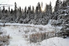
 If you are interested, there are two flavours of firefighting service in Poland. The Professionals are a state-run service and they are expected to fight fires in the first place. The Volunteers are present in any bigger village or a small town, and they are expected to assist the Professionals. Or, do daily chores expected from firefighters, such as removing a cat from a tree I was surprised to see Professionals there, as such activity would rather be in the Volunteers domain. If you pay attention, you will see the e-bike covered with frozen snow in several places. More rich casseroles are topped with, e.g., bacon, fungi, etc. Can save your life when you are starving on your winter ride!


Extraordinary, Peter! I've never seen anything like that before. And I enjoyed the photo galleries on your website. More please!Peter H post: 491423 said:Day Trips in the Countryside around Christchurch NZ
The video in the link below is of examples of my day trips and shows animated GPS traces, with popup photographs to illustrate the route and the varied landscape.
Peter
That path up the mountain, incredible, though my old manual legs would have buckled at the sight of itDay Trips in the Countryside around Christchurch NZ
In recent decades, like many cities around the world, Christchurch (NZ) has successfully constructed a major network of dedicated cycle paths and delineated cycle lanes. These have been a boon to the increasing numbers of both commuter and recreational cyclists.
In Christchurch, the substantial design and construction of the cycle infrastructure (ie no tokenism) is changing the mindset of people towards using this healthy and environmentally friendly form of transport. Cycling within the city has become safer. Besides, cycling is simply more fun!
As elsewhere, the development and availability of e-bikes have accelerated the trend in cycle use.
View attachment 109834
In addition to the intra-city cycle network the country districts around Christchurch now have a wide range of scenic cycle routes both dedicated and along “country lanes”. Exploring the local countryside by bike is one of my favorite activities. Pack a lunch and I’m off!
View attachment 109835
View attachment 109836
View attachment 109837
The video in the link below is of examples of my day trips and shows animated GPS traces, with popup photographs to illustrate the route and the varied landscape.
Chch Day Trips
Full screen mode on a display larger than on a mobile is recommended for viewing the video.
(If the above link to the video on a page on my personal site is inappropriate then please let me know ASAP and I will remove it.)
Cheers
Peter
My friend @Jerzy Bańkowski always says at such sights: "It's too crooked for me!"That path up the mountain, incredible, though my old manual legs would have buckled at the sight of it
I have shown Jerzy that photo of Peter and his comment was exactly as I have quoted! Aha, another pretext for a ride. Okay... let's ride for grocery shopping with a little detour to Brwinów petrol station Haha, I wouldn't drink that lager... Although it is as popular as Bud, Coors or Corona in the U.S. (Harnaś means: "A Tatra mountains highwayman"). Will do tomorrow!


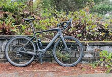
Gorgeous I'd video the sxxx out of thatnot a single ride, but two short and one long ride on the southern Oregon Coast. tagged along with some lifelong friends on a golf trip - i don’t golf but a round of golf takes around the same time as a nice long bike ride, and the refreshments and entertainment after are compatible!
View attachment 109849
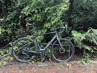
Ride 1: pouring rain, around 40-45f, mud, sticks, branches, pine needles, etc on the roads. my route included a short stretch of US-101, which has a shoulder suitable for bikes but unfortunately said shoulder was covered in some sort of very slimy, slippery bright green moss. in the wet conditions, i fell twice going in a straight line with nearly no traction whatsoever! Following that, i got off the big road for a serious of steep windy forest roads which had terrible paving conditions, huge potholes, totally covered in mud etc. a very challenging ride, which i cut short at about 28 miles, essentially as soon as i could figure out a safe way home! turned the creo’s motor on a few times on very steep sections, although the limited traction had me leery of any major efforts!
among the best of the road conditions!
View attachment 109854
a very dirty bike, but not as dirty as it had been before a downpour rinsed it off.
View attachment 109855
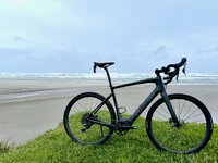
Ride 2: the weather cleared a bit, and i set off for a longer ride to the nearby coastal town of Coos Bay and back. A few of my selected roads turned out to be unpaved, so it wasn’t as much of a loop as i hoped. while the roads were still wet and dirty in spots, it was a beautiful day with changing skies, some sunlight, and even rainbows! total distance, 62.62 miles (a metric century!) and 4,429 feet of elevation in a bit under four hours. no battery usage at all - although there were rolling climbs, for the most part roads in this part of the world have been built with shallower grades than around San Francisco.
better conditions!
View attachment 109858
The Oregon coast, and rainbows!
View attachment 109859 View attachment 109860 View attachment 109861 View attachment 109862
Everything is so green!
View attachment 109863
Bridge over one of many Sloughs around Charleston and Coos Bay
View attachment 109864
Ride 3: an easy inland loop ride for a lovely morning. Unfortunately i misjudged the weather a bit, and although it was partly clear and not raining, i rode through a fast section of cold mist and found my hands very, very cold… going from cold to painfully cold to some mixture of numb and painfully cold. not much choice but to soldier on, but shifting and braking became clumsy, and when i arrived back at the hotel, I could not unclip my helmet for over 15 minutes. the normally easy act of squeezing the plastic clip was impossible - no matter how/what i tried my fingers could not generate the small force required! it was comical!
beautiful wetlands
View attachment 109866
chilly mist
View attachment 109867
all in all, an interesting couple days of riding.

Yes, it’s a Beef paste that can be used for cooking and to make a drink, similar to Vegemite or Marmite, (but these are Yeast based).I had to look up Bovril. It’s doesn’t sound good but maybe it’s like Veggimite(sp?), you have to develop a taste.