Our Rides in Words, Photos & Videos

My flat about six weeks ago was also a staple - easy to spot the reason for the flat. You have to figure the odds of a probably FLAT/prone oriented staple flipping its two legs up and embedding in a tire. Mine, too, was, of course, the rear. Had a heck of a time getting the tire off the rim and even more of a heck of a time getting it back on. Glad you had your concierge service along for the ride!
I got stapled also and I managed to break both of my tyre levers, luckily I was only a few miles from home and managed the walk of shame! I then purchased Schwalbe Marathon capable levers and one of these awesome tools which make tyre fitting very easy indeed!

 
Only you can answer that @David Berry , but there are over 700 more posts this year than the same time in 2020... and it can be slow to load.
We have many more ebike adventures ahead of us this year, but I wonder whether it might be time to ponder whether there really is a need for a new thread each year.
 
Concrete and Steel …

Brisbane Central seen from Kangaroo Point

Brisbane Central (a small part!)
Seen from right bank of Brisbane River
There's a lost tree in there – just to the left of the non-biodegradable builders' safety mesh – and next to it is the once-imposing edifice of the Customs Building with its copper dome now encrusted with its patina of verdigris.

Brisbane Customs House

Brisbane Customs House (Built 1880s)
Later in the ride…

Indooroopilly Riverwalk

Indooroopilly Riverwalk
Seen from left bank of Brisbane River
Seeing double? A new style of bridge? As is so often the case around the world, one bridge follows another. Closest to us is a 1920s suspension road bridge with concrete towers which, until 2010, had multi-storey apartments within. Furthest away is twenty-first century cycle and pedestrian suspension bridge. Between the suspension bridges are steel girder rail bridges (one rectangular, the other arched).

Below, the Indooroopilly Riverwalk is seen from the opposite direction (looking upstream). The photo was taken ten days ago when around thirty-five of us were on an Electric Bikes Brisbane shop ride. Lest there be any doubt: August was definitely winter!

Indooroopilly Riverwalk

Lat
 
Last edited by a moderator:
Concrete and Steel …

View attachment 99242
Brisbane Central (a small part!)
Seen from right bank of Brisbane River
There's a lost tree in there – just to the left of the non-biodegradable builders' safety mesh – and next to it is the once-imposing edifice of the Customs Building with its copper dome now encrusted with its patina of verdigris.

There's not much of a multi-use trail on ‘my’ side of the river. It'll come, and should look a bit like this…

View attachment 99243
Indooroopilly Riverwalk
Seen from left bank of Brisbane River
Seeing double? A new style of bridge? As is so often the case around the world, one bridge follows another. Closest to us is a 1920s suspension road bridge with concrete towers which, until 2010, had multi-storey apartments within. Furthest away is twenty-first century cycle and pedestrian suspension bridge. Between the suspension bridges are steel girder rail bridges (one rectangular, the other arched).

Below, the Indooroopilly Riverwalk is seen from the opposite direction (looking upstream). The photo was taken ten days ago when around thirty-five of us were on an Electric Bikes Brisbane shop ride. Lest there be any doubt: August was definitely winter!

View attachment 99244
Would never see the Greek style building to the left of the skyscraper and tree w/o knowing where to look, much less the copper dome.
 
I got stapled also and I managed to break both of my tyre levers, luckily I was only a few miles from home and managed the walk of shame! I then purchased Schwalbe Marathon capable levers and one of these awesome tools which make tyre fitting very easy indeed!

I did not know there were special levers for their Marathon!

And, I, too, got one of those "vise" clamps for the tire. Unfortunately, when I got a gash flat last week, I could not loosen the Through-axle so never got a chance to try the "vise" thingie. I called a friend for a bailout. I'm not sure that I could have ridden that tire again anyway.
I did loosen the through-axle using a rubber mallet!!!!!
 
The Best of Plans

It happened yesterday on a morning ride where I planned to do a 27 mile adventure, but was thwarted about 1/4 of the way into the ride by a two different limbs - the proverbial "arm and a leg" - who presented their strongly felt, unassailable case towards me abandoning my plan A for a lesser distance of 21 miles we shall refer here to as Plan A-. I won't even grace the alternate plan with any nomenclature because it just didn't warrant it. It was a well traveled route that I had taken many a time, and while beautiful and relaxing, it wasn't anything new. It was a same old same old.

Suffice to say I was a bit miffed not to do an adventure that morning, which is probably the reason why, as I was heading home, I stopped at a familiar street sign on a knoll announcing the entry to an undistinguished, roughly paved road which lay resting at the foot of the sign like a tired old dog. The carriages that had been driving on these roads this past weekend had taken this one road the other day on their own high tone adventures through many a beautiful estate. As I looked at the road sign, I happened to notice that there was also a state road number attached to it. For some strange reason I had always thought that this road was private. Probably because the august name it carried was that of an adjacent, very historic private estate. But apparently the road was not. Private, that is. In my 34 years of living in this area and knowing, and traveled, every road and path and ancient horse trail throughout the valley and the mountains, I had never ever thought to go down this road, let alone explore it. I just assumed it was a back fields entry to the estate that had given its name to the sign.

I noticed another sign, standing quietly just a little bit up that road, that mentioned in an offhand way that the road ended in 1.6 miles. Not that far, really, if I wanted to add a bit of a diversion to my A- route. I did suspect, which turned out to be accurately correct, that the badly paved start of the road, which was a short upwards hill meant to shield the ongoing road from view, would transition to gravel within a hundred feet or so. I didn't think my Vado would mind terribly a short little detour up that gravel road to see what it was all about.

The road jogged by a couple of tightly grouped houses that looked a bit down on their luck with absolutely no pretense for trying to present a decent face that showed that the inhabitants even cared for their domicile. One house looked barely livable, paint peeling on the wood siding, the yard over grown with grass among which random toys had been scattered, old tires placed in towering stacks, a broken down car propped up on cinderblocks, and an owner who was on his knees, struggling with a lawn mower that was presenting a stubborn willfulness not to start. The owner had his back to me so I pedaled on silently, not wishing to disturb his concentration.

The worn out houses, I was to discover, had been a ruse. A carefully crafted method to discourage anyone from venturing further down the road by making them believe there would be nothing to see except more derelict buildings and overgrown lawns full of trash.

The carriages must have known something, I thought, because they had continued on ... if the carriage wheel marks on the road were any indication. So I pressed on as well, rounding a turn to find myself abruptly enveloped by an open rural landscape that would have been right at home with the rattle of carriage wheels and hooves on the gravel. A plethora of autumn tickseed flowers sprang out of nowhere, crowding the roadside in a profusion of yellow daisy heads on shoulder high stems. The trees marched up to the road and arched their branches overhead, shading me from the sun as I pedaled on admiring the uncultivated fields that ebbed and flowed on either side of me. Every now and then an estate came into view, set with decorum far enough from the road to avoid any dust but close enough to show off the beautiful architecture of the house and attending barns.
20210906_115505_copy_750x1000.jpg


The gravel road beckoned me on, increasingly less and less civilized while continuing to promise wonderful views of a gentler time more in keeping with a life once measured by the pace of a horse and carriage. I had to watch the road more carefully now as it threw off the trappings of being "maintained" by becoming one with nature. There were several times the deep ruts and washouts caused me to hesitate and wonder if I should turn back and forget this adventure for another time...
20210906_114942_copy_750x1000.jpg


...until I rounded a rough and tumble bend and stopped to gaze at something I had never seen before. A tree, a full grown tree, perhaps 30 years or more old, growing right out of the top of an old silo. I looked up with my mouth open, staring for the longest time at this anomaly of abandonment. The silo had to be a century at least, while a old rusted pipe gate nearby had been closed many years ago with not a soul bothering to open it since.
20210906_113959_copy_612x816.jpg


The road, not content to leave me standing there with my jaw agape, continued to beckon me forward. At times it was a touch more groomed, a clear attempt to discourage me from turning back and to keep me moving forward to see what the next bend would uncover.

Soon enough another estate came into view. A young gal dressed in riding clothes was busy weedwacking into submission the tall grass at the entryway. She glanced up at me with a look of curiosity as if wondering where I had suddenly appeared from, then returned her attention to her weed whacker before I had a chance to wave hello. I guess my presence wasn't worth her time, so I shrugged and continued on.

The trees returned to the side of the road as the road itself continued until it made a metamorphosis from gravel road bed to private driveway. I knew I had come to the end when I reached a sign announcing that the state maintenance of the road would go no further. I stopped and looked a bit farther down the road where it diverged to become a two land farm path into the woods, guarded by a closed pipe gate that clearly indicated any further advance was forbidden. The carriages had gone that way, through the then opened gate as a welcome by the adjacent estate to continue. I, on the other hand, was not invited. The gate was shut now, so it was the end of the road for me with only one way out. The same way I had come in.
20210906_114606_copy_816x612.jpg


Still, I stood there for a few moments studying the countryside. I knew if I had been on my horse there would have been no question that I could have gone through that gate without a concern in the world, and travel the rest of the journey that would take me across another mile or two of farm field before I reached the main entryway of the big estate. Maybe one day I will do that. But it was not going to be today.
20210906_114629_copy_750x1000.jpg


I turned my bike around and traveled back down that ancient road, past the young gal still working her weed whacker, through the rough ditches left crisscrossing the road from the recent heavy rains, past the tree growing out of the old silo, and the fields of autumn flowers. I passed the man that was still trying to coax his recalcitrant lawn mower into life, his back still towards me. He never knew I had passed there and back again.

All too soon I was back on the main road again, back onto a modern road with modern views and vistas the rest of my way home. Those 3.2 miles had been a unique sketch of a time that had once been "now" long ago, a road filled with carriage wheel tracks and hoof prints intermingled with bits of modern life here and there including the track of my very modern bicycle.

It had been a worthy detour after all. Worthy enough to be called by a worthy name I thought as I cycled towards home. Plan B had made my day, that's for sure.
Screenshot_20210907_212806_copy_608x792.jpg
 
Last edited:
Concrete and Steel …

View attachment 99270
Brisbane Central (a small part!)
Seen from right bank of Brisbane River
There's a lost tree in there – just to the left of the non-biodegradable builders' safety mesh – and next to it is the once-imposing edifice of the Customs Building with its copper dome now encrusted with its patina of verdigris.

View attachment 99272
Brisbane Customs House (Built 1880s)
Later in the ride…

View attachment 99243
Indooroopilly Riverwalk
Seen from left bank of Brisbane River
Seeing double? A new style of bridge? As is so often the case around the world, one bridge follows another. Closest to us is a 1920s suspension road bridge with concrete towers which, until 2010, had multi-storey apartments within. Furthest away is twenty-first century cycle and pedestrian suspension bridge. Between the suspension bridges are steel girder rail bridges (one rectangular, the other arched).

Below, the Indooroopilly Riverwalk is seen from the opposite direction (looking upstream). The photo was taken ten days ago when around thirty-five of us were on an Electric Bikes Brisbane shop ride. Lest there be any doubt: August was definitely winter!

View attachment 99244
Lat
Patina of verdigris.
Copper rust I discovered :)
 
Alicia…
Welcome to the Electric Bike Review Forum, a place where ebikers swap yarns and help one another.

There are many threads on the EBR Forum but this is the one where we celebrate the pure joy of our ebike adventures. During these difficult times, few of us have ventured across our state or provincial boundaries, let alone visited another country. Stefan in Poland is one of the fortunate exceptions, and we hugely enjoy his tales!

Please share your adventures on this Our Rides in Words, Photos, Videos & Maps thread. You are guaranteed an appreciative audience.
…David
Thanks a lot for inviting me
 
I did not know there were special levers for their Marathon!

And, I, too, got one of those "vise" clamps for the tire. Unfortunately, when I got a gash flat last week, I could not loosen the Through-axle so never got a chance to try the "vise" thingie. I called a friend for a bailout. I'm not sure that I could have ridden that tire again anyway.
I did loosen the through-axle using a rubber mallet!!!!!
I bought these levers and I highly recommend them!

 
The Highwood Pass – Peter Lougheed Provincial Park

Web capture_7-9-2021_221554_ridewithgps.com.jpeg

Web capture_7-9-2021_222246_ridewithgps.jpg

IMG_20210907_1310518.jpg

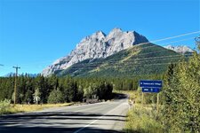
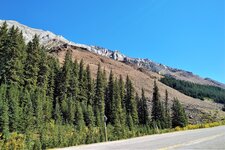
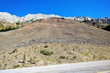
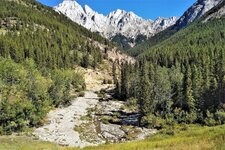
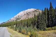
There was nothing but clear, blue skies yesterday morning which set up another epic ride in the mountains as my brother-in-law and I set out to cycle up the Highwood Pass which maintains the reputation as being the highest paved road in Canada. Neither of us was familiar with this section of the Kananaskis Trail so we didn’t know what to expect other than it was a steady uphill climb to get to the top and a relatively smooth downhill descent on the return leg back to our starting point. I felt relieved that I made the decision to leave the WTB Riddlers on the wheels from the previous outing as some portions of the side shoulders were quite brutal heading back down from the pass. The pass itself is closed to traffic from December to June 15th to protect the native wildlife.

Our starting point would be the Ribbon Creek Day Use Area. Located near the Nakiska Ski Resort (which played host to the 1988 Winter Olympic downhill), Ribbon Creek is a popular jumping off point for many avid hikers. My wife, who normally rides with us, decided instead to hike up to Ribbon Falls. She still managed to cover the entire 22km round trip even with a sore back.

IMG_20210907_0950351.jpg


Ribbon Creek. The trail to the falls is off in the distance.

IMG_20210907_1010229.jpg


View of Mount Kidd from Hwy 40

IMG_20210907_1019260.jpg

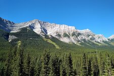
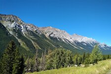
As usual, there was plenty of mountain scenery to admire along the way but not much else with the exception of the odd mountain ram or two blocking the middle of highway. The same two animals were quite content to stay put in their favorite spot upon our return back down from the pass.

GH010865_Moment.jpg

GH010872_Moment.jpg

Something you don’t see too often. A Dodge Ram meets its match.

IMG_20210907_1312510.jpg

My BIL stops for a moment to take in the view. There are times when the destination is the farthest thing from your mind and nothing else seems to matter but being in the present.

IMG_20210907_1158070.jpg


This turnoff is near the Fortress Junction about 20km from the start of the ride.

IMG_20210907_1206220.jpg


IMG_20210907_1207023.jpg

A winding section of the trail that was a sheer pleasure to ride.

IMG_20210907_1317189.jpg


Made it!! 👍

IMG_20210907_1338376.jpg


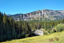
I took the opportunity to snap a couple of more pics on our way back.

IMG_20210907_1401329.jpg


IMG_20210907_1420093.jpg


A video tribute of our chug up to the Highwood Pass and Peter Lougheed Provincial Park


IMG_20210907_1217503.jpgIMG_20210907_1219455.jpgIMG_20210907_1224172.jpgIMG_20210907_1234282.jpgIMG_20210907_1328304.jpgIMG_20210907_1329182.jpgIMG_20210907_1426137.jpgIMG_20210907_1412152.jpg
 
Its a huge and beautiful place.
But bears...I mean I would be scanning the whole time.
I know youd never see one, but still.
Quite right especially in the fall when there is generally more feeding activity occuring. Bears are something one needs to be cognizant of even on a bike. We bring spray and air horns as a deterrent but even those won’t guarantee your safety. I do believe that we diminish our chances for an encounter while cycling on the roads compared to a hiker in the backcountry. That being said, as a precaution, we always check the weekly reports for any bear activity in the area where we plan to be in.

https://www.albertaparks.ca/parks/kananaskis/kananaskis-country/advisories-public-safety/

On this day, there were plenty of hikers at Ribbon Falls as well as up at the pass. I just hope that all of those folks were taking the same precautions and traveling in groups. One can never be too careful. That being said, most bear attacks happen when the animal feels threatened, is desperate for food, or have resulted when being surprised. I don’t feel we put ourselves at high risk when road cycling. MTB’ing in the back country might be a different kettle of fish altogether.
I guess those sheep were licking salt from the roadway? IDK
 
I guess those sheep were licking salt from the roadway? IDK
Yep. It’s behavioral thing. The sheep tend to migrate to the same spot once they become familiar with the salt spots along the roadway. One way to combat this and avoid the animals from being struck by vehicles might be to plant intercept salt licks in areas near the treeline so they don’t hang around the road. I’ve heard of this method working well on select highways in BC.
 
I set out to cycle up the Highwood Pass which maintains the reputation as being the highest paved road in Canada.
That was a serious climb! Was the ride on your Creo with a Range Extender? How did you fare with that? (Assistance level, battery consumption, etc). As I can see half of the distance was downhill (no assistance needed there, right?)
 
Back