Our Rides in Words, Photos & Videos

That was a serious climb! Was the ride on your Creo with a Range Extender? How did you fare with that? (Assistance level, battery consumption, etc). As I can see half of the distance was downhill (no assistance needed there, right?)
We both had REs, Stefan. At the end of the ride, my internal showed 49% remaining and 59% on the RE. Neither of us are big on keeping track of ride stats, in fact my BIL doesn’t even own a bike computer or have the MI app installed on his phone. I was predominantly on sport during the run up to the pass with the exception of some steeper sections where turbo assist was required. Downhill is a relative term. Yes, much of it was coasting but there were also stretches on the return leg that still required some effort and just the opposite could be said on the way up to the pass. Case in point, 4:19 on the video clearly shows us coasting down a short section of the highway at 46 km/hr and then resuming the climb shortly after.
 
Beautiful place they're riding at.
They are living the dream.
@Prairie Dog did you go there with an expedition vehicle with your bikes?
Yes, sometimes it feels like were living the dream but one could also say that about the Aloha state. It’s a 2 1/2 hour drive from my home town to Kananaskis Country and no special wheels are required to get there. K-Country is where I met my wife and so it’s always considered a special time when we re-visit the area.
 
Quite right especially in the fall when there is generally more feeding activity occuring. Bears are something one needs to be cognizant of even on a bike. We bring spray and air horns as a deterrent but even those won’t guarantee your safety. I do believe that we diminish our chances for an encounter while cycling on the roads compared to a hiker in the backcountry. That being said, as a precaution, we always check the weekly reports for any bear activity in the area where we plan to be in.

https://www.albertaparks.ca/parks/kananaskis/kananaskis-country/advisories-public-safety/

On this day, there were plenty of hikers at Ribbon Falls as well as up at the pass. I just hope that all of those folks were taking the same precautions and traveling in groups. One can never be too careful. That being said, most bear attacks happen when the animal feels threatened, is desperate for food, or have resulted when being surprised. I don’t feel we put ourselves at high risk when road cycling. MTB’ing in the back country might be a different kettle of fish altogether.
A bunch of us visited in 97.
We went to Harrison Springs for the hot pools.
There was a casual sign on the boardwalk.
A visiter had been killed by a bear.
The day before!!!!
His friend who who was merely mauled was on the news that night.
A helpful American ran to his car , got his gun and shot it.
 
Will winter ever come to an end? (Hope not.)

Moreton Bay Cycleway, Woody Point

Woody Point
Moreton Bay Cycleway
Nothing much to say about this ride.

I dare not cross the state border for the unforeseeable future. Drat: I'm stuck 'at home', forever pedalling the same route. Now I know how Sisyphus felt!

Queensland: beautiful one day, perfect the next.

Cabbage Tree Creek, Shorncliffe

Cabbabe Tree Creek
Next to Moreton Bay Cycleway
 
Last edited by a moderator:
A bunch of us visited in 97.
We went to Harrison Springs for the hot pools.
There was a casual sign on the boardwalk.
A visiter had been killed by a bear.
The day before!!!!
His friend who who was merely mauled was on the news that night.
A helpful American ran to his car , got his gun and shot it.
Actually, that incident occurred at Liard Hot Springs in northern BC. I remember clearly as we were driving up to the Yukon Territory to visit my sister and her husband in Whitehorse the year prior. We heard about the tragic news a year later and admittedly never thought about bears during the time when we relaxed at those same soothing springs. We even tented along the way as we drove further north into Alaska.
 
Actually, that incident occurred at Liard Hot Springs in northern BC. I remember clearly as we were driving up to the Yukon Territory to visit my sister and her husband in Whitehorse the year prior. We heard about the tragic news a year later and admittedly never thought about bears during the time when we relaxed at those same soothing springs. We even tented along the way as we drove further north into Alaska.
Yes it could have been..I think harrison was where we heard princess Di had died.
Got the Laird vist on film and the tv interview.
 
@Prairie Dog

Thank you so much for your ride photos and the video which allowed me to ride vicariously with you from 2,000+ miles away. Really stunningly beautiful scenery. Such a treat to see the vistas that others can enjoy. Thank you for sharing your ride with us.👍

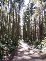
Wanted to ask if the pine forests were a planted effort - like those from the 1930's CCC in the US - or are they a non-orchestrated effort simply Nature on her own?
I would guess that in a Provincial park, the trees would probably be "old growth" therefore, natural as they are generally in our National Parks like Mt Rainier or in our wilderness areas like the Alpine Lakes Wilderness in WA state.

We do have our replanted forests and some trails in WA state traverse those, too. In some of those, you see incredibly large stumps and can even see the large notches that the lumberjacks created to stand in/on when sawing down those giant trees.
 
@Prairie Dog

Thank you so much for your ride photos and the video which allowed me to ride vicariously with you from 2,000+ miles away. Really stunningly beautiful scenery. Such a treat to see the vistas that others can enjoy. Thank you for sharing your ride with us.👍

Wanted to ask if the pine forests were a planted effort - like those from the 1930's CCC in the US - or are they a non-orchestrated effort simply Nature on her own?
Glad to know that you enjoyed the photos and video. Most of the evergreens are, as @kahn mentioned, old growth Lodgepole/Jack pine, spruce and subalpine fir. Unfortunately, the mountain pine beetle has had a drastic effect on the pine forests and it’s been a battle to keep them under control.

https://esrd.maps.arcgis.com/apps/Cascade/index.html?appid=b81dbef8d02344e6bb734087669626db

Our cold winters here do seem to have a moderate effect on the little critter's population but with warming trends continuing for the foreseeable future the MPB will likely be here to stay. :(
 
Prairie - too bad you have all that monotonous (or is it mountainous) scenery. You need to move somewhere more interesting!
If I continue this practice of posting mountainous shots, then it may very well become monotonous. ;) We still have a cycling trip up to Jasper in the works but like everything else, we must always contend with the prevailing weather conditions and an early snowfall is nothing unusual at this time of year in the mountain resorts.
 
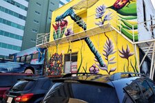
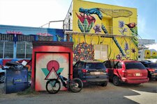
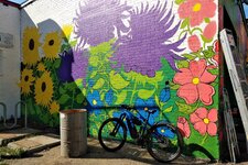
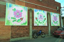
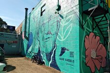
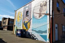
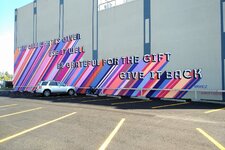
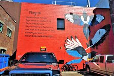
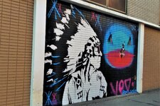
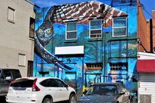
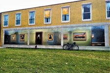
I was back on the bike today but with a different purpose in mind. I hit the trails today for a bit of a work out then popped into the downtown core to check out some of the recently commissioned murals meant to help beautify our city alleyways. Named Art Alley, the project was a collaboration between the city and the Downtown Business Association. I took a special interest in this as one of the buildings was once owned by my family.

IMG_20210909_1145515.jpg

IMG_20210909_1150240.jpg

IMG_20210909_1202004.jpg

IMG_20210909_1146366.jpgIMG_20210909_1146423.jpgIMG_20210909_1147161.jpgIMG_20210909_1148253.jpgIMG_20210909_1149241.jpgIMG_20210909_1151160.jpgIMG_20210909_1154127.jpgIMG_20210909_1158108.jpgIMG_20210909_1200347.jpgIMG_20210909_1202149.jpgIMG_20210909_1203109.jpgIMG_20210909_1203169.jpgIMG_20210909_1203248.jpgIMG_20210909_1639244.jpgIMG_20210909_1204502.jpg
 

Attachments

  • IMG_20210909_1204502.jpg
    IMG_20210909_1204502.jpg
    783.3 KB · Views: 215
Last edited:
Beautiful day for a little jaunt on central Whidbey Island! Starting in Coupeville, we headed south along the paved Rhododendron trail, which parallels the busy route 20 for a bit before diverging into Rhododendron county park. The tree-lined paved service road/walking path traverses the park and comes out into less-traveled rural roads on the opposite side: IMG_20210909_120034350_HDR.jpg

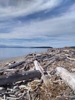
Continuing along, arrived at the western coast of the island, just south of the Keystone ferry landing. The stone beaches are littered with driftwood:
IMG_20210909_123026689_HDR.jpg

Continued past the ferry up into Fort Casey State Park for lunch. The fort was once one of a strategic triangle of 3 (two in Whidbey Island, and one across the Sound near Port Townsend, on the Olympic Peninsula) defending northern Puget Sound, but was decommissioned after WWI. You can see the old walls and gun emplacements across the parade ground, with the Olympic Mountains across the Sound:
IMG_20210909_125340442_HDR~2.jpg

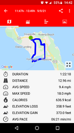
After a nice rest enjoying the view, we made our way back to Coupeville, completing a nearly 13-mile circuit:
Screenshot_20210909-144224.png
I did notice a slight rhythmic "bumping" in the rear tire - the one that had the flat and has two patches - near the end of the ride. Everything looks ok, but we'll have to figure out what's causing that sensation. The patches on the tube???


You are living the dream man!
There's an artist in Hawaii that paints on buildings with whales and sharks and turtles.
I haven't seen new art from him.
I like the Fox.
The murals certainly transform the alleys which were otherwise seeing quite a bit of negative activity. Thirteen artists from across Canada and as far away as the UK pooled their talents over the summer months to produce some truly visual work. Ryan Willert who painted ‘The Magpie’ is indigenous and is also from the local area.
 
Beautiful day for a little jaunt on central Whidbey Island! Starting in Coupeville, we headed south along the paved Rhododendron trail, which parallels the busy route 20 for a bit before diverging into Rhododendron county park. The tree-lined paved service road/walking path traverses the park and comes out into less-traveled rural roads on the opposite side: View attachment 99533

Continuing along, arrived at the western coast of the island, just south of the Keystone ferry landing. The stone beaches are littered with driftwood:
View attachment 99534

Continued past the ferry up into Fort Casey State Park for lunch. The fort was once one of a strategic triangle of 3 (two in Whidbey Island, and one across the Sound near Port Townsend, on the Olympic Peninsula) defending northern Puget Sound, but was decommissioned after WWI. You can see the old walls and gun emplacements across the parade ground, with the Olympic Mountains across the Sound:
View attachment 99535

After a nice rest enjoying the view, we made our way back to Coupeville, completing a nearly 13-mile circuit:
View attachment 99536
I did notice a slight rhythmic "bumping" in the rear tire - the one that had the flat and has two patches - near the end of the ride. Everything looks ok, but we'll have to figure out what's causing that sensation. The patches on the tube???
Great trip report. 👍 The ocean is one thing that is missing from my posts.

With respect to the rhythmic bumping you refer to, I would also check to see if the tire is fully seated on the rim. That could also create some irregularity in the ride. Applying a bit of dish soap around the rim/tire and re-inflating it to max usually does the trick. Personally, I would just swap out the patched tube for a new one.
 
I was back on the bike today but with a different purpose in mind. I hit the trails today for a bit of a work out then popped into the downtown core to check out some of the recently commissioned murals meant to help beautify our city alleyways. Named Art Alley, the project was a collaboration between the city and the Downtown Business Association. I took a special interest in this as one of the buildings was once owned by my family.

View attachment 99485
View attachment 99486
View attachment 99487
View attachment 99488View attachment 99489View attachment 99490View attachment 99491View attachment 99492View attachment 99493View attachment 99494View attachment 99495View attachment 99496View attachment 99497View attachment 99498View attachment 99499View attachment 99500View attachment 99501
I think its so important that society shows it cares about our public spaces, its helps everyones mental health.
Im pleased to see no one has defaced them.
 
I think its so important that society shows it cares about our public spaces, its helps everyones mental health.
Im pleased to see no one has defaced them.
Exactly. Similar wall murals have been commissioned in other cities and authorities have actually seen a decrease in vandalism/offensive graffiti in those areas. Vancouver, BC is a perfect example. The concept behind Art Alley is known as CPTED (Crime Prevention Through Environmental Design) and has already seen success in other murals in our city.

IMG_20201030_1454399.jpg
 
Last edited:
Beautiful day for a little jaunt on central Whidbey Island! Starting in Coupeville, we headed south along the paved Rhododendron trail, which parallels the busy route 20 for a bit before diverging into Rhododendron county park. The tree-lined paved service road/walking path traverses the park and comes out into less-traveled rural roads on the opposite side: View attachment 99533

Continuing along, arrived at the western coast of the island, just south of the Keystone ferry landing. The stone beaches are littered with driftwood:
View attachment 99534

Continued past the ferry up into Fort Casey State Park for lunch. The fort was once one of a strategic triangle of 3 (two in Whidbey Island, and one across the Sound near Port Townsend, on the Olympic Peninsula) defending northern Puget Sound, but was decommissioned after WWI. You can see the old walls and gun emplacements across the parade ground, with the Olympic Mountains across the Sound:
View attachment 99535

After a nice rest enjoying the view, we made our way back to Coupeville, completing a nearly 13-mile circuit:
View attachment 99536
I did notice a slight rhythmic "bumping" in the rear tire - the one that had the flat and has two patches - near the end of the ride. Everything looks ok, but we'll have to figure out what's causing that sensation. The patches on the tube???
Maybe I need to get up there and ride. I just remember Whidbey has some killer hills. It has been ages. Years ago, Memorial Day weekend, we parked in Oaksville, I believe, down to Keystone Ferry to Pt Townsend. Pedaled to Sequim for the night. Port Angeles the next morning for the ferry to Victoria. Night there and then to Sidney and Ferry to Anacortes and back onto the island.
 
The Art of Racing Into The Rain

20210909_171201_copy_750x1000.jpg

It's called a "louring sky". I've always called it a "lowering sky" but the wisdom of the Internet says the 13th century term is "louring". Pronounced "lowering". Either way it was a clear warning that things were about to get wet as I started down the driveway for a very fast 8 mile ride around the block. Literally, around the block. There are no shortcuts or adjoining streets. It is 8 miles from start to finish whether you like it or not.

I was not expecting rain when I got on my bike. I stopped to check the radar app and figured if I hurried I'd be fine.

Famous last words.
20210909_172542_copy_750x1000.jpg

1 mile down the road I stopped for this shot. The clear skies beyond the louring skies lured me into continuing the ride rather than doing the sensible thing ...which was turning around and fleeing back home. After all, the storm was at my back and I was headed away from it. For the first half of the ride, that is.

Midway, as the roads began to loop around to head back, I looked up with increasing concern that, rather than the storm moving away, it was expanding to the point where I was now headed straight at a gray curtain obscuring the entire countryside. The first drops began to fall. My lack of foresight resulting in me forgetting my jacket and being out in just a pathetic lightweight t-shirt and short shorts and flip-flops meant I had been too much of a temptation for the weather gods to resist. Rather like washing a car and hoping it doesn't rain. That gray curtain blocking out the countryside said only one thing, as did the rising wind, suddenly fierce enough to start shaking and bending the trees around me, causing a cascade of pre-autumn leaves to be ripped from branches and swirl in swift agitated circles through the air down to the road under my feet. I was doomed.

I stopped and quickly packed anything electronic into the gallon plastic bag I always keep in my panniers. I put my head down, put my sandled feet on the pedals, and raced directly into the gray curtain standing between me and home.

The light sprinkle almost immediately turned into a downpour. The rain hit my bare arms with the sting of ice pellets, soaking my shirt, my shorts, my hair, my underwear, my helmet, and the road. The gravel road turned into a muddy morass within seconds, and the raindrops on my sports glasses obscured my view to the point where I had to feel my bike's front tire to know if I was getting sucked into deep mud because I couldn't see the road. Water poured off my helmet and soaked my gloves as if I'd dunked them into a filled bucket. There was no escape from that downpour unless I took shelter under a tree and waited it out. I did try that for a few seconds, but I'm not the most patient person in the world and home was only a few miles away. What's a little more rain when one is already soaked to the skin? And cold.

A mile further, and a slight bend in my direction of travel moved the gray curtain to my right. The weather gods, having had their laugh at my expense, signaled a truce in a very dramatic way across the entire sky. I got off my bike, wringing out my soaking wet gloves after I took them off, retrieved my phone from the safety of the plastic bag, and snapped this shot.

20210909_175035_copy_1000x562.jpg

The horses in the fields seemed quite nonchalant about their wet coats as they continued to graze under the arc a beautiful double rainbow. Somewhere beyond those trees was a pot of gold. Maybe two.
20210909_175209_copy_562x1000.jpg


I hadn't been sure that my phone had taken these shots since I was shaking from the cold and a light "after the storm" rain was still falling which was getting the touch screen wetter by the second the longer I kept my phone in my hand. So I snapped these shots, shoved my phone back into the safe depths of the panniers, wrung out my gloves once again, and took off the final 2 miles towards home. The weather gods still had one last laugh as they turned the temps down into jacket wearing territory. It was the toughest 2 miles I'd ever ridden. Cold, drenched, and shivering while dodging water filled potholes, rivers of water cascading down and across the gravel roads with trees shaking their rain soaked leaves overhead as I hurried along counting the seconds in my race homeward.

The final half mile from home I suddenly felt warmth on my shoulder. I glanced up through the trees, peering out of my rain fogged sunglasses to see that the sun had come out, illuminating a sopping wet landscape as the sheets of rain raced away in the opposite direction.

I rolled up my driveway under the most innocent of skies draped in the most impressive baby blue.
20210909_180332_copy_750x1000.jpg

A warm apology, albeit late in the game, but still graciously acknowledged.

It did take me another hour to warm up, tho. By then it was raining again.
 
Last edited:
Maybe I need to get up there and ride. I just remember Whidbey has some killer hills. It has been ages. Years ago, Memorial Day weekend, we parked in Oaksville, I believe, down to Keystone Ferry to Pt Townsend. Pedaled to Sequim for the night. Port Angeles the next morning for the ferry to Victoria. Night there and then to Sidney and Ferry to Anacortes and back onto the island.
That would be Oak Harbor 😉. The area around Coupeville is relatively flat - the only "real" him was up to the Fort.
 
Back