fooferdoggie
Well-Known Member
man the color of that lake is so great.


No idea of this travel company’s credentials but they voted Peyto Lake as the most eye-catching wonder of the world last year. No doubt in my mind that it is one stunning looker.man the color of that lake is so great.

 calgary.ctvnews.ca


It's a pink flasher. The red flasher is on the rear.@Readytoride
Out of interest, is that what looks like a red light on the front of your bike?
View attachment 131619
In the UK, we are only allowed Red at the rear and White at the front.It's a pink flasher. The red flasher is on the rear.
I met the guy who pours the blue paint in every night.Saskatchewan River Crossing to Bow Summit
View attachment 131568
View attachment 131565
It was a little over a year ago when my better half and I last rode up to Bow Lake in hope of seeing some spectacular scenery along this stretch of the Icefields Parkway. At 2093 meters (6866 ft), Bow Summit is the second highest paved highway in the country next to the Highwood Pass at 2206 meters (7237 ft). Last year's trip to Bow could be one to easily forget as smoke from the BC fires blew in and pretty well scuttled the epic views that we had come to expect. It also made breathing difficult at times particularly on the climbs up towards the Lake.
View attachment 131569
Fast forward a year later and what a difference as we were rewarded to a smoke free second ride along this scenic area in the Canadian Rockies. We weren’t going to gripe about the stiff headwinds or the fact that the summer holiday traffic was dreadful. The sun was shining bright and we were not going to be denied. A stopover at Peyto Lake was also in the plan as we missed out on visiting this spot last year due to the road being closed as a result of construction enhancements being done to its viewing areas.
The drive to our starting point at Saskatchewan River Crossing was almost 3 hours away and to get back in timely fashion an early wake up call was essential. Unfortunately, we got off to a rather late start and by the time we had arrived it there it was almost 12 noon. We quickly saddled up on got on our way. The scenery quickly changed from the drab surroundings at the Crossing to towering snow capped peaks as we approached Waterfowl Lake.
View attachment 131570
View attachment 131572
We settled on a pull out just above the lake and snacked on munchies while admiring the view in front as well as behind our grassy perch.
View attachment 131574
View attachment 131576
I brought along a RE just in case but neither of us had bothered to use it so I ended up having to haul around this 2 ½ lb brick for the remainder of the ride.
View attachment 131575
Shortly after, we arrived at waterfowl lake and it was as pristine as we had imagined it. A few lucky souls were on the water enjoying the spoils of the day. Nothing beats spending time with friends and family.
View attachment 131578
View attachment 131579View attachment 131581View attachment 131582
View attachment 131580
A bit more climbing before we reach the road up to the Peyto Lake lookout and Bow Summit.
View attachment 131583
The fireweed along the Peyto road was in vivid bloom.
View attachment 131584
View attachment 131585
One of the highlights of this ride was the viewpoint above the vibrant blue glacial fed Peyto Lake and the magnificent backdrop of the Waputik Range. Glacial rock flour suspended in the water is what gives the lake its turquoise coloration and is a must see if you are ever in the area. As expected, the viewing platforms were packed with visitors each clamoring for a prime spot to take selfies. Can’t say that I blame them.
View attachment 131587
View attachment 131588
View attachment 131589
We stayed at Peyto long enough to snap a few pics and then we were off to the final destination, Bow Lake and the Crowfoot Glacier.
Another spectacular view from the road as we approach Bow Lake.
View attachment 131590
We were expecting it to be a frenzy considering that it was peak tourist season so it didn’t come as a surprise to see the road into the lake lined with vehicles and even more congestion as we rode in closer to the Lodge.
View attachment 131591
We pushed our bikes further down one of the walking trails away from the maddening crowds and settled our butts down on a blanket of soft moss. Not a bad view considering.
View attachment 131592
View attachment 131594
All of the picnic tables closer to the lodge were occupied but when it comes to snacking al fresco, we require little space as our dietary needs are quite simply put, minimal. There should be an apple in the pic but I had already eaten it. We also supplement our rides with gels and chews and find that they provide a convenient energy boost.
View attachment 131593
We made our way out from Bow Lake and carried on further down the road towards an enhanced view of the lake and the Crowfoot Glacier.
View attachment 131595
View attachment 131596
View attachment 131597
Heading back to base, we bade a fond farewell to this beautiful section of the Icefields Parkway.
View attachment 131598
As we neared the end of our ride, we decided to take it a bit further and cycle the last few kms east along the David Thompson Highway. A few minutes down the road we encountered a mama bear and her three cubs no doubt scouting the area for food. Not wanting to disturb them any more than necessary, we hightailed it and rode back to finish up the ride where it all started at The Crossing.
View attachment 131599
It is the underwater light bulbs that need periodic replacement that is the challenge!I met the guy who pours the blue paint in every night.
") 2 of my batteries were almost fully charged but my 3rd battery was only charged to 80%! I set off with the breeze behind me and lots of nice descents to break my legs in for the big climbs ahead, at 25 miles I turned into the breeze and the workout had begun! The next 40 miles was into the 15mph headwind and the climbs came thick and fast!
2 of my batteries were almost fully charged but my 3rd battery was only charged to 80%! I set off with the breeze behind me and lots of nice descents to break my legs in for the big climbs ahead, at 25 miles I turned into the breeze and the workout had begun! The next 40 miles was into the 15mph headwind and the climbs came thick and fast!
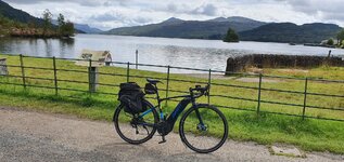
One day were going to have to tell the Scots thats its spelt Lake.View attachment 131626
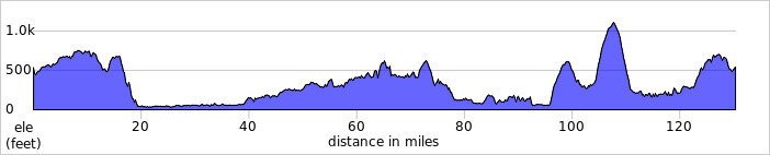
A perfect day for cyling arrived once again so it was time for another epic ride! I took 3 batteries just to be safe and it was a wise move, as it made me test them out to the limit!
Early morning view of the Ochill Hills!
View attachment 131627
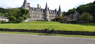
The River Teith at Doune!
View attachment 131628
At 50 miles I reached Callander and it was time to change batteries, not quite the 83 miles I achieved on my 162 mile ride! All down to the headwind and climbing of course, I was now very glad I had that 3rd battery in my bag! After Callander I turned off the main road and I was heading past all the lochs that lead to Loch Katrine which was my destination!
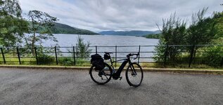
Loch Venacher!
View attachment 131629
Loch Achray!
View attachment 131630
View attachment 131631
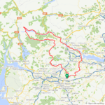
I reached Loch Katrine at 59 miles and now the real climbs were about to start, with some awesome descents also of course and as it was a Monday the path was pretty quiet for the most part! I wouldn't go near here at the weekend...
The start of Loch Katrine!
View attachment 131632
Rob Roy III pleasure boat heading back to the dock!
View attachment 131633
Some of the path round the loch is pretty rough but parts like this make up for it, lovely new tarmac has been laid and it is such a joy to ride these parts!
View attachment 131634
A little futher along the path, some lovely views of Loch Katrine!
View attachment 131635
View attachment 131636
View attachment 131637
View attachment 131638
I was now on the south side of the loch and I finally had the breeze at my back, the difference was amazing as the wind had actually picked up a bit now!
Nice views on the south side also!
View attachment 131639
The loch view at Stronachlachar!
View attachment 131640
At 80 miles I reached Loch Ard and the beautiful views just continued!
View attachment 131641
View attachment 131642
View attachment 131643
By now my mobile battery was starting to get a bit low so the photos came to an end to conserve my battery! It was time to get my head down and think about my route back home! I reached the village of Thornhill at 92 miles and I had the easy option of heading for Stirling with the wind behind me and not a lot of climbing! Or I could choose the difficult option and head through Kippen and Fintry and tackle the Campsie Hills which go up to over 1100ft from just over 300ft in 4 miles!!
I reached Kippen at 95 miles and changed to my final battery which was only charged to 80%, my thoughts were if I can get over the Campsies with 50% left (which I was confident of making with level 2 assist) I would be fine! I reached the summit with 52% left and I knew I could manage the final 22 miles comfortably with the breeze behind me for quite a few miles! What a fantastic ride that was and I even managed to eclipse my 7500ft of elevation on my 162 mile ride, my best ever at 7881ft! The rest of the week is looking very nice but I will probably just go for some walks and give my old legs a rest! I think I will sleep well tonight!
@Prairie Dog What a brilliant ride that was, well worth the long journey to see spectacular scenery like that! Truly mind blowing!
Once again, I can’t say enough about how great it must be to be able to cycle in such awe-inspiring settings so close to home. You are one lucky dude.@Prairie Dog What a brilliant ride that was, well worth the long journey to see spectacular scenery like that! Truly mind blowing!
Who doesn’t love kites on a beach plus the ones that we flew as kids were never that cool!Plus there were these awesome animal kites.
The one I flew along side Ben Franklin was a very simple affair. Just kind of diamond shaped with a key dangling from it!Who doesn’t love kites on a beach plus the ones that we flew as kids were never that cool!
View attachment 131675