View attachment 159810
On the day of the Elite Mens World Championships road race taking place on Scottish roads with the 168 mile road race running from Edinburgh to Glasgow and going up over the Campsie Hills I had to choose a route to the south well away from the crowds! So I set off at 7am heading south towards Motherwell, a place I don't go near if I can help it but with it being early on a Sunday the roads were very quiet! I even used the dual carriageway from Motherwell to Hamilton and only saw 2 cars on what can be a very busy road which leads to the main M74 motorway from Glasgow to Carlisle!
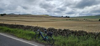
From Hamilton I started the big climb up to Strathaven and was really enjoying the quiet roads, part way up the climb to Strathaven I stopped for a quick photo! The last time I was zooming down this hill which is obviously more fun but at least its a fairly gradual climb!
View attachment 159811
I soon arrived in Strathaven and almost immediately I had a lovely descent which was followed by another climb of course...
") View attachment 159812
View attachment 159812
There were some clouds around but thankfully no threat of rain!
View attachment 159813
From Strathaven I took one of my favourite roads down to Kirkmuirhill, which is a lovely twisty flowing road and pretty fast at times! I arrived in Kirkmuirhill and stopped for a quick snack break and was just about to take a photo when a lovely old 1957 Wolseley 1500 mk1 passed by, I checked the reg no online and it was first registered for the road in November 1957 so is 4 months older than me!
View attachment 159815
This was the view to the south!
View attachment 159816
I then took the cycle path down to Lesmahagow, this used to be part of the main A74 trunk road from Scotland to England and was extremely busy back in the day!
View attachment 159817
Its a lovely downhill to the village of Uddington where I turned east towards Lanark on the main A70 which once again was very quiet, this road is so much fun to ride with lots of ups and downs and its very twisty as you can see from this photo! This is the start of the climb up to Rigside!
View attachment 159818
A short time later came my favourite part of this awesome road!
View attachment 159819
Its a very popular road for motorcyclists also!
View attachment 159820
Soon the Hyndford Bridge came into view, this is a very fast descent before the climb begins up into Lanark!
View attachment 159823
I stopped on the bridge for a photo of the River Clyde where you can see the descent I just came down, on the left!
View attachment 159824
View attachment 159825
I arrived in Lanark a short time later and had a snack break at Lanark Loch!
View attachment 159826
I then had a nice descent towards the Clyde Valley to enjoy, this is looking down into the valley from Cartland Bridge!
View attachment 159827
View attachment 159828
From here its a big climb once again up towards Braidwood, at the top of the climb I decided to turn east on to a narrow back road I haven't used before but I had an idea where it would take me! It wasn't the smoothest road but way better than the main road which was starting to get busy! I soon spotted the road to Kilncadzow which I use a lot, this part of the back road wasn't as rough thankfully and I had a nice view looking south towards Lanark!
View attachment 159834
Another view to the south just before Kilncadzow, be glad you can't smell the pile of manure!
 View attachment 159835
I soon arrived in Carluke and took the back road to Allanton, from here I could have taken the easy option and headed down to Bonkle for an easier climb but I'm not an easy option kinda guy...
So I chose the big climb up to Kirk of Shotts through Hartwood and then enjoyed the big descent down to Salsburgh, once again I had easier choices but took the big climb up past the Blackhill transmitter! At the top of the climb I grabbed my last photo which was fittingly of the Campsie Hills in the distance where the pros would be climbing later in the day in the World Championships Elite mens road race!
View attachment 159836
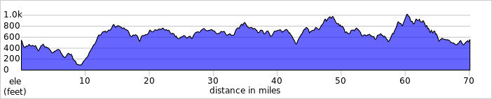
A short time later I arrived home pretty tired after over 5000ft of climbing and now I'm relaxing watching the pros on tv, riding roads that I ride and know very well!
What a brilliant day and no sign of any rain plus light winds, cycling at its very best!