Chargeride
Well-Known Member
Whats this about Californians needing an ebike licence..


Just the ones without a regular driver's license. Trying to inject some much-needed accountability and safety training into an exploding ebike scene. Much of the resulting traffic chaos comes from unsupervised kids too young to drive.Whats this about Californians needing an ebike licence..
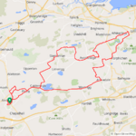
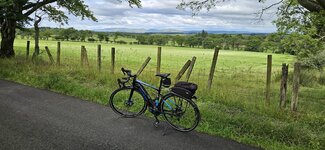
Was this all in Washington state?American Ridge Lodge to Miner's Ridge
View attachment 159482
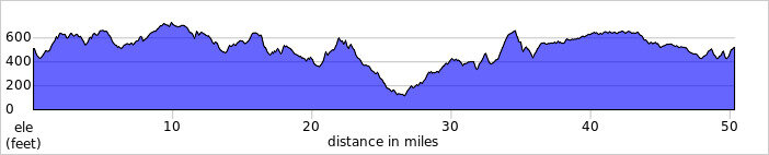
Headed east of Mt Rainier and off-grid for the weekend with another family. I was hoping to get a few rides in, but only had a window for 1 good ride so I wanted to make the most of it. We stayed at American Ridge Lodge, an old ski lodge built in the 1930's and abandoned by 1960 when larger ski runs opened up at White Pass. Mostly occupied by chipmunks now it's barely kept up and the 20 seat outhouse isn't nearly as glamorous as you might think.
The first night there just had time to take my/my son's Rock Hopper up the ridge. Here's the view looking down at the lodge from the top of an old ski run. And yes, it is definitely a ridge. My MTB skills are definitely not up much of that so I kept it brief.
View attachment 159497 View attachment 159496
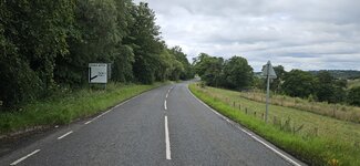
The next day was my ride window - while everyone else hung out around the cabin planning a leisurely lunch then a short hike to a nearby bat cave, I took off down the Bumping Lake Road with not much in the way of traffic.
View attachment 159483View attachment 159486
About 11 miles of pavement along the Bumping River slowly climbing about 800 feet to the lake. From there the road turns to gravel/dirt. At the turn off to Miner's Ridge the road immediately begins to climb and the with a lot of variance in the road surface. The climbing was really pretty easy with assist turned up a bit more than usual but it was slow going with a lot of sections of loose rocks and or ruts.
View attachment 159490
View attachment 159492
View attachment 159487
Most of the way to the top there's a small lake that made a nice spot to have a snack before the final climb to the top. There were a couple people camping and another couple fishing - the only folks I saw the whole climb.
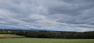
View attachment 159485 From there just a over a mile to the top where you come up around a bend and suddenly are at the top of the ~6000ft ridge with a view to die for.
Goat Rocks(extinct volcano) were visible to the south but Mt Adams was obscured by clouds above Goat Rocks.
View attachment 159489
To the SW. Don't know what that next peak over is, but it sure looked cool.
View attachment 159491
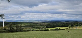
And the money shot - Mt Rainier to the west, roughly 20 miles
View attachment 159494
Spent about 30 minutes just soaking it in and taking pictures. FYI - If you have a Pixel phone any photos you take while off grid and in airplane mode don't get saved.
After that the ride went all downhill - literally! Going down was no faster than climbing as I still needed to pick around a lot of rocks and my back brakes started leaking fluid so I was basically riding my front brakes the whole way down with a couple stops to let them cool off. Got back to the lodge to find that my group was still at the day hike 8 miles away so I rode down and met them at the parking lot of their trailhead. I could have stayed on the bike and made it a metric century - but at that point, heading off for ice cream with the group was a much better choice.
Really need to go back for about a week - could easily find a ride a day.
NO! No, it wasn't! It is cloudy, and cold, and rainy here ALL THE TIMEWas this all in Washington state?
 !!!
!!!

Yes, along the American River off of state route 410 just east of Mt Rainier and Chinook Pass.Was this all in Washington state?
 Yes, she meant me! Hey, did anybody shout 'Ride slower, man!'? No I have never ridden in the peloton so how would I know?


The weather is awful at the moment in the UK. It was the sixth wettest July since 1836.View attachment 159428
More days of monsoon weather and strong winds have kept me off the bike but I spotted a weather window today and even though there was light rain falling when I set off it wasn't going to stop me! There was quite a strong easterly breeze so I was hopeful it would blow the rain through quickly, who was i kidding?A few miles further and the weather really started to close in and I was certain I was in for a real soaking! I had decided to head east to Carnwath which would be straight into the 20mph headwind to give me a nice tailwind on the way back! The roads were damp at this point but not soaking wet, but it looked like they soon would be...
Looking both north and south it looked pretty grim so I stuck with my plan to head for Carnwath, I enjoyed the lovely descent at Longridge despite the rain getting heavier and when I reached Breich I decided to head further east as the big climb up to Forth didn't look inviting in the rain! As I headed through Breich the rain eased a bit although it still looked a bit grim, eventually I turned north and took the more gradual climb up towards Forth! Now I had a nice descent to look forward to and amazingly the rain actually stopped, just before Forth I turned off the main road and took the awesome back road to Braehead, most of the time I use this road in the opposite direction which is mostly uphill so this time I had a very exhilirating downhill which made me smile despite the wet roads!
After the descent I had a big climb up to Braehead which was quickly followed by a big descent down towards Carnwath, the fastest descent of the ride where I hit 40.9mph! As I was descending the sky actually started to look a bit more promising and when I reached Carnwath the rain finally stopped and it was time to turn west with the 20mph wind right at my back! I knew I would have a big climb up to Kilncadzow though but with that wind behind me I was flying along and amazingly the roads were starting to dry up a bit! The road from Kilncadzow to Carluke is one of my favourites and its all downhill and with that wind behind me it was absolutely awesome!
From Carluke I took the back roads towards Morningside and before the village I turned north to Allanton on the quiet back roads and actually found some dry roads, something I didn't expect today! I arrived in Allanton and headed down the back road to Bonkle where I would have another big climb up to Hareshaw, from here I stuck to the back roads to Salsburgh and used the new cycle path up to the village before taking the narrow back road towards home! Amazingly I got home to dry weather and the sun was even trying to peek through, very different to when I left...
I must admit I was questioning my sanity when I saw the weather closing in but it turned out to be a very enjoyable ride and the rain actually helped to cool me down as it was quite a mild day, it was just so good to get out again and was much needed after being stuck indoors! No photos today I'm afraid, it wasn't a day for them! I couldn't believe my average speed was 17mph, I guess having that tailwind on the way back made all the difference!
Beautiful ride! There will always be rides greater and lesser than the ones you can easily ride to. That's a pretty nice one to have nearby.It’s been over a month since I last hit my own local trails so I thought that it was a good time to get reacquainted. I rode 30km of singles including Garden Hts, The Bench, The Pines and Heritage Ranch.
View attachment 159542
I’m the first one to admit that there is no rivaling the spectacular views and varied terrain of a high Rockies trip but for quick and convenient access for essential tune ups, my local lesser-known singles are enough to keep me on my toes. I've provided screenshots of of each trail to better understand their location on the larger map.
A great start to the morning along the Garden Heights single.
View attachment 159543
View attachment 159544
A favorite of mine, the Bench Trail offers up some pretty decent XC terrain with a great view atop the bluff.
View attachment 159545
View attachment 159546
View attachment 159560
No time for chit chat as we both were intently focused on finishing our rides.
View attachment 159547
The vibrant sedge along this transition along the Bench single is always a joy to ride through as it provides a soft setting to the otherwise harsh terrain.
View attachment 159548
Upon exiting the Bench, I opted to ride up to the top of this hill for a better view of the trails below.
View attachment 159549
View attachment 159550
View attachment 159551
A brief pause at the local tributary before heading off towards the Pines single.
View attachment 159552
Lots of deadfall at the Pines and a good Silky saw might have been the tool of choice to toss into the pack on this day. I was able to pull this fallen poplar to the side as it was light enough even for me to dispense.
View attachment 159561
View attachment 159553
I finished up my ride at the Heritage Ranch loop saving the easiest of the trails for last. It was nice to be back in saddle of my trusty Levo and also a temporary but welcome change up from the daily road grind.
View attachment 159554
More deadfall albeit on a slightly larger scale.
View attachment 159559
View attachment 159558
View attachment 159555
View attachment 159556
A compilation of yesterday’s ride.
Imagine how much worse it would be if we had global warming.The weather is awful at the moment in the UK. It was the sixth wettest July since 1836.
DG…
There were 2 burly guys standing at the closure and they didn't look too happy so I didn't say anything! I had to double back and take the road to Plains instead and then took the road through Caldercruix and up to Longriggend to join the road to Slamannan which was in my original plans! The road to Linlithgow was resurfaced earlier this year so its still in great condition!
 I actually passed 27000 miles on my bike today also, seems like yesterday I passed the 25000 mile mark!
Im going to have to be honest, the grey barn is not completely excitingI did 16 miles today. My goal is to ride every day this week. 2 more days a I’ll do it.
A picture of an old hand pump and an old single bottom plow yard decoration.
View attachment 159562View attachment 159563
Our roof has started leaking ..in august.The weather is awful at the moment in the UK. It was the sixth wettest July since 1836.
DG…
I was trying to capture the old well hand pump, didn’t come out so well with the limited zoom capability of a cell phone camera.Im going to have to be honest, the grey barn is not completely exciting
The previous workout had been too fast. The blame was put on me, as I was reportedly riding too fast and "pulling" the rest to ride at a crazy tempo! This time, the five of us had a serious talk about keeping below 32 km/h, how dangerous fast riding was, how bad it was for the heart etc etc. I was smart: kept in the tail of the peloton on the ride to Radziejowice. Guess what happened? The issue was the oldest rider of our group (not I!) really could not ride too fast... but he had to! Some of the larger Scottish canals can really pack a wow factor but I think that the images of the local versions that you continue to post really show off the quaint countryside in a manner that befits your homeland.As soon as I arrived in Linlithgow I left immediately taking the road south and then southwest towards Westfield! I timed it nice to catch a narrowboat passing under the bridge on the canal!
More canal boats and bridges, please sir! Lovely ride.View attachment 159539
It was a nicer day today so I set off for another 50 miler, the wind had moved to the NW today and was around 20mph again! I decided to head for Linlithgow and took one of my back roads to Greengairs only to find the road closed with no signs saying so...
This is the road from Longriggend to Slamannan which is always very quiet, from here you can see the Campsie Hills in the distance!
View attachment 159540
View attachment 159541
A similar view near Slamannan, the pro cyclists will be riding over the Campsies on Sunday in the world championships! Expect all the Strava times to get annihilated...
View attachment 159576
View attachment 159577
Love this road to Slamannan, going this way its mostly downhill!
View attachment 159579
I headed north from Slamannan towards Falkirk but I turned east in the direction of Sheildhill and enjoyed the fast descent down towards Avonbridge, 42mph here! From Avonbridge I took to yet more narrow back roads up to Standburn, I was going up the steepest part when I spotted a guy zigzagging up the hill on a mountain bike! As I was passing I said its pretty steep and he wasn't able to speak and just nodded a yes, he looked to be well into his 70's so fair play to him for taking on those climbs!
A few big climbs and descents approaching Standburn and from there to Linlithgow its pretty much downhill all the way so a lot of fun!
View attachment 159580
View attachment 159581
As soon as I arrived in Linlithgow I left immediately taking the road south and then southwest towards Westfield! I timed it nice to catch a narrowboat passing under the bridge on the canal!
View attachment 159582
View attachment 159583
A view of the Ochill Hills from near Torphicen!
View attachment 159584
View attachment 159585
I arrived in Westfield and turned south and took the big climb up to the road that leads down to Armadale, 2 really big descents here where I was over 40mph again on lovely dry roads! At Armadale it was time to turn west for home which is pretty much a straight flattish road all the way, I arrived in my home town with just over 47 miles covered so I did a little tour of my town to get it over 50 miles! Another fantastic ride and it was dry all the way this time which is always a nice bonus!
This was my 50th ride of the year and I'm now at 3441 miles, an average of almost 69 miles per ride!
@DiggyGun At least our reservoirs are getting filled up this year!
Good point. I don’t dole out enough credit and at times take the lifestyle that we are blessed with here for granted. On that day, the river made me pause for a while and reflect. There are times that I forget how its flow connects with the beauty of nature and that the river itself can indeed be a metaphor for life.Beautiful ride! There will always be rides greater and lesser than the ones you can easily ride to. That's a pretty nice one to have nearby.
Very gracious of the Red Deer River to provide all those tight meanders and oxbows and interspersed floodplains as deterrents to development. I'm sure you thank it every time you ride there.