2023 - Our Rides in Words, Photos, Maps and Videos

I’ve posted photos of a lot of old barns from this area. Most of them just don’t have a lot of useful purpose anymore, just like you say. It’s nice they gave you a tour. A lot of the ones in this area are older but I’ve only been in a few.
Farmsteads are becoming merely houses with barns next to them. The barns of yesteryear simply can’t accommodate the massive size of equipment or herds of today. If the barn is still in good structural state, it could be repurposed and might even be cheaper than demolition or construction of a new barn. Case in point, an Edmonton couple purchased this historic dairy barn for $1 but paid to move it to their property in nearby Beaumont. Unfortunately, most won’t have as happy ending but the few that do can often provide a low cost startup as a new enterprise.

1690760382489.png
 
This is one that I’d love to see restored, kind of unique in the fact that it’s a round barn. There is even a small Wikipedia page on it. It’s called the Kleinkopf Barn. I’m guessing you could throw $100,000 at it might not be enough. I’ve ridden by it several times.
IMG_1453.jpeg
 
This is one that I’d love to see restored, kind of unique in the fact that it’s a round barn. There is even a small Wikipedia page on it. It’s called the Kleinkopf Barn. I’m guessing you could throw $100,000 at it might not be enough. I’ve ridden by it several times.
View attachment 159336
Are you sure that's not a sneaky missile silo cover?
 
Last edited:
Ice Cream in Biała Rawska (Vado and Vado SL)

Since I had found Caffe Adriano in Biała Rawska, I was dreaming to taste their delicious ice cream again! It gave me the idea to ride to Biała Rawska twice on last weekend, using a different e-bike on each of the trips:
  • Saturday July 27th: Vado 6.0 at 20/80% super ECO setting, clockwise;
  • Sunday July 28th: Vado SL at 35/100% workout ECO assistance, anticlockwise.
Never ride a heavy e-bike underpowered! My Vado 6.0 really shines when powered from 40% assistance up. I hated the Saturday ride. My Vado felt sluggish, it handled climbs badly, I had to stop for recovery often, and I returned home unpleasantly exhausted. On contrary, my Vado SL felt as if it were a regular bicycle (only I had stronger legs!), agile, nicely climbing, and it gave me a good workout (I felt full of endorfin post ride!) Necessary to mention, the big Vado was faster and it gave me more assistance but it was not enough to offset the heavy weight of that e-bike!

Also the trip direction was important. The Saturday ride felt dull and boring while the Sunday trip was picturesque and exciting! (It could have had something to do with the sunshine direction during the day long ride).

1690792176213.png

A defunct railway station in Mszczonów. Railways fare well in Poland. However, Mszczonów has become a huge logistic hub for road transport and simply nobody needs the passenger trains there. Nowadays, the station only serves railroad traffic management purposes, and is a house for the personnel.

1690792605887.png

Storks arrive in Poland in April. They fly from Africa (even from South Africa) over Bosfor Strait in Turkey. Peasants help the birds settle in villages, as it is believed a stork family brings prosperity to the community (and of course storks deliver babies!) :D

1690794207004.png

Any self-respecting adventure cyclist here must bring a "sunflower photo" from their Summer ride :) Now, I've got mine!

1690794293568.png

There is an enormous fruit growing area in Central Poland (South Mazovia and East Land of Łódź). You can ride all day long to only see orchards and cereal fields there!

1690794420273.png

There it is! My roadie friend told me recently: "I was very surprised to find a place with excellent coffee and delicious ice-cream in that strange little town". So was I. Here's Caffe Adriano in Biała Rawska!

1690794609610.png

Strawberry, watermelon, and lemon ice-cream. Not sure about the lemon variety but Adriano makes their strawberry and watermelon ice-cream from fresh fruit!

1690794723985.png

If you see a crate of fruit in Adriano, be sure the fruit will find its way to ice-cream on the next day! I regret I cannot ride to Biała Rawska on every second day!

1690794820316.png

Spotted: "Fear not, Warsawer! If you drove an electric car, the worst fear of yours would be the range anxiety!" :D

1690794919572.png

Biała Rawska, Land of Łódź, is surrounded by mild hills. Whichever way you want to get to the town (or get out of it), you have to climb, climb, and climb again! (See the never-ending apple orchards).

1690795079662.png

Starting from Osuchów, Mazovia, there were mostly descents that allowed me riding on the leg power only with my Vado SL, as I had the e-bike restricted to 25 km/h and could exceed that speed often for long stretches of my trip. (You cannot do the same trick with Vado 6.0!) Here, I reached the County of Grodzisk that borders with my County of Pruszków.

1690795686777.png

In Frogsville :D (Żabia Wola). There is a House of Culture in an 1827 manor in the village. As I approached the place, I could see young kids practicing Mazovian folk dances!

1690796728485.png
1690838773165.png

Comparison of the e-bike battery vs distance ridden (L: Vado 6.0 with nominally a 604 Wh battery; R: Vado SL with 320 Wh main battery + 160 Wh Range Extender). It is very hard to empty Vado SL batteries if you are riding in economic mode!

1690838910233.png

Two similar rides. Vado 6.0 achieved higher speed and provided more assistance but was a pain to ride at low assistance. Vado SL proved a better e-bike for that type of a trip!

1690839041529.png

Exaggerated elevation profile for the trip.


EBR Forum was down all day long!
 
Last edited:
Yesterday and the day before, spent several hours exploring the same hilly inland road loop in Carlsbad, CA. The rides were short — only 11 mi and 800 vft each — with different offroad segments and side attractions each day. Still, lots to take in.

20230729_152903.jpg

The first stop on both days was a trailhead overlooking a rugged canyon on Macario Creek — much of it now a sprawling golf course with unclear boundaries. Below that was an open space with a confusing maze of "trails". And below that was a road on the loop.

Plan A for Day 1 was to take some combo of canyon trails down to the pavement. Day 2's ride would skirt the canyon instead.

Screenshot_20230731_151522_Chrome.jpg

But exactly which trail combo to take was far from clear. RideWithGPS, the Google Maps bike layer, Google Earth, the official Carlsbad trail map, the view from the trailhead, and the signage there all gave conflicting info. Really wanted to avoid backtracking uphill here.

20230729_153357.jpg

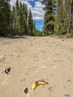
After some dithering, took the RideWithGPS route. Looked rideable from the trailhead but soon turned into a sandy rutted transmission line service road with 3 short sections that felt way too loose and steep for my 2.3" hybrid tires.With 25 years of rust on my MTB skills and much less bounce, walking all 3 seemed the better part of valor.

20230730_160826.jpg

Many of the mapped "trails" within riding distance of my house turn out to be dirt transmission line roads. Part of this one became an official public trail somehow, but most turn out to be gated and posted when you get there.

20230729_154947.jpg

Had to resort to the ebike's walking mode to get up the last unrideable pitch — a sandy grade of at least 20% (white road under transmission towers in previous photo). At the top, the bike found its happy place.

20230729_154641.jpg

While the bike basked in the 60 Hz transmission line radiation, I took in the view of Agua Hedionda Lagoon to the WNW. The 1769 Portola-Crespi expedition found only a fetid salt marsh here. Father Crespi dubbed it "San Simon Lipnica", but the soldiers gave it the name that stuck: "Agua Hedionda", meaning "stinky water". Thankfully, the smell is long gone.

20230729_154724.jpg

The lagoon was eventually opened to the ocean and dredged for sand and gravel, but a small brackish marsh still surrounds Agua Hedionda and Macario Creeks as they enter at its E end. The marsh and surrounding open space are now a bird-filled nature preserve with hiking but no biking trails.

The impressive confluence of major transmission lines here is no accident. Out of sight to the left (SW) in the lagoon shot is the Carlsbad Energy Center, a modern 632-megawatt gas-fired power plant near the mouth of the lagoon. Before they were demolished, the enormous twin smokestacks of the coal-fed plant previously at the site doubled as navigational aids important to coastal shipping.

20230729_154511.jpg

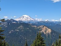
The prominent peak on the NE skyline here is Cerro de la Calavera — a deeply eroded volcanic neck composed of dacite some 15 million years old. You would have done well to be far from Carlsbad when this volcano erupted. Dacite magmas are gassy and viscous enough to make fine volcanic explosions. The 1980 Mount St. Helens explosion was a case in point.

Several other poorly preserved volcanoes of similar age and composition dot western SoCal south of LA. Why exactly is unclear, but they probably relate to a major reorganization of the local Pacific-North American plate boundary that began around that time. This sporadic early volcanism never recurred, but stay tuned. The ongoing reorganization continues to evolve.

20230730_161001.jpg

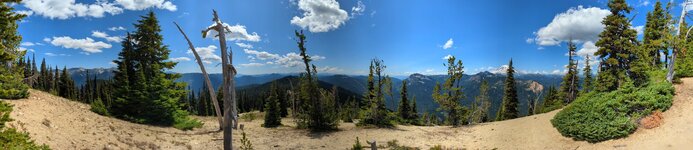
An unexpected treat looming on the N skyline from the same vantage: The Santa Margarita Mountains in the southernmost Santa Anas, some 25 mi distant.

20230730_163445.jpg

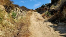
Once on pavement again, I crossed Macario Creek and climbed the other side of its canyon on beautiful, winding Faraday Avenue. This soon brought me to Day 2's offroad segment in very steep Veterans Park. Had to walk the bike here again, once up and once down, but the views at the top were worth it. The near body of water to the W here is Agua Hedionda's inner lagoon with the Pacific beyond.

20230730_164334.jpg

Both days I encountered steep, slippery grades on this weak, crumbly white sandstone that barely deserved to be called stone. Ended up walking them all.

20230729_161458.jpg

Faraday continued climbing past the E end of the golf course, where each hole (fairway+green) is an island of lush, groomed green in a harsh rugged semi-arid sea. Looks totally out of place to me, but no denying that the cart paths would be fun to ebike.

20230730_165217.jpg

Near center, note the brown golf cart bridge over a wash heading over a cliff. Could get a dandy little waterfall here in a heavy winter storm. Note to self to come back and see — in the car.

20230729_161507.jpg

Closeup of the massive retaining wall above the golf course in the last 2 photos. No visible structures on top. What could be up there to warrant such an expense?

20230730_171357.jpg

Later in the road loop, I saw what was up there: Nothing but a large, flat vacant lot where Google Earth shows a plowed field.

20230731_233256.jpg

The idea of Google Earth-era farming here isn't far-fetched. Carlsbad's many coastal and inland mesas were mostly farm fields through the 1970s, as this 1977 aerial photo shows. And strawberries and ornamental flowers are still farmed nearby.

But would a farmer build such a massive retaining wall just to add acreage? Not sure. The wall could also protect the golf course below from slides mobilized by farm irrigation.

20230730_165253.jpg

Farther up, Faraday enters the Carlsbad Research Center — a sprawling, thoroughly modern business park covering a high mesa and its seaward flank. Some of the architecture's quite stunning. This handsome building was the first of many on the road loop through the Center.

Faraday Avenue turned out to be just one of many Research Center streets bearing famous names in physics and astronomy. Brought a smile to this science buff's face.

20230729_161617.jpg
20230730_170417.jpg

One of my favorite buildings from below and up close. The dark curved windows had a blue-green-violet iridescence that reminded me of labradorite.

20230729_162512.jpg

The City of Carlsbad's fancy admin building on the edge of the mesa enjoys commanding views in all directions, as if to keep an eye on its subjects. This shot from the parking lot looks W over the golf course and the lowest Research Center buildings.

20230730_170518.jpg

Aston Pond, a spot for Research Center folks to relax and enjoy the views.

20230729_153443.jpg

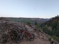
Progress! Last time I rode this hilly part of Carlsbad, I was only 3 months into my ebike-enabled return to cycling. Quite a huff then, but 7 months and 3 lower gearings later, most of the climbs were no big deal.
 

Attachments

  • 20230729_153357.jpg
    20230729_153357.jpg
    965.7 KB · Views: 153
Last edited:
But exactly which trail combo to take was far from clear. RideWithGPS, the Google Maps bike layer, Google Earth, the official Carlsbad trail map, the view from the trailhead, and the signage there all gave conflicting info.
Try Komoot and be specific it should be a "Road Bike" route.
 
Ice Cream in Biała Rawska (Vado and Vado SL)

Since I had found Caffe Adriano in Biała Rawska, I was dreaming to taste their delicious ice cream again! It gave me the idea to ride to Biała Rawska twice on last weekend, using a different e-bike on each of the trips:
  • Saturday July 27th: Vado 6.0 at 20/80% super ECO setting, clockwise;
  • Sunday July 28th: Vado SL at 35/100% workout ECO assistance, anticlockwise.
Never ride a heavy e-bike underpowered! My Vado 6.0 really shines when powered from 40% assistance up. I hated the Saturday ride. My Vado felt sluggish, it handled climbs badly, I had to stop for recovery often, and I returned home unpleasantly exhausted. On contrary, my Vado SL felt as if it were a regular bicycle (only I had stronger legs!), agile, nicely climbing, and it gave me a good workout (I felt full of endorfin post ride!) Necessary to mention, the big Vado was faster and it gave me more assistance but it was not enough to offset the heavy weight of that e-bike!

Also the trip direction was important. The Saturday ride felt dull and boring while the Sunday trip was picturesque and exciting! (It could have had something to do with the sunshine direction during the day long ride).

View attachment 159358
A defunct railway station in Mszczonów. Railways fare well in Poland. However, Mszczonów has become a huge logistic hub for road transport and simply nobody needs the passenger trains there. Nowadays, the station only serves railroad traffic management purposes, and is a house for the personnel.

View attachment 159359
Storks arrive in Poland in April. They fly from Africa (even from South Africa) over Bosfor Strait in Turkey. Peasants help the birds settle in villages, as it is believed a stork family brings prosperity to the community (and of course storks deliver babies!) :D

View attachment 159360
Any self-respecting adventure cyclist here must bring a "sunflower photo" from their Summer ride :) Now, I've got mine!

View attachment 159361
There is an enormous fruit growing area in Central Poland (South Mazovia and East Land of Łódź). You can ride all day long to only see orchards and cereal fields there!

View attachment 159362
There it is! My roadie friend told me recently: "I was very surprised to find a place with excellent coffee and delicious ice-cream in that strange little town". So was I. Here's Caffe Adriano in Biała Rawska!

View attachment 159363
Strawberry, watermelon, and lemon ice-cream. Not sure about the lemon variety but Adriano makes their strawberry and watermelon ice-cream from fresh fruit!

View attachment 159364
If you see a crate of fruit in Adriano, be sure the fruit will find its way to ice-cream on the next day! I regret I cannot ride to Biała Rawska on every second day!

View attachment 159365
Spotted: "Fear not, Warsawer! If you drove an electric car, the worst fear of yours would be the range anxiety!" :D

View attachment 159366
Biała Rawska, Land of Łódź, is surrounded by mild hills. Whichever way you want to get to the town (or get out of it), you have to climb, climb, and climb again! (See the never-ending apple orchards).

View attachment 159367
Starting from Osuchów, Mazovia, there were mostly descents that allowed me riding on the leg power only with my Vado SL, as I had the e-bike restricted to 25 km/h and could exceed that speed often for long stretches of my trip. (You cannot do the same trick with Vado 6.0!) Here, I reached the County of Grodzisk that borders with my County of Pruszków.

View attachment 159370
In Frogsville :D (Żabia Wola). There is a House of Culture in an 1827 manor in the village. As I approached the place, I could see young kids practicing Mazovian folk dances!

View attachment 159372View attachment 159376
Comparison of the e-bike battery vs distance ridden (L: Vado 6.0 with nominally a 604 Wh battery; R: Vado SL with 320 Wh main battery + 160 Wh Range Extender). It is very hard to empty Vado SL batteries if you are riding in economic mode!

View attachment 159377
Two similar rides. Vado 6.0 achieved higher speed and provided more assistance but was a pain to ride at low assistance. Vado SL proved a better e-bike for that type of a trip!

View attachment 159378
Exaggerated elevation profile for the trip.


EBR Forum was down all day long!
Those pictures are gorgeous.
Ive found more about Poland, Scotland and the States on here than 20 years of net surfing.


Oh and its still raining, it rained three days non stop, I woke up two times in the night and the roof was still roaring with monsoon rain.
But strangely no floods.
 
On Monday Mrs DG had a day off and the weather was promising with no rain forecast.

We tried a new track that we found. Part of the NCN 51 route from Sandy to Bedford.

Parked up at Willington and started from a place called Danish Camp, firstly to Sandy and secondly to Bedford.
IMG_1820.jpeg


IMG_1817.jpeg


Part of this is also known as the ”Thatchers Way”, which is a circular route, that we shall try some other day.
IMG_1071.jpeg


DG…
 
"Headwind does not pertain to e-bikers" :D
That doesn’t stop this guy on his fat bike who we come across almost daily on our analog rides. He obviously enjoys the time spent in the saddle and is likely in pretty decent shape for his age. I guess that it’s also safe to assume that he’s bumped up the PSI on those Minion FBRs.

GH012227 - frame at 0m47s.jpg
 
1690914502975.png


More days of monsoon weather and strong winds have kept me off the bike but I spotted a weather window today and even though there was light rain falling when I set off it wasn't going to stop me! There was quite a strong easterly breeze so I was hopeful it would blow the rain through quickly, who was i kidding?😂 
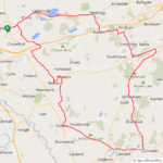
A few miles further and the weather really started to close in and I was certain I was in for a real soaking! I had decided to head east to Carnwath which would be straight into the 20mph headwind to give me a nice tailwind on the way back! The roads were damp at this point but not soaking wet, but it looked like they soon would be...

Looking both north and south it looked pretty grim so I stuck with my plan to head for Carnwath, I enjoyed the lovely descent at Longridge despite the rain getting heavier and when I reached Breich I decided to head further east as the big climb up to Forth didn't look inviting in the rain! As I headed through Breich the rain eased a bit although it still looked a bit grim, eventually I turned north and took the more gradual climb up towards Forth! Now I had a nice descent to look forward to and amazingly the rain actually stopped, just before Forth I turned off the main road and took the awesome back road to Braehead, most of the time I use this road in the opposite direction which is mostly uphill so this time I had a very exhilirating downhill which made me smile despite the wet roads!

After the descent I had a big climb up to Braehead which was quickly followed by a big descent down towards Carnwath, the fastest descent of the ride where I hit 40.9mph! As I was descending the sky actually started to look a bit more promising and when I reached Carnwath the rain finally stopped and it was time to turn west with the 20mph wind right at my back! I knew I would have a big climb up to Kilncadzow though but with that wind behind me I was flying along and amazingly the roads were starting to dry up a bit! The road from Kilncadzow to Carluke is one of my favourites and its all downhill and with that wind behind me it was absolutely awesome!:D

From Carluke I took the back roads towards Morningside and before the village I turned north to Allanton on the quiet back roads and actually found some dry roads, something I didn't expect today! I arrived in Allanton and headed down the back road to Bonkle where I would have another big climb up to Hareshaw, from here I stuck to the back roads to Salsburgh and used the new cycle path up to the village before taking the narrow back road towards home! Amazingly I got home to dry weather and the sun was even trying to peek through, very different to when I left...

I must admit I was questioning my sanity when I saw the weather closing in but it turned out to be a very enjoyable ride and the rain actually helped to cool me down as it was quite a mild day, it was just so good to get out again and was much needed after being stuck indoors! No photos today I'm afraid, it wasn't a day for them! I couldn't believe my average speed was 17mph, I guess having that tailwind on the way back made all the difference!;)
 

Attachments

  • elevation_profile181.jpg
    elevation_profile181.jpg
    22 KB · Views: 145
  • trip-129946653-map-full181.png
    trip-129946653-map-full181.png
    237.1 KB · Views: 140
American Ridge Lodge to Miner's Ridge

1000001816.png


Headed east of Mt Rainier and off-grid for the weekend with another family. I was hoping to get a few rides in, but only had a window for 1 good ride so I wanted to make the most of it. We stayed at American Ridge Lodge, an old ski lodge built in the 1930's and abandoned by 1960 when larger ski runs opened up at White Pass. Mostly occupied by chipmunks now it's barely kept up and the 20 seat outhouse isn't nearly as glamorous as you might think.

The first night there just had time to take my/my son's Rock Hopper up the ridge. Here's the view looking down at the lodge from the top of an old ski run. And yes, it is definitely a ridge. My MTB skills are definitely not up much of that so I kept it brief.
PXL_20230728_035006625.jpg
PXL_20230728_034816670.jpg


The next day was my ride window - while everyone else hung out around the cabin planning a leisurely lunch then a short hike to a nearby bat cave, I took off down the Bumping Lake Road with not much in the way of traffic.
Screenshot_20230801-193534.png
Screenshot_20230801-194432.png

About 11 miles of pavement along the Bumping River slowly climbing about 800 feet to the lake. From there the road turns to gravel/dirt. At the turn off to Miner's Ridge the road immediately begins to climb and the with a lot of variance in the road surface. The climbing was really pretty easy with assist turned up a bit more than usual but it was slow going with a lot of sections of loose rocks and or ruts.
PXL_20230728_184536278.jpg

PXL_20230728_190512484.jpg

PXL_20230728_191245301.jpg


Most of the way to the top there's a small lake that made a nice spot to have a snack before the final climb to the top. There were a couple people camping and another couple fishing - the only folks I saw the whole climb.
PXL_20230728_193109968.jpg
From there just a over a mile to the top where you come up around a bend and suddenly are at the top of the ~6000ft ridge with a view to die for.

Goat Rocks(extinct volcano) were visible to the south but Mt Adams was obscured by clouds above Goat Rocks.
PXL_20230728_195932386.jpg


To the SW. Don't know what that next peak over is, but it sure looked cool.
PXL_20230728_200220342.jpg


And the money shot - Mt Rainier to the west, roughly 20 miles
PXL_20230728_195813235.jpg

Spent about 30 minutes just soaking it in and taking pictures. FYI - If you have a Pixel phone any photos you take while off grid and in airplane mode don't get saved.

After that the ride went all downhill - literally! Going down was no faster than climbing as I still needed to pick around a lot of rocks and my back brakes started leaking fluid so I was basically riding my front brakes the whole way down with a couple stops to let them cool off. Got back to the lodge to find that my group was still at the day hike 8 miles away so I rode down and met them at the parking lot of their trailhead. I could have stayed on the bike and made it a metric century - but at that point, heading off for ice cream with the group was a much better choice.

Really need to go back for about a week - could easily find a ride a day.
 

Attachments

  • PXL_20230728_200013281.PANO.jpg
    PXL_20230728_200013281.PANO.jpg
    245.1 KB · Views: 148
  • PXL_20230728_034520196.jpg
    PXL_20230728_034520196.jpg
    542.1 KB · Views: 156
  • PXL_20230728_200254428.jpg
    PXL_20230728_200254428.jpg
    796.1 KB · Views: 150
  • PXL_20230728_213503756.jpg
    PXL_20230728_213503756.jpg
    535 KB · Views: 162
Last edited:
American Ridge Lodge to Miner's Ridge

View attachment 159482


Headed east of Mt Rainier and off-grid for the weekend with another family. I was hoping to get a few rides in, but only had a window for 1 good ride so I wanted to make the most of it. We stayed at American Ridge Lodge, an old ski lodge built in the 1930's and abandoned by 1960 when larger ski runs opened up at White Pass. Mostly occupied by chipmunks now it's barely kept up and the 20 seat outhouse isn't nearly as glamorous as you might think.

The first night there just had time to take my/my son's Rock Hopper up the ridge. Here's the view looking down at the lodge from the top of an old ski run. And yes, it is definitely a ridge. My MTB skills are definitely not up much of that so I kept it brief.
View attachment 159497 View attachment 159496

The next day was my ride window - while everyone else hung out around the cabin planning a leisurely lunch then a short hike to a nearby bat cave, I took off down the Bumping Lake Road with not much in the way of traffic.
View attachment 159483View attachment 159486
About 11 miles of pavement along the Bumping River slowly climbing about 800 feet to the lake. From there the road turns to gravel/dirt. At the turn off to Miner's Ridge the road immediately begins to climb and the with a lot of variance in the road surface. The climbing was really pretty easy with assist turned up a bit more than usual but it was slow going with a lot of sections of loose rocks and or ruts.
View attachment 159490
View attachment 159492
View attachment 159487

Most of the way to the top there's a small lake that made a nice spot to have a snack before the final climb to the top. There were a couple people camping and another couple fishing - the only folks I saw the whole climb.
View attachment 159485 From there just a over a mile to the top where you come up around a bend and suddenly are at the top of the ~6000ft ridge with a view to die for.

Goat Rocks(extinct volcano) were visible to the south but Mt Adams was obscured by clouds above Goat Rocks.
View attachment 159489

To the SE. Don't know what that next peak over is, but it sure looked cool.
View attachment 159491

And the money shot - Mt Rainier to the East, roughly 20 miles
View attachment 159494
Spent about 30 minutes just soaking it in and taking pictures. FYI - If you have a Pixel phone any photos you take while off grid and in airplane mode don't get saved.

After that the ride went all downhill - literally! Going down was no faster than climbing as I still needed to pick around a lot of rocks and my back brakes started leaking fluid so I was basically riding my front brakes the whole way down with a couple stops to let them cool off. Got back to the lodge to find that my group was still at the day hike 8 miles away so I rode down and met them at the parking lot of their trailhead. I could have stayed on the bike and made it a metric century - but at that point, heading off for ice cream with the group was a much better choice.

Really need to go back for about a week - could easily find a ride a day.
You’re right about Rainier being the money shot. Just gorgeous! :cool:
 
Back