2023 - Our Rides in Words, Photos, Maps and Videos

As soon as I arrived in Linlithgow I left immediately taking the road south and then southwest towards Westfield! I timed it nice to catch a narrowboat passing under the bridge on the canal!
Some of the larger Scottish canals can really pack a wow factor but I think that the images of the local versions that you continue to post really show off the quaint countryside in a manner that befits your homeland.
 
View attachment 159539

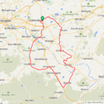
It was a nicer day today so I set off for another 50 miler, the wind had moved to the NW today and was around 20mph again! I decided to head for Linlithgow and took one of my back roads to Greengairs only to find the road closed with no signs saying so...:rolleyes: There were 2 burly guys standing at the closure and they didn't look too happy so I didn't say anything!😂 I had to double back and take the road to Plains instead and then took the road through Caldercruix and up to Longriggend to join the road to Slamannan which was in my original plans!

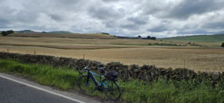
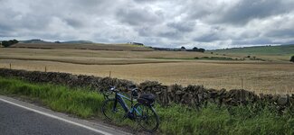
This is the road from Longriggend to Slamannan which is always very quiet, from here you can see the Campsie Hills in the distance!

View attachment 159540
View attachment 159541
A similar view near Slamannan, the pro cyclists will be riding over the Campsies on Sunday in the world championships! Expect all the Strava times to get annihilated...🤣

View attachment 159576
View attachment 159577
Love this road to Slamannan, going this way its mostly downhill!

View attachment 159579
I headed north from Slamannan towards Falkirk but I turned east in the direction of Sheildhill and enjoyed the fast descent down towards Avonbridge, 42mph here! From Avonbridge I took to yet more narrow back roads up to Standburn, I was going up the steepest part when I spotted a guy zigzagging up the hill on a mountain bike! As I was passing I said its pretty steep and he wasn't able to speak and just nodded a yes, he looked to be well into his 70's so fair play to him for taking on those climbs!

A few big climbs and descents approaching Standburn and from there to Linlithgow its pretty much downhill all the way so a lot of fun!:D The road to Linlithgow was resurfaced earlier this year so its still in great condition!👍

View attachment 159580
View attachment 159581
As soon as I arrived in Linlithgow I left immediately taking the road south and then southwest towards Westfield! I timed it nice to catch a narrowboat passing under the bridge on the canal!

View attachment 159582
View attachment 159583
A view of the Ochill Hills from near Torphicen!

View attachment 159584
View attachment 159585
I arrived in Westfield and turned south and took the big climb up to the road that leads down to Armadale, 2 really big descents here where I was over 40mph again on lovely dry roads! At Armadale it was time to turn west for home which is pretty much a straight flattish road all the way, I arrived in my home town with just over 47 miles covered so I did a little tour of my town to get it over 50 miles! Another fantastic ride and it was dry all the way this time which is always a nice bonus!

This was my 50th ride of the year and I'm now at 3441 miles, an average of almost 69 miles per ride!😮 I actually passed 27000 miles on my bike today also, seems like yesterday I passed the 25000 mile mark!;)

@DiggyGun At least our reservoirs are getting filled up this year!
More canal boats and bridges, please sir! Lovely ride.

An average of 69 miles per ride so far, eh? I'm sure you'll slack off less as the weather improves.
 
Beautiful ride! There will always be rides greater and lesser than the ones you can easily ride to. That's a pretty nice one to have nearby.

Very gracious of the Red Deer River to provide all those tight meanders and oxbows and interspersed floodplains as deterrents to development. I'm sure you thank it every time you ride there.
Good point. I don’t dole out enough credit and at times take the lifestyle that we are blessed with here for granted. On that day, the river made me pause for a while and reflect. There are times that I forget how its flow connects with the beauty of nature and that the river itself can indeed be a metaphor for life.
 
Some of the larger Scottish canals can really pack a wow factor but I think that the images of the local versions that you continue to post really show off the quaint countryside in a manner that befits your homeland.
I'm not a boat guy but watching them meander along the canals looks so relaxing, a great pastime on a nice day for sure!
More canal boats and bridges, please sir! Lovely ride.

An average of 69 miles per ride so far, eh? I'm sure you'll slack off less as the weather improves.
Its Scotland though so the weather doesn't improve really...😂
 
I did 26 miles today with nearly 1000 feet of elevation gain, which for my rides is a lot of elevation gain. Pictures of some wind turbines over a corn field and an old farm house dated 1866.
IMG_2224.jpeg
IMG_2225.jpeg
 
Went on a new route today, The Thatcher’s Way, which is near Bedford. It’s a mixture of minor B Roads and the NCN 51 cycle path.
IMG_1078.jpeg


Didnt see many barns en-route, but there where a nice mixture of buildings, from Tudor buildings, the Willington Dovecote built in 1543 and Stables built in 1539 to the Cardington Airship Hangers built in 1915.
IMG_1847.jpeg
IMG_1846.jpeg

IMG_1842.jpeg


IMG_1836.jpeg


We had three picnic stops along the way, including a nice stop at the St Swithurn Parish Church in Sandy.
IMG_1837.jpeg


Fortunately, we had nice weather today with no rain, which makes a change as of late. However, did get stung by an angry wasp that seemed to like the area behind my left ear.


DG…
 
Last edited:
Didnt see many barns en-route, but there where a nice mixture of buildings, from Tudor buildings, the Willington Dovecote built in 1543 and Stables built in 1539 to the Cardington Airship Hangers built in 1915.
Beautiful architecture! One of the downsides of living in (sometimes) sunny coastal California: A masonry structure built in the 16th century would probably be a post-seismic rubble pile by now.

Our oldest buildings are 18th century stucco Spanish missions, mostly in earthquake country. Stucco's relatively cheap and easy to repair. Not sure what's under the stucco (probably some kind of wood framing), but it seems to be pretty earthquake-resistant.
 
i've mostly been riding familiar places lately, but today was an opportunity to take a day off and go for a non-exercise ride with my older daughter. we did 39 miles at a leisurely clip, 18 miles to a train station, then 50 minute train ride, a mile or two to mini golf, go karts, arcade, then the same in reverse. she did well for a 12 year old, i rode about 2/3 the usual pace and she only complained once or twice ;)

disclaimer : no electrons were used on this ride other than in my phone and electronic shifting. 😄

cool and mellow in the morning
0912-natalieSaus-1920.jpg


headed north
0920-natalieSaus-1920.jpg


a small climb, around 100 meters, with a recently resurfaced road without it's permanent markings yet! she said she found the uphill part "relaxing," to which i said that's because she wasn't pedaling nearly hard enough!!
0930-caminoAlto-1920.jpg


back on the MUPs
0943-riding-1920.jpg


0931-millValley-1920.jpg


never ridden this train before, it's relatively new and runs through fairly thinly populated areas.
0949-smart-1920.jpg


ample space for bikes, both flat areas like this as well as hanging hooks, which we used on the way back and are much more space efficient.
5630-trainBikes-1920.jpg


nice scenery
5636-sonoma-1920.jpg


heading home now, temperatures in the 24-26c range, a bit warm for me but we were just cruising. the "mountain" center background is mt tamalpais, the birthplace of modern mountain biking, and a very nice ride to the top. she's not quite ready for that yet, but she loves riding downhill, so....
0953-tam-1920.jpg


the usual strong crosswinds on the golden gate, but she did well.
1008-natalieBridge-1920.jpg


backpack full of alternate clothing layers, locks, games for the train ride, etc was a bit heavy to ride with but i was only going about 1/2 as hard as usual most of the time, so no big deal. interesting how riding 1/2 or less as hard only results in going 1/3 slower. physics!!
1026-finished-1920.jpg
 
i've mostly been riding familiar places lately, but today was an opportunity to take a day off and go for a non-exercise ride with my older daughter.
What a fantastic post! Thank you!
disclaimer : no electrons were used on this ride other than in my phone and electronic shifting. 😄
I only could not stop thinking that if your daughter's bike were electrically assisted, she would not need to pedal off-saddle :)

Cherry Ice Cream in Biała Rawska (4th Caffe Adriano Ride)

As rainfall and thunderstorms were predicted for this weekend, I took an opportunity for a longer ride on sunny Friday.

1691220836937.png

At a Żabka (Little Frog) chain-store in Kuklówka. Żabka is our 7-11, where I could buy protein drink, fruit mousse, and energy bars. You need to be fed and hydrated well on a long ride during a warm Summer day! My Roadrunner was properly fed with electrons this time, too! :)

1691221039490.png

I have never realised the thing such as a "big tree farm" could exist! Fancy how patient the owners are: to plant a tree and then wait for 10 years or more to sell it?


1691221177641.png

It is the harvest time! The combine harvester in a cloud of dust is barely visible far left. In another place, I could see a family of storks feeding in the stubble field. I regret I did not stop for a photo there!

1691221380759.png

The crate of cherries found its way to natural ice cream four days earlier. I knew the cherry ice cream would be made, so I dreamed of tasting the product! It was delicious!

1691221618658.png

If any cyclist asks the question 'Where the nearest to Warsaw can I find any hills?' then the immediate answer is 'Try a Biała Rawska ride!' The hills there are mild but still require some effort from the rider (the maximum climb en route was 6.7%). Here, approaching the summit of the trip (it took me 12 minutes to reach the summit since taking the photo).


STOP means STOP
When I approach a STOP sign (especially for the railroad crossing), I apply the "Idaho Stop". That is, I slow down to the walking speed and carefully watch the crossing. If nothing's there, I ride on.

1691222034342.png

This time, I knew I had to stop because I could see cars stopped at the opposite side of the crossing. I also could hear a distant noise. In several seconds, a locomotive crossed the road! (It was a rail crossing without barriers). As the locomotive quickly disappeared behind the trees, there came a roadie who just zoomed through the crossing at high speed, even not looking around!

A 9.5 km Chase
I am usually tired and hot after many kilometres covered on a Summer ride. Demotivated, I ride slowly and do not enjoy the trip. Unless... there is a roadie who had overtaken me! :) This time, I started chasing the man, and I can tell you he was good! I thought it would be okay to greet him, so I turned the Turbo mode on and we rode two abreast at a high speed.

'Hi! Thank you for the workout...' -- I started, to which he looked at me as if I were invisible, said 'Huh?' then he removed an earbud from his ear! The guy was not only blind when he was riding through the rail crossing! He was deaf, too! A Darwin's Award candidate!
'Hi! Thank you for the workout and the adrenaline rush! It is fun to be chasing you! Are you from the Vamos Książenice cycling club?' -- to which he mumbled something, I just smiled at him and let him take the lead again.

1691224250078.png

I achieved a Strava E-Bike Course Record on that long segment!

The guy accelerated. He probably felt offended to be caught up by an e-biker, so he tried escaping. I went back to the 70% SPORT assistance and was pedalling hard! (I was on a road cycling workout the day before, wasn't I :D) The speed was increasing... At 45 km/h the motor cut off, so I increased my effort unpowered (we both were riding with tailwind). 47... 48... The max speed was 48.5 km/h! I eased up a little, the guy increased his lead but I thought to myself I would not let him get away with it :) So I increased my effort. And he lost his strength :) As we split in Żelechów, he had only a several seconds' lead! :)

Just fancy that. Me, with three ailments; a man who can hardly walk but can pedal. My physical shape has improved since I started working out hard! I wish the same to any of you! ♥️

1691223692060.png

It was a good day! Now, it's raining!
 
Last edited:
Baranów Classic Ride, Or How I Thought The Motor Of My Vado SL Broke :D

A heavy morning rainfall had scared of most of cyclists in the area. I checked the weather forecast to see there would be no raining in the afternoon, so set off for a greater neighbourhood ride in the footsteps of a Strava friend (a neighbour from the next town).

A Motor Failure? Not!
During the first five kilometres into the ride, my Vado SL felt weird. It was overly slow, and the motor sounded loud, grating, like it were close to be seized. I started panicking: 'Oh, no, some Forum members must have been right! My motor's dying! I'm unprepared to buy a new motor now! I will lose my daily ride again!" and so on :) When I got on a segment with a tailwind and the speed was only 21 km/h, I put the motor in the OFF mode; hardly anything changed! And the battery consumption was overly low! I had to stop and check the things out!

@mfgrep: It was the BLEvo app :D While BLEvo is extremely useful for Specialized e-bikes, it has a bug. When you start monitoring the bike, it picks up the latest assistance settings used! Therefore, the ECO was 20/80%, and SPORT was 50/80% :D While those settings were good for Vado 6.0, those were just ridiculous for the Vado SL (I use 55/55% ECO for that e-bike) :) After I adjusted the assistance settings, I could happily continue the ride!

1691302747063.png

This place-name makes me laugh. Translated, it is "(It's) Fat" :)

1691302829340.png

There's nothing interesting about Baranów itself (it was just the westernmost tip of the ride). The ruling party of Poland wants to condemn a huge area around for an enormous airport we do not need at all. I hope the civil disobedience would prevent the project come true!

1691302976153.png

It is the harvest time in Poland. As I have found, it is easy to spot stork families; it is just enough to stop by a stubble field.

1691303105810.png

North America had her freeways constructed years ago. It is still a new thing for Poland, as the most of motorways were built for Euro 2012 football championship here. In the past, I was dreaming we had freeways. Now, I see them as huge rivers splitting the country, with bridges or tunnels necessary to cross them...

1691303280159.png

Two new items of cycling clothing in my wardrobe: a Northwave jersey, and Castelli bibs (with braces). I'm fond of the new clothes, only the bib braces could be longer a little bit!

1691303419768.png

The place by name of Chylice is a true sh*thole, with everything closed on Saturdays! As I was close to starvation, I decided to stop for a pizza (the option was kebab the next door) even if I had to wait for 25 minutes to get my food. The dough was just genial but there was too much of meat on the top, especially the sausage I did not like. Saved from the death, I could go on the return ride!


The return ride was terrible, as the route author chose damaged gravel or dirt roads, and those had to be ridden just after the rainfall...

1691303858102.png

This place brings fond memories related to @Brix who lived there for awhile, and she was on an e-bike ride with me to Opypy to revisit the place later. @Chargeride: It is not "Oh-pie-pie"! :D (The closest is "oh-pee-pee"). But again, I only learned it was "see-trus" not "si-trus" for "citrus" only two days ago! And why it is "clee-nic" not "cli-nic"?! :D

1691303996180.png

The true metrics for my ride. The battery % used refers to the main battery + Range Extender combo.


1691304100527.png

Ride Map. @rochrunner looked at the ride on Strava and said: 'It's very flat!' Oh yes, the central Mazovia (around Warsaw) is totally flat! (only 100 m elevation gain for 70 km ridden!)
 
Last edited:
Let me start by saying, that much like "beauty" "adventure" is in the eye of the beholder. I went on a quite adventurous ride at Spruce Knob in WV. The map suggested a 17 mi "hiker biker" route starting at the Seneca Creek Parking area. You seasoned map readers will immediately see the fatal flaw in this thinking!

IMG_20230803_083015008.jpg

The trail leading down Seneca Creek was wide and well maintained with some really nice "outback" campsites situated next to Seneca Creek. I think this is the cleanest running running water I have seen anywhere of late!
IMG_20230803_085248171.jpg


IMG_20230803_090647760.jpg

After crossing this creek and moving forward I began to question my decision.
IMG_20230803_095208426.jpg

the Judy Springs trail kicked my ass! Trail is purpendicular to the topography lines. The ascent was soooo steep, I had to use throttle and push my bike up hill on a narrow horsepath until I was thoroughly exhausted! Then as I was taking this picture, the skies now unleashed on me.
IMG_20230803_103957131_HDR.jpg

after what seemed like an eternity, I felt I had the strength to move on. The map indicated I had only completed about 1/2 of the climb so I was looking to bail. Fortunately I crossed the Lumberjack Trail which I considered to be an "easy out" as it follows the contour line back to the road. Not too easy as it turned out to be a 4 mile rock garden, and it continued to shower continuously. Sorry, no more pics as I was focused on getting out. I saw myself as one of those greenhorn tourists that could have ended up with serious consequences.
I was pleased that my DIY kit with its torque sensing capability carried me flawlessly thru that long ass rock garden in the pouring rain for like 2 hours or more!
IMG_20230803_131351937_HDR.jpg

my humble abode for the week.
IMG_20230802_083804294.jpg

adventure? misadventure?
stupidity? all of the above!
 
1691325363790.png


On the day of the Elite Mens World Championships road race taking place on Scottish roads with the 168 mile road race running from Edinburgh to Glasgow and going up over the Campsie Hills I had to choose a route to the south well away from the crowds! So I set off at 7am heading south towards Motherwell, a place I don't go near if I can help it but with it being early on a Sunday the roads were very quiet! I even used the dual carriageway from Motherwell to Hamilton and only saw 2 cars on what can be a very busy road which leads to the main M74 motorway from Glasgow to Carlisle!

From Hamilton I started the big climb up to Strathaven and was really enjoying the quiet roads, part way up the climb to Strathaven I stopped for a quick photo! The last time I was zooming down this hill which is obviously more fun but at least its a fairly gradual climb!

1691326050215.png

I soon arrived in Strathaven and almost immediately I had a lovely descent which was followed by another climb of course... ;)

1691326186060.png

There were some clouds around but thankfully no threat of rain!

1691326265898.png

From Strathaven I took one of my favourite roads down to Kirkmuirhill, which is a lovely twisty flowing road and pretty fast at times! I arrived in Kirkmuirhill and stopped for a quick snack break and was just about to take a photo when a lovely old 1957 Wolseley 1500 mk1 passed by, I checked the reg no online and it was first registered for the road in November 1957 so is 4 months older than me!:D

1691326783775.png

This was the view to the south!

1691326847309.png

I then took the cycle path down to Lesmahagow, this used to be part of the main A74 trunk road from Scotland to England and was extremely busy back in the day!

1691327009516.png

Its a lovely downhill to the village of Uddington where I turned east towards Lanark on the main A70 which once again was very quiet, this road is so much fun to ride with lots of ups and downs and its very twisty as you can see from this photo! This is the start of the climb up to Rigside!

1691327313027.png

A short time later came my favourite part of this awesome road!

1691327511663.png

Its a very popular road for motorcyclists also!

1691327601047.png

Soon the Hyndford Bridge came into view, this is a very fast descent before the climb begins up into Lanark!

1691327948331.png

I stopped on the bridge for a photo of the River Clyde where you can see the descent I just came down, on the left!

1691328109100.png

1691328159726.png

I arrived in Lanark a short time later and had a snack break at Lanark Loch!

1691328274400.png

I then had a nice descent towards the Clyde Valley to enjoy, this is looking down into the valley from Cartland Bridge!

1691328419492.png

1691328460606.png

From here its a big climb once again up towards Braidwood, at the top of the climb I decided to turn east on to a narrow back road I haven't used before but I had an idea where it would take me! It wasn't the smoothest road but way better than the main road which was starting to get busy! I soon spotted the road to Kilncadzow which I use a lot, this part of the back road wasn't as rough thankfully and I had a nice view looking south towards Lanark!

1691330229383.png

Another view to the south just before Kilncadzow, be glad you can't smell the pile of manure!😂

1691330368408.png

I soon arrived in Carluke and took the back road to Allanton, from here I could have taken the easy option and headed down to Bonkle for an easier climb but I'm not an easy option kinda guy...;) So I chose the big climb up to Kirk of Shotts through Hartwood and then enjoyed the big descent down to Salsburgh, once again I had easier choices but took the big climb up past the Blackhill transmitter! At the top of the climb I grabbed my last photo which was fittingly of the Campsie Hills in the distance where the pros would be climbing later in the day in the World Championships Elite mens road race!

1691330901949.png

A short time later I arrived home pretty tired after over 5000ft of climbing and now I'm relaxing watching the pros on tv, riding roads that I ride and know very well!:D What a brilliant day and no sign of any rain plus light winds, cycling at its very best!👍
 

Attachments

  • 1691327813810.png
    1691327813810.png
    2.9 MB · Views: 85
  • elevation_profile183.jpg
    elevation_profile183.jpg
    23.7 KB · Views: 76
  • trip-130469002-map-full183.png
    trip-130469002-map-full183.png
    341.7 KB · Views: 79
  • 20230806_094154.jpg
    20230806_094154.jpg
    418.3 KB · Views: 78
Let me start by saying, that much like "beauty" "adventure" is in the eye of the beholder. I went on a quite adventurous ride at Spruce Knob in WV. The map suggested a 17 mi "hiker biker" route starting at the Seneca Creek Parking area. You seasoned map readers will immediately see the fatal flaw in this thinking!

View attachment 159801
The trail leading down Seneca Creek was wide and well maintained with some really nice "outback" campsites situated next to Seneca Creek. I think this is the cleanest running running water I have seen anywhere of late!
View attachment 159802

View attachment 159803
After crossing this creek and moving forward I began to question my decision.
View attachment 159804
the Judy Springs trail kicked my ass! Trail is purpendicular to the topography lines. The ascent was soooo steep, I had to use throttle and push my bike up hill on a narrow horsepath until I was thoroughly exhausted! Then as I was taking this picture, the skies now unleashed on me.
View attachment 159805
after what seemed like an eternity, I felt I had the strength to move on. The map indicated I had only completed about 1/2 of the climb so I was looking to bail. Fortunately I crossed the Lumberjack Trail which I considered to be an "easy out" as it follows the contour line back to the road. Not too easy as it turned out to be a 4 mile rock garden, and it continued to shower continuously. Sorry, no more pics as I was focused on getting out. I saw myself as one of those greenhorn tourists that could have ended up with serious consequences.
I was pleased that my DIY kit with its torque sensing capability carried me flawlessly thru that long ass rock garden in the pouring rain for like 2 hours or more!
View attachment 159806
my humble abode for the week.
View attachment 159807
adventure? misadventure?
stupidity? all of the above!
Nicely done. Trailforks shows the last reports describing this diamond trail as being not well suited if one is looking for flowy singles. Very technical and rocky…my kinda ride. Sometimes you ask yourself if it’s going to be worth all of the sweat equity that you’ve invested. When you reach the top and realize where it took you then it all makes sense. I’m sure that arriving back at base camp never looked and felt better after that adventure. Kudos.
 
View attachment 159810

On the day of the Elite Mens World Championships road race taking place on Scottish roads with the 168 mile road race running from Edinburgh to Glasgow and going up over the Campsie Hills I had to choose a route to the south well away from the crowds! So I set off at 7am heading south towards Motherwell, a place I don't go near if I can help it but with it being early on a Sunday the roads were very quiet! I even used the dual carriageway from Motherwell to Hamilton and only saw 2 cars on what can be a very busy road which leads to the main M74 motorway from Glasgow to Carlisle!

From Hamilton I started the big climb up to Strathaven and was really enjoying the quiet roads, part way up the climb to Strathaven I stopped for a quick photo! The last time I was zooming down this hill which is obviously more fun but at least its a fairly gradual climb!

View attachment 159811
I soon arrived in Strathaven and almost immediately I had a lovely descent which was followed by another climb of course... ;)

View attachment 159812
There were some clouds around but thankfully no threat of rain!

View attachment 159813
From Strathaven I took one of my favourite roads down to Kirkmuirhill, which is a lovely twisty flowing road and pretty fast at times! I arrived in Kirkmuirhill and stopped for a quick snack break and was just about to take a photo when a lovely old 1957 Wolseley 1500 mk1 passed by, I checked the reg no online and it was first registered for the road in November 1957 so is 4 months older than me!:D

View attachment 159815
This was the view to the south!

View attachment 159816
I then took the cycle path down to Lesmahagow, this used to be part of the main A74 trunk road from Scotland to England and was extremely busy back in the day!

View attachment 159817
Its a lovely downhill to the village of Uddington where I turned east towards Lanark on the main A70 which once again was very quiet, this road is so much fun to ride with lots of ups and downs and its very twisty as you can see from this photo! This is the start of the climb up to Rigside!

View attachment 159818
A short time later came my favourite part of this awesome road!

View attachment 159819
Its a very popular road for motorcyclists also!

View attachment 159820
Soon the Hyndford Bridge came into view, this is a very fast descent before the climb begins up into Lanark!

View attachment 159823
I stopped on the bridge for a photo of the River Clyde where you can see the descent I just came down, on the left!

View attachment 159824
View attachment 159825
I arrived in Lanark a short time later and had a snack break at Lanark Loch!

View attachment 159826
I then had a nice descent towards the Clyde Valley to enjoy, this is looking down into the valley from Cartland Bridge!

View attachment 159827
View attachment 159828
From here its a big climb once again up towards Braidwood, at the top of the climb I decided to turn east on to a narrow back road I haven't used before but I had an idea where it would take me! It wasn't the smoothest road but way better than the main road which was starting to get busy! I soon spotted the road to Kilncadzow which I use a lot, this part of the back road wasn't as rough thankfully and I had a nice view looking south towards Lanark!

View attachment 159834
Another view to the south just before Kilncadzow, be glad you can't smell the pile of manure!😂

View attachment 159835
I soon arrived in Carluke and took the back road to Allanton, from here I could have taken the easy option and headed down to Bonkle for an easier climb but I'm not an easy option kinda guy...;) So I chose the big climb up to Kirk of Shotts through Hartwood and then enjoyed the big descent down to Salsburgh, once again I had easier choices but took the big climb up past the Blackhill transmitter! At the top of the climb I grabbed my last photo which was fittingly of the Campsie Hills in the distance where the pros would be climbing later in the day in the World Championships Elite mens road race!

View attachment 159836
A short time later I arrived home pretty tired after over 5000ft of climbing and now I'm relaxing watching the pros on tv, riding roads that I ride and know very well!:D What a brilliant day and no sign of any rain plus light winds, cycling at its very best!👍
It must have been a thrill to have ridden familiar roads where the pros would be cycling hours later. Just another epic ride that we would expect from you. 👍
 
It must have been a thrill to have ridden familiar roads where the pros would be cycling hours later. Just another epic ride that we would expect from you. 👍
For sure PD, I was on different roads today though as all those roads have been closed since 10pm on Saturday night! One of the farmers at the Campsies has decked some of his Highland cows out in cycling kit with the world champions jersey! 🤣

1691338965396.png
 
For sure PD, I was on different roads today though as all those roads have been closed since 10pm on Saturday night! One of the farmers at the Campsies has decked some of his Highland cows out in cycling kit with the world champions jersey! 🤣

View attachment 159840
Those two must be special to able to don the rainbow jerseys. Good to know as the rest of the peloton needs to be steered in the right direction. 😂
 
It seemed like another typical ride this morning but it came with a reminder of how we have become so reliant on electronic devices. Normally my better half and I ride together but she forgot to charge one of her gadgets the day before and wouldn’t leave the house without it. I departed on my own knowing that she would head off as soon as her device was good to go. We eventually met halfway along the route and continued on our separate ways. I’ve never known her to wear a timepiece since we met but now, she is, at no time, without her Garmin watch which seems to monitor her every move, bodily functions/sleep patterns and ride metrics. The day before it was my Varia that suffered the same fate and I felt anxious not hearing its familiar beeps. Thankfully, neither of us are emotionally tied to our phones.

GH012257 - frame at 0m2s.jpg

Another fine start to the day and a light tailwind coming home. As a bonus, I even managed to sync the traffic cycles at several signalized intersections without interrupting my momentum as I rode back into town. 👍

PXL_20230806_182749902.jpg
 
Back