Pennsylvania Rides | Meetups | Pennsylvania Riders

Thanks @6zfshdb and @J.R. for the all the help - I'll do the GAP this week. Weather forecasts look perfect for Cumberland, Frostburg, Garret, and Confluence. Does the weather along the trail vary from the weather in the towns? Not sure if I should pack extra layers if it is expected to be colder/rainier than forecast in the individual towns I mentioned.

Last question I'll bug you guys with - is the stretch from Cumberland to Frostburg more or less scenic than the stretch west from Confluence towards Ohiopyle? I am interested in nice mountain scenery.
 
Last edited:
Thanks @6zfshdb and @J.R. for the all the help - I'll do the GAP this week. Weather forecasts look perfect for Cumberland, Frostburg, Garret, and Confluence. Does the weather along the trail vary from the weather in the towns? Not sure if I should pack extra layers if it is expected to be colder/rainier than forecast in the individual towns I mentioned.

There is an 1700' elevation change between Cumberland and the top of Big Savage Mountain. The temp can sometimes vary by 10 degrees. This time of year, it's best to wear layered clothing. If your bike doesn't have a headlight, it's also a good idea to carry a flashlight for the tunnels. They are lit inside but not very well. Some of the lights can be out which creates dark sections.

Another thing to consider when riding from Cumberland up to Big Savage is the trail slope. Depending on your bike, battery and the effort you put into pedaling, you can easily exhaust a good portion of a battery during the climb. Yes, you can almost coast back down but you lose some efficiency in the process.

Even though the ride you plan is within the normal range you get with a battery on a level ride, it may be considerably less when you take on this long slope. As a result, I always carry a spare.

Cumberland to Frostburg and on to Garret is a good deal more scenic than the section west of Confluence toward Ohiopyle.
 
Last edited:
@ J.R., I see from one of your GAP pics you use Bontrager Interchange Trunk bags:

View attachment 67395

Do you ride a Trek with a compatible rear rack or do you use a Bontrager seatpost rack?

I've been using these Bontrager bags for years on my Trek MTB's. As you know, they're a snap to install & remove which makes them ideal for swapping between bikes. The foldout panniers are also a great feature for carrying light cargo like jackets or rain gear.

They wouldn't fit my e-bike so I had to make a rear rack adapter. The seatpost mount racks are ok but don't carry as much weight. I don't have enough post showing anyway so it wasn't an option.
The bag and rack were gifts from my wife about 8 years ago. I had it mounted on a 700c road hybrid bike I was using for commuting. I thought at the time it was the coolest setup I'd ever seen. Like you say quick and easy. A few bikes later and it's still going strong. It's a standard type rack that attaches to the seat stays and down near the dropouts. It's currently mounted on a BH 29er eMTB. The rack was designed for a 700c, so same diameter basically as a 29er, but it wasn't designed for disc brakes. I had to add my own spacers to clear the caliper bolts. My buddy bought the same system long before we knew each other. The only problem we have is when we stop for a break somewhere we're always reaching into each others bags. I'm thinking of putting a mouse trap in there😛

They are great bags. Maybe they were too good and lasted too long because I think Trek replaced them with a new line that I'm not crazy about. I'm not crazy about seatpost racks either. I owned one years ago and half the time I'd kick it while mounting the bike because it sat so high. Everytime I kicked it, it moved.
 
Thanks @6zfshdb and @J.R. for the all the help - I'll do the GAP this week. Weather forecasts look perfect for Cumberland, Frostburg, Garret, and Confluence. Does the weather along the trail vary from the weather in the towns? Not sure if I should pack extra layers if it is expected to be colder/rainier than forecast in the individual towns I mentioned.

Last question I'll bug you guys with - is the stretch from Cumberland to Frostburg more or less scenic than the stretch west from Confluence towards Ohiopyle? I am interested in nice mountain scenery.
What 6z said. Spot on, I think. I like to take thin layers on these mountain rides. I guess there's a reason they have all those windmills out there, always seems breezy out west in the mountains. That and a 45 degree morning you'll appreciate being prepared.

Enjoy! I'm looking forward to a ride report with pics.
 
The only problem we have is when we stop for a break somewhere we're always reaching into each others bags. I'm thinking of putting a mouse trap in there😛

They are great bags. Maybe they were too good and lasted too long because I think Trek replaced them with a new line that I'm not crazy about. I'm not crazy about seatpost racks either. I owned one years ago and half the time I'd kick it while mounting the bike because it sat so high. Everytime I kicked it, it moved.

My brother and I have identical bikes & bags and we have the same problem. :)

I agree about the new Bontrager line. I was lucky enough to grab an old style to keep as a spare.

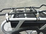
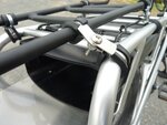
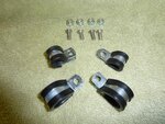
It was quite a hassle to adapt the Bontrager bag to my Pedego rear rack. It's part of the frame and an aftermarket rack won't fit. I had to cut the top off a spare Trek rack and attach it to the Pedego using the insulated cable clamp trick:

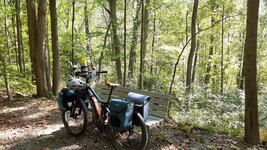
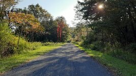
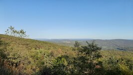
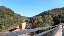
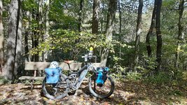
P1070100a.jpg P1070101a (1).jpg P1070096a.jpg P1060991b.jpg

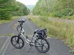
BTW, the last pic is what the surface of the Pike 2 Bike Trail looks like.
 
My brother and I have identical bikes & bags and we have the same problem. :)

I agree about the new Bontrager line. I was lucky enough to grab an old style to keep as a spare.

It was quite a hassle to adapt the Bontrager bag to my Pedego rear rack. It's part of the frame and an aftermarket rack won't fit. I had to cut the top off a spare Trek rack and attach it to the Pedego using the insulated cable clamp trick:

View attachment 67545 View attachment 67546 View attachment 67543 View attachment 67547

BTW, the last pic is what the surface of the Pike 2 Bike Trail looks like.
You can't tell it's a DIY solution when the bag is on the bike. Trek still has the bag hardware listed for sale. I expect the bag to wear out before the mount though.


Before reading your photo caption I guessed it was either the Pike2bike or Centralia, PA. Both have that post apocalyptic look to them. There was a 2009 movie called 'The Road' that was partially filmed at the abandoned turnpike. I haven't seen it, always meant to.
 
I visited Centralia a few years ago. Much worse looking than P2B because of paved street grid with curbs and some foundations still visible. While we were there smoke or steam was drifting out of a hole by the side of the road.
 
I visited Centralia a few years ago. Much worse looking than P2B because of paved street grid with curbs and some foundations still visible. While we were there smoke or steam was drifting out of a hole by the side of the road.

I guess I can cross that off my list of places to ride. :(
 
Well, I was in a car, but I don't remember any other traffic. I wouldn't go back by it unless it was on the way to somewhere else. Actually I think I was on my way to Pottsville and the old Yingling brewery when I drove thru.
 
I guess I can cross that off my list of places to ride. :(
There's not much to see anymore. Earlier this year the graffiti highway was covered with thousands of tons of dirt.


In recent years kids with 4 wheelers and dirt bikes have used the roads for races and people have been seriously injured. It's really out of the way for firefighters and rescue workers. In addition people were constantly setting the asphalt roads on fire.

It was a cool destination in the late 90's when there was still half a deserted town standing.
 
I'd be interested depending on the date. The trick will be deciding on the section of trail to ride. The entire trail is beautiful, the northern end a little more picturesque. Later October is probably better for fall foliage (after second week), unless we get one of those odd Halloween snow storms:eek:

I think a couple of us will be doing the Western Maryland Rail Trail again this fall. With the occasional detour for food and sights that's almost 60 miles r/t. Last year it was 58 miles. 95% paved. Hope to get to the C&O again too.

It looks like wind & rain from hurricane Delta will hit the Cumberland Valley this weekend. The fall foliage is about to peak in the area and unfortunately, this may ruin the color on the WMRT and portions of the GAP trails.

Hopefully, bikeman242 was able to see some of it on his recent trip.
 
It looks like wind & rain from hurricane Delta will hit the Cumberland Valley this weekend. The fall foliage is about to peak in the area and unfortunately, this may ruin the color on the WMRT and portions of the GAP trails.

Hopefully, bikeman242 was able to see some of it on his recent trip.
Color will probably peak in the next week here in central PA, I think your right.

20201008_094319.jpg

I rode the Susquehanna River trail on Tuesday and the weather was perfect! Not great color, but not bad. The trail runs through some farm fields and the beans were almost ready for harvest. Looked like autumn. The river was shockingly low. Probably 10 to 12 feet down from normal. We were able to walk out on the river about a quarter to a third of the way across. Normally I'd have been completely under water where we were. Very dry!

BTW the Northwest Lancaster County River Trail will be paved end to end, from Columbia to Falmouth, after this week (I think). They were paving the 3 to 4 mile northern extension when we were there. That would be a good destination ride for the next couple weeks. Easy ride.
 
It looks like wind & rain from hurricane Delta will hit the Cumberland Valley this weekend. The fall foliage is about to peak in the area and unfortunately, this may ruin the color on the WMRT and portions of the GAP trails.

Hopefully, bikeman242 was able to see some of it on his recent trip.

Was at the GAP this week. If you are thinking of going, from a foliage perspective, do it asap.

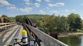
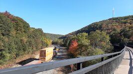
Monday, I rode from Frostburg to Cumberland and back, 32 miles. Foliage was likely the beginning of the peak on this leg. I used three times the amount of battery on the uphill as I did the downhill!! Thanks to @6zfshdb for the advice to bring a spare battery, I needed it.

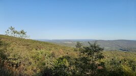
Tuesday, I rode from Frostburg to a few miles past Garrett. Weather was shockingly perfect. The peak at these higher elevations is right now, and maybe already a few days past the peak. Trees were 50% yellow, 15% red, 10% green, and the rest bare. Some great views on the ride from Frostburg up to Big Savage Tunnel. The stretch past Garrett towards Rockwell was very peaceful.

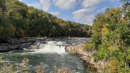
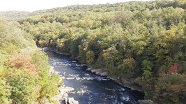
Wednesday, I wanted to check out Ohiopyle Park, so I started at Confluence and rode out towards Connellsville. The stretch along the Ohiopyle gorge was quite scenic. The Ohiopyle falls were nice. Winds were strong on Wednesday, and a whole lot of leaves got blown off the trees. Probably just at the start of peak foliage along this stretch too. More green than yellow at these elevations. Won't last long.

A surprisingly large number of people came up and asked about my Old Man Mountain racks. They worked great. Solid as a rock.

Stayed in Frostburg, was a nice little town. Shame it was mostly closed due to covid, I would have enjoyed walking around the downtown. Had a good meal (takeout) at some saloon on main street.

Big thanks to @6zfshdb and @J.R. for all the advice. Great riding. Next year I'll try and plan a thru ride from dc to pitt instead of doing roundtrips.

Hoping to get to the pine creek gorge next week, but after the rain early in the week, the peak foliage may have ended and I'll miss it.
 

Attachments

  • 20201007_132242.jpg
    20201007_132242.jpg
    846.4 KB · Views: 358
  • 20201006_170902.jpg
    20201006_170902.jpg
    760.8 KB · Views: 346
  • 20201006_165512.jpg
    20201006_165512.jpg
    450 KB · Views: 331
  • 20201006_155323.jpg
    20201006_155323.jpg
    582.5 KB · Views: 350
  • 20201006_141924.jpg
    20201006_141924.jpg
    944.6 KB · Views: 346
  • 20201007_151845.jpg
    20201007_151845.jpg
    695.1 KB · Views: 343
  • 20201007_145705.jpg
    20201007_145705.jpg
    511 KB · Views: 348
  • 20201007_145135.jpg
    20201007_145135.jpg
    885.7 KB · Views: 346
  • 20201006_165512.jpg
    20201006_165512.jpg
    450 KB · Views: 339
  • 20201006_155323.jpg
    20201006_155323.jpg
    582.5 KB · Views: 363
Thanks for the pics. Very scenic even though not much color this year.
 
Thanks for the pics. Very scenic even though not much color this year.

There was actually a lot of color, my camera on my cell phone is poor quality. Vibrant yellows. The whole time i wished i had a better camera.

I hope pine creek gorge still has color at the end of next week. Planning on going thursday hopefully.
 
There was actually a lot of color, my camera on my cell phone is poor quality. Vibrant yellows. The whole time i wished i had a better camera.

I hope pine creek gorge still has color at the end of next week. Planning on going thursday hopefully.
I rode the D&H Trail in northern Wayne County yesterday and met a fellow rider who was up at Pine Creek on Wednesday, 10/7. FWIW, he said the color was peaking on the ridge tops and near peak in the lower gorge.

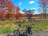
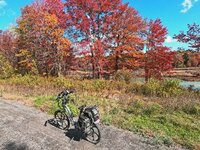
These are yesterday's pics from the D&R which is at the same latitude as Pine Creek:
GOPR0205b.jpg GOPR0206b.jpg GOPR0207b.jpg P1080513b.jpg
In years past, the foliage change here has been roughly the same as Pine Creek. This can vary however. The color next week will depend on how much wind & rain we get from hurricane Delta.

If the forecast holds, I'm planning on heading out there Tuesday thru Friday in the hopes of getting a few pics before the color fades completely. Currently, Wednesday looks like the best day.
 
I rode the D&H Trail in northern Wayne County yesterday and met a fellow rider who was up at Pine Creek on Wednesday, 10/7. FWIW, he said the color was peaking on the ridge tops and near peak in the lower gorge.

These are yesterday's pics from the D&R which is at the same latitude as Pine Creek:
View attachment 68177 View attachment 68178 View attachment 68179 View attachment 68180
In years past, the foliage change here has been roughly the same as Pine Creek. This can vary however. The color next week will depend on how much wind & rain we get from hurricane Delta.

If the forecast holds, I'm planning on heading out there Tuesday thru Friday in the hopes of getting a few pics before the color fades completely. Currently, Wednesday looks like the best day.

You mentioned the best single day ride at the Pine Creek was from Darling Run down to Slate Run and back for a total of 53 miles.

For a half-day ride, would you recommend going from Darling Run east towards Wellsboro Junction and back, or from Slate Run south towards Jersey Shore and back?

Not sure what the most scenic parts are.

Thank you
Darling Run to Wellsboro Jct is above the gorge and not as scenic as the gorge itself. Slate Run toward Jersey Shore is below the main part of the gorge. Although there are some scenic spots, this section is more developed with a lot of road crossings. IMO, the best half day ride you can do is Darling run down to Blackwell Mills & back for a total distance of 33 miles. This is the deepest, most remote and most scenic section of the Pine Creek Gorge trail. There are no other public access points between Darling Run and Blackwell except the private camp at Tiadaghton but that is members only.

With a few stops to take in the scenery, this run takes about 3 - 3.5 hours. With any luck, you should be able to get the ride in on Thursday morning before the afternoon rain.
 
I have a rare 6-day weekend coming up next week from 10/23-10/28. I was planning on going for a biking trip. Trouble is, I am not sure where to go!

I would like to drive to a good destination for biking. I would go up to about 300 miles (or less) from the northeast philadelphia area. Maybe a nice national park, or a top trail. I am not sure.

Do you guys have any suggestions for good "destination" locations in the area? I would love to follow the fall foliage southward, though I am not familiar with the area south of Philly at all. I've never been south of DC.

I was thinking possibly Acadia Park in Maine, though at a 550 mile drive from Philly, I think that is more than I can handle in a single-day drive!
 
How far for you to the blue ridge parkway ? Its 30 mph roads not trails but I'd love to bike some of it. Search the trails thread for some mentions.
 
Back