Pennsylvania Rides | Meetups | Pennsylvania Riders

I couldn't resist the great weather last week and took a 4 day trip back down to Cumberland MD. to ride the C&O, GAP and WMRT trails. Not much fall color left but there was still some to be seen.

Up on Big Savage Mountain:
View attachment 69793 View attachment 69794 View attachment 69795 View attachment 69798 View attachment 69799

Mile 186 on the C&O where it joins the GAP trail in Cumberland:
View attachment 69797 View attachment 69796

The Keystone and Salisbury viaducts:
View attachment 69800 View attachment 69801

Pinkerton high bridge with the Pinkerton Tunnel in the background:
View attachment 69802

With most of the leaves gone, good views of the river between Confluence & Ohiopyle:
View attachment 69803 View attachment 69806

Crowded for a weekday at Ohiopyle:
View attachment 69804 View attachment 69805

Great pictures, thanks. I am planning a three night trip next Tuesday through Thursday, driving in from NE Philly on Tuesday, then back friday morning. I was thinking of doing the WMRT and the C&O, and/or anything else in the general area that I may not be aware of. I already did the GAP trail and the Pine Creek trail this season, thanks to yours @6zfshdb and @J.R. very helpful planning advice. This sadly looks like my "last bike trip" of the season.

What would you suggest for an ideal itinerary, weather permitting? You mentioned the WMRT and the C&O as the best in the area, though I am happy to drive a bit further if there are better fish out there. I thought about the Blue Ridge trail, but am not comfortable biking on the road.

Thanks and cheers for the pics.
When I ride the WMRT, I usually follow the itinerary outlined in post #139 of this thread. The WMRT, C&O and possibly the Pike 2 bike will easily keep you busy on a 3 or 4 day trip. In lieu of riding the entire C&O, there are many sections that are worth riding individually. The Big Slackwater section mentioned in post #139 is a must see IMO. Second best is the piece of the C&O between Little Orleans and the Paw Paw Tunnel.

Since the WMRT closely parallels the C&O, there are many possible "loop" rides where you ride out on the C&O, cross over and ride back on the WMRT. I find the paved WMRT to be something of a relief after riding 20 or more rough miles on the C&O. There are a dozen or more possibilities for this type of ride. I can give you specifics if you're interested.

The Blue Ridge Parkway is a ride I've been wanting to do for many years. Like you, I'm concerned about traffic. The road is narrow with no shoulders in spots and people drive too fast. Distractions from cell phones and the beautiful scenery are a recipe for disaster IMO. There was some talk about closing the Parkway to vehicle traffic on one day each year but it never materialized. Instead, there is now a proposal to ban cycling completely: https://www.blueridgeoutdoors.com/go-outside/blue-ridge-parkway-closed-to-cyclists/

I'd love to use the upcoming stretch of good weather to take another multi day riding trip but I've got too much to do at home. With any luck, I'll get out for a single day ride at Lehigh Gorge. This time last year, I was out on Cape Cod riding their great trail system. Hopefully, I'll get back there next spring.
 
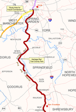
York County PA Heritage Rail Trail.

If you have the time and the weather cooperates it's a really nice ride this time of year. From Hanover Junction south to New Freedom I call it the Christmas Trail. From mid November to Christmas: Northern Central Railway of York, York County Parks and the Rail Trail Authority have many events planned, like the Tannenbaum Christmas Tree Train.

20161125_151419.jpg


You can board the train in New Freedom and ride to a tree farm in Seitzville to cut your own tree. They then will transport your tree back and have it waiting for your return.

20201107_150555.jpg


20161125_151551.jpg


If you're lucky you can see Santa, he's setup a workshop at the old flour mill in Seitzville.

20201107_150903.jpg


20201121_123844.jpg


20201121_173133.jpg


If you look closely you can see Prancer playing Reindeer games on the trail.

20201123_102424.jpg


Event calendar.

20161125_155356.jpg


Of course you can see all for free from the saddle of your ebike. Be careful of the world famous guard turkeys! They are particularly mean this time of year. I can't imagine why?!

20201121_124121_1605985153970.jpeg


Look for the monument to the Glen Rock Carolers from the trail. For 173 years they have walked through the town on Christmas Eve, in their wool coats and top hats, singing Christmas carols.

1217glenrockcarolersstatue.jpg


Have a safe and happy holiday season. Happy Thanksgiving, Merry Christmas and happy holidays to all.

heritagerailtrail.gif
 
Last edited:
For anyone interested, Public Television is re-airing "The Great Ride". It's a 1 hour documentary made by a group who rode from Washington DC to Pittsburgh on the C&O Canal and Great Allegheny Passage trails. I saw it last year when it was first aired and it's well worth the time if you are interested in either of these trails.

For those in the Scranton viewing area, It is airing on Friday, 1/8 from 1 - 2 PM on WVIA. Other viewing times & channels can be found here by entering your zip code:

https://www.aptonline.org/catalog/GREAT-RIDE-THE
It's very well done.

 
I couldn't resist the great weather last week and took a 4 day trip back down to Cumberland MD. to ride the C&O, GAP and WMRT trails. Not much fall color left but there was still some to be seen.

Up on Big Savage Mountain:
View attachment 69793 View attachment 69794 View attachment 69795 View attachment 69798 View attachment 69799

Mile 186 on the C&O where it joins the GAP trail in Cumberland:
View attachment 69797 View attachment 69796

The Keystone and Salisbury viaducts:
View attachment 69800 View attachment 69801

Pinkerton high bridge with the Pinkerton Tunnel in the background:
View attachment 69802

With most of the leaves gone, good views of the river between Confluence & Ohiopyle:
View attachment 69803 View attachment 69806

Crowded for a weekday at Ohiopyle:
View attachment 69804 View attachment 69805

With the nice weather this upcoming week, I was also thinking of taking a mid-week trip down to Western Maryland area to ride the GAP trail, C&O, and/or WMRT. I was wondering what you thought the conditions would be like at this time of year, and how to best allocate the time.

Realistically I would leave from NE Philly on Tue or Wed morning (most likely Wednesday), and return home first thing Friday morning.

I rode the GAP trail in the fall. Have not yet seen the C&O or WMRT. Not sure if the trails are clear from snow/winter debris yet.

Where would you recommend I stay for a short trip, that is friendly for bringing my bike inside the hotel room? What would your suggested itinerary be?

Getting a quick taste of spring this week, need to make the most of it!
In central PA we had storm after storm this year. Our Heritage Rail Trail still has a lot of snow where it doesn't get all day direct sun. So many of our trails are in valleys along creeks and rivers where railroads were built and they often do not get a lot of sun this time of year. I've seen snow here on the trails until Easter some years.

This was the first day of spring in 2015 on the Heritage Rail Trail:

Screenshot_20160930-183923.png

Maybe the C&O at Harper's Ferry and south would be a safe bet for no snow on the trail.
 
With the nice weather this upcoming week, I was also thinking of taking a mid-week trip down to Western Maryland area to ride the GAP trail, C&O, and/or WMRT. I was wondering what you thought the conditions would be like at this time of year, and how to best allocate the time.

Realistically I would leave from NE Philly on Tue or Wed morning (most likely Wednesday), and return home first thing Friday morning.

I rode the GAP trail in the fall. Have not yet seen the C&O or WMRT. Not sure if the trails are clear from snow/winter debris yet.

Where would you recommend I stay for a short trip, that is friendly for bringing my bike inside the hotel room? What would your suggested itinerary be?

Getting a quick taste of spring this week, need to make the most of it!

As J.R. says, we've had a lot of snow this winter. During early season, I usually try calling the Hancock MD. Tourism Center: (301) 678-5622
You may get a recording if no one is in the office. Hancock is at the center of the WMRT and also a major junction with the C&O. Someone there should be able to give you current trail conditions.

You can also try calling the C&O Canal headquarters in Hagerstown: 301-739-4200
They may not have information on the WMRT though.

My guess is there will be heavily shaded areas on both trails with snow & ice patches this time of year.

My favorite place to stay in that area is the Holiday Inn Express in Clear Spring. They had no problem with bikes in the room the last time I was there. A first floor room is best so you don't have to hassle with the elevator. They have a great hot tub and heated indoor pool. It's a really nice place to defrost after a cold ride. The hotel is a 5 minute drive from the Big Pool trailhead at the eastern end of the WMRT. It's also a 10 minute drive from the Williamsport trailhead and visitor center on the C&O.

I can send you GPS coordinates if you're interested.

Thanks a lot @6zfshdb and @J.R.

Seems my best bet for this week is to stick to my local trail - the D&L canal towpath.

The stretch from Washington Crossing PA up to the Nockamixon Cliffs is a great ride, and worth the trip!
 
Thanks a lot @6zfshdb and @J.R.

Seems my best bet for this week is to stick to my local trail - the D&L canal towpath.

The stretch from Washington Crossing PA up to the Nockamixon Cliffs is a great ride, and worth the trip!
I ride that stretch of the D&L a couple of times a year myself. It is indeed a good ride. Lots of historical sights along the way.
I usually start at Tinicum Park, just south of the cliffs, and ride down to Washington Crossing. I cross the Delaware and ride the D&R Trail on the Jersey side up to Frenchtown, then back across the river to Tinicum. Makes for a good 40 mile loop ride.
 
For all you PA rail trail riders I have a question. I have seen these concrete pylons (pieces of railroad infrastructure) in several places around the state. I don't believe I've seen them in other states, but I could be wrong. What are they? What were they for?

20170429_144718.jpg


20170429_144735.jpg


20170429_151307.jpg


These examples are from Stony Valley. And no, there isn't a YMCA nearby;) and it's not the PA Keystone... Curious minds want to know (of course it might be just me). They are made from that large aggregate concrete one typically sees from the 1920's and 30's.
 
They are for storing extra ties for repairs to the tracks!
I appreciate the suggestion, but there are many singles and the two near one another in the photo above are at least 10 to 12 feet apart. They stand about 30 or so inches above the ground and are no more than 24 inches wide. Anytime I've seen trackside tie storage in photos there are dozens of ties stacked up. I've tried many times over the years to find pictures of these pylons in use, but have struck out.
 
I appreciate the suggestion, but there are many singles and the two near one another in the photo above are at least 10 to 12 feet apart. They stand about 30 or so inches above the ground and are no more than 24 inches wide. Anytime I've seen trackside tie storage in photos there are dozens of ties stacked up. I've tried many times over the years to find pictures of these pylons in use, but have struck out.

Let me correct my answer. They were to hold sections of metal track, not wooden ties. Groups of these were spaced out every couple of miles to store 30 foot sections of track in areas that were hard to reach when repairs were needed. I researched this years ago, as I was also curious about them. I would imagine many of them have disintegrated ot have gone home with people.
I believe there might be some info on them on the Stony Valley facebook page.
Track! That makes sense, especially on Stony Valley. Apparently that was one of the most remote and toughest places for a railroad, when it was built. It hard to believe that entire area was stripped clean from clear cutting. An ecological disaster area. I've seen pictures of it and it looked like it was carpet bomber. Now it's one of the prettiest places to hike and bike. April the spruce and hemlock explode with the most intense scent. And then the rhododendron and mountain laurel bloom. Great place to ride.
 
Track! That makes sense, especially on Stony Valley. Apparently that was one of the most remote and toughest places for a railroad, when it was built. It hard to believe that entire area was stripped clean from clear cutting. An ecological disaster area. I've seen pictures of it and it looked like it was carpet bomber. Now it's one of the prettiest places to hike and bike. April the spruce and hemlock explode with the most intense scent. And then the rhododendron and mountain laurel bloom. Great place to ride.
I've seen these "3 headed" concrete fixtures along rail trails in many locations, mostly in PA. The only location I can remember specifically is on the upper section of the Black Diamond Trail near White Haven, PA. It's on an old abandoned ROW parallel to the one used for the Black Diamond Trail itself. This one, along with most others I've encountered, are single fixture installations. IMO, these are standard concrete fixtures used for a variety of purposes. Track storage is certainly one possibility but the ones you show seem to be too close together for that purpose. Standard rail sections are 40' in length and would be too long for that spacing. It is possible that one or more have been removed though.

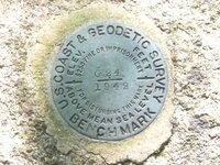
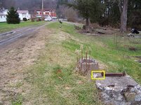
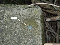
Many of these old concrete railroad structures were left in place because they were used as a mounting bases for US Coast & Geodetic "Benchmarks". Most are bronze disks but some can be as small as a copper rivet:
G24-KV1330-1-24082011.JPG JX0245.jpg 18-KV1696-1-30JUNE10.JPG JX0284.jpg

Mostly, these benchmarks are set into more permanent structures like bridge abutments and building foundations. When no such structures are available, less stable mountings were used such as these railroad concrete castings.
 
I've seen these "3 headed" concrete fixtures along rail trails in many locations, mostly in PA. The only location I can remember specifically is on the upper section of the Black Diamond Trail near White Haven, PA. It's on an old abandoned ROW parallel to the one used for the Black Diamond Trail itself. This one, along with most others I've encountered, are single fixture installations. IMO, these are standard concrete fixtures used for a variety of purposes. Track storage is certainly one possibility but the ones you show seem to be too close together for that purpose. Standard rail sections are 40' in length and would be too long for that spacing. It is possible that one or more have been removed though.

Many of these old concrete railroad structures were left in place because they were used as a mounting bases for US Coast & Geodetic "Benchmarks". Most are bronze disks but some can be as small as a copper rivet:
View attachment 81077 View attachment 81078 View attachment 81076 View attachment 81079

Mostly, these benchmarks are set into more permanent structures like bridge abutments and building foundations. When no such structures are available, less stable mountings were used such as these railroad concrete castings.

What is that black diamond trail like?

I have ridden the lehigh gorge state park from Jim Thorpe to White Haven many times, but not ventured further North than White Haven. Is the Black Diamond trail in good condition? Does it go all the way to Wilkes Barre?
 
What is that black diamond trail like?

I have ridden the lehigh gorge state park from Jim Thorpe to White Haven many times, but not ventured further North than White Haven. Is the Black Diamond trail in good condition? Does it go all the way to Wilkes Barre?
The Black Diamond is actually the norther section of the Delaware & Lehigh (D&L) Trail which also includes the Lehigh Gorge Trail. It will eventually run north from White Haven to Mountain Top but there are sections missing. This website is current as of 2/21. If you click on the various trail sections, it will give you a description:

To get to the Black Diamond from the Lehigh Gorge White Haven trailhead, you have to ride about a quarter mile on city streets.

The first mile north of White haven up to Middleburg Rd has not yet been improved but it is easily ride-able if you avoid the potholes.

North of Middleburg Rd, There is an excellent 10 mile section open up to the Black Diamond Trailhead in Glen Summit. It is similar in condition to the Lehigh Gorge trail but is much less popular.

North of Glen Summit, there is a 4 mile undeveloped section up to Lake Road which is privately owned. From Lake Road, you can ride another 7 miles to the Mountain Top Trailhead but the trail condition is not good and hardly worth taking a detour to get there.

Right now, the Black Diamond isn't worth a trip to ride by itself but I usually include the improved 10 mile section when I'm out riding the Lehigh Gorge trail.
 
Back