Pennsylvania Rides | Meetups | Pennsylvania Riders

Track! That makes sense, especially on Stony Valley. Apparently that was one of the most remote and toughest places for a railroad, when it was built. It hard to believe that entire area was stripped clean from clear cutting. An ecological disaster area. I've seen pictures of it and it looked like it was carpet bomber. Now it's one of the prettiest places to hike and bike. April the spruce and hemlock explode with the most intense scent. And then the rhododendron and mountain laurel bloom. Great place to ride.

How is the condition of the Heritage Rail Trail right now? I am thinking about making a trip down tomorrow to take advantage of this nice weather!
 
How is the condition of the Heritage Rail Trail right now? I am thinking about making a trip down tomorrow to take advantage of this nice weather!
It's in good shape, for the most part it drains really well. The areas that hold snow and ice the longest due to shade are from the tunnel, south to Glatfelter Station Rd and Glen Rock, south to the town of Railroad. Sections of snow and mud, but passable. Haven't seen it this week. If my schedule permitted I'd be riding today and tomorrow. Enjoy!
 
The Black Diamond is actually the norther section of the Delaware & Lehigh (D&L) Trail which also includes the Lehigh Gorge Trail. It will eventually run north from White Haven to Mountain Top but there are sections missing. This website is current as of 2/21. If you click on the various trail sections, it will give you a description:

To get to the Black Diamond from the Lehigh Gorge White Haven trailhead, you have to ride about a quarter mile on city streets.

The first mile north of White haven up to Middleburg Rd has not yet been improved but it is easily ride-able if you avoid the potholes.

North of Middleburg Rd, There is an excellent 10 mile section open up to the Black Diamond Trailhead in Glen Summit. It is similar in condition to the Lehigh Gorge trail but is much less popular.

North of Glen Summit, there is a 4 mile undeveloped section up to Lake Road which is privately owned. From Lake Road, you can ride another 7 miles to the Mountain Top Trailhead but the trail condition is not good and hardly worth taking a detour to get there.

Right now, the Black Diamond isn't worth a trip to ride by itself but I usually include the improved 10 mile section when I'm out riding the Lehigh Gorge trail.

Was thinking of going up to lehigh gorge tomorrow.

Last time I rode north from white haven, i went up the ubdeveloped road you mentioned for a few minutes, then turned around because it was bumpy and the view of the woods was boring.

Does the trail condition and scenery improve as you head north?
 
Was thinking of going up to lehigh gorge tomorrow.

Last time I rode north from white haven, i went up the ubdeveloped road you mentioned for a few minutes, then turned around because it was bumpy and the view of the woods was boring.

Does the trail condition and scenery improve as you head north?
Yes, once you cross Middleburg Rd., 1.5 miles north of White Haven, the trail surface improves greatly. I can't say the view of the woods changes much though.
 
I took advantage of the fine spring weather earlier this week and headed out to ride the WMRT and GAP Trails. I usually try to time my first visit out there to coincide with the Redbud bloom and caught the peak:

64114182593b.jpg
IMG_0977b.jpg
IMG_0970b.jpg


During every trip out there, I hear the locals talk about the possible extension of the WMRT out to Paw Paw WV. So far, talk is all it is with no evidence of any work going on at the existing Western terminus:

IMG_0975b.jpg


Considering the good weather, there were very few riders on the WMRT and GAP trails. The normally popular places like downtown Cumberland, the Salisbury Viaduct, and the Mason Dixon Line Park were all but deserted:
IMG_0959b.jpg
IMG_0960b.jpg
IMG_0985b.jpg

IMG_0979b.jpg
IMG_0980b.jpg
IMG_0990b.jpg


Something new on the lower portion of the GAP near Cumberland is a Maple syrup farm. Apparently, they have permission to use the trail to access their bulk syrup tanks:

IMG_0966b.jpg
IMG_0967b.jpg


I'm waiting for the next stretch of good weather to head out to Clarion in northwestern PA. The Allegheny River, Redbank Creek, Sandy Creek, Oil Creek and Armstrong trails are all great rides. A 12 mile paved extension was recently added to the Rail 66 Trail. It's now over 26 miles in length and I'm looking forward to checking it out.
 
Last edited:
Not much recent activity in this thread. I'd hate to see it die since PA. is my home state.

I made my usual fall trip down to Western Maryland to ride the WMRT. Not much has changed since my spring trip above.

P1090170b.jpg


There was some talk at C&O Bicycle in Hancock about progress on the proposed extension of the WMRT out to Paw Paw WVA.
No construction activity at the western end was obvious but I did see surveyors working the area.


P1090175b.jpg
P1090173b.jpg


A tree came down across the C&O access ramp during hurricane Ida the previous week. No damage to the ramp but you need to lay your bike over to get under it. There is some question as to who is responsible for it's removal. The locals say it's a dispute between the feds who maintain the C&O Canal Trail and the WMRT. The tree was growing in the old canal bed on federal property but it fell across the ramp located on land maintained by the Maryland Parks Service. It will be interesting to see how long it takes to clean up.

P1090176b.jpg
P1090178b.jpg
 
I have a battery Stihl chainsaw. It would be easy to pack along and quiet. Would anyone complain if that tree’s lower branches “just fell” off that access ramp?
A tree came down across the C&O access ramp during hurricane Ida the previous week. No damage to the ramp but you need to lay your bike over to get under it. There is some question as to who is responsible for it's removal. The locals say it's a dispute between the feds who maintain the C&O Canal Trail and the WMRT. The tree was growing in the old canal bed on federal property but it fell across the ramp located on land maintained by the Maryland Parks Service. It will be interesting to see how long it takes to clean up.

View attachment 100036 View attachment 100037
 
I have a battery Stihl chainsaw. It would be easy to pack along and quiet. Would anyone complain if that tree’s lower branches “just fell” off that access ramp?
I know a guy that walks the local trails I ride, he carries a rope with a grapple hook to pull widowmaker limbs down so they won't fall on cyclists and hikers. The only thing anyone ever says to him is thanks!
 
I have a battery Stihl chainsaw. It would be easy to pack along and quiet. Would anyone complain if that tree’s lower branches “just fell” off that access ramp?
Check out this "trail maintenance" post
 
I have a battery Stihl chainsaw. It would be easy to pack along and quiet. Would anyone complain if that tree’s lower branches “just fell” off that access ramp?
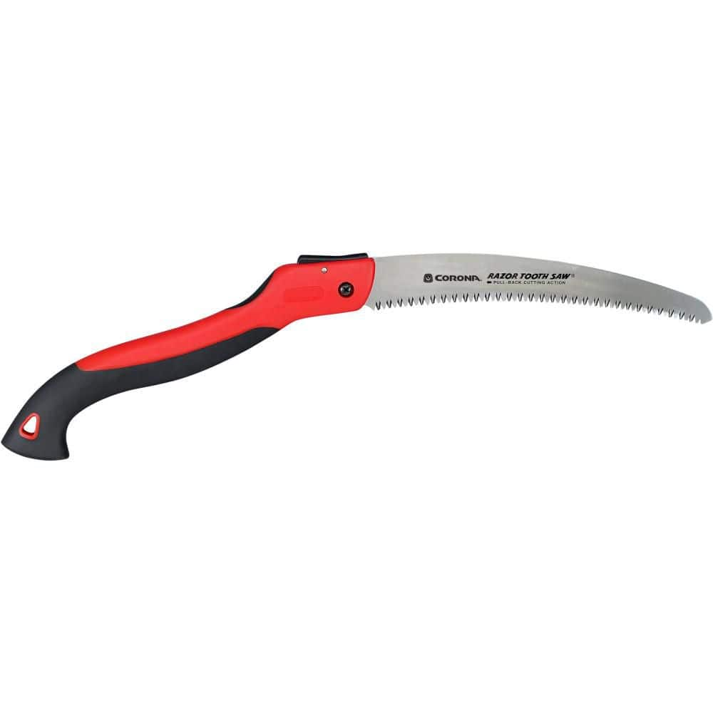
I actually carry a folding hand saw when I ride.


It doesn't look like much but it's sharp as a razor. I've cut several 8" limbs with it.

A few years back, I got boxed in on the GAP trail between Ohiopyle and Confluence by fallen trees during a storm. A fellow rider had a hand saw and we were able to cut our way out. We didn't cut tree trunks, just enough branches & limbs to get the bikes through. I've carried one ever since.

I could have cut that lower limb fairly easily but it wasn't clear where the balance and support points of the tree were. Since I was able to get by, I decided to let it be.
Which access point is this closest to?

I’m heading out to the WMRT Saturday morning with a friend. I’ll throw the Stihl in the trunk just in case. It looks like it would be easy enough to cut the closest limb to the far right, beyond the guard rail, then cut the same limb well to the inside of the left guardrail, so that the tree itself stays hung up on the left guardrail but the path is clear. (I’ve been heating with wood for a long time and have cut much larger trees that were even more hung up. But it is indeed dangerous.)
 
I actually carry a folding hand saw when I ride.


It doesn't look like much but it's sharp as a razor. I've cut several 8" limbs with it.

A few years back, I got boxed in on the GAP trail between Ohiopyle and Confluence by fallen trees during a storm. A fellow rider had a hand saw and we were able to cut our way out. We didn't cut tree trunks, just enough branches & limbs to get the bikes through. I've carried one ever since.

I could have cut that lower limb fairly easily but it wasn't clear where the balance and support points of the tree were. Since I was able to get by, I decided to let it be.
I'll order one for in the van. Any handsaw that actually cuts now a days is a rare and beautiful thing. I gave my chainsaw away b/c I routinely break tools and don't trust myself with a chainsaw. I have to use a skill saw, but I buy my firewood already bucked and split.
 
Which access point is this closest to?

I’m heading out to the WMRT Saturday morning with a friend. I’ll throw the Stihl in the trunk just in case. It looks like it would be easy enough to cut the closest limb to the far right, beyond the guard rail, then cut the same limb well to the inside of the left guardrail, so that the tree itself stays hung up on the left guardrail but the path is clear. (I’ve been heating with wood for a long time and have cut much larger trees that were even more hung up. But it is indeed dangerous.)
It's the western ramp closest to Little Orleans near the west portal of the Indigo Tunnel. It's less than a mile east of the Little Orleans Trailhead. If you park there, you could return the saw to your vehicle rather than haul it with you on the whole ride.

I thought about cutting the same limb you mention but there is another that isn't clearly visible in the pic. Use caution wherever you cut! With any luck, someone else has already taken care of it.
 
I made my usual fall trip out to ride the Pine Creek Trail this week. Not much color yet but it's a bit early.

P1090266b.jpg P1090271b.jpg P1090278b.jpg P1090285b.jpg

I was disappointed to see all the trail damage caused by the heavy rain from hurricane Ida in August. Anyone planning a trip out there this fall should use caution on the section through the gorge from Darling Run to Tiadaghdon. Washouts at Darling Run, Pinafore Run and Stonewall Run left very rough trail surface conditions which aren't readily visible.

P1090274b.jpg P1090234b.jpg

While I was there, someone was thrown from their bike at Stonewall Run and injured severely enough to require a 911 call. A fire rescue vehicle and an ambulance passed me on the way to the scene:

P1090226b.jpg

These are before and after pics of Pinafore Run. I have to give the DCNR credit for performing repairs so quickly. The trail was closed for just 3 days.

image004-2.jpg P1090222b.jpg P1090259b.jpg

The debris flow from Pinafore Run choked off two thirds of the flow of Pine Creek:

P1090229b.jpg

The good news is, 95% of the trail is in good shape. The DCNR resurfacing project is progressing with over half the trail completed. They are using a composite material similar to asphalt millings which packs down into a smooth, durable surface.

P1090251b.jpg
 
Just returned from another trip to Acadia and it was glorious. It has to be the best eBiking destination that I know of in the Northeast. From the town of Bar Harbor, you can easily bike into the park, avoiding the main trafficked roads, and enjoy 45 miles of hilly carriage roads for biking. Return and enjoy cheap delicious seafood.

I'll be going back mid-November, hope that there is no snow by then.
Acadia is indeed a great biking destination! Did you stay at the Hampton Inn again?

I assume you had no issues with your e-bike? Unfortunately, the National Park e-bike laws leave it up to the individual park superintendents to regulate their use on specific trails. You never know from one trip to the next if the regs have changed.

Winters are usually moderate in coastal Maine. It does snow in November but it usually doesn't start to accumulate until mid to late December. November temps average around 45 for a daily high to a low of 30.

We've been fortunate here in the northeast with unseasonably high temps this fall. I just got back from a 5 day trip out to northwestern PA. I rode the Redbank Creek, Armstrong, Allegheny River and Sandy creek trails, mostly wearing just a short sleeved shirt! I'm hoping to get back down to Cumberland, MD. to ride the GAP again next month if the weather holds.

I actually lucked out with the Hampton Inn pricing when I stayed mid-May this year. I booked the hotel in the winter when the country was on covid lockdown for an absurdly low rate of around $100/night. When I went back in September, the hotel was over $500/night - way too much.

I stayed at the bar harbor villager this time, and it was very clean and comfortable for an affordable price.

You can easily access the carriage roads from anywhere in Bar Harbor. You just have to bike along a very short 0.2 mile stretch of the main park loop road.

You can also access the carriage roads from Hulls Cove, Seal Cove, and the Aticou area of Northeast Harbor. When I go back in November, I am going to try and find all the nooks and crannys of how to access the carriage roads from other parts of the island. There is a good restaurant - the chart room - in Hulls Cove, that you can bike along some back trails to get to from Bar Harbor.

Also did some great hiking - I climbed Dorr Mountain, the Beehive, Jesup Trail, and many others.

No problems at all with the eBike. Most people were actually on eBikes. Some of the hills were brutal, even on an eBike! Signs were all over saying class 1 eBikes only.

I learned that the carriage roads are open 24/7 for bikers. On a future trip, probably not this November due to possibility of ice, I will bike the Day Mountain Summit carriage road in the night. Will be great for stargazing.

Honestly I am just going to save all my days off for trips to Acadia. It might just be my favorite place in the US.

Unfortunately Hurricane Ida destroyed my local D&L canal trail in southeast PA. Major (major) bummer.

The Norwegian Rallervegan still holds the #1 bike trail. If covid ever goes away, its somewhere you must go bike.
 
Back