Our Rides in Words, Photos & Videos

Some lovely rides up in the San Juans, too, but you probably know that already 😉.

I have not been there in quite a while. One of my early rides in Washington was to Lopez and there have been a few repeats over the years. Orcas became a semi-regular since there was a conference at Rosario (when it was public) and I'd ride up Mt Constitution. But not in a number of years.

A neat ride a few years back was a Memorial Day loop from Whidbey to Port Townsend, to Port Angeles to Victoria, to Sidney and back to Anacortes.
 
Awww, bummer! I so enjoyed seeing Poland from your perspective!
Don't worry. I'm taking my laptop with me. My brother Jacek has a crazy ride plan for the weekend: To ride 100 miles to his brother-in-law for a party on Friday, and to return (another 100 miles) on Sunday. He will be riding Giant Trance E+ 2 Pro on Johnny Watts tyres and on a single battery each way (the charger taken with him). That will be story I like to tell you! :)
 
Don't worry. I'm taking my laptop with me. My brother Jacek has a crazy ride plan for the weekend: To ride 100 miles to his brother-in-law for a party on Friday, and to return (another 100 miles) on Sunday. He will be riding Giant Trance E+ 2 Pro on Johnny Watts tyres and on a single battery each way (the charger taken with him). That will be story I like to tell you! :)
Maybe one day you can ride over to the western Polish border, and tell me about where my parents came from. Oh, probably not, it's like 25 hours by bike! I don't imagine you're ready for a 500km bike ride, one way! 🤣

Screen Shot 2022-05-17 at 4.19.37 PM.png

🤣
 
Maybe one day you can ride over to the western Polish border, and tell me about where my parents came from. Oh, probably not, it's like 25 hours by bike! I don't imagine you're ready for a 500km bike ride, one way! 🤣

View attachment 123597
🤣
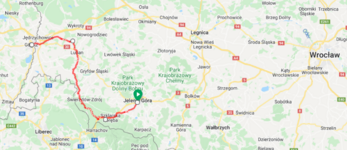
It makes no historical sense to ride from Warsaw to Zgorzelec (Goerlitz). It makes, however, great sense to ride from Jelenia Góra/Hirschberg to Goerlitz. All the area used to be German before the WWII.
1652823797544.png

I've already been to Jelenia Góra, Szklarska Poręba and Świeradów-Zdrój. The ride is less than 70 miles with 4,200 ft of elevation gain. An easy cake :)
 

Attachments

  • 1652823756481.png
    1652823756481.png
    586.8 KB · Views: 113
It makes no historical sense to ride from Warsaw to Zgorzelec (Goerlitz). It makes, however, great sense to ride from Jelenia Góra/Hirschberg to Goerlitz. All the area used to be German before the WWII.
View attachment 123610
I've already been to Jelenia Góra, Szklarska Poręba and Świeradów-Zdrój. The ride is less than 70 miles with 4,200 ft of elevation gain. An easy cake :)
Ah, Old Germany... I shall await any stories you might have! 😉
 
My friend came out from Richmond, Va in his first exposure to an ebike though I have bored him about the subject often. He rode my new medium frame Allant 7s with the grips and seat upgraded. In a nutshell "the ride exceeded my high expectations" he said. He rides a conventual bike short distances to the James river from a few blocks away. Even short distances elicited hand numbness. On the Trek for our 16 miles (the distance impressed him) the numbness didn't show up. He thought the bar-ends and the cork grips helped a lot. I pointed to the large lower pressure tires and front shocks as contributing. He'll be back.
Nightmare Bugs Bunny surveys Echo Meadow which is an eerie scene in the early morning mists.
IMG_0858.JPG

IMG_0861.JPG
 
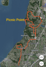
Picnic  Point  x2
As expected Sunday was socked in with rain to the point where you can barely tell where the water and clouds meet when looking out on the Sound.

Unexpectedly, after family brunch I spotted a little patch of sky while in the car with my girl. So we drove up to what had been on my planned route- Picnic Point: a small beach park about halfway between the Edmonds and Mukilteo ferries. My daughter and I had a rare 1/2 hour walk along the water edge and just talked in the unexpected sun.
PXL_20220515_211511907.jpg


By the time we got home it was raining again. Lo and behold, about 6:15 the rain finally stopped so I had about 2 hours for a ride. Back up to Picnic Point which is a fun descent and then a good climb back up from the water.
PXL_20220516_023008660~2.jpg

I tarried too long, and could see the next front moving up from the south. This picture is looking due west.

PXL_20220516_024726372-EFFECTS.jpg

Sure enough, most of the ride home was in the dark and in the rain. Was hoping to make 30 miles but ended up at 28 with 1800ft of climbing. Still a good day, and the sun shone when I needed it the most.
 

Attachments

  • PXL_20220515_211344667.jpg
    PXL_20220515_211344667.jpg
    752.3 KB · Views: 115
  • PXL_20220516_023035174.jpg
    PXL_20220516_023035174.jpg
    818.5 KB · Views: 121
  • PXL_20220516_023329398~2.jpg
    PXL_20220516_023329398~2.jpg
    587.5 KB · Views: 113
  • PXL_20220516_023646100.jpg
    PXL_20220516_023646100.jpg
    820.3 KB · Views: 111
  • Screenshot_20220516-022735.png
    Screenshot_20220516-022735.png
    1.7 MB · Views: 125
  • PXL_20220516_022602150.jpg
    PXL_20220516_022602150.jpg
    566.4 KB · Views: 126
A neat ride a few years back was a Memorial Day loop from Whidbey to Port Townsend, to Port Angeles to Victoria, to Sidney and back to Anacortes.
Oh, that sounds like a long but good ride. I have a similar but less far ranging ride mapped out using the Edmonds, Port Townsend, and Mukilteo ferries. A little over 100 miles before subtracting out the ferry miles. Maybe this summer on a random weekday if I take off work.
 
Mystery Resolved...

Can you remember this picture from my older post?

1652850136080.png

I wanted to keep it a military secret. It is not a military secret, though :)

1652850467420.png

"This is how you do it. The Americans mock the Russian and show a bridge near Dęblin".
"U.S. soldiers have no mercy on Russians. They show how a professional Army does a river crossing".


It turns out I wandered to the Defender Europe 22 military exercise site :)
One of the stages of the Defender Europe 22 exercise is to overcome a wide water obstacle. On the Vistula near Dęblin, the crossing was organized on two axes, on the first axis a pontoon bridge was laid by Polish engineering troops, and on the second axis an American ferry crossing was organized - it was announced a few days ago on the official Facebook manoeuvres' profile.

The aforementioned bridge was used by the Americans to ridicule the Russian army. The Russians are ineptly trying to overcome the Donets River. Fortunately, the Ukrainian forces are destroying the pontoon bridge that is being built anew.

This is where the Americans come in. They posted a photo of the bridge from Dęblin on the web and described the situation unequivocally.
 
Last edited:
The Art of Outracing The Rain (with apologies to Garth Stein)

My day didn't involve a Golden Retriever, a sports car and a tragic storyline. All well and good when you are writing a best seller, but in my case my day was written as a simple blog entry involving a fast bike, a fast moving pursuit of nasty rain clouds, and 24 miles in which to figure out who will win.

(Hint: I did, but only by a nose)

I hadn't been able to ride my bike near as much as I needed due to an endless array of excuses. Some valid, most not. But I have a charity bike ride looming on the weekend horizon, and I am desperately in need of some cycle time to tell me if I should do the half century ride I'm signed up for, or switch to the family fun 20 mile ride that is less strenuous, doesn't require me to carry my extra battery because the lesser distance doesn't have of the endless hills of the century/half century, and has some great views in an area I've yet to see.

Today I had 2 hours to give myself for a ride. Before I pulled my bike from the garage and pumped the tires, a glance at the immense towering stacks of cumulous nimbus clouds crowding the depressingly humid skies suggested a glance at the radar might also be a good idea. Areas to the south and west were huddled under some heavy rain storms, but my area was still showing bits of blue sky. A fast 25 miles promised to get me around the block and home before I got any wetter than just my own sweat.
View attachment 123331
I took off on the Class 3 for my favorite paved road loop into the county below. Being mid afternoon there was little traffic asking to share the road and so the vistas and countryside was mine alone to ride, photograph, and enjoy.
View attachment 123343

Most of my route would follow the line of the Blue Ridge where the footpath of the 2,000+ mile long Appalachian Trail threaded the crest heading north to Maine and south to Georgia. Lately I've been reading the blogs of several through "nobo" hikers ("northbound" abbreviated in their unique lingo), enjoying their daily ramblings (both physical and written). It was amazing to me how so many could find such a plethora of unique adjectives day after day to describe what amounted to the exact same walk over the same type of terrain day after day. Rather like a bike ride over the same types of roads. How many times can you say the same thing and still keep it fresh? How many times can you eleoquat one foot after another stepping over a rocky trail, or pushing a bike pedal around and around, before there are no more words to describe it differently.

I found we do the same thing, those many solitary people that were hiking the crest of the mountains to my side while I biked the roads a thousand feet below them. We looked at the clouds. We watched our path, our route for potholes and tripping hazards. We greeted fellow travelers along the way be they nobo or sobo. They at least stopped to chat or fell into step for a while along the way. I remained solo, exchanging quick greetings with any other cyclist along the way. And all of us together attempted to outrace the incoming rain. They, at least, had dawn to dusk to walk their average distance of 25 miles of trail, and numerous trail shelters to use should the weather become nasty. I only had speed, wheels, and 2 hours.

View attachment 123339

Still I did take time to photograph, and also take a quick detour to stop in at a cemetery enroute in Upperville and bring a sprig of flowers to lay on the stone of an old endurance riding friend, reflecting on our years together riding and training our horses on that same mountain that is the keystone of the hiking blogs.
View attachment 123345

I noticed that one of the old dwellings in the town had been honored with a sign, which looked quite nice and certainly dressed the old building with a nod to its historic past. The town is comprised of old historic buildings. Nothing new as there is no room to build, and every inhabitant takes pride in owning and maintaining the centuries old dwellings that exist within the confines of those narrow town lines.
View attachment 123344

As I tucked my camera away I noticed the clouds closing in from the west and south had gained more troops, many threatening severe rains. I glanced at the radar and saw with growing alarm that my time was running out. For sure the hikers along the trail at the top of the mountain had already taken refuge as the rains had reached there sooner and were viciously pounded the summit. The valley below where I stood was the next target. It was time to go.

View attachment 123342

I had two choices. One - take the highway out of town and do all paved roads to home, or Two - take the shorter route via a local gravel road and hopefully be home quicker. I chose option Number Two and booked it, so to speak. Within 5 miles from home I felt the first drops of rain. It was a warning. A threat almost. The crest of the Blue Ridge was enveloped in a downpour, rendering half of the mountain invisible. I wondered about those hiking the trail, and hoped they were huddled in shelters safe from the storm. As for me, I pushed both the bike and myself to the 28mph limit. The pavement flew under my wheels as I endeavored to outpace the rains thundering up behind me. But I ran out of steam within 2 miles and had to back down the speed, disgusted at myself for being so unfit.

Not all for naught, however. I'd given myself enough of a head start to be just out of range of the exploding storm at my heels. The final 3 miles flew under my feet and I was up the driveway and home before the first serious drops fell. A victory, albeit a close shave.

I will enjoy the hiking blogs as we compare our separate 25 mile "outracing the rain" stories, those atop the mountain on the narrow rocky trail, and mine below on the smooth paved road. And maybe today I'll be out again cycling on the road, just as those hikers will be on the trail. They have 2,000 miles to cover in their quest. I, on the other hand, simply have a ride this weekend. 20 or 50 miles. Still hard to decide which. Still a toss up. For now.

More rains forecast today, worse than yesterday. Lots of "severe weather" warnings already popping up on my phone and tablet.

Guess I'll have to lay out some strategy for this next ride if I want to outrace the rains again.
A friend and I were going to come iver to do part if the Appalachian trail, after he read the opening paragraph from Bill Brysons book.

Not long after I moved with my family to a small town in New Hampshire I happened upon a path that vanished into a wood on the edge of town. A sign announced that this was no ordinary footpath but the celebrated Appalachian Trail. Running more than 2,100 miles along America's eastern seaboard, through the serene and beckoning Appalachian Mountains, the AT is the granddaddy of long hikes. From Georgia to Maine, it wanders across founeen states, through plump, comely hills whose very names—Blue Ridge, Smokies, Cumberlands, Green Mountains, Whim Mountains—seem an Invitation to amble. Who could say the words “Great Smoky Mountains" or "Shenandoah Valley" and not feel an urge, as the naturalist John Muir once put it, to "throw a loaf of bread and a pound of tea in an old sack and jump over the back fence"?
We never did it though 🙁
 
Mystery Resolved...

Can you remember this picture from my older post?

View attachment 123654
I wanted to keep it a military secret. It is not a military secret, though :)

View attachment 123655
"This is how you do it. The Americans mock the Russian and show a bridge near Dęblin".
"U.S. soldiers have no mercy on Russians. They show how a professional Army does a river crossing".


It turns out I wandered to the Defender Europe 22 military exercise site :)
Whats that, traffic wardens marine division?
 
Great to be riding semi-regularly again, just in time for the temperatures to start becoming an issue here in the Piedmont Triad of North Carolina!

Sunday, we rode 9.4 miles, two of them mistakenly recorded as walking on my gps app. I thought it defaulted to last active setting when turned on, but I was wrong 😱! Fortunately, there's a nice voice that tells me how far I've gone and how long it's taken, in one mile increments. The second time she announced my progress, I noticed she said "walking", instead of "cycling." Fixed that ...

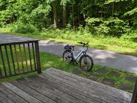
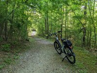
We were on the usual Bicentennial Greenway trail, heading south. Stopped at our favorite creekside deck for the bike shot:

PXL_20220515_152216390.jpg

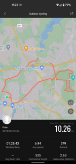
This morning, we rode 10.26 miles the other direction. Combination of the Bicentennial Greenway, Guilford Courthouse National Military Park, Country Park (which is really in the city so I don't get the name), and hateiest stroadside sidewalk riding.

Screenshot_20220518-112227.png

PXL_20220518_133753028.jpg

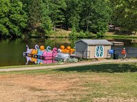
Country Park was kind of run down several years ago when we first arrived here, but the city has been working to spruce it up. The road through the park has been permanently closed to cars and trucks (YAY!), there's a lovely new carousel, and a zip line across the lake is set to open in a couple of weeks (staff was testing it out this morning). There's also a nice, paved connection trail between the two park loops (Country, and the Military Park) open at last. Oh, and they've got pedal boats.

PXL_20220518_141642307.jpg

We were there Sunday afternoon with our grandkiddos. They've got some nice new boats - the old ones were pretty rough! PM and grandson started out pedaling, then granddaughter wanted a turn, and took over the second set of pedals. PM thought I should also "participate", but the kids weren't having it. "Yiya (Greek-ish for grandmother) doesn't get a turn," they shouted in unison! Fine with me, I just sat back and enjoyed the ride 🤣.

Back to today... We took the connector back to the Military Park to complete that loop, then rode the rest of the way home on the sidewalk adjacent to the busy stroad. I always hate that part of the ride, but it's the only option to complete the circuit. Oh well, I can list being grateful we made it back alive in my journal this evening 🤪.
 
Last edited:
Great to be riding semi-regularly again, just in time for the temperatures to start becoming an issue here in the Piedmont Triad of North Carolina!

Sunday, we rode 9.4 miles, two of them mistakenly recorded as walking on my gps app. I thought it defaulted to last active setting when turned on, but I was wrong 😱! Fortunately, there's a nice voice that tells me how far I've gone and how long it's taken, in one mile increments. The second time she announced my progress, I noticed she said "walking", instead of "cycling." Fixed that ...

We were on the usual Bicentennial Greenway trail, heading south.

View attachment 123680

This morning, we rode 10.26 miles the other direction. Combination of the Bicentennial Greenway, Guilford Courthouse National Military Park, Country Park (which is really in the city so I don't get the name), and hateiest stroadside sidewalk riding.

View attachment 123682

View attachment 123683

Country Park was kind of run down several years ago when we first arrived here, but the city has been working to spruce it up. The road through the park has been permanently closed to cars and trucks (YAY!), there's a lovely new carousel, and a zip line across the lake is set to open in a couple of weeks (staff was testing it out this morning). There's also a nice, paved connection trail between the two park loops (Country, and the Military Park) open at last. Oh, and they've got pedal boats.

View attachment 123684

We were there Sunday afternoon with our grandkiddos. They've got some nice new boats - the old ones were pretty rough! PM and grandson started out pedaling, then granddaughter wanted a turn, and took over the second set of pedals. PM thought I should also "participate", but the kids weren't having it. "Yiya (Greek-ish for grandmother) doesn't get a turn," they shouted in unison! Fine with me, I just sat back and enjoyed the ride 🤣.

Back to today... We took the connector back to the Military Park to complete that loop, then rode the rest of the way home on the sidewalk adjacent to the busy stroad. I always hate that part of the ride, but it's the only option to complete the circuit. Oh well, I can list bring grateful we made it back alive in my journal this evening 🤪.
Need more pics! Boating, laughing children etc. 😄🤣😉
 
A friend and I were going to come iver to do part if the Appalachian trail, after he read the opening paragraph from Bill Brysons book.

Not long after I moved with my family to a small town in New Hampshire I happened upon a path that vanished into a wood on the edge of town. A sign announced that this was no ordinary footpath but the celebrated Appalachian Trail. Running more than 2,100 miles along America's eastern seaboard, through the serene and beckoning Appalachian Mountains, the AT is the granddaddy of long hikes. From Georgia to Maine, it wanders across founeen states, through plump, comely hills whose very names—Blue Ridge, Smokies, Cumberlands, Green Mountains, Whim Mountains—seem an Invitation to amble. Who could say the words “Great Smoky Mountains" or "Shenandoah Valley" and not feel an urge, as the naturalist John Muir once put it, to "throw a loaf of bread and a pound of tea in an old sack and jump over the back fence"?
We never did it though 🙁
I have hiked the entire John Muir Trail in the Sierra. But I did it over 21 years and three segments! ;) But have been up Mt Whitney, the highest mountain in the lower 48 three times including sleeping atop it once.
 
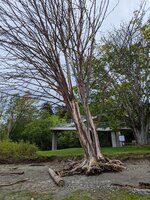
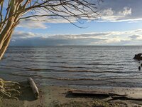
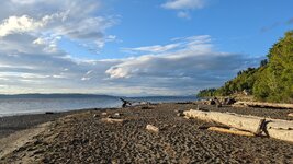
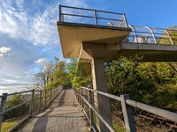
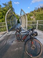
I decided to fight the winds since folks have mentioned it is the benefit of an e-bike beast. Well, there is the occasional buffeting which leads to a profound wobble. But the sun and surf made it a nice expedition. About 15 miles and 700 feet of urban riding with water view payoff. Low tide.

PXL_20220518_205446893-.jpg


PXL_20220518_211112009-.jpg


PXL_20220518_211131882.PANO-.jpg


PXL_20220518_211312133-.jpg
 
I decided to fight the winds since folks have mentioned it is the benefit of an e-bike beast. Well, there is the occasional buffeting which leads to a profound wobble. But the sun and surf made it a nice expedition. About 15 miles and 700 feet of urban riding with water view payoff. Low tide.

View attachment 123732

View attachment 123733

View attachment 123734

View attachment 123735
Nice! ANY ocean view would definitely be the payoff for me.

I dropped my bike off at the LBS in Calgary yesterday for the new motor replacement and was told it should be ready by today. Unfortunately, I likely won’t be able to make the 150km drive down there until the weekend but considering that it’s miserably cold, wet and windy today makes a great excuse to stay indoors.
 
Back