D
Deleted member 18083
Guest
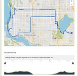
Sixes and sevens …

Deception Bay, Queensland
10:15 am; 50 km
10:15 am; 50 km
Last edited by a moderator:


funny we were talking about that this morning, the irrigation and mist sprays with the heat seem to be doing their job, now there is a winery in Summerland B.C. (Thornhaven) that plays classical musical at night to encourage their grape crop - oh well to each their own I enjoy happy hourIt has been 28 days without rain but it could be a good year for grapes. View attachment 93314
Yes the smoke from 300+ fires ...yikes!Steve - the first thing that caught my attention in this picture is lack of forest fire smoke as we have it rolling across here in Southern Alberta. Mind you, that tinder dry grass on roadway . . .
Um , I see sevens and nines.


yep, got one tooPerfect! I need a battery powered blower to clear the local bike lane I use!
")
You know itIs that an anti-drafting device to prevent analog roadies from piling up behind you ?
Drivers are a lot more polite too!


That or you get to find out how your front suspension works going over one of them!I saw 5 Jackrabbits in the first 10 mins of todays ride so I am pretty certain this Eagle will find his dinner tonight. View attachment 93312
I’d call it 10,000+ feet so altocumulus….Help identify the clouds …
View attachment 93337
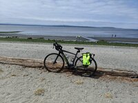
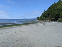
Moreton Bay CyclewayStratocumulus? I'm looking at the line of cotton wool balls running north-south, which happened to be the direction of the wind at sea level.
Bramble Bay, QLD
Also in the picture:
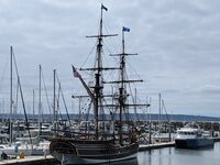
I'll be going up this way again in a few days and will pack a long-barrelled Canon which should bring Notorious within range, providing the crafty captain doesn't weigh anchor and slip out on a midnight tide.
- three-kilometre long viaduct joining Redcliffe Peninsula (our side) with Brighton (Brisbane) to the south;
- intrepid kayaker (far left);
- replica fifteenth-century caravel Notorious (right).
View attachment 93340
Your trips around Baltimore always interest me because my father grew up there in a row house in the 30s. I don’t think you venture into his old neighborhood though because apparently it’s quite dangerous there these days. A few years back my brother and I looked up his address and found out the house was for sale, so we decided to drive down from New York to have a look, and the real estate agent thought we were crazy. But he hired a off-duty policeman to take us there anyway, and we had a good look around the house. Decided it wasn’t a good investment, but it was nice to visit where my father had grown-up as a child.
Sounds like my old neighborhood in The Bronx. And to tie it to bike riding, non-electric back then, we use to ride our bikes out toward Long Island Sound (not really) but to the water body that separated us from LaGuardia Airport. We watched the propeller planes take off and land.Your trips around Baltimore always interest me because my father grew up there in a row house in the 30s. I don’t think you venture into his old neighborhood though because apparently it’s quite dangerous there these days. A few years back my brother and I looked up his address and found out the house was for sale, so we decided to drive down from New York to have a look, and the real estate agent thought we were crazy. But he hired a off-duty policeman to take us there anyway, and we had a good look around the house. Decided it wasn’t a good investment, but it was nice to visit where my father had grown-up as a child.
Someone on here did that type of "bunny hop" last year, and it involved an OTB onto a concrete abutment. And a concussion. Careful out there.That or you get to find out how your front suspension works going over one of them!
Haha... BunnyhopSomeone on here did that type of "bunny hop" last year, and it involved an OTB onto a concrete abutment. And a concussion. Careful out there.
Looks like Portland. Is that the Steel Bridge in the middle distance? I lived in Portland from 2nd grade through 9th. My cousins lived directly above the St John's bridge on the mountain, up a very steep hill indeed. One time a cousin and I were walking back from St.John's when he jumped up on the main cable at the lowest point and started to walk up it. Scared the crap out of me.we went on a nice mountain bike ride on our tandem I had a route all mapped out. well it Wass a 20 mile ride to the top. doing down the map had us go on a fire road. it was Fine for awhile then it got way to tricky for a tandem. so we walked it down the rest of the way a bit crazy but not too bad. so the map took us to another tail going down but it was for hiking. so stupid me figured we would walk the tandem down. well it was ok for a bit but it got worse and worse. but it seemed going back up with be impossible. we had 2 foot drops with roots we had to get the tandem down my wife was having a real fun time of it. someone coming up told us there were steep stains and it was like great. people coming down realized we were having issues and when we got to a really bad part right before those steep stairs. I don't think we could have gotten down them on our own. it was work for us too guys to carry the tandem down and to go around the turns till we got to the road.
we got to cross the St johns bridge and it was a fantastic view.
But this is the thing I used a app thats made to map bike rides and it chose that path even though it is a walking path. When I checked it on google choosing that path from where we were at the top to the bridge google chose that path too.; so it was a lesson for sure. that path would have been pretty hard for my wife without the bike. it was more work then riding. so we got across the bridge found a Chinese restaurant as we were a bit wobbly after getting down that trail. we had a whole battery left so we road the 15 miles back on full assist so we did not have to work too hard. luckily there was a 711 close so we both could get an energy drink after 4 dishes at the Chinese place. ti was pretty good too. 42 miles several miles of walking and over 2000 feet of climbing. You can see the end of the stairs. we had to lift the tandem high to get it around the corners. View attachment 93004View attachment 93005View attachment 93006View attachment 93007View attachment 93008View attachment 93009View attachment 93010View attachment 93011View attachment 93012
 (I can remember riding similar trails with the heavy Trance E+; it was painful to carry that e-bike over an obstacle). There is not only a cycling ban on the gangway but also the structure is indeed unstable (it was apt for resonance with bike wheels!) So I walked, walked, and walked... How lucky I am... The downpour was intensive but short lived. And I could ride home dry.