You are using an out of date browser. It may not display this or other websites correctly.
You should upgrade or use an alternative browser.
You should upgrade or use an alternative browser.
2024 - Our Rides in Words, Photos, Maps and Videos
- Thread starter Saratoga Dave
- Start date


RandallS
Well-Known Member
- Region
- Canada
- City
- Calgary
Nice!Condensed DH Run 1 (Family Guy)
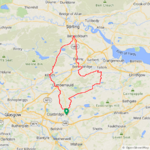
I hit the trails yesterday with the boys on Moose Mountain just outside of Bragg Creek, AB. There was a minimal amount of climbing as we had vehicle shuttles hence most of the hard work was done for us. Nevertheless, the few ascents that remained were brutal made worse by the sweltering heat. Family Guy is a sweet mellow singletrack that winds through spruce and pine forests. No time to stop and take in the views along this fabulous trail that was bench cut by hand as there were plenty of other riders taking advantage of the optimal ground conditions. There is a mix of vegetation including lots of open meadows, where we were treated to abundant wild flowers and great views of the valley below and mountains beyond. Sublime.
View attachment 179284
View attachment 179285
View attachment 179286
View attachment 179287
View attachment 179288
View attachment 179289
View attachment 179290
View attachment 179291
I'd been out that way on Thursday but on a different type of E-vehicle. Golf cart at Wintergreen Golf Course, just north of Bragg on the west side of the Elbow.
Can't bike at present as waiting on warranty work from Giant - battery went stupid and won't power up the bike.
Passes all diagnostics and will both discharge and charge correctly but won't go. Giant Canada being very good about it as bike is 6 months past warranty and they're going to replace at no charge anyways.
I think Ridley's really went to bat for me in that regard with their Giant rep. Once again they've earned my repeat business.
I fellow who used to work for me wants to get me to join him at West Bragg or Moose, but I told him I would only if he was bringing his wife and 10 year old, so I could ride trails of my current capabilities. Hip is toast and collapses at times, so a bugger when riding. Couldn't possibly ride without an ebike these days and can't wait to get mine back.
RabH
Well-Known Member
A perfect day for a nice recovery ride, my 3rd ride in as many days and I can't say that very often this year! Light winds and a nice 19C temp made it a very pleasant ride indeed, I would have preferred to go out much earlier when it was cooler though but I'm not complaining!
 I started my ride with a 44mph descent on a local hill, my best on this one was 48mph a few years ago...might make 50 one day if I'm brave enough!
 After the descent I took the back roads up to Salsburgh, from a big descent to a big climb!
I then joined the main road for only a mile or so before taking the back road to Armadale, a very smooth road after some rough parts at the start!
I joined the cycle path just after this which brings you out at the far side of Armadale, the path looks good but its a bit rough to ride!
I then joined the new cycle path that runs from Armadale down into Whitburn, this one is very smooth! It runs alongside the main road and is way safer especially down the big descent where I had many idiots trying to pass me before they built the path...
I then took the new cycle path from Whitburn to Bathgate and another couple of nice paths to Dechmont, I used to use the road before they built the paths and it wasn't fun at times! I arrived at Dechmont and tackled the big climb up over Burnhouse road, just under a month ago I did this climb on my 15 year old hybrid! It was way easier this time!
Part way up the climb I stopped for this photo looking west!The next part of the climb was awaiting me!
Now at the top!
The Pentland hills in the background here and a plane was on approach to Edinburgh Airport!
Now it was time for a much needed descent!
I decided to turn off before the final descent to get some photos from a better vantage point, with Beecraigs Country Park surrounded by trees in the distance!
The Ochill Hills in the background here!
Now I had this awesome descent to enjoy, I was nudging 40mph down this one!
The road then rises up immediately up to the country park, I stopped for this photo looking back at the hill I came down before continuing up the climb!
I stopped again before the steepest part of the climb for more photos, the bridges over the Forth make a nice view from here!
Almost at the top now, with a nice view of the Ochil Hills!
The Firth of Forth from near the top of the climb!
The final part of the climb, there is a reason I didn't tackle this on my old hybrid...
After this its a short but fast descent, the road then joins the Linlithgow to Torphicen road and I was undecided about which way to go so I stopped for a snack and spotted these 2 posing for a photo!
Looking down the valley at the Grangemouth oil refinery, which is looking like it might close for good next year and is the last refinery in Scotland...sad times!
I decided to give Linlithgow a miss and headed for Torphicen, the road starts with some big climbs and ends with some amazing descents and has some nice views on the way!
I then hurtled down the descent into Torphicen which is quickly followed by another fast descent down to the road that leads to Westfield, I had to enjoy them as I knew what was coming next! I could have taken the easy option but thats not me, I was feeling strong after struggling at the start of my ride so I opted for the climbs from Westfield up over Heights and then down the descent into Blackridge! Its such a great road for a bike anyway so the climbs didn't bother me one bit!
I arrived in Blackridge with 41 miles covered and I knew I had almost 10 miles to go so it worked out perfectly for a nice 50 miler, its virtually a straight road west to home from there! So that was ride no 50 for the year and it was a very enjoyable one in excellent conditions, my mileage so far is 3840 miles so my average is just under 77 miles! It was good to get some rides close together for a change, the weather has been crazy this year so I have had many long breaks between rides!
@RandallS I hope you get your bike sorted soon, my original battery is over 6 years old and still going strong! Have they confirmed the battery is at fault?
Attachments
Prairie Dog
Well-Known Member
- Region
- Canada
- City
- Red Deer
It would have been hot out on the links as well. The heat was so stifling we headed back into town after the ride for refreshments but as hard as we tried, we couldn’t find anywhere to park. Seems like everyone from Calgary had converged on the town in one fell swoop.Nice!
I'd been out that way on Thursday but on a different type of E-vehicle. Golf cart at Wintergreen Golf Course, just north of Bragg on the west side of the Elbow.
Can't bike at present as waiting on warranty work from Giant - battery went stupid and won't power up the bike.
Passes all diagnostics and will both discharge and charge correctly but won't go. Giant Canada being very good about it as bike is 6 months past warranty and they're going to replace at no charge anyways.
I think Ridley's really went to bat for me in that regard with their Giant rep. Once again they've earned my repeat business.
I fellow who used to work for me wants to get me to join him at West Bragg or Moose, but I told him I would only if he was bringing his wife and 10 year old, so I could ride trails of my current capabilities. Hip is toast and collapses at times, so a bugger when riding. Couldn't possibly ride without an ebike these days and can't wait to get mine back.
Bummer to hear about your ride but it sounds like you’re in good hands. My Trance experienced a similar issue and the shop ended up replacing the harness on warranty which ultimately wasn’t the fix that was needed, The culprit instead was traced to a corroded connector to the main power feed. A quick cleanup and a dab of dielectric grease was all that was required. It took a couple of days before I was able to take delivery of the bike. Here’s hoping you won’t have to wait much longer.


Jeremy McCreary
Bought it anyway
- Region
- USA
- City
- Carlsbad, CA
That Armadale-Whitburn bike path looks very enticing. I'm fortunate enough to live in a huge network of reasonably safe bike lanes, but we have very few paved bike paths like that. Some dirt bikeways here and there, but none more than 2 miles long.View attachment 179338
A perfect day for a nice recovery ride, my 3rd ride in as many days and I can't say that very often this year! Light winds and a nice 19C temp made it a very pleasant ride indeed, I would have preferred to go out much earlier when it was cooler though but I'm not complaining!
I then joined the main road for only a mile or so before taking the back road to Armadale, a very smooth road after some rough parts at the start!
View attachment 179339
I joined the cycle path just after this which brings you out at the far side of Armadale, the path looks good but its a bit rough to ride!
View attachment 179340
I then joined the new cycle path that runs from Armadale down into Whitburn, this one is very smooth! It runs alongside the main road and is way safer especially down the big descent where I had many idiots trying to pass me before they built the path...
View attachment 179341
I then took the new cycle path from Whitburn to Bathgate and another couple of nice paths to Dechmont, I used to use the road before they built the paths and it wasn't fun at times! I arrived at Dechmont and tackled the big climb up over Burnhouse road, just under a month ago I did this climb on my 15 year old hybrid! It was way easier this time!
View attachment 179342
The next part of the climb was awaiting me!
View attachment 179343
Now at the top!
View attachment 179344
The Pentland hills in the background here and a plane was on approach to Edinburgh Airport!
View attachment 179345
Now it was time for a much needed descent!
View attachment 179346
I decided to turn off before the final descent to get some photos from a better vantage point, with Beecraigs Country Park surrounded by trees in the distance!
View attachment 179347
The Ochill Hills in the background here!
View attachment 179348
Now I had this awesome descent to enjoy, I was nudging 40mph down this one!
View attachment 179349
The road then rises up immediately up to the country park, I stopped for this photo looking back at the hill I came down before continuing up the climb!
View attachment 179350
I stopped again before the steepest part of the climb for more photos, the bridges over the Forth make a nice view from here!
View attachment 179351
View attachment 179352
View attachment 179353
Almost at the top now, with a nice view of the Ochil Hills!
View attachment 179355
View attachment 179356
The Firth of Forth from near the top of the climb!
View attachment 179357
The final part of the climb, there is a reason I didn't tackle this on my old hybrid...
View attachment 179358
After this its a short but fast descent, the road then joins the Linlithgow to Torphicen road and I was undecided about which way to go so I stopped for a snack and spotted these 2 posing for a photo!
View attachment 179359
Looking down the valley at the Grangemouth oil refinery, which is looking like it might close for good next year and is the last refinery in Scotland...sad times!
View attachment 179360
I decided to give Linlithgow a miss and headed for Torphicen, the road starts with some big climbs and ends with some amazing descents and has some nice views on the way!
View attachment 179361
View attachment 179362
I then hurtled down the descent into Torphicen which is quickly followed by another fast descent down to the road that leads to Westfield, I had to enjoy them as I knew what was coming next! I could have taken the easy option but thats not me, I was feeling strong after struggling at the start of my ride so I opted for the climbs from Westfield up over Heights and then down the descent into Blackridge! Its such a great road for a bike anyway so the climbs didn't bother me one bit!
I arrived in Blackridge with 41 miles covered and I knew I had almost 10 miles to go so it worked out perfectly for a nice 50 miler, its virtually a straight road west to home from there! So that was ride no 50 for the year and it was a very enjoyable one in excellent conditions, my mileage so far is 3840 miles so my average is just under 77 miles! It was good to get some rides close together for a change, the weather has been crazy this year so I have had many long breaks between rides!
@RandallS I hope you get your bike sorted soon, my original battery is over 6 years old and still going strong! Have they confirmed the battery is at fault?
Curious, how many times can you say "Firth of Forth" in rapid succession? Three max for me.
RabH
Well-Known Member
They really are improving our bike paths, it has taken them a long time though but its a step in the right direction for sure! Firth of Forth rolls off the Scottish tongue, I could say it many times over without hesitation!That Armadale-Whitburn bike path looks very enticing. I'm fortunate enough to live in a huge network of reasonably safe bike lanes, but we have very few paved bike paths like that. Some dirt bikeways here and there, but none more than 2 miles long.
Curious, how many times can you say "Firth of Forth" in rapid succession? Three max for me.
Chargeride
Well-Known Member
That sign is hilarious.In Dún Na nGall
County Donegal, the most Irish province of Ireland, north-west, on the Atlantic. The biggest use of the Old Language (Irish Gaelic) here
View attachment 179328
Donegal Airport, Carrickfinn (CFN)
View attachment 179329
The Clady (River) near to Atlantic Ocean
View attachment 179330
Meatpie.
View attachment 179331
Errigal (An Earagail), a mountain near to Gweedore.
View attachment 179332
Directions to Wild Atlantic Way (we are on a travel along!)
View attachment 179333
Kids playing Irish Reel dance music in a pub of Bunbeg late on Monday night!
Stefan Mikes
Gravel e-biker
- Region
- Europe
- City
- Mazovia, PL
Pure holiday with my gf @Brix. Donegal is unbelievably beautiful, especially during good weather we are enjoying now! We both got suntan on a single day!We spent two weeks in Ireland this last spring and really liked it. There on business Stefan?
As you might notice, it is a stylish WAW for Wild Atlantic WayThat sign is hilarious.

The road is a perfectly smooth asphalt, going up and down all the time, and winding. It becomes pretty narrow at times!
I perform rather well in the left-hand traffic although Brix is telling me I veer to the left too often!
We were on Toraigh or Tory Island on Tuesday. The natural beauty is outstanding there! I will post some photos later.
A teaser
Prairie Dog
Well-Known Member
- Region
- Canada
- City
- Red Deer
Despite the hazy conditions due to wild fire smoke, we still managed to fit in a 42km ride this morning. Meanwhile, 400km to the north, Jasper National Park including the townsite has been placed under evacuation notice over the past 36 hrs. 25,000 residents and tourists were forced to flee from the fires which were burning only 8km east of the townsite. The air quality health index at the time had rated our region as 4 out of 10 (moderate) but we couldn’t smell any hint of smoke during the entire ride.

Crossing any highway requires the utmost vigilance particularly in less-than-ideal conditions. Better to have two pairs of eyes scanning to ensure safe access.

A light mist in the air kept us cool and occasionally turned to light rain though it was sporadic. The cooling conditions were quite pleasant in comparison to the blazing heat that we’ve had to endure over the past two weeks. More precip is expected throughout the province this week but it’s likely not going to be enough to slow the fires up north.

Heading back towards homebase, we spot a familiar flashing light in the distance on the other side of the road. Only the missus and another rider we know have the same Lezyne Smartsense lights.

At the spry age of 72, David completed his first Gran Fondo a week ago in the badlands of Drumheller, AB and so congrats were in order.
We stopped and chatted with our roadie friend for a few minutes before departing our separate ways.

Crossing any highway requires the utmost vigilance particularly in less-than-ideal conditions. Better to have two pairs of eyes scanning to ensure safe access.
A light mist in the air kept us cool and occasionally turned to light rain though it was sporadic. The cooling conditions were quite pleasant in comparison to the blazing heat that we’ve had to endure over the past two weeks. More precip is expected throughout the province this week but it’s likely not going to be enough to slow the fires up north.
Heading back towards homebase, we spot a familiar flashing light in the distance on the other side of the road. Only the missus and another rider we know have the same Lezyne Smartsense lights.
At the spry age of 72, David completed his first Gran Fondo a week ago in the badlands of Drumheller, AB and so congrats were in order.
We stopped and chatted with our roadie friend for a few minutes before departing our separate ways.
Chargeride
Well-Known Member
Back in Talybont, Wales.
On the Nduro fat six.
Found the most beautiful Bridle way alongside a heavy running river.

It steeply wound its way alongside the river and several hundred feet above it, every corner was full of entire trees washed down in some past flood.
Eventually popping out at a stone arch bridge built in 1762


Such an atmospheric place, it felt like you had been transported back to the era it was built.

The bridleway continued past the trees into open moorland to a high lake , endless partially collapsed stone walls kept the unreal feeling going.

Looking back revealed a lovely panorama of the beach and the Lyn Peninsula with Abersoch and Porthmadog, the right is the Snowdonia mountains

The path is called the Taith Ardudwy Way and features a Buzzard on the sign ,I saw two them on the way up.

Im guessing this is a Victorian construction designed to look ancient, I think the rocks are there to stop people camping under it.
Edit..it seems this is a neolithic burial chamber

The bike cruised up from sea level, the 4.8 tyres devoured the very rocky path, in fact the bike easily rode up steep slippery steps
Im very impressed, only a 30% down by the time I got to the lake and I was in high the whole way.
It really is a climbing beast.
On the Nduro fat six.
Found the most beautiful Bridle way alongside a heavy running river.
It steeply wound its way alongside the river and several hundred feet above it, every corner was full of entire trees washed down in some past flood.
Eventually popping out at a stone arch bridge built in 1762
Such an atmospheric place, it felt like you had been transported back to the era it was built.
The bridleway continued past the trees into open moorland to a high lake , endless partially collapsed stone walls kept the unreal feeling going.
Looking back revealed a lovely panorama of the beach and the Lyn Peninsula with Abersoch and Porthmadog, the right is the Snowdonia mountains
The path is called the Taith Ardudwy Way and features a Buzzard on the sign ,I saw two them on the way up.
Im guessing this is a Victorian construction designed to look ancient, I think the rocks are there to stop people camping under it.
Edit..it seems this is a neolithic burial chamber
The bike cruised up from sea level, the 4.8 tyres devoured the very rocky path, in fact the bike easily rode up steep slippery steps
Im very impressed, only a 30% down by the time I got to the lake and I was in high the whole way.
It really is a climbing beast.
Last edited:
Stefan Mikes
Gravel e-biker
- Region
- Europe
- City
- Mazovia, PL
Along The Atlantic Coast To Letterkenny
Wednesday 24 July 2024
Were I to write a promotional material, I'd start with the motto: 'Ireland: The Country Where The Things Do Work'. Perfect asphalt roads, mobile payment everywhere (we used no cash so far!), very fast mobile internet, friendly and helpful people! Yes, County Donegal (West Ulster) is a montane province, and you do not drive fast there, especially if you are not a left-hand traffic person! You certainly drive carefully on narrow scenic routes. As Donegal is pretty big by European standards, I do not dare to exceed 50 mile of driving a day. (Many road cyclists can be spotted here!)

The Errigal (mountain) as seen from the north (Atlantic coast).

Dunfanaghy, a town known from its sandy beaches, sand dunes, and golf courses. Surfing is a popular pastime here, too.

Irish Full Breakfast a.k.a. Ulster Fry")

Marble Hill Beach (Portnablagh). People were actually swimming there!

Breaghy Head. Sheephaven Bay. There were many sheep indeed!

A lovely pub in the village of Glen!

Beware of teetotallers!

A mural promoting a local craft brewery.

You can legally have a pint of beer and drive in Ireland. I wouldn't, so I settled on a non-alcoholic ale See @Brix 

The Errigal with its summit in clouds, as seen from the south over Glen Lough (lake).

A living room of our studio apartment in Letterkenny. All conveniences available!

Five minutes of walking to a hypermarket!
Our plans for Thursday involve a boat trip on Swilly Lough (lake) to Buncrana, paying a short visit to Northern Ireland UK (Derry or Londonderry, depending if you are an Irish Republican or British Unionist), and returning to Letterkenny in Ireland.

80+ km route plan. Ireland is totally Metric except pints for beer!

The size of Co. Donegal. Our 4 bases are shown. A week is nothing to see Donegal! (I put "lotnisko" for Donegal Airport CFN. See how far it is from Donegal Town, Base 4!)
Wednesday 24 July 2024
Were I to write a promotional material, I'd start with the motto: 'Ireland: The Country Where The Things Do Work'. Perfect asphalt roads, mobile payment everywhere (we used no cash so far!), very fast mobile internet, friendly and helpful people! Yes, County Donegal (West Ulster) is a montane province, and you do not drive fast there, especially if you are not a left-hand traffic person! You certainly drive carefully on narrow scenic routes. As Donegal is pretty big by European standards, I do not dare to exceed 50 mile of driving a day. (Many road cyclists can be spotted here!)
The Errigal (mountain) as seen from the north (Atlantic coast).
Dunfanaghy, a town known from its sandy beaches, sand dunes, and golf courses. Surfing is a popular pastime here, too.
Irish Full Breakfast a.k.a. Ulster Fry
Marble Hill Beach (Portnablagh). People were actually swimming there!
Breaghy Head. Sheephaven Bay. There were many sheep indeed!
A lovely pub in the village of Glen!
Beware of teetotallers!
A mural promoting a local craft brewery.
You can legally have a pint of beer and drive in Ireland. I wouldn't, so I settled on a non-alcoholic ale
See @Brix The Errigal with its summit in clouds, as seen from the south over Glen Lough (lake).
A living room of our studio apartment in Letterkenny. All conveniences available!
Five minutes of walking to a hypermarket!
Our plans for Thursday involve a boat trip on Swilly Lough (lake) to Buncrana, paying a short visit to Northern Ireland UK (Derry or Londonderry, depending if you are an Irish Republican or British Unionist), and returning to Letterkenny in Ireland.
80+ km route plan. Ireland is totally Metric except pints for beer!
The size of Co. Donegal. Our 4 bases are shown. A week is nothing to see Donegal! (I put "lotnisko" for Donegal Airport CFN. See how far it is from Donegal Town, Base 4!)
Last edited:
Chargeride
Well-Known Member
A place I need to visit, the western edges of Europe get very frayed and wild indeed.
Have you wotched much terrurvision?
Have you wotched much terrurvision?
Stefan Mikes
Gravel e-biker
- Region
- Europe
- City
- Mazovia, PL
I'm lucky (yet) not to be stopped by Garda, the most serious police in the world!Have you wotched much terrurvision?
I'd like to see whether London/Derry is as scary as they say
Chargeride
Well-Known Member
It was crazy during the 'troubles'.
This was what a police station looked like when a modern society enters a 'civil war'.

Anyway, lets not spoil your trip.
Our friends visit a lot and cannot praise it more highly
This was what a police station looked like when a modern society enters a 'civil war'.
Anyway, lets not spoil your trip
.Our friends visit a lot and cannot praise it more highly
RabH
Well-Known Member
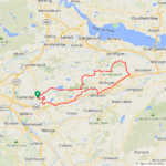
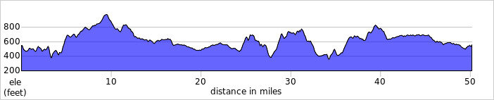
My lucky streak with the weather continued today, my 4th ride in 6 days and I can't say that very often! I did have to alter my ride but it didn't detract from the awesome ride I had planned and actually turned out to be one of my best rides of the year! I was going to head out to Lennoxtown and climb the Campsie Hills at Crow road but as I was on my way down to Cumbernauld the sky to the NW was looking pretty threatening so I changed plans and continued down into Kilsyth where the sky wasn't looking so dark! I decided to tackle the Tak Ma Doon road up over the Campsies, probably the most difficult climb in my near vicinity but also the most rewarding!
Its a very tough climb and starts with a leg burning 18% gradient, the reward comes at the summit at 1100ft with the awesome descent down into the Carron Valley! It was a bit of a blustery day with a SW wind around 25mph, the temp was perfect for riding at around 15C! The first part of the descent is very fast, 42.6mph was my top speed and then its on the brakes to cross the ford which wasn't too bad today, sometimes I have to stop and push the bike across if its too deep!
Then the descent continues!
At the end of the road I had 2 options, turn right and enjoy the descent down into Denny or go straight through and climb for a mile or so and enjoy a rollercoaster road down into Bannockburn! I chose the latter and it was a very wise choice, its a cyclists dream road if you like fast descents!
I have actually climbed it in the opposite direction twice this year and both times it was into a headwind, today I got to descend it with a 25mph tailwind! Its not all descending of course as it is a proper rollercoaster with many ups and downs but the ups in this direction are way easier!
This part next to Loch Coulter is a real blast and very fast!
The Ochill Hills ahead were shrouded in thick cloud!
Loch Coulter, no sign of the sun today!
I continued down towards Bannockburn, nudging 40mph on every descent and arrived at a climb so I stopped for a snack and a couple of photos!
The climb starts gradually before ramping up after this!
Then I reached the final descent down into Bannockburn!
A closer view of the Ochil Hills!
From Bannockburn I turned south for Denny and was using the main road for a good few miles, thankfully it wasn't too bad and the drivers were behaving! From Denny I continued on to Bonnybridge and crossed the canal, stopping for more snacks before tackling the big climbs that were awaiting me!
I started up the first climb and came across a big group of horse riders coming down, so I stopped to let them all pass and was just about to start climbing again when a massive tractor appeared taking up the whole road!
I lifted my bike on to the verge to let him pass, I'm sure he was happy when he saw the all the horses further ahead! I got to the top of the second climb and stopped for this photo looking back down the hill!Then it was another climb but a much easier one!
From here I could see the Campsies to the left and the Ochils to the right!
Then I reached the flat part and had the wind at my back for a few miles all the way into Falkirk! The road is pretty smooth like this almost all the way!
Another view of the Ochils, only just!
From Falkirk I had 2 choices yet again, take the direct road to Slamannan which starts with a big descent followed by a big climb or turn into the village of Lionthorn and head down to Glen Village and take on the big climb there! I chose the latter even though its a harder climb, I was feeling pretty strong today!
I then had a nice descent down into Slamannan and was going to use the back road to Longriggend but it was closed so I had no choice but to use the main road to Greengairs! Its not a very busy road though so no big deal and although I was riding directly into the 25mph headwind I had lots of tree cover to protect me!
A final couple of photos of the Campsies, the second one shows it was almost certainly raining over that way now!
I passed through Greengairs at 48 miles and turned south on to the quiet back roads to home with 5 miles or so to go, it was a big climbing day but my legs coped very well probably due to getting out regularly! What a fantastic day that was, it turned out to be an even better ride than I had planned!
My next ride is looking like Sunday when I'm hoping to cycle to the motorcyle racing at Knockhill, my first bike ride to the circuit this year if the forecast is correct! The weather previously has been truly awful so fingers crossed Sunday will be my day...Attachments
Stefan Mikes
Gravel e-biker
- Region
- Europe
- City
- Mazovia, PL
Something for you, @Chargeride
Greetings from The United Kingdom of Great Britain and Norn Iron The only difference to Ireland are speed restrictions in mph and prices in £! Chargeride
Well-Known Member
Norn Iron
dodgeman
Well-Known Member
- Region
- USA
- City
- Macomb, Illinois
I road 17 miles today, I couldn’t get my wife to go with, it was very humid. A picture of an off road side by side, technically not road legal but you see them on the roads all the time. Also a picture of a patch of sweet corn. You can see how much shorter it is compared to the field corn in the background.


Prairie Dog
Well-Known Member
- Region
- Canada
- City
- Red Deer
Good on you for riding in such conditions. I think that I prefer venturing out in sub zero temps as humidity is an absolute game changer for me and would find it difficult to breathe.I road 17 miles today, I couldn’t get my wife to go with, it was very humid.

Similar threads
- Replies
- 1K
- Views
- 132K
- Replies
- 3K
- Views
- 474K
- Replies
- 2K
- Views
- 548K