2024 - Our Rides in Words, Photos, Maps and Videos

Exactly as I thought, surely knowing where you are to a ten foot circle will give your exact height from a tiny database.
I just pasted that from a gps forum.
 
GPS isn’t really that much worse in the vertical than the horizontal. Think about how the error might affect things. If you ride ten miles and the distance is off a 1000 feet, that’s not that much. If your climbing elevation is off 1000 feet, that’s a lot. Your elevation climbing amount is probably not off that much either. If you are looking at percent slopes or grades, how is the software handling elevations? Is it grabbing just one at the top and bottom, using several along the way? I used gps all the time for land surveying and knew how the software handled things, I don’t know how the various bike apps handle it. Surveyors are also usually using equipment that has roughly cm level accuracy.
 
1720582757238.png

Barometric altimeter (Wahoo)


1720582791831.png

Map (Strava)
 
Guys, I was on a 94 km ride on the probably hottest day this year with temperature approaching 36 C (96 F), almost all the time in the sunshine. The last 60 km were upwind, and I rode my Vado SL with the 40/100% asssistance (SL Turbo for the few last kilometres). I'm surprised I've survived the ride, as the dehydration was close! My stomach hurt from all the beverages I was forcing into my body! Again, my Fearless deserved its name :)

It is an interesting experience when you discover the coldest part of your e-bike is the place where you hold the handlebars :)

I'll make a photo report later. It is a very warm night here...

1720649937031.png

"Smelly Cat, Smelly Cat, what are they feeding you?" :) (A picture from the Häulander Land).
 
It rained all day here, in fact I had to put the lights on in the house, my mother had the heating on!
@Brix says 'It is the ideal weather in London now, and let it stay that way!'
This year was so warm in Poland we now have the apple season, and the harvest is coming! (It should be in August!)

Besides, congratulations to England for qualifying to the Euros final!
 
1720713737805.png


I finally managed to get 2 rides done in the same week for the first time in quite a while! Conditions were overcast with rain threathening but I was determined to get out, especially given it was a very calm day for a change! I decided it was going to be a day for me and the bike only, just amazing roads with no photos or distractions! I headed for the back roads down to Allanton, opting for the amazing descent down into Hartwood and on into Allanton! I have only been climbing this road recently, its way more fun going down it at close to 40 mph! :D

From Allanton I headed east on the main A71 out to Addiewell where I turned south towards Auchengray and up the big climb to Tarbrax at 1100ft! I then enjoyed the descent on one of the best cycling roads in the country down into Carnwath, it really is amazing and the road is in great condition! I headed west from Carnwath on the main A70 and turned south for Lanark which is another very enjoyable descent over the railway crossing at Cleghorn, for once I got across without stopping for a train!👍

I was amazed to see Lanark quiet for once, possibly due to the schools being closed for the summer break! I then shot down the big descent to Kirklfieldbank and into the Clyde Valley, another road I have been climbing mostly recently and not a car in sight all the way down...not that they would be able to overtake as the bike can go way quicker on this twisty descent!😂 I continued along the valley to Crossford where I turned north to take on the Coziglen climb, a really tough one but a powerful e bike just zips up it when you use level 3 assist!;)

At the top of the climb I arrived in Carluke and turned before the town centre to take the back road past the golf club and garden centre! Then I had another big climb up to Law Village, all the time I could feel rain in the air but it wasn't even making the roads damp! I continued up the climb and turned towards Bogside where I took the back road to Morningside which has 2 nice descents to enjoy, before tackling the big climb up to Allanton!

Then I headed up the back road to Hareshaw, yet another big climb and joined the main road to Newhouse with 65 miles covered! From there its a straight road NW to home, with a nice descent down into Chapelhall where I came across some road works and a big line of cars and trucks! I took to the paths and left them all in my wake...then up the final climbs to home! What a brilliant day on the bike, I loved every minute!:D I actually passed 33000 miles today, 33037 to be exact! After all the 100 milers this felt like such a short ride...😂
 

Attachments

  • trip-200708261-map-full265.png
    trip-200708261-map-full265.png
    498.2 KB · Views: 57
  • elevation_profile265.jpg
    elevation_profile265.jpg
    22.9 KB · Views: 63
We met my sister in law and brother in law at a nearby state park called Weinberg King. We rode all the park roads twice and it was still only about 10 miles but it was a nice day. I plane was crop dusting a nearby field and flying very low over us.
IMG_3526.jpeg
IMG_3527.jpeg
 
'Antonio, fa caldo!'
Hauländer Land Ride, Wednesday July 10th, 2024

There was a Nestea Ice Tea commercial, in which an Italian wife was wriggling in the bed and moaning 'Antonio, it's hot!' So Antonio had an idea and brought the wife a glass of cold Nestea :) I always moan 'Antonio, fa caldo!' when the heat becomes unbearable! (Only last night we had a thunderstorm and rain!) I set off for a Vado SL ride on Wednesday, so far the hottest day of this year :)

1720745996769.png

Fortunately, Poland is not Germany, so unlike the Deutsche Bahn, the Mazovian Railways do operate :) It is so convenient for me to save unnecessary bike ride kilometres just riding a train! (It is sunflowers outside!)

1720746141250.png

I'm planning a group ride for August 4th, so I wanted to do a recon of the route just to make sure. The ride would be almost purely on asphalt with a short segment of a poor gravel road.

1720746528520.png

The entry of the Wilków Road (winding through the Kampinos National Park forest). This place feels magical to me!

1720746601293.png

I just love Wilków Road! It crosses several parallel high sand dunes that form the KPN, is winding, and of the top quality! You also are hidden from the direct sunshine there!

1720746938789.png

In the Hauländer Land. The stork family brings the prosperity to the village!


Hauländers
You who are with me for a long time know everything about the Hauländers but let me explain the matter to you new friends.

Original Hauländers were Mennonite refugees from the Netherlands and Frisia who settled along major Polish rivers since 16th century. They were river/flood control experts, and were given a great freedom and autonomy in Poland. Hauländers were free people (nevers serfs), acted as a whole community, and used money for paying the land rent (never labour, unlike serfs). The Hauländer community was soon joined by a huge number of Protestant German settlers. Some Polish communities based on the Hauländer model were created, too. Unfortunately, the great Hauländer culture was lost as the outcome of WWII, as almost all Hauländers were expelled to Germany post 1945 :( (However, not all of them; some members of my greater family are direct descendants of Hauländers). Note: Wikipedia names that nation Olenders but I keep the original German spelling here.

1720748227482.png

The store "At Marta's" in Secymin Polski, or a favourite destination of road cycling pelotons :) It is interesting to learn Marta's family are horse breeders! It became very hot at that point with temperature approaching 36 C or 96 F. I understood the importance of being properly hydrated at that point, having some 60 km ahead of me! OSHEE (an isotonic drink), aloe drink, and a bottle of beer for later (I am drinking it as I am writing, haha!) "Kampinoskie" is a local brand, which is brewed in the craft Błonie Brewery. The guys to brew Kampinoskie have understood regular people would not drink craft beer so they brew Lager of the top quality, and that sells extremely well!

1720748678338.png

An Hauländer Protestant Church in Nowy Secymin. (I can bet the village name was Secymin Niemiecki, or
German before 1945!)

1720749132601.png

Hard to believe but this is a numbered state road #898 "incidentally" broken by the Vistula! Of course there should be a ferry there, but there isn't!

1720749289697.png

And they say there are no steep hills in Mazovia, heheheh :D Yes, you need to climb the Vistula embankment!

1720749366104.png

The harvest time in the Hauländer Land. It smells the summer! (The vegetation sprung up to the life very early this year. Usually August is the harvest month!)

1720749495992.png

The two eating places en route did not operate outside weekends.

1720749552500.png

I guess it is the opium poppy in the full bloom!

1720749609268.png

A landmark. The Vistula embankments continue for hundreds of kilometres; the Hauländer nation used to live along the big part of the river!


The return was the hard part. I was riding in the sun with hot headwind that acted as an air fryer! Had to keep the SL 40/100% assistance to arrive home still on a single battery set. I was forcing myself to intake more and more fluids to the level my stomach hurt! I was fully aware I had to drink: it was easy to dehydrate at that temperature!

1720749945868.png

Taking a long rest in the shade, Roztoka KPN recreation site.

1720750041159.png

Overheated in the air-conditioned McDonald's in Błonie. The last 10 km was such an ordeal I had to refrain to the SL Turbo mode! Back with 9/16% batteries.


A Soultmate

As I parked my Fearless by McD, I could spot a beautiful pale blue bike there, no logo on the frame. I had a closer look at the equipment... As I entered the restaurant, I approached a helmeted man having his ice cream. I friendly begun:
-- 'Is it your bike, Sir? I can see you have a good taste for the equipment! Redshift suspension, a Specialized Tailwind pannier...'
He looked through the window:
-- 'Unbelievable' -- he remarked -- 'we both even use the same Ortlieb rear racks!'
-- 'It is so good to meet a soulmate!' -- I smiled -- 'What is the brand of your bike?'
-- 'That's an Orbea!'

Guys, the man had even ordered a custom frame painting from Orbea to have his bike in the beautiful pale blue, and no logos! :)

1720750634877.png

I admit I was shaking from exhaustion upon my return home!
 
Last edited:
Family vacation up in central PA last weekend, I managed to sneak away one morning to visit Raystown for an early morning solo MTB ride in sauna conditions. Banged out 20 miles in about 2 hours, saw only 3 riders, abandoned my sunglasses about 2 minutes in, went off the trail due to overconfidence twice, found one trail that the locals definitely don't ride and scratched up my arms and legs in a dozen places. :p

ZMS8gLG.jpeg


5NEY4Mh.jpeg


lnP1C4R.jpeg


f15ebtF.jpeg
 
A Brotherly Ride: Bathory Farm
(Along rivers Bzura and Vistula, Kampinos National Park)

'Any plans for Saturday?' -- my laconic brother Jacek messaged me the evening before -- 'The wind direction?' -- I followed the suit -- 'Westerly' -- 'Grab the route then, and we are going to meet each other on the train!' :)

1720953438735.png

Just the general ride map so you are oriented.

1720953712095.png

Jacek and I know each other "as good as two bald horses" or "as good as a bad shilling" :D Jacek now rides a Marin DSX 3 flat handlebar gravel bike, and keeps his Giant Trance E+ only for the cold season or for high mountain trips (although he could successfully ride his Marin in high mountains this year!) After 16 km of a fast ride on good asphalt, we crossed the River Bzura trestle bridge in Witkowice.

1720954060549.png

1720954087659.png

We missed a gorgeous view of Bzura from a meadow but later got onto a long river embankment to catch a quite nice panorama! Necessary to mention the off-road segments are usually a pain to ride because of the abundant sand but fortunately two violent rainfall on preceding nights made the sand quite packed and smooth.


1720955608830.png

Jacek exploring a dilapidated narrow-gauge railroad. (Hard to believe my brother is 60!)

1720955748243.png

From that point on, we only rode narrow, perfect, quaint asphalt roads for many kilometres. During very warm weather, I do not pull the braces (American: suspenders) of my Castelli bibs on. The downside is the chamois becomes crumpled, and I need to get up from the saddle once in a while to relieve my butt! :) (When the bibs are properly braced, I pay no attention to my butt at all!)

1720954484134.png

In an old Olender (Evangelical) graveyard. An interesting story was found by Jacek later, after he inspected genealogical records. Mr. Karol Klatt, a sentry from Żyrardów married Miss Olga Link (living with her mother) in 1937. Olga must have sadly died during childbirth (1938). One of the marriage witnesses, Edward Czens (a factory worker) married the older sister of Olga, Alida already in 1922! (Genealogy is something impossible...) How Olga's remains ended up in the Olender cemetery on the Vistula will remain a mystery.


Note the "Schwięty spokój". In proper Polish, it is "Święty spokój" (holy peace). It looks the Olenders, or Vistula Germans could speak Polish but not necessarily write it!

1720955360979.png

As we eventually got onto the 575, we could ride at high speed with tailwind! I got myself at 45.6 km/h (28.3 mph) riding my Vado 6.0 only at 40/40% assistance!

1720955958392.png

"At Marta's". My brother and no beer? Unbelievable! :D

1720956017307.png

The Olender land is full of horse-breeders!


1720956085460.png

At the Bathory Farm. It is a large family owned recreational area. Established by a Hungarian family and maintained with the help of their Poland's born children.

In 1920, Entente enforced the Treaty of Trianon, depriving the huge Kingdom of Hungary of most of its land and nationals. That makes a big part of Hungarians ultra-patriotic, and you can see that in the Bathory Tanya/Folwark Batorówka/Bathory Farm. (The farm was named after Stephen Bathory, a Hungarian national and one of the most successful Kings of Poland-Lithuanian Commonwealth). There is a saying: "Pole and Hungarian are two nephews/comrades: As good to the sabre as good to a wine glass!" Indeed, the Polish-Hungarian history was quite friendly and with no big tensions (the two countries shared the border for hundreds of years).

1720956801351.png

I felt like in Hungary! A bowl of Gulyasleves (literally: Shepherd's Soup) incorrecly known as Gulash Soup. Accompanied by a slice of proper Hungarian white bread. I asked for hot pepper, and I got a jar of the iconic Erős Pista (Strong Little Stefan) :D which is a staple condiment in any Hungarian home. Of course I put a full tablespoon of Hot Paprika into the bowl!

1720957447468.png

1720957479776.png

I hated the thought of riding through the Kampinos National Park on my heavy Vado. However, the rain made the surfaces a tad easier to ride...


1720957561565.png

The interesting ride part with POI. I rode the main part of the trip in 40/40% assistance with the battery swap at 80.0 km (14% battery left).
 
Last edited:
1721064375329.png


A perfect day for a long ride with light winds and a lovely 16C when I set off at 8.30am! There was a risk of heavy showers in the afternoon but with a mild temp I wasn't too bothered about getting wet, it can be refreshing anyway! It was actually a holiday weekend in my area so I was hopeful the traffic might be light for a Monday, thankfully it was so I was able to stick to the main roads for a while to cut down on the amount of climbing that would ensue if I had to use the back roads! The plan was to head down to Peebles in the borders as its such a beautiful area and the roads leading to it are excellent!

I headed SE on the main roads to Carluke where I turned east for Carnwath, it starts with a lot of climbing and ends with some amazing descents! The first climb summits at Kilncadzow and I stopped for my first photo just after passing through the village, the sky was looking very nice at this point!

1721071441645.jpeg

I then enjoyed the descent down into Carnwath where I took the quieter road down towards Biggar, it really is a fun road to ride and with Tinto Hill lit up by the sun in the background it was looking so nice today!

1721071647514.jpeg

Then I had this awesome descent to enjoy!

1721071748682.jpeg

A closer view of Tinto Hill from the bottom of the descent!

1721071804509.jpeg

To the east I had the Pentland Hills way in the distance!

1721071853001.jpeg

The excellent views just kept coming on this fantastic road!

1721071911343.jpeg

Just before I arrived in Biggar I took these photos!

1721071998336.jpeg

The final descent down into the town is so much fun and with the Culter Hills in the background it just looked incredible!

1721072294057.jpeg

From Biggar I headed NE through Skirling and on to Kirkdean where I had a really nice and much closer view of the Pentland Hills!

1721072419407.jpeg

The local wildlife were taking an interest!;)

1721072479676.jpeg

1721072493226.jpeg

1721072506391.jpeg

Just after Kirkdean and before Blyth Bridge I turned on to the main A72 which leads all the way to Peebles, its one of the best cycling roads in the country and with the great conditions and little traffic it was just sublime! The nice views kept coming also!

1721072707226.jpeg

I arrived in Peebles and took this photo of the River Tweed from the bridge in the centre of town! This is looking east!

1721072771755.jpeg

At this point the sky was starting to change out to the west with dark threatening clouds rolling in, this was taken from the excellent cycle path after passing through Peebles!

1721072912457.jpeg

The path twists and turns for a mile or 2 before running alongside the main road!

1721072960393.jpeg

The path ends just after Eddleston and leads on to a quiet back road that runs to the NW where it joins the main A701, its a 3 mile climb but nothing very steep and you get amazing views of the Culter Hills!

1721073229109.jpeg

Some of the road is really rough but some is like this!

1721073263272.jpeg

This is from the top of the climb looking back down!

1721073340939.jpeg

Another 2 photos before joining the main A701 to head back towards Biggar!

1721073761986.jpeg

1721073784952.jpeg

After this part the road drops down steeply and joins the main road at Whim which was my turning point, I was now heading SW back towards Blyth Bridge and that's when I could feel rain in the air for the first time! Nothing heavy at this point though but I could see the dark clouds in the distance where the rain was looking very threatening! I continued down the A701 and the rain stopped but I knew I wouldn't be able to avoid it and would almost certainly get a soaking at some point!

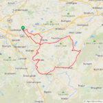
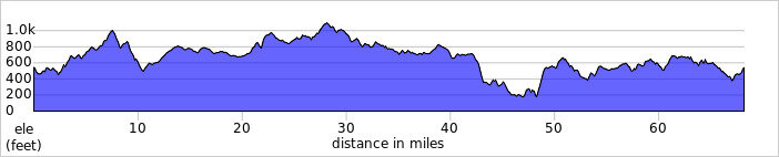
At Kirkdean I had covered just under 64 miles and my first battery had dropped to 20% so I switched batteries, I had actually climbed almost 3500ft at this point so that was good going! Eventually I arrived back in Biggar and turned north to take the back road to Elsrickle, then the rain started to get heavy and the roads ahead were now soaking wet! Imagine my surprise when I suddenly reached dry roads again after less than a mile and I got to enjoy the big descent on a totally dry road before heading up the climb to Elsrickle! At the end of the road I headed NW towards Newbigging and the dark clouds were threatening once again, I could actually see a squall passing over the fields and attempted to outrun it but I had a big climb to take on up to Kaimend and was lucky to only catch the edge of the rain! I decided to take the back road to join the A70 here and avoid Carnwath which looked like it was getting a good soaking!

As I climbed the back road the rain subsided but the roads were very wet and remained so for many miles, at the end of the road I took the back road to Auchengray where the skies were starting to clear and just after passing through the village I came across dry roads again, I had made the right decision going this way for sure! I then passed through Woolfords and headed up the climb to Cobbinshaw and was looking forward to the big descent that was about to greet me, almost 45mph down this one!:D

I then took the road to Addiewell and Loganlea which leads to Breich and headed north through Longridge and Whitburn and the roads remained dry, all the time I could see the dark clouds out to the west and knew I would have to face the rain again at some point! I passed through Longridge and Whitburn with rain starting to fall, then headed west for Harthill and up the big climb and was glad of the rain which was cooling me down up the climb! I then enjoyed the descent down to Kirk of Shotts where the 100 miles arrived on my gps and I turned north to head past the Blackhill transmitters where the skies were looking brighter and I came across dry roads again!

1721075965297.jpeg

Roughrigg Reservoir!

1721076008171.jpeg

I enjoyed this awesome descent with the Campsie Hills in the background!

1721076044329.jpeg

Looking back up the hill I just descended at high speed!

1721076114899.jpeg

Another view of the reservoir!

1721076151677.jpeg

1721076165303.jpeg

Then I shot down the final descent into Plains and turned west for home with only 2 miles remaining! I sure got lucky today with my rain avoidance today, I'm good at reading clouds though!;) What a brilliant day on the bike, the roads were just incredible for the most part!👍I arrived home very tired of course but absolutely buzzing!:D I'm loving the challenge of taking just the 2 batteries for these 100 milers now, its a lot less weight to contend with and my second battery still had 30% left when I got home so range anxiety wasn't on my mind!
 

Attachments

  • elevation_profile266.jpg
    elevation_profile266.jpg
    25 KB · Views: 51
  • trip-202356657-map-full266.png
    trip-202356657-map-full266.png
    374 KB · Views: 61
Back