Mr. Coffee
Well-Known Member
- Region
- USA
- City
- A Demented Corner of the North Cascades
Bucket list ride today:


Bucket list ride today:
View attachment 52944
View attachment 52945
View attachment 52946
View attachment 52948
Beautiful area for a ride... what is your general location?


This was countryside that I used to know well from my years foxhunting. Let me amend that: It was countryside I used to know well a quarter of a century ago when I was foxhunting.


Great writeup Readytoride! On my list is a loop I stole from a friend that parallels 15 from Leesburg to Bull Run mountain, runs it to the southern end, then comes back to Leesburg on a path sorta similar to what you were doing.
We actually have two foxhounds. Foxy (the smaller one) is even from one of the hunts around Middleburg. Great dogs. Slightly scent driven.

It's quite a lovely bike to ride, and to look at. I'm very very happy with it. It's smooth, quiet, effortless, beautifully designed, and a pleasant, agreeable, well conformed partner to have on any ride of any length. The only change I have made on the bike is to add a stem riser. It absolutely made the comfort level for my hands go up 100%.What are your impressions from riding your Vado so far, @Readytoride? What assist modes do you prefer to use? What range can you expect with your hills? Have you already tried Smart Assist?
I'm very much interested.
Thank you for the answer!I have a new 600w battery to try out - perhaps next week - to see what happens to my levels of range.
Basically a modified version of this route:Is that Tail Race Road? I know of a few gravel roads that could comprise a loop down to and alongside the Bull Run - like Rt. 600. Very beautiful landscape that is sadly being threatened by development encroaching up from counties further south. Guess we better get out and enjoy them now while we can.

 ridewithgps.com
They definitely like to dogpile on us whenever we sit on the couch or try to sleep. And yeah, their nose substitutes for all other senses (and their brain) when we walk or hike. Definitely can't be walked off leash, unless you want to have to pick them up from some animal shelter 100 miles away a few days later. They catch the scent of something and they are gone.What a lovely couple of hounds!! Foxhounds are the sweetest animals - total couch potatoes if you let them, and really amicable walking companions ... if you don't mind their nose being on the ground the majority of the time.
The big old Rhodies in our neighborhood are unbelievable right now.
You need to start writing ebike p#rn, Im sure theres a niche.Hills, Hollows, Headwinds, and Halfway
It had been several busy days around the farm before I had the opportunity to leap on my bike and head south again, into a brisk headwind, still intent upon chasing the paved roads in the county below us.
I had left several options open for myself, all of which required the presence of cell phone coverage which, in the parts of Fauquier County that I would be traversing, would be ephemeral at best, and nonexistent at worse. Why I was going to rely upon my phone's tenuous connections with all too few cell towers for GPS directions, and not simpy print out an area map (which would have been the smart move), was beyond me.
Maybe it was my sense of adventure calling. Or maybe it was because I hadn't gotten around to hooking up my new computer printer. Either way, I embarked on this ride with a great deal of confidence that my phone would suffice for directions, and my less than faultless memory would back it up to take me on a big loop through the countryside.
Fingers crossed. (Not just two of them . ALL of them!)
View attachment 52962
The first 8 miles south were familiar roads, passing the familiar hunt jump that had yet to be painted, but now sported a prominent blaze orange board for whatever reason. I'm done trying to figure this landmark out, but do find its ever changing permutations entertaining.
View attachment 52968
At the end of 8 miles I entered the town of Middleburg, not surprised to find it still a bit of a ghost town, courtesy of the lingering virus threat and our county's reluctance to open for business as usual just yet. A few masked tourists wandered up and down the sidewalks, peering into closed shops, and aimlessly looking around at the historic building facades for something to do besides nothing at all.
Middleburg was not my destination, however. It was merely a jumping off point to the roads just south of town, and I left the silent burg behind me as I pointed my bike down a very pleasant, winding paved road called The Plains Road. If one cared to pedal to the very end of this lovely countryside road, one would find themselves in a lovely little town called The Plains. A town know for it's expansive polo fields, foxhunting, steeplechasing, equestrian event centers, and very large estate land holdings. And several really nice restaurants that are probably anxious to reopen for seated guests rather than the current takeout crew.
View attachment 52969
My goal, however, was not The Plains. My goal was to cut over to the west and travel a loop through the countryside towards Upperville. This was countryside that I used to know well from my years foxhunting. Let me amend that: It was countryside I used to know well a quarter of a century ago when I was foxhunting.
But now I was struggling to remember as things seemed to have shifted somewhat. Funny how one's mind will play tricks on you, especially when the old familiar landmarks somehow were not where you expected them anymore.
I wasn't that far down the road when I decided to consult my preloaded route on my phone and expand out the map, not realizing I had entered the Twilight Zone of zero cell coverage. My phone did it's best to try grabbing a signal. Any signal at all. It really did try. And I spent at least 10 minutes standing on the side of the road, giving my phone as much encouragement as I could before we both gave up. With no cell coverage to be had, I was essentially on my own with my aged memories as my guide.
I decided to keep going south, in hopes of finding a cell tower, or a connecting road that looked familiar and was paved. I did find one, but within a few hundred yards it reverted to gravel, and had a fresh layer of stones that my Vado did not like. I stood for a few minutes and debated, but if my memory served me correctly, the road would be miles long. A truck lumbered up the road as I stood, and I watched the billowing dust behind the truck be blown by the wind into a choking cloud so thick the road was practically obscured. The Vado was already showing its displeasure at the gravel, and I had to agree. I turned back and rejoined the paved road.
I didn't mind the paved road as it was pleasant , the traffic friendly and very gracious, and the smiles and waves of the motorist were genuine and freely given. And the road was as smooth as silk. An absolute joy to ride. And no dust.
At about halfway to The Plains I hit Halfway. Honest. Not kidding. That was the official name of this nondescript point. It even had a state designated sign. It may have been a small (really, really small) settlement at one time with a single gas station and a few roadside houses, but those glory days were long gone and buried deep. I was in and out of Halfway before I even halfway blinked.
And there was still no cell coverage. And no way of accessing the bigger picture of my phone maps .
I continued south, recognized two gravel roads leading off from the main road, but no adjacent paved roads to take me west. At about 13 miles I was starting to wonder if I was going to have to turn around and head back, but by then the road met up with a local stream and changed course to follow a meandering path that suddenly was very recognizable to me. I knew at some point close by was a paved road heading back to Middleburg ...and there it was!
Hallelujah!
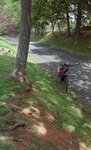
I turned my bike off the main road onto the new road, and suddenly found myself on one of the prettiest Virginia byways I've ever seen. I was completely enchanted with the countyside, drawn in by the gorgeous scenery, the stunning distant vistas, the effervescent hills and deeply shaded hollows that surrounded this wonderful treasure of a road.
View attachment 52970
Barely a car passed by as I looked about me, so delighted with each new view that my bike spent half its time waiting patiently for me to finish taking photo after photo. Often times I had to scramble up steep embankments to get the best shots. My bike was happy to wait below until I could scramble back down to the road so that we could continue in our journey.
View attachment 52978
View attachment 52971
View attachment 52972
No matter which way I looked there was always a sweeter photo just over the next hill. The Bull Run Mountains moved in close enough on my right to warrent several photos before easing further east as my road wiggled a bit more west while still continuing north.
View attachment 52973
To my left the imposing beauty of the Blue Ridge could be seen in the distance, the perfect backdrop for the gently rolling Fauquier farm lands artfully framed by lines of impeccably constructed and maintained stone walls.
View attachment 52974
I seriously wasn't sure what was going through this person's head in positioning 4 lions at the head of his driveway. This shot only captured three, but trust me when I tell you there were four lions, all sitting on individual stone pillars. Somewhere, I'll bet, there are two libraries missing their lion statuary.
View attachment 52975
All things eventually do come back to where we started, and I was delighted when this exquisite road faithfully delivered a very happy me back to Middleburg. While my options at that point gave me no choice other than to retrace my steps back towards home, there is no doubt I will definitely plan to enjoy another turn on this absolute delight of a road in the near future.
View attachment 52976
Oh, I'm SURE that would be just a peachy addendum to those lofty literary achievements on my resume.You need to start writing ebike p#rn, Im sure theres a niche.

Sorry to hear about your off, I'm glad it wasn't serious! Are you a giant?I've been off the bike a few weeks on account of a tumble. Fear not, nary a scratch on my new bike - my parenting instincts kicked in and my chin and knee took the weight of the fall. Phew!
So healed knee and jaw that can once again clench, strong headwind, icy 12 degrees out (ahem, celcius - cold for our temperate climes), perfect night for a ride!
And it was. Night riding is that bit more exhilerating. There's a quality of the 'other' about it, it's not an activity I'm accustomed to so it's that bit more exciting. Plus you have the tracks and roads to yourself.
View attachment 53077
12C at night is warmer than our summers 50mph winds here and they will continue tomorrow and part of Sunday so the bike will be staying indoors with me...How about it pmcdonald? Let's have the goods on that tumble threesome with you, the bike, and the hard ground. (Just remember I didn't start this. [Pointing accusing finger at chargeride])