Our Rides in Words, Photos & Videos

In the same vein my old buddy (now deceased…but of natural cause), a bit of a vagabond, pulled off a road in the dark in Nebraska. though it was below freezing he got out of the warmth of his truck and into the ‘Zero degree” sleeping bag he used to brag about. He was in it to the top of his head until about 3am when Amtrac sped by ten feet from His head
 
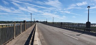
Today's kind of figure eight route through the UW campus, onto the SR-520 Floating Bridge (I think the longest floating bridge in the world) which was pleasurably traffic free since they were doing work on one end, across Lake Washington around Medina and Hunts Point and home. About 22 miles and about 600 feet of gain.

Medina-520.jpg


520 Bridge with no traffic - peaceful quiet. Otherwise I consider it an assault on the senses!
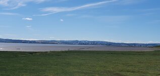
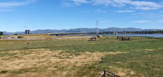
PXL_20220709_182850547-.jpg


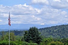
Overlook from the eastside of the lake
PXL_20220709_183805282.jpg


On the way back, Husky Stadium on the lake shore.

PXL_20220709_193154547-.jpg


PXL_20220709_193210153-.jpg


I guess LED's don't photo graph well!!!!!
PXL_20220709_193625538.jpg


PXL_20220709_194258916-.jpg


Part of the UW Medical Center.
PXL_20220709_194324995-.jpg


These feet were made for WALKING!!!
PXL_20220709_201059235.jpg
 
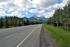
Soaking in the sights at Highwood.

As promised, here is my trip report from yesterday’s ride as my wife and I cycled up the highest paved road in the country. This would be round two for me as I accompanied my BIL last September along the same route as my better half was unable to ride due to a minor back injury. Our hopes of riding up the Pass before it opened up to vehicular traffic in May were dashed once we were told by the park authorities that cyclists would not be allowed through the gates until a bear advisory was lifted.

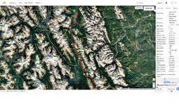
Web capture_9-7-2022_105343_ridewithgps.com.jpeg Screenshot 2022-07-09 at 10-48-07 Garmin Connect.jpg
Things would be a bit different from last season as we have been training daily riding both indoors and along local rural roads just to prepare for tougher rides like Highwood. We decided to attempt to cycle without PAS for as far as we could possibly ride. Everything was going well until we hit the final 7km at the Little Highwood Pass trailhead and a brick wall of a climb to the top. No way Jose…ain’t gonna happen as we ultimately kicked our rides into sport the remainder of the way.

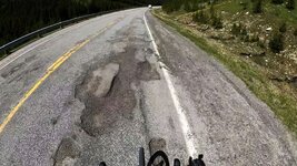
The entire ride went smoothly despite a tire puncture on a fast descent on the return leg. Not something you want to happen at almost 70 kph! The severe wobble disabled my ride temporarily as I could see my wife disappear down the descent. With no time to spare (pardon the pun) I quickly pulled over and pumped up the tire to its max and carried on slowly down the remainder of the hill. To my surprise the air held but I continued to monitor the pressure and stopped a few more times to replenish it and was able to finish the ride in this manner. A 14km stretch of road leading up to and down the Pass were in severe condition with gravel and potholes evident both on the shoulder and the main road itself. I’m afraid that Alberta winters are not very kind to alpine tarmac.

Most cyclists we saw started out on the other side at the south gate and rode up to the Pass in the opposite direction. This seems like the most popular route for most but coming from Cochrane we opted for the northern out-and-back instead starting from the Ribbon Creek Day use area near the Kananaskis Village and would eventually terminate at the Ptarmigan Cirque parking lot only a mere 500 meters from the highest point.

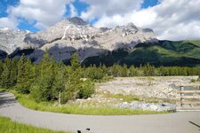
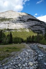
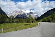
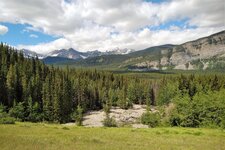
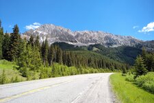
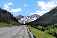
Without further adieu, here are the remaining photos and video of our Highwood Pass trip. There was no shortage of spectacular scenery along the route. Lesser-known K-Country in Peter Lougheed Prov Park is certainly up there in terms of sheer beauty with more popular destinations such as Banff and Jasper National Parks as well as Kootenay/Yoho.

IMG_20220708_1413547.jpg

IMG_20220708_1343204.jpgIMG_20220708_1405490.jpgIMG_20220708_1407456.jpgIMG_20220708_1332198.jpg

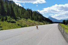
Mountain sheep were abundant licking any remnants of salt along the road.

IMG_20220708_1449126.jpg

IMG_20220708_1451109.jpg

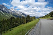
Magnificent view from the saddle, wouldn't you agree?

IMG_20220708_1449189.jpg


....and this one of the the mtn range near the Fortress Junction.

IMG_20220708_1449296.jpg

IMG_20220708_1449404.jpg

A stopover with a convenient bench and a view that isn't too shabby either. :cool:

IMG_20220708_1453355.jpg
IMG_20220708_1513468.jpg

Sai prepares herself for another climb up towards the Pass.

IMG_20220708_1607248.jpg

IMG_20220708_1611307.jpg

No big surprise to see snow here considering the altitude. With much of it melting, there were still trails that were closed to the public that were deemed impassable due to the deep snow pack.

IMG_20220708_1628559.jpg

IMG_20220708_1628599.jpg
Did I mention how bad the roads were? My wife hit this pothole at 60 kph and thought she had broken a wheel. o_O
GS010197.jpg

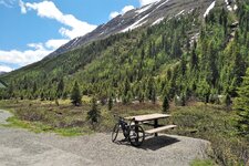
With the final destination behind us we could now set our sights on the return leg...but not before a quick snack at a picnic table at the Cirque lot.

GH011676_Highwood Pass Sign.jpg

IMG_20220708_1659595.jpg

IMG_20220708_1700274.jpg
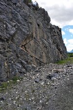
Rock fall was another hazard that could have potential consequences. The steel mesh anchored along sections of this rock wall did little to help and we had to dodge a number of large rocks that were strewn across the road.
IMG_20220708_1852280.jpg

IMG_20220708_1857320.jpg
As we neared the end of our ride we stopped by Wedge Pond. A popular day use area, it's an excellent spot for families to escape the city and head out for outdoor pursuits. The paved Bill Milne Trail can be accessed here and ridden back to Ribbon Creek/Kananaskis Village thus avoiding the short section of the main hwy back. We did exactly that as in the end of the video below.


IMG_20220708_1909060.jpg

I had a lot of fun putting this one together and hope that you enjoy the view. 🍿

 
Last edited:
I recently posted a short 40km day ride, essentially within the city limits of Christchurch (NZ). The route goes across Bottle Lake Forest Park just north of Christchurch, south down the coast and then follows the meandering Avon/Otakaro River back towards the CBD.

A more detailed description and video of the ride is on the link shown below. The short video contains an animation of the ride with pop-up location photographs.

The ride along the Avon River passes through “Red Zones” which were residential areas prior to the earthquakes of 2010 and 2011. The land is now unsuitable for housing and so all houses and associated structures were removed. All that remains is deteriorating civil infrastructure, along with trees and shrubs which were once resident’s gardens. There is a photograph of a footbridge which was across the river and mangled during the earthquakes. A section of the bridge is now installed on the bank of the river as a reminder of the forces it was subjected to that day. Three new foot/cycle bridges of eye-catching design and structurally much stronger (!) have been installed at various points in that section of the river.

The link:
Bottle Lake and Avon/Otakaro River Loop ride.

trip.jpg


20220706_134259.jpg


20220706_142232.jpg


20220706_144942.jpg


20220706_155809.jpg
 
Last edited:
I went back to the peak District to ride along Stanage Edge, which is a kerbside compared the Canadian wilderness, but obviously no bears, so is a trillion times better.
Its used by freeclimbers to practice, because of the accessibility, nearby uber cute village full of bars and cafes, and the..you might survive the fall... height.
I cant be bothered posting the pics in this heat, 24 centigrade, its like some Japanese tin hut in the sun torture here in blighty, so heres the vid.

Highlights include me falling off at the end....thats it.
 
One of these days…

I'll go for a long ride, but not yet. There's a simple formula for categorising rides:
under 50km=short​
over 100km=long​
All rides during June and July—not many!—have been 'short'. It's time to stray into the in-between grey area, methinks.

Be all that as it may, July's early mornings have been too cool:

Ipswich Weather: Bureau of Meteorology


Why ride early with frost predicted? Forget it: afternoons are near perfect.


Glamorgan Vale, SE  Queensland

Glamorgan Vale
~15 km form home; SE Queensland

The Bureau of Meteorology's symbols—moon for night and sun for day—reminded me of a recent good-humoured rant by my (everyone's?) favourite astrophysicist, Neil deGrasse Tyson: the sun's out only by day; the moon's out night and day!

So, here, for Neil, is a 'waxing gibbous' moon by day shyly peeping through some late afternoon clouds in the eastern sky above Glamorgan Vale shortly before I headed home. (Thanks Stefan for prompting me a year or two ago to take along a decent zoom lens.)

Waxing Gibbous Moon : 2022/07/10 16:02:21

Waxing Gibbous Moon
4:00 pm Sunday, 2022–07–10
 
Last edited by a moderator:
One of these days…

I'll go for a long ride, but not yet. There's a simple formula for categorising rides:
under 50km=short​
over 100km=long​
All rides during June and July—not many!—have been 'short'. It's time to stray into the in-between grey area, methinks.

Be all that as it may, July's early mornings have been too cool:

View attachment 128553


Why ride early with frost predicted? Forget it: afternoons are near perfect.


View attachment 128554
Glamorgan Vale
~15 km form home; SE Queensland

The Bureau of Meteorology's symbols—moon for night and sun for day—reminded me of a recent good-humoured rant by my (everyone's?) favourite astrophysicist, Neil deGrasse Tyson: the sun's out only by day; the moon's out night and day!

So, here, for Neil, is a 'waxing gibbous' moon by day shyly peeping through some late afternoon clouds in the eastern sky above Glamorgan Vale shortly before I headed home. (Thanks Stefan for prompting me a year or two ago to take along a decent zoom lens.)

View attachment 128546
Waxing Gibbous Moon; 4:00 pm Sunday
2022–07–10
Stunning moon shot, David!
 
Soaking in the sights at Highwood.

As promised, here is my trip report from yesterday’s ride as my wife and I cycled up the highest paved road in the country. This would be round two for me as I accompanied my BIL last September along the same route as my better half was unable to ride due to a minor back injury. Our hopes of riding up the Pass before it opened up to vehicular traffic in May were dashed once we were told by the park authorities that cyclists would not be allowed through the gates until a bear advisory was lifted.

View attachment 128497 View attachment 128496
Things would be a bit different from last season as we have been training daily riding both indoors and along local rural roads just to prepare for tougher rides like Highwood. We decided to attempt to cycle without PAS for as far as we could possibly ride. Everything was going well until we hit the final 7km at the Little Highwood Pass trailhead and a brick wall of a climb to the top. No way Jose…ain’t gonna happen as we ultimately kicked our rides into sport the remainder of the way.

The entire ride went smoothly despite a tire puncture on a fast descent on the return leg. Not something you want to happen at almost 70 kph! The severe wobble disabled my ride temporarily as I could see my wife disappear down the descent. With no time to spare (pardon the pun) I quickly pulled over and pumped up the tire to its max and carried on slowly down the remainder of the hill. To my surprise the air held but I continued to monitor the pressure and stopped a few more times to replenish it and was able to finish the ride in this manner. A 14km stretch of road leading up to and down the Pass were in severe condition with gravel and potholes evident both on the shoulder and the main road itself. I’m afraid that Alberta winters are not very kind to alpine tarmac.

Most cyclists we saw started out on the other side at the south gate and rode up to the Pass in the opposite direction. This seems like the most popular route for most but coming from Cochrane we opted for the northern out-and-back instead starting from the Ribbon Creek Day use area near the Kananaskis Village and would eventually terminate at the Ptarmigan Cirque parking lot only a mere 500 meters from the highest point.

Without further adieu, here are the remaining photos and video of our Highwood Pass trip. There was no shortage of spectacular scenery along the route. Lesser-known K-Country in Peter Lougheed Prov Park is certainly up there in terms of sheer beauty with more popular destinations such as Banff and Jasper National Parks as well as Kootenay/Yoho.

View attachment 128498
View attachment 128499View attachment 128500View attachment 128501View attachment 128502

Mountain sheep were abundant licking any remnants of salt along the road.

View attachment 128503
View attachment 128507

Magnificent view from the saddle, wouldn't you agree?

View attachment 128504

....and this one of the the mtn range near the Fortress Junction.

View attachment 128505
View attachment 128506

A stopover with a convenient bench and a view that isn't too shabby either. :cool:

View attachment 128510 View attachment 128512

Sai prepares herself for another climb up towards the Pass.

View attachment 128513
View attachment 128516

No big surprise to see snow here considering the altitude. With much of it melting, there were still trails that were closed to the public that were deemed impassable due to the deep snow pack.

View attachment 128519
View attachment 128520
Did I mention how bad the roads were? My wife hit this pothole at 60 kph and thought she had broken a wheel. o_O
View attachment 128523

With the final destination behind us we could now set our sights on the return leg...but not before a quick snack at a picnic table at the Cirque lot.

View attachment 128525
View attachment 128526
View attachment 128527
Rock fall was another hazard that could have potential consequences. The steel mesh anchored along sections of this rock wall did little to help and we had to dodge a number of large rocks that were strewn across the road.
View attachment 128529
View attachment 128530
As we neared the end of our ride we stopped by Wedge Pond. A popular day use area, it's an excellent spot for families to escape the city and head out for outdoor pursuits. The paved Bill Milne Trail can be accessed here and ridden back to Ribbon Creek/Kananaskis Village thus avoiding the short section of the main hwy back. We did exactly that as in the end of the video below.


View attachment 128531
I had a lot of fun putting this one together and hope that you enjoy the view. 🍿

Terrific video and photos. I did notice a lot of standing dead trees, though, particularly in the drone segment in the beginning, but also interspersed throughout the area as you rode along. I'm assuming that is due to beetle infestation or other diseases, which are on the rise because of climate change. (Trees stressed by heat and drought are unable to fight off infestations and infections.) Another reason to save the trees we have left and reduce logging.
 
Terrific video and photos. I did notice a lot of standing dead trees, though, particularly in the drone segment in the beginning, but also interspersed throughout the area as you rode along. I'm assuming that is due to beetle infestation or other diseases, which are on the rise because of climate change. (Trees stressed by heat and drought are unable to fight off infestations and infections.) Another reason to save the trees we have left and reduce logging.
You raise a good point. Beetle infestation continues to affect our boreal forests here. K-Country isn’t immune and park authorities have been employing controlled burns in the Bow Valley to try and limit their spread. Even closer to my home in Clearwater County (Rocky Mtn House/Nordegg) small areas of red trees can clearly be seen from along the David Thompson Hwy. That being said, Alberta Parks has invested millions in control programs and monitoring to keep tabs on infestations. It was once thought that the beetles wouldn’t survive the cold winters here but that no longer holds true as a result of changing climatic conditions.
 
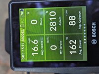
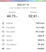
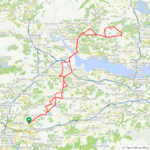
Got a nice 45 mile ride in today down around the top of Lake Washington and then up to Maltby and the Snohomish airport before winding my way back home. First sunburn of the summer!

strava7693787322596220683.jpg

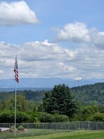
Not much in the way of scenery pictures, but I did see several curious artifacts along the way.

This wagon has a suspension seat just like my bike
PXL_20220710_195128314.jpg


I took my first break in Maltby, a tiny burg that has a nice antique shop and the Maltby Cafe which is known for it's huge gooey cinnamon rolls. It's also the home of Snoqualmie Ice Cream - the BEST local ice cream.
When your chicken is Finger Lickin' Good, I guess it makes sense that you would also be good at detecting the wind direction with your wet finger!
PXL_20220710_200246452.jpg


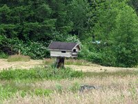
A stump house? It's hard to tell the scale from the picture, but it's a good 4-5 feet off the ground and is pretty big.
PXL_20220710_201547289.jpg

Definitely feeling the ride now, as I intended to ride in a higher assist mode, but got stubborn and kept the bike in the lowest mode the majority of the time.
PXL_20220710_212414414.jpg
 

Attachments

  • PXL_20220710_202205942.jpg
    PXL_20220710_202205942.jpg
    526.6 KB · Views: 95
  • PXL_20220710_221155016.jpg
    PXL_20220710_221155016.jpg
    636.9 KB · Views: 99
  • Screenshot_20220710-153423.png
    Screenshot_20220710-153423.png
    261.6 KB · Views: 96
  • PXL_20220710_202210137.jpg
    PXL_20220710_202210137.jpg
    323 KB · Views: 95
Got a nice 45 mile ride in today down around the top of Lake Washington and then up to Maltby and the Snohomish airport before winding my way back home. First sunburn of the summer!

View attachment 128599
Not much in the way of scenery pictures, but I did see several curious artifacts along the way.

This wagon has a suspension seat just like my bike
View attachment 128600

I took my first break in Maltby, a tiny burg that has a nice antique shop and the Maltby Cafe which is known for it's huge gooey cinnamon rolls. It's also the home of Snoqualmie Ice Cream - the BEST local ice cream.

When your chicken is Finger Lickin' Good, I guess it makes sense that you would also be good at detecting the wind direction with your wet finger!
View attachment 128602

A stump house? It's hard to tell the scale from the picture, but it's a good 4-5 feet off the ground and is pretty big.
View attachment 128608

Definitely feeling the ride now, as I intended to ride in a higher assist mode, but got stubborn and kept the bike in the lowest mode the majority of the time.
View attachment 128612
Well, your post finally got me checking out Esperance which I have seen on maps over the years. Apparently, a small section of UNincorporated Snohomish County completely surrounded by the City of Edmonds

Nice photos of oddities along the way. I have not been to the Maltby Cafe in eons. We use to park there and do big bike loops.

The problem now is go alone or take two cars since two electric bikes would exceed rack capacity.

 
@Prairie Dog That video was just breathtaking, spectacular scenery from start to finish! 👍
@Chargeride Amazing video but I was having palpatations at times with those big drops! :eek: You ride your bike where I wouldn't even dare to walk!🤣
You asked the question "who falls going uphill?" *raises hand* I managed it yesterday on my way back from the car racing, stupid mistake on my part and a lesson learned! Just a few cuts and bruises but I'm fine and very glad I was wearing a helmet as I went right over the bars...my bike is fine with just a scuff on the left brifter and some torn bar tape, I actually have new bar tape and haven't got round to fitting it yet, I guess I was waiting for this to happen!🤣Amazingly all of my cycling gear remained intact! Report coming soon...
 
I went back to the peak District to ride along Stanage Edge, which is a kerbside compared the Canadian wilderness, but obviously no bears, so is a trillion times better.
Its used by freeclimbers to practice, because of the accessibility, nearby uber cute village full of bars and cafes, and the..you might survive the fall... height.
I cant be bothered posting the pics in this heat, 24 centigrade, its like some Japanese tin hut in the sun torture here in blighty, so heres the vid.

Highlights include me falling off at the end....thats it.
Very nice video.
 
Is your rack tow bar mounted? If so, you could hire a trailer.

Alternately, instead of taking two cars, you could hire a panel van and put the bikes in the back of that. That is what we do.

View attachment 128667
Since the drive is only about 45 minutes or so, that would be overkill and expensive. I've got the two bike Kuat and it is hefty but not designed for two bikes. Well, maybe it would take two Creo's but not my friend's heavier bike. I've thought about upgrading racks but the Kuat is not that old and these darn things are not cheap. I might have to prevail on my friend for the two-car-scheme on occasion. Always biking from home really limits the options.
 
Since the drive is only about 45 minutes or so, that would be overkill and expensive. I've got the two bike Kuat and it is hefty but not designed for two bikes. Well, maybe it would take two Creo's but not my friend's heavier bike. I've thought about upgrading racks but the Kuat is not that old and these darn things are not cheap. I might have to prevail on my friend for the two-car-scheme on occasion. Always biking from home really limits the options.
I didn’t realise that it was not such a long distance.

That’s why we swapped the car for a panel van.

Two Riese and Müller eBikes are too heavy for a rear rack, plus too heavy to get on a roof mounted bike rack.

Since we got the can, we get much further afield, plus if staying overnight somewhere, the eBikes are a bit more secure, being out on sight.
 
Back