2025 - Our Rides in Words, Photos, Maps and Videos

1737394189234.png


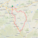
6 days ago I had zero miles for 2025, 3 rides in and I'm now on 236 miles! Quite a turnaround after a dismal start to the year, thanks to the milder weather! I set off at midday today under leaden skies and fully expected to get wet, temp was around 7C and for once we had light winds! My plan was to head down to Garrion Bridge in the Clyde Valley and head out to Strathaven but the roads were really busy heading down to the valley so I decided to take on Manse Brae and take the back roads to Kirkmuirhill! What a decision that was as the road was totally free of traffic for the most part, its a tough old climb but it was more than worth it! Its actually a road I usually avoid in winter as it usually has a river of water running down it and its well known for ice but with the temp well above freezing all was good today!

When I reached Kirkmuirhill I decided to give Strathaven a miss and elected to head south to Uddington and take the A70 north through Rigside and on to Lanark! After passing through Uddington the skies cleared a bit and I could even see some blue sky, that was a welcome surprise!

I wasn't going to take any photos due to conditions but I couldn't pass up the opportunity with the skies clearing! The A70 just after Uddington, the road then climbs steeply up into Rigside!

1737399066241.jpeg

1737399081008.jpeg

I continued up the climb and reached the summit and enjoyed some lovely descents, its such an amazing road and I was glad I made the decision to go this way instead!

I even got some sun!

1737399269749.jpeg

1737399293848.jpeg

You can see why I love this road, a lovely fast descent followed by a slow climb!

1737399320532.jpeg

1737399344167.jpeg

That was a tough climb but more descents were just ahead! I kept stopping for more photos...

1737399470078.jpeg

1737399510894.jpeg

1737399561318.jpeg

The River Clyde to the north!

1737399598262.jpeg

1737399608285.jpeg

I then plunged down the fast descent to Hyndford Bridge and stopped on the bridge for a few photos!

1737399665623.jpeg

Just to the right of my bike you can see a stone on the path here, believe it or not it almost ended my ride...as I walked back to the bike I was distracted by the swans and stood right on top of it and almost landed in the middle of the road oops! 😂 I thought I had sprained my ankle at first but luckily I got away with it, it is a little painful now but I will survive!

1737399861064.jpeg

1737399880439.jpeg

The big descent I had just hurtled down at close to 40mph, the photo doesn't do it justice!

1737399923390.jpeg

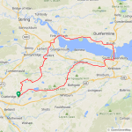
I then had the big climb up to Lanark but part way up I took the road to Carstairs Village to avoid the busy town, another great road but I was surprised to see lots of trucks on it today! After passing through the village I took the quiet back road which passes the Alpaca farm, it starts with this big climb!

1737400687954.jpeg


Then this lovely twisty descent!

1737400706070.jpeg

A short time later I reached the Alpacas!

1737400723996.jpeg

1737400736840.jpeg

1737400752843.jpeg

1737400763232.jpeg

I then headed up the climb past the farm and took another quiet back road that eventually joins the road to Forth, it has some nice twisty parts and although the road is a bit rough in places it was at least dry and at the end of the road there is a big fast descent which is quickly followed by this climb up towards Forth!

1737401001177.jpeg

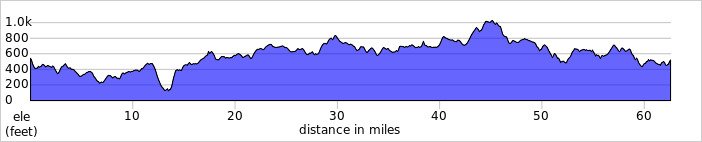
Time was getting on now so it was time to get my head down and stop taking photos or I would have arrived home in darkness! At Forth I took the back road up to Climpy, another tough climb but the road was resurfaced last year and was still in excellent condition! After the climb which goes up to just over 1000ft the road plunges down into the valley, that was a real blast! At the end of the road I was intending to take the road to Shotts but it was closed so I had to join the main road for a mile or so before taking the alternative road into Shotts!

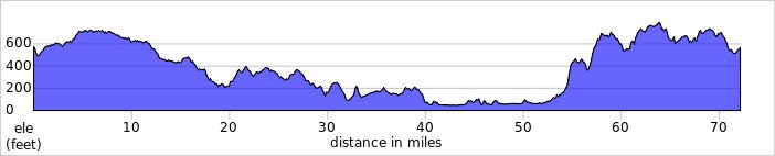
From Shotts I took the back road to Hartwood, its such a fun road with very little traffic and lots of fast descents! At Hartwood I took the back road up to Hareshaw, time to start climbing again and then another awesome descent through Hareshaw where I joined the cycle path up to Salsburgh and then the back road to my home town! I used this road recently and it had 3" thick ice in some parts but it was fine today thankfully! Another fantastic day on the bike and no rain which was a bonus, no range anxiety today thankfully but still lots of elevation gain!;)

Has anybody heard from Art, @Prairie Dog he seems to have disappeared this year? I hope all is ok mate, maybe the weather is doing its worst over there but hopefully you and Sai are doing okay!🤞
 

Attachments

  • elevation_profile371.jpg
    elevation_profile371.jpg
    23.2 KB · Views: 24
  • trip-248795706-map-full371.png
    trip-248795706-map-full371.png
    472.7 KB · Views: 24
I'm torn where to ride on Saturday. We have the biggest annual charity event this weekend, translated to The Great Orchestra of Holiday Aid (WOŚP). One of the events is "The Big Heart for WOŚP", which means riding along a heart shaped route in the Kampinos National Park (and donating to the charity). As the idea is nice as I am not convinced I'd like to ride off-road again (despite the promised fairly warm weather), especially as I am afraid part of the ride would lead through singletracks, which is illegal in the Park.

I'd rather donate to the volunteers in the City and make an interesting Warsaw ride: "The Warsaw Ghetto and the Saxon Axis" with taking many pictures instead. I'll make the decision on Saturday's morning!

The plan for Sunday is easier to make. I often wondered what happened to the "temporary" Warsaw Mermaid Bridge (1985-2000). Turns out, the military bridge construction was brought to a small village in my "great neighbourhood" (a fact that is only known to a few people). Could be an interesting trip, partly by train. Or... Warsaw again. There are so many interesting places in the city I was born and raised in I had no idea about!
 
Last edited:
I may have missed it, but where’s Prairie Dog? It doesn’t look like he’s been on here since November. I hope everything is ok.
We decidedly should interact on more than a single social medium. I welcome EBR users to Strava (at least) and FB is not a bad idea either...
If I can remember, the last message from Art was during or just after the Japan trip?
 
A belated report of my first ride of 2025 — a magical 6 miles on North Ponto and South Carlsbad State Beaches in dense fog.

Screenshot_20250124_205556_Ride with GPS.jpg

The morning of January 2 brought an end to 2 straight weeks of all-day marine layer fogs and low cloud decks. Finally, sun on the water and a sharp, clear horizon for a change! Gotta get the hub-drive onto a beach ASAP!

20250101_081043.jpg

Well, things kept coming up, and by the time I was ready to roll out, our little side canyon off Bataquitos Lagoon had already refilled with dense fog. Dang! It could only be thicker at the beach, but goin' anyway.

20250102_145924.jpg
20250102_145955.jpg

And thicker it was. These shots — looking first south then north from my southern turn-around halfway down South Carlbad State Beach — don't really do it justice.

20250102_150352.jpg

But that low visibility turned out be a big part of the magic! Hard to put into words, but quite an otherworldly experience to ride along with barely visible surf crashing on one side, barely visible sea cliffs looming above on the other, and now and then, treacherous patches of dark, sand-free beach cobble suddenly appearing out of the gloom ahead.

20250102_150200.jpg

Had to turn around here for one simple reason: Ran out of sand. My 2.3" hybrid tires require a certain amount of intermixed sand to keep the rounded cobbles from acting like ball bearings under the weight. With very little sand visible farther south, walking or falling were the only 2 options I could see in that direction.

20250102_150052.jpg

A bike-friendly mix of sand and cobble. Keeping my distance from surf I could barely see meant riding farther upbeach than usual. And at 2 hours past low tide, that put me in drying sand that was also getting too squirrelly for comfort. But mixing in some cobble as shown kept it rideable. Following this blend without getting too close to the water got tricky at times.

20250102_160516.jpg

The fog was as chilly as it was thick, but there were more hearty beach goers than expected — perhaps locals who already knew about the foggy beach magic I'd just stumbled onto.

20250102_154106.jpg

20250102_154132.jpg

Ran out of sand at my northern turn-around below Terramar Head as well. When sand fully buries this narrow stretch of beach in summer, my commuter has no problem getting across at low tide. But with most of the sand now in its winter residence offshore, a slippery platform of wildly eroded mudstone had been exposed. A highly skilled MTBer might well be able to cross this on the right bike, but I'm not your man.

20250102_154251.jpg

Mind you, relentless attack by sand- and cobble-laden waves and their backwashes carved all of the surface structures seen in the last 3 photos and below in hard rock, not in sand. This day's dense fog and diffuse lighting brought out the bizarre shapes and textures in a way I'd never seen. Below are some favorite shapes.

20250102_154440.jpg

This slow but steady sculpting took place over the thousands of years since the last Ice Age and continues to this day. Result: A fantastic mini-landscape of variably connected basins, meandering channels, and linear grooves straight out of a surrealist painting. This marine mudstone (part of the 40-45 million year-old Del Mar Formation) erodes in this same odd way wherever it's found in or near the surf zone.

20250102_154333.jpg

20250102_154313.jpg

20250102_154357.jpg


20250102_155047.jpg

Remnants of the summertime sand blanket still covered parts of the mudstone bench.

20250102_160346.jpg

Enjoyed this Zen experience so much that I did another iteration before leaving the beach via this steep rutted ramp leading to the Coast Highway at North Ponto. Very glad to have had walk mode to help me get the 70 lb hub-drive back up to the road.

20250102_162339.jpg

The hub-drive took on more sand and salt on this ride than I've ever allowed before. Definitely needed a thorough rinse back home.
 
Last edited:
1737828896360.png


I managed to get another ride done last Wednesday but had no internet to post about it, it wasn't the nicest day but I decided to set off into freezing fog and hope it would clear up! Luckily the fog lifted after only 8 miles but soon after the mist rolled in and it was bitterly cold! For a change we had an easterly wind, only around 10-15mph which was a nice change from the crazy winds we had been experiencing! I decided to head east and cross the Forth Road Bridge, the ride into the wind was so cold and the difference after I crossed the bridge and turned west was remarkable and it sure cheered me up on a dreary day!

I was using main roads on the way out due to possible ice on the back roads but on the way back the temp had risen to 4C so I enjoyed using the back roads all the way to the Kincardine Bridge where I turned south for home, using back roads all the way with no sign of any ice! All of the climbing in the last 20 miles had me nice and toasty and I was pleased I decided to chance it, I needed 64 miles to hit 300 for January and ended up with 308 miles! Quite a turnaround after having zero miles mid month...no photos this time as it was too cold and way too dreary!

Yesterday was just insane with wind gusts around 90mph, I dodged a bullet this time and only lost 1 roof tile...my next door neighbour wasn't so lucky as they lost several this time!
 

Attachments

  • trip-249162471-map-full372.png
    trip-249162471-map-full372.png
    487.4 KB · Views: 10
  • elevation_profile372.jpg
    elevation_profile372.jpg
    22.3 KB · Views: 12
Im.considering changing to the DJI action 5 cam, so watched a lot of reviews.
Not one mentioned that you need to download an 800mb Mimo app that isnt registered on any app stores, setup your phone to accept non secure software and then have another 1GB to unpack it.
Then you need an account to use the camera.
This off the back of the US trying to ban tiktok and here I am loading another uncertified chinese app.

Where is all this crp heading...an app and an account to use a camera.
An 800mb app!
 
Warsaw: The Jewish Quarters and The Saxon Axis
I apologise for a big number of photos and extensive text in this post.

My curiosity about what the pre-WW2 Warsaw was (and what has changed since) has been rekindled lately. With the advantage of exceptionally good weather on Saturday, I did a slow meticulously planned ride with many stops for photos.

A Historical Note
Warsaw was a densely populated city before WWII, and a big number of inhabitants were Jews, mostly living in extreme poverty. Most of blocks of flats had no basic amenities such as toilets or running water! Tightly spaced buildings made the air hard to breathe. For instance, Warsaw Old Town we are so proud of today was ugly and inhabited by the poor.

Following the German Nazi occupation of 1939, and the racist ideology, the Nazi resettled and separated the Jewish populace inside the Ghetto, which was cut from the "Aryan" side by walls. Jews were denied all rights and were gradually transported to concentration camps to be killed there. As the Warsaw Jews realized they were doomed, they started an armed uprising in April and May 1943. Almost all population of the Getto was killed, and the Jewish quarters were totally razed to the ground.

A similar fate was met by the Polish population of Warsaw following the Warsaw Uprising 1944 (but many have survived the evacuation), and the majority of the city was burned and exploded, leaving the sea of rubble.

Only the iron will of the returning Warsawers combined with an enormous effort of the whole nation resulted in the reconstruction of Warsaw. There are a few old things in Warsaw: It is either reconstruction or new construction or the latest construction. Yes, some artifacts have survived as those were hidden by the people of good will early enough.

1737933646929.png
1737933724604.png

The Museum of Warsaw Uprising 1944 is located in the building of the former Powerplant for Warsaw Trams. It is on the former "Aryan" part of the city.

1737933889251.png

Entering the Jewish quarter, Chłodna (Chilly Street). The original rough cobblestone and old tram rails have been left in many places of the Jewish quarter for historical accuracy. I was born in 1961, and for many years could not really understand why such a big part of that area was still in ruins. (The side of the street was occupied by makeshift private workshops, which have gradually disappeared).

1737934137978.png

1737934157986.png

The most shocking place. Chłodna was a relatively narrow street where a tram and a car/horse-drawn cart could barely fit side by side. As the street was on the "Aryan" side, it was flanked by brick walls that contained the Jewish populace, with a wooden gangway connecting both parts of the Ghetto. The Gangway Memorial is not historically accurate but it correctly marks the location.

1737934515874.png

The westward view onto Chłodna. You can see a Catholic church there ("Aryan" side). The building on the right was already inside Ghetto.

1737934703259.png

Former buildings of the Royal Horse Guard (Mirów division). It is one of the building that was reconstructed post WWII, and it is a home to a fire station today.


1737934434477.png

This is an exceptionally interesting photo! (No other photographer could spot that?!) Guys: this is a 10x zoom photo of the reconstructed Jabłonowski Palace from the distance of 1,250 m (around 4,200 ft). The perspective was totally shortened! The shot goes through whole Elektoralna, Bank Square and Senatorska to the Theatre Square! How could it be even possible?!

1737935115145.png

I intend to talk about the Saxon Axis now. Poland had two elected Saxon Kings in a row by 1763. The royal architects planned the Park to be located on a certain Axis. Turns out, the Saxon Axis (as a concept) eventually continued to Mirowska Market Hall! You can see a part of the City and Pope John Paul II Avenue (this artery didn't exist before WW2!)

1737935490374.png

Following the Saxon Axis, I arrived in Plac Żelaznej Bramy (Square of The Iron Gate). If you turned your back, you would see a small patch of grass between two lanes of Marszałkowska artery: there stood the Iron Gate to the Saxon Garden! The monument is for Thaddeus Kosciuszko, a Polish and an American hero. There is an exciting history of the Lubomirski Palace (background). The palace was rebuilt by 1950. However, someone important in the Communist Party didn't like the arrangement in 1970. It took one and half month to rotate the palace by 74 degrees to visually close the Saxon Axis!

1737935961790.png

This gem, Janasz Palace is located in the City Centre! Partly damaged during WW2, rebuilt in 1970, taken care of by 2007. Take my word: there is a huge empty space in the front of the palace. There had to be buildings before the war! (I could not just cross Marszałkowska so had to make a detour to return onto Saxon Axis).

1737936155524.png

Inside the Saxon Garden. It was made for our first Saxon King August II The Strong, and made public as early as 1727! The park was fenced. You had to look decent and pay an admission fee to get inside the Garden! (No way a working class person could be admitted there!) One of interesting buildings: a water tower by Henryk Marconi (1855). Marconi waterworks were a shame, as the Vistula water was drawn from the place where all the litter was dumped into the river! Warsawers had to wait to 1886 when a Russian Governor Socrates Starynkiewicz (one of the best mayors we had!) called in Englishmen by name Lindley to build proper waterworks for Warsaw.

1737936538654.png

Allegory of Medicine here. The Saxon kings ordered some 70 sculptures of Allegories for the Saxon Axis. In those times, the Allegories were obvious for a medium educated person. Later, the captions were added, and I can tell you many of the captions are wrong! (21 sculptures survived by this day).

1737936719649.png

A Saxon fountain, an Allegory, the Tomb Of Unknown Soldier, and Marshall Józef Piłsudski square, all on the Saxon Axis.

1737936800996.png

The most solemn place in Warsaw: The Tomb of Unknown Soldier.


Necessary to mention the Tomb is the only surviving part of so called Saxon Palace.
There is an ongoing controversy. The previous parliamentary majority (2021) voted to "reconstruct the Saxon Palace in the shape of 1939". As you might guess, it was a purely populist decision. The point is, the 1939 shape of Saxon Palace was decreed by one of the bloodiest oppressors of the Polish nation, Russian General Ivan Paskevich in 19th c. Do we need it? Certainly not!

1737937283695.png

A placard for the original design of the Saxon Axis of 18th c.

1737937474628.png

Cracow Suburb Street. Originally, Warsaw was a very small medieval city, Since royal elections in Warsaw, and especially after moving the capital city from Cracow to Warsaw by King Sigismund III Vasa in 1596, more and more rich people wanted to settle there. The early quarters (or rather big lots of land) were called "jurisdictions", each with own law and management. Historically, you could travel to Cracow following that (dirt!) street, hence the Cracow Suburb. Seen from the left: Warsaw University, Staszic Palace, Holy Cross Church, Academy of Fine Arts, House Without Corners.

1737938027889.png

Potocki Palace in Cracow Suburb (northwards view). During this season, and weekends, only public transportation including taxi, and bikes are allowed here.

1737938140655.png

The Castle Square of Warsaw (Old Town). The Sigismund III Vasa Column (1644) was the first secular monument in Europe of that era! That brought an unpleasant reaction of the Church, as only religious figures were allowed before!

1737938293454.png

I had to descend via Coopers Street very very slowly... :D (See the cobblestone?)

1737938369313.png

St. Anna Church (1667) as seen from Mariensztat (City of Mary) below. The church was reconstructed soon after the Swedish Deluge war, which was the first step towards future demise of Poland as of a country.

1737938499194.png

I'm sure you can see nothing interesting here, and you are right! Were you, however, living in Warsaw in 1572, you could walk (toll-free!) to the other side of the Vistula by the Sigismund August and Ann the Jagiellon Bridge there!

1737938683437.png

Now, I had to climb the Bridge Street towards New Town (on the cobbles, of course).

1737938742210.png

The Old and New Town were totally reconstructed post WW2. However, the architects of the era reasoned: "We know Old Town was ugly and extremely poor before 1945. There is no point to reconstruct the bad design. As we have a clean slate now, let us reconstruct the place
not historically accurately but let us choose the best design from the golden era!" So they did. For instance, there was a Barbican in 1548 but it was demolished later. Here, the deliberate reconstruction of the Barbican to make the place beautiful.

1737939142216.png

I was riding back via Long Street (cobblestone, of course!) Here, Krasiński Palace and the green portal of The Supreme Court. The portal has a hidden meaning. My Dad told me a Jewish building was blocking passage before 1937 there. Stefan Starzyński the mayor ordered drilling a gate through that building and further expanded the road towards north.

1737939344097.png

Blue Skyscraper near Bank Square. The place hosted the Grand Synagogue (Reformed) before WW2. Later, a Yugoslav company tried to build a skyscraper there, and actually they did it, in golden colour but for reasons unknown to me, the building stood unfinished for twenty-five years! An urban legend says it was necessary to include a synagogue to relieve the curse. It was done, eventually.

1737939619600.png

Hard to believe it now but this narrow street called Nalewki was an artery with elegant stores and teeming with life before WW 2. It was because high density of the urban structure made any traffic very complicated. Arsenal on the left. The new building occupies a part of the lot of Simons' Passage, an elegant Jewish department store we could name "the Harrods of Warsaw".

1737939815992.png

The history of the Jewish quarters ends here. As I said NOTHING was left of the Ghetto except the rubble. As people had to live somewhere post war, the housing construction effort started exactly in the Northern Jewish Quarter, erasing all the past except 3-4 Jewish Memorials (including the new Polin Museum for Polish Jews).

1737940085165.png

This area has erased all the Jewish past.


1737962144599.png

The long shot and the Saxon Axis.

I will stop my report here (it has been long enough!) As I was returning home, I felt unwell. Yes, I caught some virus and have to live with it for a while!
 
Last edited:
Beautiful pictures of gorgeous places in Poland, I would never of known of the exact history, just guesses from general knowledge.
My take is the naivity to presume some score has been settled, or that any of us were really the good guys.
You could remake chitty chitty bang bang in Poland
 
Back