2020 : Our Rides in Words, Photos & Videos

  • Thread starter Deleted member 18083
  • Start date
owe you a Żywiec or a Tyskie
Randall, my religion prevents me from drinking the International Pale Lager :D I might treat you with craft beer in Poland, and yes, it might be Lager.
(When I paid my single visit to Canada, Sunshine Coast in BC -- there actually a bear happened; it raided my hosts' larder. I can say a word or two of the Canadian bear!)
:-D
I pretty well only drink craft beer now - but those are the two Polish beers I know (and may have consumed in moderate+ quantities).

The Sunshine coast is beautiful - I had a few projects over there when I was still working.
 
Nice day for ALmost 20 miles on the Cascade Trail in Skagit County, WA, heading towards the Cascade Mountains along the Skagit River. We drove the bikes over to the "Gateway to the North Cascades" logging town of Sedro Woolley, and parked at a trail head about 2 miles east of town to begin the ride.

IMG_20200708_115451714.jpg


The trail runs about 20 miles, from Sedro Woolley to the town of Concrete, but for a round trip we wanted to do a total of 20 today, so decided to ride as far as Hamilton - about half way - and back.

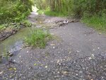
It's mostly dirt/packed gravel, except for a section that is the pebble bed of Wideman Creek (with the creek running through it). Rode most of the section, but walked the bikes across the water. Just cause we didn't want to get splashed.

IMG_20200708_113619070.jpg


There's also a rip-rappy loose gravel section of rebuilt bank where the river flooded at some point, a bit before Hamilton.

The views along the river were lovely, though the Cascade Peaks were hidden in the clouds

IMG_20200708_115334540.jpg

IMG_20200708_115522327.jpg


IMG_20200708_134839597.jpg


We stopped for lunch at the local cafe/store at our turnaround point, the little town of Hamilton.

IMG_20200708_125118420.jpg
A few folks came in to the cafe without masks (our Governor had mandated them in all public indoor spaces), but we wore ours to order, then ate outside.

Heading back towards Sedro Woolley, we decided to ride from Hamilton back to the town of Lyman along the old Lyman-Hamilton highway, to have a break from some of the bumps. Not much traffic, and the speed limit is 35, so even though the shoulder is minimal, the riding was nice.

After getting back on the trail, we stopped to read up on conservation efforts along the river:

IMG_20200708_135210108.jpg

IMG_20200708_135228178.jpg


Who knew blackberries were a bad thing :rolleyes:?

Walked the bikes back over the creek, then hopped back into the saddle for the push back to the car. There are nice benches, but zero "facilities" along the way - you have to detour into one of the towns, or take a cross street out to Route 20 to find those

IMG_20200708_113426197_BURST000_COVER.jpg


While lunching in Hamilton, we spotted another SOB couple on their electric bikes. They passed us going in the opposite direction on our return ride - he on a Specialized, and she on a Liv (I think). Apart from them and a few acoustic riders, we pretty much had the trail to ourselves.

We were aiming for 20 miles, and we nearly made it! If I had checked my app before putting the bike back on the rack I surely would have ridden another .3 to make it even! All in all, a nice, scenic, just about flat little ride. I was hesitant about taking the La Free on the gravel and through the mud, but it performed well (and, no flat tires!).

Screenshot_20200708-172714.png


BTW - stopped at the bike shop on the way home to finally get the firmware update - it took about 10 minutes. But, guess what? The #@+!& App won't see that it's been done!!! I'll try uninstalling and reinstalling AGAIN, and keep my fingers crossed. I still have access to the back version of the app, but an afraid it won't work with the updated firmware. We shall see.

This bike is such a joy, but Giant's app is crap...
 

Attachments

  • IMG_20200708_113619070.jpg
    IMG_20200708_113619070.jpg
    876.8 KB · Views: 297
Last edited:
Nice day for ALmost 20 miles on the Cascade Trail in Skagit County, WA, heading towards the Cascade Mountains along the Skagit River. We drove the bikes over to the "Gateway to the North Cascades" logging town of Sedro Woolley, and parked at a trail head about 2 miles east of town to begin the ride.

View attachment 58310

The trail is mostly dirt/packed gravel, except for a section that is the pebble bed of Wideman Creek (with the creek running through it). Rode most of the section, but walked the bikes across the water.

There's also a rip-rappy loose gravel section of rebuilt bank where the river flooded at some point.

The views along the river were lovely, though the Cascade Peaks were hidden in the clouds

View attachment 58305
View attachment 58306

View attachment 58307

We stopped for lunch at our turnaround point, the little town of Hamilton.

View attachment 58315 A few folks came in to the cafe without masks (our Governor had mandated them in all public indoor spaces), but we wore ours to order, then ate outside.

Heading back towards Sedro Woolley, we stopped to read up on conservation efforts along the river:

View attachment 58308
View attachment 58309


Who knew blackberries were a bad thing :rolleyes:?

Walked the bikes back over the creek - the trail is out and back, though it's possible to (and we did) ride on the nearby road for a bit if you want a break from the bumps ;)

View attachment 58311

We were aiming for 20 miles, and we nearly made it. If I had checked my app before putting the bike back on the rack I surely would have ridden another .3 to make it even! All in all, a nice, scenic, just about flat little ride. I was hesitant about taking the La Free on the gravel and through the mud, but it performed well (and, no flat tires!).

View attachment 58314
How deep was the creek? Looks nice. We have to Charger3s arriving in a few weeks. Would like to ride in the Valley over a few days and spend the nights at some local hotels.
 
How deep was the creek? Looks nice. We have to Charger3s arriving in a few weeks. Would like to ride in the Valley over a few days and spend the nights at some local hotels.
Just a few inches and a couple of feet wide in two places today, but after a big rain the whole creek bed can become impassable.
 
Hey @RabH, only a Scot could say 14°C was perfect weather in July 😄
So true! 🤣 We are used to cool weather, the heat just kills me!;)

Another lovely ride today although it was a little rushed due to commitments, all my photos were taken at the same spot due to the time constraints! Not much to report other than a truck on the narrow single track road I got my last puncture on, this time I stepped off the bike and made sure my tyres didn't pick anything up!

1594290897048.png
 

Attachments

  • elevation_profile168.jpg
    elevation_profile168.jpg
    21.7 KB · Views: 290
  • trip-52167658-map-full80.png
    trip-52167658-map-full80.png
    438.7 KB · Views: 324
  • 20200709_090554.jpg
    20200709_090554.jpg
    488 KB · Views: 306
  • 20200709_090557.jpg
    20200709_090557.jpg
    455.4 KB · Views: 295
  • 20200709_090559.jpg
    20200709_090559.jpg
    468.8 KB · Views: 294
  • 20200709_090601.jpg
    20200709_090601.jpg
    482.1 KB · Views: 313
  • 20200709_090603.jpg
    20200709_090603.jpg
    510.1 KB · Views: 295
  • 20200709_090605.jpg
    20200709_090605.jpg
    513.5 KB · Views: 304
  • 20200709_090607.jpg
    20200709_090607.jpg
    517.3 KB · Views: 298
  • 20200709_090609.jpg
    20200709_090609.jpg
    473.5 KB · Views: 305
  • 20200709_090611.jpg
    20200709_090611.jpg
    476.3 KB · Views: 292
  • 20200709_090626.jpg
    20200709_090626.jpg
    698.3 KB · Views: 299
  • 20200709_090650.jpg
    20200709_090650.jpg
    573.4 KB · Views: 294
  • 20200709_090702.jpg
    20200709_090702.jpg
    635.9 KB · Views: 297
All my photos were taken at the same spot due to the time constraints!
RabH…
What a place to ride. I hope you don't mind my joining the photos together!

As you look straight down the road, the left edge of the panorama would be behind your left shoulder.

To view at a larger size: click the image to open in a new window and then click the + symbol inside the magnifying glass.
…David
20200709_090554-pano-aaa.jpg
 
Last edited by a moderator:
RabH…
What a place to ride. I hope you don't mind my joining the photos together!

As you look straight down the road, the left edge of the panorama would be behind your left shoulder.

To view at a larger size: click the image to open in a new window and then click the + symbol inside the magnifying glass.
…David
View attachment 58360
Of course I don't mind David, great work joining the photos! ☺ I really am blessed to have such amazing roads on my doorstep!
 
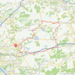
Rainy day yesterday, but today weather turned to be more friendly at the end! We did a little 20km tour in what's called here: "La Burdinale". At the end an ice cream man crossed our way and we could not resist a delicious "Dame Blanche" (vanilla ice cream and hot chocolate poured on it). Heat wave forecasted for next week :cool:

IMG_20200709_172506739.jpg
IMG_20200709_171927307.jpg
IMG_20200709_174525731.jpg
 
I was doing 48mph last week, I was slow this time! :p I love descents, especially this one which is very close to home! Have a look on Google Maps!


Descending is an important cycling skill... and a ton of fun if done correctly! What is your max recorded? ;)
 
Hi all, my wife and I are from Belgium, we hiked for many years: backpack, tent, Peru, Annapurna, New Zealand, Alaska, Scotland…
Welcome JP. We look forward to more photos of your ebike adventures.
…David
 
Descending is an important cycling skill... and a ton of fun if done correctly! What is your max recorded? ;)
Last week I posted a picture of Burnt Pond. On the way back from there was a section of downhill road where I hit 40 mph. That is the fastest I have ever ridden. Although somewhat exhilarating, I was more concerned about a deer, squirrel or even a chipmunk running out in front of me, not to mention potholes. At that speed I doubt I would be here to tell the story.

This evening I rode up to Beaver Pond, also in the Adirondack Mountains. No motorized boats allowed. The road up there is riddled with potholes, which make for some interesting maneuvers. In the second picture the sun is just behind the mountain, hence the darkness.

98E4EBA3-AE38-40DD-BC15-98E3F8869B53.jpeg
16E09AA0-3132-4873-8671-0A98B7863080.jpeg
 
Last week I posted a picture of Burnt Pond. On the way back from there was a section of downhill road where I hit 40 mph. That is the fastest I have ever ridden.

Although somewhat exhilarating, I was more concerned about a deer, squirrel, or even a chipmunk running out in front of me, not to mention potholes.

At that speed, I doubt I would be here to tell the story.

View attachment 58402View attachment 58403

Well done!
 
Last edited:
Last week I posted a picture of Burnt Pond. On the way back from there was a section of downhill road where I hit 40 mph. That is the fastest I have ever ridden.

Although somewhat exhilarating, I was more concerned about a deer, squirrel or even a chipmunk running out in front of me, not to mention potholes. At that speed I doubt I would be here to tell the story.

This evening I rode up to Beaver Pond, also in the Adirondack Mountains. No motorized boats allowed. The road up there is riddled with potholes, which make for some interesting maneuvers. In the second picture the sun is just behind the mountain, hence the darkness.

View attachment 58402View attachment 58403

I just did a double-take on your photo and noticed your bike has rim brakes... your 40 mph descent is even more impressive!

1594356850877.png
 
Last edited:
Back