2020 : Our Rides in Words, Photos & Videos

  • Thread starter Deleted member 18083
  • Start date
The Meanders of River Rawka

I completely missed the fact last Thursday would be the Feast of Corpus Christi in Poland, a holiday. My fridge was almost empty, beverages and ride snacks to be bought at the gas station, etc. I took a day off at work and drove to Puszcza Mariańska to further explore the Bolimów Landscape Park and beyond. At last we had warm weather, pleasant wind helped ignore humidity but the ground was soaked with rainwater and the trails and tracks were full of deep puddles with no way around; just the perfect environment for my Monster. I was eager to test my new Sony RX100 VII camera.

View attachment 55211
The route plan was to ride paved roads only where it was absolutely necessary. From that point on (around the 8th kilometre from the start) it was mostly off-road riding.

View attachment 55212
The first part of the ride followed tourist trails with easy terrain (nothing was easy after heavy night raining though). I had already been on some of those trails before. For example, I could find the place where I had that spectacular fall while jumping over a trench on the "Trail of Bygone Manor Houses"; the internet/phone company had completed their work and the trail was ride-able again.

View attachment 55213
The Polish rural folk are deeply religious. There are numerous wayside shrines and places of the cult to be found even deep in the woods.


View attachment 55231
I found the new camera was perfect for nature close-up photography. Although my longer stops were rare that time, I was often stopping for taking photos.

View attachment 55215
There are as many as two villages by the name of Jeruzal in Poland: This one in the Łódź Land and another one in Mazovia. The history was always the same: To attract visitors (and to improve business), the locals named both villages Jeruzalem; that didn't help though. Both locations were later renamed to Jeruzal. The iconic view: a larger Polish village has to include a grocery store (or two) and a church.

View attachment 55216
The Feast of Corpus Christi has to involve one long procession around the parish. I was too late out for that. Here, people gathered at the Holy Mass service.

View attachment 55217
Corn-flower, one of the most often found Polish wild flowers; the other one being the poppy.


View attachment 55218
Quite unexpectedly, I rode into a bee-yard. A beekeeper brings the bee-hives into a meadow so the bees can feed in the warm season. I just missed my way: the tourist trail diverged to the right to become a single track and I rode ahead.

View attachment 55219
To my delight, me and Monster found ourselves on a track. Completely overgrown with grass, muddy, and wet (full of puddles). What a pleasure of riding there!

View attachment 55220
Then, we both rode among the fields. Occasionally, a hunting pulpit could be seen. The area was teeming with wildlife. Here, a big hare jumped in front of the Monster's front wheel and disappeared in the woods. There, a pheasant shot up in the sky when I was negotiating a puddle.

View attachment 55221
A field road. The road even had a name! You would have never guessed the name of that very road. It was the "Field Rd." :D

View attachment 55222
The midpoint of the trip. The village of Babsk (translated to "Place of Hags (or, of Countrywomen)") -- population of 690 -- is known from the fact it is split into two by the S8 expressway.


View attachment 55223
There was no easy ride from that point on. I intentionally resigned from moving along tourist trails and plotted a route along paths/tracks. It was a long exciting ride with an occasional...

View attachment 55224
...military range :D The Army cannot of course put a remark "Hey, we have a range here!" on a tourist map. Instead, there was a sign: "Military range. By entering here, you put your own life at risk". I assumed they wouldn't be shooting on the holiday :D

View attachment 55225
That was the most exciting part of the trip. I found (on the map) a path leading along the River Rawka, in a nature reservation. The River Rawka is strongly meandering there and that's a gorgeous view. Unawares, I entered a 4 km single track which was... a grass-overgrown morass. I had to fight to survive. I told my Monster: "My trustworthy steed: We must not lose the momentum. MOVE ON!" Oh my, that was fun to ride for dear life...

View attachment 55228
The Meanders of River Rawka. The dreaded 4-km ride segment.

View attachment 55226
When we both emerged from the swamp, we were both so tired we fell on the ground to take a long rest. Monster was so tired it fell on the drive-side :D

View attachment 55227
Monster and me rode any imaginable type of terrain on that day. Except the rocks.

View attachment 55229
Rambling through the fields. The way lost again.

View attachment 55230
A briar flower.

View attachment 55232
Cows, murderous beasts! I didn't really know what to do next until a shepherd approached the cattle.

View attachment 55233
"Dirty MTB is a happy MTB" :)

View attachment 55234
The ride map and stats.
Your country is beautiful. Thanks for taking us along with you! 🚴‍♀️
 
Shakedown Cruise

Yesterday’s adventures were: 1. Get back on my bike after many months of not able to use it; find out if I retained fitness enough to make a ride. 2. Try out my companion’s brand new Riese and Muller Vario as first time transition from her e-trike. She had not ridden this bicycle since taking it home from the dealer three months ago.

Mission accomplished. Not without both parties experiencing some trepidation about what would happen.

What a day to be out riding! Weather perfection comes in many flavors and this was one of them. Call it vanilla. The launch was at Edwards Ferry, upstream on the Potomac some thirty miles above Washington, DC. First leg to use the towpath of the C&O canal to reach Whites Ferry. The US Park Service had in recent years converted this few miles of trail from a muddy, rutted sad remnant of the towpath to a smoothly almost paved-like surface. There would be nothing to interrupt our exploration of our bikes, no cars of course, or anything else of concern. Interestingly, we noted an unusual number of cyclists on the towpath—unusual because this was an ordinary week-day. Must be the Corona lifestyle effect.

Here, I should report that neither of us experienced difficulties riding, and instead were joyful in the experience along this delightful stretch. It was all level through mostly woods with occasional views of the river off to the left. Not so grandly scenic as we often see from photos from the contributors here on EBR, but still worthy as exceptional cycling.

We found a picnic table for our sandwiches that overlooked the General Jubal Early ferry hauling cars across the Potomac between Maryland and Virginia. We considered going across ourselves, but decided to stick with the plan to return to our car via a remote road through the Montgomery County Agricultural Reserve.

Now this became another kind of bicycling. Farmland. Packed gravel. Vistas of early-growing crops that extended way over to the Virginia palisade along the Potomac. Wooded stretches. Only one car crept past us the whole way, its dust wafting off to the side. As a city slicker I was taken by the crops that we only see in supermarkets. Growing right there beside us. I had to take a picture of some “bountiful wave of grain” that existed only in imagination. What is this? Wheat? Oats? Rye? We city slickers are so ignorant.
View attachment 54944View attachment 54945View attachment 54947View attachment 54948View attachment 54952View attachment 54953
On return to the car, we had covered fewer than a dozen miles. I was happy to note that months lacking pedaling exercise wasn’t debilitating. Well, even though this whole foray had been over level ground, I was a bit tired. Not too bad, I convinced myself. My companion nicely “mastered” bicycling while becoming acquainted with the complications of ECO-TURBO along with variable ratios of gears.
Congrats on biking and what a delight it is to see the new R&M on the path. Great story!
 
A bend in the river …
2020-06-12-094816-2400-gb10.jpg

Twin Bridges, Brisbane River
It was almost ten in the morning with most of the early river mist 'burned off' when I reached the twin bridges across the Brisbane River.

Don't be deceived by their grand name, the twin bridges are old-style low-level concrete structures exhibiting not the slightest hint of engineering finesse. That said, they have withstood the most savage floods

'Flood' is an emotive word in these parts. The 1974 flood destroyed all in its path including much of Ipswich and Brisbane. The Wivenhoe Dam (above) was constructed not only to upgrade Brisbane's water supply but to prevent any possibility of a repeat… not even in the event of a once-in-a-thousand-years deluge. (I don't need to mention what happened in the summer of 2011, do I?)

Photos of the twin bridges? Sorry, they looked far too similar to what might have been found in a less-developed part of the world in the 1950s. I trust no-one will think of replacing them: 'They ain't broke'.
 
A rare winter bloom …
leptospermum-2020-06-13-070702-2400-gb10.jpg

Click to fill screen.
Leptospermum (genus)
During June there are few native plants in flower but this little leptospermum caught my eye. The flower was less than a centimetre across – fingernail-size – and looked like it had received a drenching from the foggy morning conditions.

Stefan, please keep that new camera set to macro mode. I do miss European native flowers!
 
Last edited by a moderator:
An (almost) 50 Mile Gravel Roads Ride, a Gnome Convention, and "Photo Opp" Buildings

3 miles doesn't seem like much much to push to obtain 50 miles when you're at 47 miles already, but I challenge anyone to come out to Virginia during June and let's see how they'd fare when the afternoon temps are cresting 86°F (30°C), and any pause with the bike brings copious streams of sweat created just under the helmet to cascade down the face.

The 3 miles to make a 50 even just wasn't in the books today. Too close to home, too hot to go another mile. Maybe next time.

Screenshot_20200612_165540_copy_889x512.jpg

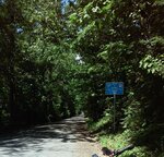
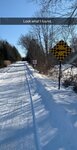
It was going to be all gravel road riding today, skirting the paved roads as much as possible. All in my own neighborhood, the maximum distance from home being about 8 miles at any one time. I actually do have more than 50 miles of gravel roads in a big circle around the epicenter of my farm, but 50 was my goal for today. It seemed doable with the cooler temps presented in the morning. I deliberately didn't check the weather forecast- whatever it said wasn't going to matter. I was going to ride regardless.

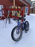
So this was the view I enjoyed for the next 4 hours, from the front, and following behind.

0612201317a_copy_672x840.jpg


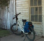
On one of the gravel roads I discovered the ruins of an old stone barn...or maybe it was an old house. Hard to tell. There was a man just out of a stone's throw reach doing something in a weedy patch of ground. He seemed to be studying the ground as he walked slowly along, pausing now and then to bend down to pick something up, look at it intently, then drop it as he continued to walk forward. Figuring he was the owner of the property, and, by rights, the owner of the barn (house?) ruins by virtue of the fact that a gator had been parked and was waiting up near the stone walls, I called out, waved hello, and asked if he would mind me taking a photo of the old building. He waved back and hollered for me to "help myself", then proceeded to continue walking very slowly through the weed patch, still inspecting the ground. I was halfway ready to ask just what he was doing, but figured it best just to pose the LaFree for a photo shoot, and leave it at that.

I still have no clue what he was doing, or looking at (for?) as we exchanged goodbyes and I headed off down the gravel road.

0612201123_copy_878x424.jpg


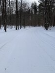
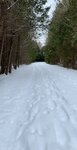
It was a day for views, and at each crest of each gravel road there were ample opportunities to give the phone camera a workout. No permission needed.

0612201318_copy_917x490.jpg

0612201128_copy_896x538.jpg

0612201133_copy_884x546.jpg

0612201249_copy_896x538.jpg


At one point I decided to adjust my route slightly to take a gravel road that (unfortunately) ended on a major 4 lane divided highway with a wide, densely overgrown median strip full of trees, brush, brambles, and other noxious things I'd rather not encounter with traffic speeding past on both sides. I decided if I didn't want to quickly bike the short 1/4 mile on the "wrong side" (my side) of that highway to the next gravel road (also on my side), I could always turn around and go back.

Maybe it was this convention of cheeky gnomes at the end of someone's farm driveway who decided it for me, especially the one hanging in the tree by his britches. They all seemed to say go for it...and so I did. But not before taking their picture in case I wanted to point to someone to blame for what would be a bit of a hair-raising, very fast sprint, riding the wrong way against major traffic, to the next road over.
0612201200_copy_896x538.jpg


Suffice to say, I pushed the LaFree to the max on the paved shoulder of the highway, and probably scared about 20 oncoming motorists to death since I was pretty boldly breaking traffic laws. Next time I do something that foolhardy, I'll go with the flow of traffic. This time it was impossible, however, because there was no crossover from the proper side of traffic and through the overgrown grass and tree median in order to get to the road I wanted. I would have had to have gone over a mile on the main road's shoulder, further past the gravel road, enduring 60-65mph traffic at my shoulder before I finally reached a proper crossover, and then turn back and go 3/4 of a mile back with 60-65 mph traffic coming up behind me, again at my shoulder. Legally I could have walked my bike the 1/4 mile on the shoulder against traffic, but with no law enforcement in sight it was easier to be a scofflaw and ride the bike on the highway shoulder against traffic in a fast, short run for the road I wanted.

It took only a minute or so, and I was then safely back on the gravel roads, this one going through a number of horse farms, one of which had carriage horses. I thought their sign was hilarious.
0612201211a_copy_1040x1406_copy_520x703.jpg


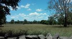
Back on my old familiar network of gravel roads, I took opportunities to enjoy posing the LaFree next to a few picturesque scenes: a tiny, ancient and very tired wooden and concrete abutment bridge stepping over a small energetic brook, an old paint chipped building that used to be a service station and general store more than 60 years ago that still had a boot advertisement glued to one window pane, and an old-public-road-now-private-farm-lane where I could stop and eat a snack under the cool shade of the nearby trees, and within spitting distance of the mountains.

0612201313_copy_1222x2016_copy_488x805.jpg


0612201258_copy_1446x1328_copy_723x664.jpg

0612201250_copy_537x895.jpg


By the time I hit 40 miles the heat was rising, jumping up the thermometer towards 90°F (32°C) much faster than I'd anticipated. I was losing steam, the breezes had become a headwind, the air was now hot rather than cool, and both my knee and my resolve had lost enthusiasm for collecting any more miles. All my effort was, at that point, focused towards the job of moving forward. Thankfully, the LaFree could rocket right along when I asked, especially when we hit those rare instances of paved roads between the gravel ones. I also found I was pretty adept at taking a photo while riding...as long as the going was smooth and traffic was at zero.
0612201456a_copy_478x549.jpg


At 46 miles I was within a mile of home, following my next door neighbor who was hauling hay rolls on a farm wagon. I was aimed at 6 more miles of gravel roads to my left...but the heat had done a number on me, and my knee, after so many miles of rolling roads and a 3,000+ elevation change record, outright lobbied to cease and desist for the day. I capitulated, and decided to head to the right and go the one mile to home.

0612201456_copy_672x439.jpg


There will always be another day to do a 50 mile gravel road ride. I'm sure the gravel roads will wait until then.
 

Attachments

  • 0612201434_copy_672x643.jpg
    0612201434_copy_672x643.jpg
    188.3 KB · Views: 267
  • 0612201318_copy_917x490.jpg
    0612201318_copy_917x490.jpg
    171.2 KB · Views: 273
  • 0612201258_copy_1446x1328_copy_723x664.jpg
    0612201258_copy_1446x1328_copy_723x664.jpg
    132.7 KB · Views: 275
Last edited:
but I challenge anyone to come out to Virginia during June and let's see how they'd fare when the afternoon temps are cresting 86°F (30°C)
I didn't ride out on Friday and (you'll be laughing at me!) I overlooked the fact it was as much as 34 C (93 F) outside. After all that cold Spring! Out of nowhere. Drove to a grocery store and seeing the "34 C" on my car's thermometer I disregarded it, thinking it was the temperature in the sunshine! My mind was not ready to accept the fact such warm weather might exist. I washed my Monster in my yard later, with bare torso.

@David Berry, here you are:

1592024750093.png

I don't know the name of these flowers. I call them "little bells".

1592025061305.png

I cannot photograph red flowers such as poppy. The colour is always wrong in photos.


Talking about photography, I have found the Sony camera very practical, yet it is not perfect for landscapes involving a lot of small detail. Since we're going for a long ride in "Very Central Poland" on Sunday, I might consider taking the full-frame Pentax camera with two fixed focal length lenses (90 and 35 mm ones) in a pannier, and the Sony compact camera on me. We'll see.
 
Last edited:
3 miles doesn't seem like much much to push to obtain 50 miles when you're at 47 miles already, but I challenge anyone to come out to Virginia during June and let's see how they'd fare when the afternoon temps are cresting 86°F (30°C), and any pause with the bike brings copious streams of sweat created just under the helmet to cascade down the face.

The 3 miles to make a 50 even just wasn't in the books today. Too close to home, too hot to go another mile. Maybe next time.
I know what you mean, sometimes you just have nothing left! In October 2018 I set off on a lovely Autumn (Fall) day expecting to cover 100 miles, as I entered my town I only had another 6 miles to go to complete the 100, I only managed 95.7 when I just had nothing left! Nothing to do with the heat that day though!;)Great read once again! :)

1592044445134.png
 
@RabH

That is an awesome achievement, especially the elevation changes over that distance.

I'm convinced those high number elevation changes are what sap the energy right out of you. I think that the 3k+ elevation changes, combined with the heat, is what did me in yesterday. Even with an electric bike, going up hills demands the lion's share of effort...especially hard on anyone looking in the rear view mirror at a half century (or more) of age gone by.

So heat, fatigue from a lot of road climbing, knowing I had animals waiting for me (plus a hubby) at home, and being only 1 mile away from my house with the additional 3 miles needed being in the opposite direction - all those combined to be the catalyst for me to cut short the ride.
Yes I agree, elevation changes make quite a difference and eat up battery also!
 

Attachments

  • elevation_profile157.jpg
    elevation_profile157.jpg
    23.7 KB · Views: 284
That photo is astonishingly beautiful. The Moon!
Check the direction that the shadow falls from my ebike to find the location of the sun; then, for the same purpose, look up to the moon's shadowline.

That photo was taken two days ago, so when I go out tomorrow (Monday) the moon will be 'larger' but higher. Today is forecast to be wet (good; it's not an ebiking day!) but hopefully there'll be dramatic skies and a clear view to a distant horizon tomorrow.

Fortunately, the power lines were lit by the sun and are scarcely noticeable! I had to back off some distance and then crop the image severely in order to lose those wretched lines between the rising river mist and the clear sky. Had there been a clear sky, the image would have been less attractive. Power lines, fences and unkempt grass next to a road: Ugh!

The photo at the top of the page was taken not far away but almost two hours later. My route was, indeed, circuitous and punctuated by a leisurely lakeside break!

For those who are interested in such things, the GPS location of images is embedded in the file data and the date and time are shown in the file name (YYYY-MM-DD-HHMMSS).

As always, click/tap anyone's photo or map to fill the screen. Hovering the cursor over an image will reveal its filename.

Now it's time for me to have a rather late, but leisurely, Sunday breakfast. A bowl of steel-cut oats with maple syrup for starters, then…

2020-06-12-map-a.jpg


Twin Bridges : river photos (more to follow)
X : country road photo
Cormorant Bay : Lake Wivenhoe photo
 
Last edited by a moderator:
First day here, excited to meet everyone and loving the threads and photos.

Wanted to share a few photos from my first winter of properly riding the white fluffy stuff. These photos are to remind us to enjoy every beautiful sunny day (those of us who are in our summer months of course, lol) and make the most of our time out riding before old man winter comes rolling in once more.

Cheers
 

Attachments

  • 2020-02-08 12.27.25.jpg
    2020-02-08 12.27.25.jpg
    333.1 KB · Views: 312
  • 2020-02-08 16.12.47.jpg
    2020-02-08 16.12.47.jpg
    332.9 KB · Views: 285
  • 2020-02-14 14.45.23.jpg
    2020-02-14 14.45.23.jpg
    337.5 KB · Views: 303
  • 2020-02-14 14.55.03.jpg
    2020-02-14 14.55.03.jpg
    382.2 KB · Views: 312
  • 2020-02-16 13.39.15.jpg
    2020-02-16 13.39.15.jpg
    236 KB · Views: 281
Back in the saddle today on a lovely day for cycling, 14C and very little wind! It seems like many people are now back at work as I only encountered about 3 cyclists during my 32 mile trip! Just a local route once again with lots of twisty roads, it was just so much fun in these dire times! Not so many photos today as it wasn't the most scenic route, even the horses were absent today! :p It was good to see the golfers back out enjoying themselves on a perfect windless day, its now looking like we might have more restrictions lifted in 10 days, so a possible return to work!

View attachment 54803
Am I reading that right? max speed 42.8mph?! :eek:
 
Well I was going to do a video on the confederacy links to my city in England.....and I think I'll give it a big miss atm.
I can just see me cycling up to the cemetery in the very borough that had britains worst race riots in the city that was basically ground zero for the slave trade and asking where the grave is of the head of the confederate navy.


Maybe when things have cooled down,.and if its still there :)
 
Memories …
2020-06-12-092131-2400-gb10.jpg

Brisbane River at Twin Bridges
An ancient motorhome overnighting next to the river. This is what memories are made of!

In the early seventies when Jen and I were first in Australia we toured the country, 'wild camping' at spots like this. Our VW Kombi, which had made the journey with us aboard the migrant ship Oronsay, parted company in New Zealand where, just perhaps, it is parked next to the Waikato or other idyllic river at this very moment.
 
Last edited by a moderator:
A Fast Ride On A Fast Bike

I'm going to let the stats speak for themselves. I stopped only twice for two photographs because I couldn't resist.

Otherwise, the Vado and I stayed in low altitude flight, flying under the radar just as fast as we could.

Screenshot_20200613_205536.jpg


0613201439_copy_537x895.jpg


0613201440_copy_537x322.jpg
 
max speed 42.8mph?
Downhill, downwind, right @RabH? ;)

I need to tell you a story! When riding my Speed Vado street-legally (that is, where a Class 1 e-bike is not allowed but the Class 3 one is), I'm often getting a driver honking at me because they don't understand they see a moped, not a bicycle. I've found what I should do:
  • If the car drives in the same direction I ride, sound the horn thrice.
  • If the car comes from the opposite direction, light the high beam headlight. The 1700 lm should wake the driver up :D
It is not I bought my Vado's registration plate on a bazaar... 🙃
 
Last edited:
Back