2020 : Our Rides in Words, Photos & Videos

  • Thread starter Deleted member 18083
  • Start date
Brisbane's south-western suburbs …
My knowledge of architecture is close to non-existent so these homes will simply have to be presented as representative of the surviving gracious homes from a century of more ago. My main criterion for choosing these three was the absence of high fences, sagging powerlines and the like!

The avenue in the Sherwood Arboretum was planted in 1925 which, I'll guess, was before the third house was built but a few decades after the two 'Queenslanders' were set upon their high stumps.

2020-05-06-095909-ebr.jpg

Hazelmere Parade, Sherwood

2020-05-06-100929.jpg

Laurel Avenue, Chelmer

2020-05-06-100502-ebr.jpg

Laurel Avenue, Chelmer

2020-05-06-094842-ebr.jpg

Sherwood Arboretum

Photos have GPS coordinates embedded in them so opening in an app like Apple Photos will reveal their exact location.
 
Last edited by a moderator:
Wow. I saw two other e-bikers on the road today. One this morning on a Rad Rover. I've seen him before. Then, whilst I was riding up the first hill, a guy on another Rad Roverish looking bike was catching up to me. He was just using the throttle. He turned off before passing me.

I ended up riding part of a road that I had not been on. Ever. It was nice although a bit more civilized than I like. I came across this in the front yard of a kind of unfriendly person. He yelled at me "What are you taking a picture of?" I should have yelled back Neinen sprckinzy Englitch cuz I was on a bicycle (as you can tell, I don't speak German either) . It was kind of like the old bar standby of WHAT ARE YOU LOOKIN' AT. I yelled Boat, Legs and had to repeat BOAT LEGS Then got an OK but I had already snapped the picture so it didn't matter. Here is BOAT LEGS.

DSC01129.JPG


I rode on up the road. It was a nice riding road. I stopped to take a picture of a Not A Rattlesnake but it slithered quickly out of sight. So, here's my bike on the nice road. Not a good day for taking pictures, I guess.
DSC01130.JPG


This road connects with the Dry Coulee Road, which is the road I had to turn back on last time because the county road people were dumping sand on it. Today I was able to ride on it and it was pretty nice. It had more traffic on it than in the past when I've been on it and pot holes were already making an appearance in a few places. But off to the side, it was smooth. It was not dusty because we had a good rain yesterday.
DSC01131.JPG

As I dropped back down into the valley, I saw the fresh snow in the hills that occurred yesterday. This is looking east across the Okanogan Valley.
DSC01133.JPG

This was a 20 mile trip and I haven't ridden very much lately so it was hard on the buns. The buns need to get used to what was a very comfy seat last fall. I'm sure it will be again.
 
A ride through the cabbage patch …
2020-05-01-pat-est-ebr.jpg

Lockyer Creek irrigation area, Patrick Estate, QLD
One thousand posts since the beginning of 2020. We must be having fun on our ebikes!
 
Last edited by a moderator:
Rewards, smelling the roses, and a big ol' mountain

I was very happy with myself today. After working like a slave all morning long on every farm chore that needed to be done, and finishing up the garden fence and laying the first of the slate walkway, I was going to reward myself by giving myself the afternoon off to do whatever I wanted. Anything I wanted. Despite a tired body and a real argument over a nap vs. a ride, the ride won by a whisker and a promise to be short so that the nap could be squeezed in.

(Yeah, right)

My friend 100 miles south of me had been out riding in the morning, and texted me that it had been both windy and cold. It was the same up here, 100 miles north, but there was a promise of warmth and calm for the afternoon, which I took literally. Literally enough to dress for winter biking, but hoping for summer biking.

Good thing I did dress warm because right out of the driveway the cold winds got right into my face and did not let up for the first 10 miles. It wasn't until 15 miles that the winds died down, the temperature shot up like a rocket, and I could shed the extra jacket and the windbreaker overpants and enjoy the first 70 degrees (F) in several weeks.

Stats:

Map-5-7-2020-new.jpg


The ride started off slowly (tired body) but I wasn't in a hurry. I planned about 7 miles, just a short out and back. Nothing strenuous, nothing long. I had that nap waiting...see?

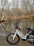
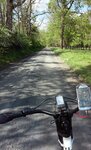
So it was a ride to smell the flowers, listen to the birds, and see what Mother Nature had popping up in her wild gardens. Which meant a ride on the gravel roads, which meant the LaFree and I would be partners today.

The phlox (see below) and the fleabane are in full bloom already - both field flowers that bloom in early summer.
5072020-1425-40perc.jpg


The long peaceful gravel roads kept me protected from the wind and the sun. Surprisingly, it was quite warm where the winds were not allowed to blow me about, and I almost surrendered my jacket several times. Discretion prevailed, however, as soon as I was out in the wind again the cold reasserted itself with a vengance.

5072020-1539-45perc.jpg


My ride took me north to Bluemont where, for some strange reason I looked up at the mountains and completely lost all my marbles (sense of reason) deciding, on a harebrained whim, to ride up the slope of the mountain to see what the view was like at Dirt Farm Brewery. Yes, I had completely lost my mind. Allow me to show you what the elevation was and the slope gradiant:
Map-5-7-2020-Grade.jpg


Elevation 1,059'. Valley floor: 591'. Maximum Grade: 22.9%. Distance: 1 Mile. Probability of Killing Myself riding up to the top: 100%

Here is where I started: Doesn't look so bad, does it? Guess again.
5072020-1452a-45perc.jpg


Here is the view halfway up: I was already in the lowest gear, gasping for breath, and my legs already questioning my sanity and debating whether to give it up at that point. I figured the sign was encouragement. (Actually, the sign was lying, but I didn't know that until later)
5072020-1433-45perc.jpg


And here is the view from the top. I will never, ever, EVER, do that again! I was in Granny gear (1), top assist, and wishing I had a Great Great Great Granny Gear climbing up that road. I could barely breathe for gasping for air, my legs were about to mutiny, and I could hear the motor saying "We can do it We can do it We can do it" while I chanted to myself "Don't look up Don't look up Don't look up". I honestly, at one point didn't think I would make it because the slope was so steep. To take this photo I had to hold onto my bike because it was not going to stay upright on that extreme slope with the kickstand.
5072020-DirtFarmBrewery-overlook.jpg


So I arrive at the top, still gasping for air, my lungs on fire, legs shaking, just ready to throw myself down and die for at least a few minutes, when out of the brewery comes a very nice young lady, heading toward an outbuilding with a tag along cart. I can't even catch my breath to say hello, so I simply watched her as she loaded the cart with some brew, and turned to go back into the building. She caught sight of me then and called out a hello. At that point I was less on the verge of collapse, was gasping only moderately, and could answer back. She asked if I needed any water, and I raised my bottle aloft to show her I was good. I explained I had just come up to take photos, and she told me that a lot of cyclists love to come up the mountain, and some even have contests to see how many times they could ride up the driveway/road. One guy apparently did it 20 times in a row.

My jaw dropped. "Are you serious?" I asked. She said "Yes" with a smile. "Honey," I said, "that was not a cyclist. That was a machocist with a side order of sadism." She laughed and checked again that I didn't need anything to drink. I told her I was good and thanked her again. She headed back into the brewery as we waved goodbye to each other, and I commenced to walk...not ride, WALK... my bike back down that road, both brakes on hard. There was no way on this green earth that I would have climbed on that bike for a ride down. You couldn't pay me enough to put my foot on the pedals. I would have broken every land speed record ever recorded and overshot the turns like an out of control toboggan on Mt. Everest. Nope. I walked down, leaning back against the pull of gravity, while my LaFree was kept on a tight rein. I had to turn the LaFree around and face uphill to take the photo below, otherwise the bike would have taken off like a shot and raced down the hill all on its own.
5072020-1433a-45perc.jpg


So much for a relaxed, smell-the-roses ride. Finally at the bottom my legs were still in shock, my lungs not quite recovered, and here was this nice winery next door just begging to be visited. Yeah.... that's a big NOPE. I'll come back in my car to take photos. No more mountain climbing for me today.

5072020-1455-45perc.jpg


My sanity restored, I decided it was time to get back to relaxing, and so headed south towards Upperville. There is a delightful old gravel road that takes you straight to the east end of Upperville, and enroute just oozes charm and tranquility. It was the perfect road to center myself and restore some peace and calm. It was also getting warm enough to shed the jacket and over-pants, and enjoy some sunshine as well. I did meet a husband and wife riding a Cannondale tandem at the top of this road, so we stopped to chat for a moment. They had started out in Middleburg and had already finished about 20 miles and were heading back to finish up at 40 miles. Both looked like they were having a blast, and I complimented them on riding up the gravel road, rather than down. (Yes, it makes a big difference as there is a steep incline coming the opposite way). They were impressed with my electric bike, and after a few more exchanges of pleasantries, we waved goodbye and headed different directions - them back to Middleburg, and me towards Upperville.

At the bottom of the old road is a bridge built in 1916 by a bridge building company in York, PA - or so the historical plaque claimed. All the creeks in the area were running fast due to yesterday's rain, but none at flood stage, thankfully,
5072020-1546-45perc.jpg


A mile later:
5072020-1555-50perc.jpg


Now, the funny thing about the "Please Drive Slowly" is that it is a bit of a hidden joke. You see, way, way, way, WAY back in the past, when stagecoaches ran the roads from Alexandria and Washington DC, through Middleburg (hence the name as it was a midway overnight stop) and then west the remaining miles to Winchester (which was, at one point, the farthest west you could go before you hit the Native American territory), all the coaches had to go through Upperville. Way back then, Upperville had a bad reputation and was home to quite a few highwaymen, thieves, miscreants, and neerdowells, so the stagecoach drivers were told to whip up the horses and gallop through town and not to stop for anything otherwise they'd be robbed blind of not only their money but also of the stagecoach horses!

Kind of funny that the once badboy town now asks people to drive slowly, don't you think?

It is a pretty town with lovely historic homes that have been beautifully restored. And quite the pleasant ride now that the highway men and the criminals are all just history book characters.

Turning north towards home out of Upperville, the Blue Ridge is so close you could almost reach out your hand and touch it.

5072020-1610-50perc.jpg


The remaining 9 miles were so quiet, so serene, so temping to just keep going on. But my nap awaited, and so the LaFree and I made a beeline home at a relaxed pace. Rest assured we will get out together another day to enjoy these roads once again.

5072020-1628-40perc.jpg
 

Attachments

  • 5072020-1628-40perc.jpg
    5072020-1628-40perc.jpg
    148.3 KB · Views: 315
Last edited:
For some strange reason I looked up at the mountains and completely lost all my marbles (sense of reason) deciding, on a harebrained whim, to ride up the slope of the mountain to see what the view was like…
Brilliant story, as usual!

Wimp's ride …
I was unadventurous, cowardly even, and kept to the flatlands (in the absence of hilltop micro breweries and boutique wineries to tempt me skyward)…
2020-05-08-103728-ebr.jpg

Coominya, Queensland
 
Last edited by a moderator:
I was out yesterday as well. The weather was just too lovely to pass up, despite some winds. Fortunately, riding from Leesburg, I was mostly uphill and into the wind to start the ride, and finished with a bit of a tailwind. Always nice when the wind doesn't pull its "you get a headwind both ways!" thing.

First up, map:
DanqeQuh.jpg


Think I overlapped you, readytoride, a few places. We will run into each other one of these days.

Ride started with a long run west on the W&OD. I've been avoiding it for a while now because even with the social distancing guidelines, it tends to be pretty busy on nice days. But heading out at 3 on a weekday I figured it was probably ok, and it was mostly empty.
VGroyi9h.jpg


I usually take a different route west, but I had 3 hours to ride and wanted to get into some of the lovely gravel around Bluemont, and that meant starting the ride with 8 miles of boring, boring pavement.

Finally got onto unpaved roads around Lincoln:
2eqeHWwh.jpg


The locals are pretty bike friendly. Someone followed me in a truck for a bit on this run and when they finally passed they called out the window to congratulate me on holding 20mph up the hill. I was too out of breathe to let them know I had some electric pixie help.

Cockpit view:
J2aI9Agh.jpg


Quick water break and wanted to adjust the rear derailleur a click. McMansions going up in the distance. This part of Loudoun is fighting to retain its rural character, but IMO its slowly, slowly losing that battle. Which is probably the best it can hope for. Also, realized on this ride that my right shifter got bunged outward slightly and I need to fix it. Which this pic shows very clearly. My bikes live in my woodshop, and sometimes things get pushed out of wack being moved around.

Heading west:
1nM5IRnh.jpg


Just a spectacular day. Aim is to get to the gravel at the foot of the mountain in the distance before turning around. Mt Weather is on the ridge (sooper secret government center). I've done road rides that go along the ridge before, and if you stop near the gate, men with guns come out to give you a look and ask you to keep moving. Don't stop between the fences.

Hmmm.
Nr1fGA6h.jpg


I ignored the sign and rode down. Fortunately the worst was a some rutting and about 12" of water over the road at the low point. The heavy rains do hit some of these little roads hard. I rode right through no problem, but it did put a nugget of concern in my mind because I was planning on running back to Philmont via Jeb Stuart road, which has a good sized stream crossing to deal with. With all the rutting and running water I was seeing, I started to wonder if it would be crossable.

Bike glamor shot:
nRYmxANh.jpg


Love this bike. Love this view. Not sure about the horses. They always look like they're up to something.

Quick snack stop:
i6EYoZVh.jpg


About as close as I'm getting to Mount Weather. About to turn back east and start working my way back to Leesburg. I also spent a few minutes looking at my phone trying to decide whether to risk Jeb Stuart or do a different route back. Ultimately elected to chance it, and if it was impassable I'd turn around and run into Philomont on St Louis road before rejoining my planned route.

zlFj9tYh.jpg


Sound advice. Lots of old stone walls in Loudoun. Ran into two people on horseback right near here. I always come to a stop for horses, just in case they aren't sure about me and my bike. These particular ones had definitely been there, done that, got the tshirt, and didn't give a poo about me and my bike.

Riding selfie.
8eIhonLh.jpg


Bike control practice! Pro-tip: wait for a portion that isn't too rutted before playing with the camera while riding.

On Jeb Stuart:
H3hFawjh.jpg


The crossing was high, but passable. I usually take my shoes and socks off and shoulder the bike across before putting myself together and continuing. Two local girls were having a picnic on the bank and let me know that someone had just come through and carried his bike across. Turned out to be a friend of mine out hunting for strava KOMs. He was about a minute ahead of me and rode the same route for the next several miles, but I never caught him. Fast mofo.

Philomont general store:
gqFddGDh.jpg


Best resupply point! Didn't get anything today, but I usually plan my rides so I can swing through and get a snack. Really cool historic general store that is popular with the locals and cyclists. Lots of moto groups seem to plan rides here as well; I've chatted with a lot of them while munching on snacks on the porch on previous rides.

My indecisiveness meant I was running slightly behind, so the camera stayed stowed for the remainder of the ride. Great day to be out!
 
My ride took me north to Bluemont where, for some strange reason I looked up at the mountains and completely lost all my marbles (sense of reason) deciding, on a harebrained whim, to ride up the slope of the mountain to see what the view was like at Dirt Farm Brewery. Yes, I had completely lost my mind.

That view is spectacular, and next time I'm out that way I'm definitely heading up to get a pic. :)
 
Ladies and Gentlemen... er... friends!

I missed so many of your brilliant stories, excellent photos and interesting maps. Applause to @Readytoride for her mountain exploit! (an e-MTB next?) ;) David looks to be in perfect shape. I'd like to commend all of you in this thread (RabH, Alaskan, Mr. Coffee, ElRojo, etc) since being bikeless at the moment means I can at least enjoy your adventures as if they were mine. Thank you!
 
@jabberwocky - Looks like we did miss crossing paths. Glad you had a great ride and maybe next time we'll bump into one another! Will look for you!

Adding to Jabberwocky post - a picture (below - taken in January) of the Jeb Stuart road creek crossing when it was running at normal height. There is a small (man made?) rock causeway slightly upstream (beyond this photo to the right) that is only ankle high vs. the calf/knee-high depth of the crossing itself (if you don't accidentally step into a deep hole just to the left and go waist high in the water). I walk my bike across next to the rocks off camera to the right where the shallows are - no need to portage. But you do have to thread your way back to the road along the creek side of the bank which is too high and too steep to lift a bike onto.

JebStuartCreekCrossing-small-cropped.jpg


Trivia Note: J.E.B. (James Ewell Brown) "Jeb" Stuart was a general and cavalry commander (Virginia 1st Cavalry) during the American Civil War (1861-1865). He graduated from West Point military academy in 1854, and served in Texas and Kansas with the U.S. Army until the South seceded from the US in 1861. He immediately resigned his US commission and joined the Confederate States Army. His command stretched throughout the war and he was considered one of the most colorful generals of the South. On May 12th, 1864 - exactly 156 years minus 5 days to the date @jabberwocky crossed the Jeb Stuart creek - a dismounted Union trooper fatally wounded Gen. Stuart at the Battle of Yellow Tavern, just six miles north of Richmond, Virginia. Stuart died the next day at age 31. His widow, Flora (nee Cooke), wore black for the rest of her life in remembrance of her deceased husband. (Check out his history on Wikipedia - his lineage, as well as the lineage of his wife, is interesting)
 

Attachments

  • JebStuartCreekCrossing-small.jpg
    JebStuartCreekCrossing-small.jpg
    251.5 KB · Views: 296
Last edited:
Wear an oxygen mask, and drink a Red Bull before you start that climb up the driveway. 😛 Or, better yet - go to the top of Bluemont Vineyards. And then tell us all about it. We'll be down below waiting with bated breath. 😊

Hah! Back in my more hardcore roadie days, I did the climb from Bluemont up to the top of Mount Weather several times. Its a bitch of a climb, gaining 900ft in about 2.5 miles. Dirt Farm is about half that in height but does it in 1/5 the distance, so it definitely looks steeper (which is saying something, because the Mount Weather climb is far from gradual). The grades are impressive, especially towards the top; Ridewithgps is saying it holds 18-20% for a bit :oops:. It will be a good test of the bike, assuming I survive. As Calvins dad always said, suffering builds character. I'll post a pic and let you know how many times I threw up.

Adding to Jabberwocky post - a picture (below) of the Jeb Stuart road creek crossing when it was running at normal height. There is a small (man made?) rock causeway slightly upstream (beyond this photo to the right) that is only ankle high vs. the calf/knee-high depth of the crossing itself (if you don't accidentally step into a deep hole just to the left and go waist high in the water). I walk my bike across next to the rocks off camera to the right where the shallows are - no need to portage. But you do have to thread your way back to the road along the creek side of the bank which is too high and too steep to lift a bike onto.

Yeah, I usually veer right where its shallower, go across, and hug the far bank back to the road on the other side. Its actually perfectly ridable most of the time, as long as you don't expect your bottom bracket to last forever. I normally ride it on my normal bike but don't want to submerge the motor on the ebike so I ditch my shoes and socks and walk it across.

Yesterday it was running a bit deeper than usual. Even taking the shallow line across, the bottom part of my shorts got wet. Had to shoulder the bike through the deep part to keep the motor dry.
 
Back