2020 : Our Rides in Words, Photos & Videos

  • Thread starter Deleted member 18083
  • Start date
You can ride some of the Chuckanut Drive on trails and alleyways. Years ago I ran the Fairhaven to Larrabee State Park foot race, along pathways that followed the road.

I also drove that road, which as JRA alluded to is very narrow in parts, in my V8 Powered Mazda Miata, at a slightly faster pace. :p

We moved to Vancouver Island 5 years ago and I miss my frequent drives down to Bellingham/Fairhaven and lunches at LaConner.
It's all about time of day. 9-11 and 1-3 are low traffic, good bike times. It's an epic road and fun to ride.
 
como along willamette.jpg
 
Sunrise over Moreton Bay …
2020-05-04-moreton-bay-ebr.jpg

Looking east from Brighton Beach, Brisbane
On the horizon…
  • Left: Woody Point, Redcliffe Peninsula – apartments & fishing/strolling pier.
  • Right: Port of Brisbane – container terminal cranes.
2020-05-04-moreton-bay-map.jpg
 
Escaping the To-Do List

It was a long list. [It always is] It was also supposed to rain. [But it didn't] And who wants to be stuck indoors yet again for another rainy day? [Not me]. And we are supposed to have an overnight frost [so they say] so bad time to plant the veggies in the new garden just yet [I agree]. Mowing the lower field needed to be done [but...isn't the ground still too wet? Yes, yes it is...] and weedwacking the back field fence line [not my job, sorry], and cleaning the house [don't remind me], and vacuuming out the car [later, I promise]. And ride your bike.

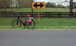
Well, that was one item I could check off the list...

But...isn't it supposed to rain?

[Studies the clouds overhead] Well, how about I just strap my rain jacket to the top of the back rack and cross my fingers? And I'll stay on the paved roads this time. Maybe head south into Fauquier? Roads should be quiet this time of day. Just a short amble, a nice loop down then home? Plenty of time in the afternoon to catch up with other "stuff". How does that sound?

Huh. Sounds good to me. Go have fun, and take pics. The list can wait.

[It always does]


Map-5-5-2020.jpg


0505201109a_copy_896x1493.jpg

My chosen route was almost all paved road (because the gravel roads were still wet from the rains and my Vado is only supposed to be for paved road riding). I had to traverse 5 miles of gravel roads to avoid 3 miles of (in my mind) rather dangerous high speed paved road in my neck of the woods to get to Rt. 50. Once on the quieter, less hairy paved section I headed due south, across a main E-W highway (Rt. 50) onto Atoka Road a state designated scenic highway in Fauquier County.

0505201110_copy_896x1493.jpg

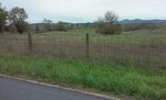
We are in the eastern border of Piedmont Foxhounds hunt country, close to the northwestern border of Orange County Hunt territory. Now, just a bit of Virginia hunt history - back in the 1890s through the 1920s there was a flow of northern foxhunting folk from Orange County, New York who found the southern winter climate of Virginia to be just perfect for hunting through the season. They brought their hounds (American - red and white), their hunt buttons (not hunt "colors" for the hunt coat collars which is usual for most hunts), and their original hunt's county name, established this Virginia hunt in 1900 and were recognized in 1902 with territory in northern Fauquier County just below Middleburg. As a result, thousands and thousands of pristine acres of farmland have been preserved, and the beautiful vistas are still as they were for centuries (with the exception of the main roads being paved, not gravel). Atoka Road is close to the borders of these two hunts, so biking down the road gave me views of both territories.

0505201120_copy_896x1493.jpg

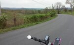
Surprisingly, for a main North/South highway, Atoka Road was extremely quiet. I could count on three fingers the number of cars that passed me on my side during those tranquil miles. A few more in the opposite side, everyone polite, waving hello. I really, really enjoyed the ride.

0505201120b_copy_896x1493.jpg

The varied walls of Virginia Hunt Country. Mostly stone walls and board fencing, some quite decorative while still being functional. The decorative fencing was usually reserved for thoroughbred horses in residence. The more utilitarian board fences were reserved for cattle and hay fields. Saw a lot of farm tractors out, mowing fields. They had no problem checking off their To-Do Lists. All of them smiled and waved hello as I passed. Bet they were wishing they were out riding a bike rather than a tractor!

0505201137_copy_896x538.jpg

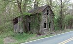
Rectortown, the bottom of my loop. Sign is a bit small in this pic, it says the town was established in 1772. In 2004 it was placed on the National Register of Historic Places. Very quiet, very historic little enclave. Not much of a town anymore. Just a few old houses beautifully renovated.

0505201135_copy_896x538.jpg

The open countryside bounding Rectortown Rd. These were my views as I head back on the return leg of the loop.

0505201142b_copy_896x538.jpg

Yes, that is rain. No, it wasn't hitting the ground. Yes, it is called "virga".
No, I didn't get wet. Yes, that made me happy. No, I didn't linger to take more pictures of it. Yes, I was actually worried it would change to "real rain". No, it didn't, thankfully.

0505201135a_copy_896x538.jpg

The views of southern Piedmont Foxhounds territory heading back towards Loudoun County.

0505201208_copy_896x538.jpg

A stone wall just outside of Upperville at the very border between Loudoun and Fauquier Counties. There were several of these "holes" in the long stone wall that bordered the main highway. Can you guess their purpose? (Hint: it does have to do with foxhunting)

[Answer: it was a built in gap for the hounds to get through when hunting so they weren't forced to climb/leap the stone wall. This wall predates the paving of the main road through Upperville back in the early 1900s, and the increase in both traffic and speed. Nowadays, a hunt Whip (staff member) would be stationed on or near the road to stop all traffic if the hounds were running in a direction that would cross the road through these gaps.]

A lovely (almost) 30 mile cruise through a county known for its beauty and landscape. Luckily missing the rain. Not missing the To-Do List whatsoever.

(Yes, I did get one other thing on that List done - mowing the lower field just before it actually did begin to truly rain. No, no simply virga. Yes, real rain drops. No, it hasn't stopped raining since. Yes, it rained all night long. No, I'm not pleased because it means the To-Do List is being set back another day. Yes, I am considering the fact that I will soon have lakefront property. No, I won't buying a boat...at least not yet. Yes, I will try to sneak out for another ride today...if it will stop raining. No, I don't have a lot of faith that it will stop. Yes, tomorrow will be a better day to ride, especially as I have plans to ride with my neighbor, fingers crossed. No, I'm not going to look at the To-Do List again. Yes, I'll get to it later...maybe.)
 

Attachments

  • 0505201128_copy_896x538.jpg
    0505201128_copy_896x538.jpg
    213.6 KB · Views: 362
  • 0505201131_copy_896x538.jpg
    0505201131_copy_896x538.jpg
    167.1 KB · Views: 363
  • 0505201142_copy_896x538.jpg
    0505201142_copy_896x538.jpg
    114.3 KB · Views: 365
  • 0505201135b_copy_896x538.jpg
    0505201135b_copy_896x538.jpg
    139.5 KB · Views: 363
Last edited:
Follow this cycle path on Google Street View …
2020-05-06-123245-ebr.jpg

Left bank of Brisbane River, facing upstream (SSW).
  • Start with this link – Google Street View.
  • Click your way along the Brisbane Riverside pedestrian and cycle route.
  • Also swing Street View to your left (anticlockwise) to view Story Bridge.
2020-05-06-aerial-numbered.jpg

In the aerial photo the Brisbane River flows from west to east. My ride, from the western suburbs followed the right (south) bank of the river to the Story Bridge where I crossed over to the left bank for coffee with new friends whom I had met on the ride.

The return trip was along the left (north) bank with the photo taken at the X.

Yesterday was a perfect day for riding…
2020-05-06-weather.jpg

"Now" was actually the time the photo was taken. (If you hover the cursor over the photo, the date and exact time of the photo are revealed in its file name.)

Trivia: How many bicycles are in my photo?
 
Last edited by a moderator:
China Camp State Park, CA USA
El Rojo …
Magnificent photo! I've just spent some time browsing through your Instagram portfolio: Wow!

Somehow, I had missed your intro post. Stefan is our resident photography/Vado fan and, I trust, will share his solution to taking photo equipment along with him. I use a fixed-lens compact camera that fits easily into a handlebar bag so cannot offer advice.
… David
Thank you! I have settled on the EVOC 22L Photop backpack.
 
Last edited:
@ElRojo I admit I have had one too many with my online friends yet I will try to answer. I use the Pentax K-1 DSLR and indeed I have got the 70-200/2.8 in my arsenal.
When I am focused on photography during my rides (that doesn't happen often), I carry a 35 mm/1.4, a 50/1.4 or a 90 mm/2.4 and sometimes a 15 mm/2.4 or a 135 mm/2.5 in my Ortlieb E-Mate pannier, which is ideal for storing 3 smaller lens and a heavy FF camera. In case I want to carry the full-size tripod, I keep it in the second Ortlieb Bike-Packer Classic Pannier with Ortlieb Commuter Inserts.

The 70-200 mm/2.8 is just too big and too heavy. If I ever carried that, it would be the Ortlieb Back Roller Plus with the Ortlieb Camera Ultimate Insert.

Hope that helps.

P.S. I'm bikeless at the moment (both e-bikes of mine are serviced). This is my garden that I keep wild and it is raining (Central Poland). The photo was taken with my worst lens (old Sigma 24 mm/2.8). There is a yew-tree at the left (the feeder for red squirrels in the winter time) and two apple trees. The black barrel is for wild birds to have drinking water.
1588814080593.png
 
Last edited:
@ElRojo I admit I have had one too many with my online friends yet I will try to answer. I use the Pentax K-1 DSLR and indeed I have got the 70-200/2.8 in my arsenal.
When I am focused on photography during my rides (that doesn't happen often), I carry a 35 mm/1.4, a 50/1.4 and sometimes a 15 mm/2.4 or a 135 mm/2.5 in my Ortlieb E-Mate pannier, which is ideal for storing 3 smaller lens and a heavy FF camera. In case I want to carry the full-size tripod, I keep it in the second Ortlieb Bike-Packer Classic Pannier with Ortlieb Commuter Inserts.

The 70-200 mm/2.8 is just too big and too heavy. If I ever carried that, it would be the Ortlieb Back Roller Plus with the Ortlieb Camera Ultimate Insert.

Hope that helps.
Thank you very much! I will take a look at the Ortlieb Camera Ultimate Insert.
Cheers! :)
 
Back