Free app provides safer micro-mobility specific GPS navigation for e-bikes

FlatSix911

Well-Known Member
Region
USA
City
Silicon Valley
Just posted on Electrek... this App should help make navigation easier and safer for Scooters and EBikes.


ScootRoute aims to make micromobility safer

As someone who travels almost entirely by two-wheeled electric vehicles, I’ve found that major GPS navigation apps can sometimes be just as precarious as they are helpful. Usually intended for cars, most GPS navigation apps can occasionally send us micromobility users onto unfriendly streets. But now ScootRoute is solving that problem with a highly customizable navigation app designed specifically to help riders of e-bikes, e-scooters, and other micromobility devices stick to safer roads.

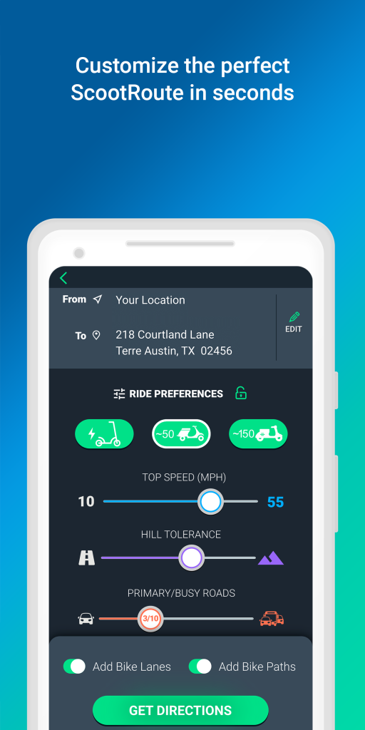
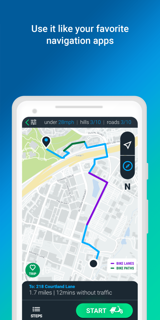
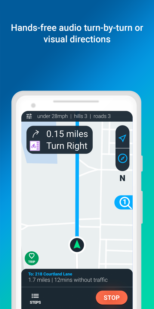
ScootRoute works in cities and suburbs, letting riders select specific perimeters to receive customized turn-by-turn GPS directions. Factors such as hill-climbing tolerance, traffic, bike lane availability, road type, and speed limits can be adjusted by the user, according to their preferences. An electric mountain bike rider might want to include the option for shortcuts across off-road trails,
while a scooter rider will likely prefer sticking to streets with bike lanes or low speed limits. The app also uses three different mapping technologies and includes voice-based turn-by-turn navigation so riders don’t have to look down at their phone while navigating. Commonly used routes can also be saved to access quickly in the future.


Screen-2.png
Screen-4.png
Screen-5.png


ScootRoute is the brainchild of Meghan Braley, a Vespa rider who wanted to find a better way to help smaller vehicles navigate cities and suburbs more safely. She was so passionate about the idea that she left her job at a Fortune 500 company in order to pursue her goal of developing the app.

Being a Vespa rider for more than 10 years, commuting with endless traffic, sporadic bike lanes and confusing signals is frustrating. Popular navigation apps would route me on to highways and off-road bike trails, and I couldn’t find the best and safest streets to get to my destination. Fully committing to the launch of ScootRoute, I left my senior-level position at a fintech company, partnered with a local development shop focused on startups and created ScootRoute™, a navigation app designed exclusively for the growing micro-mobility market.

ScootRoute is available as a free download for both Android and Apple iOS devices.
 
Last edited:
Very interesting. I downloaded and it could be helpful in some scenarios. It is scooter centric, not for bikes as it has public road priority.

I’ll have a chance to test it this weekend, weather permitting. I’m meeting some folks off trail and need turn by turn to the meeting place as I’ve never been there.
 
Very interesting. I downloaded and it could be helpful in some scenarios. It is scooter centric, not for bikes as it has public road priority.

I’ll have a chance to test it this weekend, weather permitting. I’m meeting some folks off-trail and need turn by turn to the meeting place as I’ve never been there.

Great, let us know how it goes with the turn-by-turn navigation function on your EBike.

I like that you can set your ride preferences for Speed, Hill Tolerance, Busy Roads, Bike Lanes, and Bike Paths.

1597873898251.png
1597873885702.png
 
Last edited:
FWIW, bike paths are not a preference, they’re an optional additional route choice. The test I’ll be doing is a group ride exclusively on a MUP. The only public road portion is from the group gathering point in a parking lot to the MUP. I live near the trail and ride turn around so will ride the MUP down to the starting point. I’ll be testing the turn by turn from the MUP.

When I asked ScoutRoute for a route to that starting point all but a mile was on public roads. So the setting recognizes cycling trails but does not prioritize them. That doesn’t mean it won’t be useful in this instance or for rides for which there are not controlled trails.
 
Got it... I try to avoid riding MUPs like the plague. Too many pedestrians with COVID. ;)
Hadn’t thought of that. Most of the folks I see on my morning rides are working out, so I’m not too concerned. I am starting to be more masked than I had been. I’ve been wearing a buff, doubling the layers when stopped. I still do, but now have my regular mask when I stop and go into a store or whatever.
 
Is there an option to turn on satellite image? I've always preferred having that on when using maps.
 
Multi use path....share trail with horses , joggers, walkers , bikers....any of the above....not a single track for bikes
 
I used ScoutGuide for turn-by-turn guidance to get to the off trail starting point for a group ride, Saturday. The directions to the start the group provided were for cars on streets. I was taking the MUP.

Most of ScoutGuide’s directions were for street’s but the last mile was on the trail to the meeting spot parking lot. Those were perfect.

I almost ride on the MUP and when I do ride in the streets I know where I’m going and how to get there. But it’s probably useful when you don‘t know the route. Time will tell.
 
Looking for an app that will allow one to enter coordinates and set out a route for you.. heard or used such an app?
 
Looking for an app that will allow one to enter coordinates and set out a route for you.. heard or used such an app?
RideWithGPS is about one of the best. Advanced route planning requires a subscription though.
(What I like about RWGPS is the fact the app is focused on elevation gain and ascent grades: important for riders living in hilly areas).
 
Thanks Stefan.. My intention is to free camp on BLM land (Bureau of Land Management), after retiring next year.. primarily in the western part of the US. But yeah, local spots in the upper northeast too. iPhone compatible?
 
These navigation apps can indeed be useful while biking. Keep in mind, these GPS & mapping apps can impact your smartphone data plan. They are also power hogs and can deplete your battery rapidly. Most are designed to be used while the smartphone is plugged into vehicle power. Unless your e-bike has a USB port to charge your phone, use them sparingly.
 
iPhone compatible?
Absolutely.

@6zfshdb is right about battery consumption etc. Still, doable. First of all, GPS navigation often tells you: "Ride straight on for 2 miles". I simply switch the smartphone display off as long as I don't need visual guidance; the voice directions continue anyway. It is open display that makes the battery dry soon. And I always carry a powerbank of 10,000 mAh capacity (and a long cable) on long rides. (Mobile data plan is another matter; mobile data consumption can be totally reduced by offline maps).

P.S. YES, RideWithGPS offers offline maps. Download them prior to your travel.
 
Though I generally ride a local MUP for which a route planner is irrelevant, I do occasionally stray off the beaten path. I’ve been using Ride with GPS to plan routes without subscribing.

I’ve also been experimenting with the route planner in Strava. I have found that Strava has one advantage. At least here in Northern Virginia. It allows me to select a distance or elevation change or surface preference then revealing a selection of routes. These routes interestingly combine MUP and streets. I’ve only tried a few so far as the beta feature came out later last year when I was not up to exploring.

One thing about these apps when they include streets. It helps to be familiar with those streets so you can determine their safety for cycling. One Strava route crossed a highway interchange, with no bike lanes, that’s challenging in a car let alone on a bicycle. As on older rider I’m more concerned about safety than I might have been a few decades ago.
 
I’ve also been experimenting with the route planner in Strava. I have found that Strava has one advantage. At least here in Northern Virginia. It allows me to select a distance or elevation change or surface preference then revealing a selection of routes. These routes interestingly combine MUP and streets. I’ve only tried a few so far as the beta feature came out later last year when I was not up to exploring.
I agree the feature is there (I'm a subscriber).
However, I use Mapy.Cz (Android app, not sure for iPhone). It is in English, covers the whole civilized world, offers offline maps, selects safe road-bike or MTB routes, weather forecast, elevation profile, and is free. Strange no American or Canadian wants to use it...

See also: https://en.mapy.cz
 
Huh, cant believe no one has realized or said anything about this.

Google maps has an option where you can highlight all bike paths in green, its a very nifty feature and useful to plan routes out.


IMG_2539.PNG


IMG_2538.PNG
 
Back