2023 - Our Rides in Words, Photos, Maps and Videos

Hello everyone

Today (Oct 1) marks the beginning of "Biketober" our local month long celebration of cycling.

This evening the bike documentary "The Engine Inside" was screened. It's not specifically about ebikes and is about the place of bicycles in communities and people's lives around the world.

The trailer may be viewed at:


And further information at:


In my opinion, the documentary is well worth a watch if you have the opportunity. There is some product placement but fortunately it doesn't detract.

Cheers
I remember as a child watching bbc documentaries showing the chinese all riding bikes around their towns and cities, and the general insinuation was that they were all a bit backward and needed to up their game and get cars.

And here we are asking everyone to get back on bikes.

Careful what you wish for I guess.
 
Are these the old carriage roads built by the Rockefellers, or new pathways? We drove the gravel carriage roads a million years ago with our pair, when bikes were restricted as to where they could be ridden. It's been decades so my memory isn't the clearest.
The route in the video was not the carriage roads, (they are packed gravel). After this ride I took my eBike out to the Carriage Roads that the Rockefellers built and rode another 34 miles). The Carriage Roads are nice, but the Park Loop road and Cadillac Mountain are the thing that I come here to ride, (I am fortunate enough to have hundreds of miles of local gravel that I can ride at home. The local gravel is not as groomed and there are some motor vehicles, but it is as scenic, so I consider myself very fortunate to live in the mid Connecticut River Valley of New Hampshire).

I do love Maine, the mountains, wildlife and the ocean, so Mount Desert Island is my idea of a perfect destination, and I can drive there in about six hours.
 
I remember as a child watching bbc documentaries showing the chinese all riding bikes around their towns and cities, and the general insinuation was that they were all a bit backward and needed to up their game and get cars.
When I first worked in China in the early 1980s I remember thinking at the time what a congested mess the streets were going to be when they can afford cars.
 
Mt. Calvary Low Power Gravel Ride
Or, How The Off-Road Trauma Left Me :)

'The pannier is the liability on your gravel rides, brother' -- lazily said Jacek on the phone -- 'Learn riding light. Use a single battery set (I let you use the Range Extender on the bike) but get rid of the pannier!' We agreed to further convert my Vado SL to become a true "flat handlebars gravel e-bike" for the next Spring. As I try to listen to my wise first cousin, I planned a "Mt. Calvary Loop", instructing Komoot to chose the route for a gravel e-bike (Komoot is a very smart bike route planner indeed!) Intentionally, I took no extra Range Extenders with me, and set my Vado SL ECO mode to ridiculously low 30/60% assistance (following my bad unpowered Diverge EVO experience, now I know any assistance would save me) :)

1696225944137.png

So gravel it was! :) I set off for the ride with a new drivetrain. (In another thread, I explained why the new chainring selection was totally wrong...)

1696226056760.png

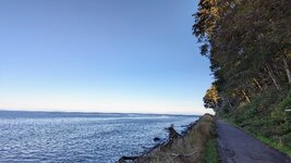
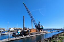
The first part of the ride was actually slightly boring. Komoot directed me to ride in the Kabacki Forest, and also told me to take the classic gravel/MTB route towards Konstancin-Jeziorna. It was a cold day initially, so I was wearing my most advanced Bioracer cycling jacket with detachable sleeves.

1696226239815.png

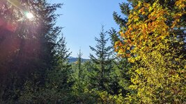
Sunshine appeared at 1 p.m. I could finally remove my sleeves! See the Mullermilch protein drink: the commercial is the cow MOOOO! :D (I was careful about the nutrition and hydration on that ride).


The Instant Karma
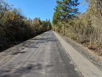
As I was pedalling through an exceptionally boring asphalt segment of the Mt. Calvary Classic Route, I could hear very loud talking behind my back. A look in the mirror and I knew it were two female roadies, apparently on their coffee ride :) While I was pedalling at some 23 km/h (I am now respecting the Euro speed restrictor of 25 km/h), the girls were a tad faster than I. The inevitable had come, and both overtook me and started slowly disappearing at the distance. No way could I catch up with them without increasing the assistance and derestricting my e-bike. Well, what to do? Only there was a barrier across the road informing about construction works and a detour. I got quite curious...

The girls took the detour, and yet another fast roadie respected the sign, so did I. (Later, it turned out the detour was all asphalt and it was pretty long!) After perhaps a kilometre or two pedalled, with the girls barely visible in front of me, my Wahoo told me to turn left soon. The girls took that left turn as well. To my surprise, the road was... all gravel! Within 30 seconds I overtook the girls at my 23 km/h while they were riding hysterically slowly on their skinny tyres... :D No idea what they did next; were I them, I would go back and continue the asphalt ride, as the gravel road was not even good for cars! :D

Mt. Calvary and Mt. Cafe Being Empty!
I should have known better. The Sunday 1st of October this year was the day of a rally of one million people organised by the opposition political parties prior to the general election to be held on 15th this month. The march called "One Million Hearts" has been hugely successful. Even if I fully support the opposition, I cannot walk or stand for a longer time, so I completely forgot about the rally happening in Warsaw during my ride!

1696227359610.png

Mt. Cafe was almost deserted, which never happens on sunny Sundays!

1696227418828.png

Mt. Cafe can brew excellent coffee, and the cake is good there but they should employ a good cook. The food was not good but expensive instead... I regret to not have ridden to the nearby Delizza restaurant!

1696227522102.png

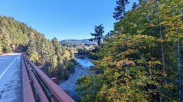
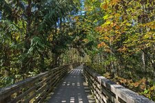
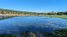
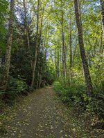
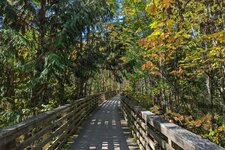
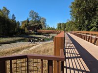
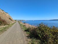
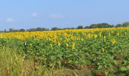
Now, Komoot did it best! My return ride was full of premium gravel roads or forest trails!

1696227602306.png

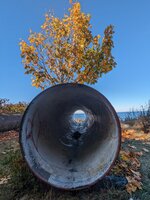
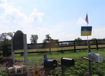
Top: "The gravel cyclists are the people who ride across the road" :D How true! The forest barrier as seen across the main road is a typical view to us, adventure riders! :D
Centre: "Stephan's Sacred Spot" nature reservation :D Many of you spell my first name wrongly. Is the sacred spot mine then? :)
Bottom: "Always Wear A Helmet!" (Literally: "The helmet is your basic thing"). Although all gravel cyclist wear helmets, there are still many cyclists that are
hostile to wearing a helmet here.

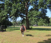
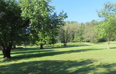
I was not avoiding riding gravel. I was not avoiding forest paths involving tree roots or sand. The off-road trauma seems to have left me! I even rode the forest paths at the sunset with my path lit by the headlight! The secret? Just ride slower... :)

1696228031544.png

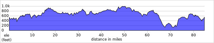
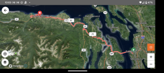
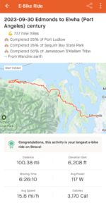
A Metric Century. I was using the main battery and a single Range Extender, with the estimated maximum range of 165 km (100+ miles). Totally doable if you are ready to ride slower and get tired during the ride! @Creo rider: for your attention; I do not ride big hills and have to be assisted during my rides but you know the SL potential very well! :)

1696228232534.png

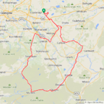
There are many darker green areas on the map: It meant gravel or forest roads/singletrack. Several areas in white or pale green meant gravel, too.
 
Last edited:
1696256497774.png


I was hoping to do this ride yesterday and had my alarm set for an early start but I woke to wind and rain so I returned to my cosy bed and had a lazy day instead! The forecast was looking more promising today anyway and thankfully they got it right for once, although it said the winds would only be around 18mph for most of the morning and increasing to 25mph but they got that wrong...it was a very blustery southwesterly! I was in 2 minds about which way to go to take advantage of the wind! I decided to go SE to Carstairs on mostly back roads to avoid the morning traffic, that turned out to be over 40 miles into the strong breeze which meant I had to change to my second battery at 42 miles but with 3500ft of elevation and a strong headwind that was pretty good going!

My ride started with roads like this which were totally deserted!

1696257147915.png

This is the nice descent down into Carstairs!

1696257275319.png

Once in Carstairs I had no choice but to take the main A70 road which would take me all the way to my turning point at Muirkirk, thankfully it wasn't too busy for a week day! This is such a fun road to ride as it rises and falls and twists and turns for over 22 miles and I got a nice surprise to see new tarmac on the big descent at Ravenstruther, I remember the road was closed for a while recently and I'm glad about that as its a fast descent and with new tarmac it was just sublime! :D Another big descent followed down to the Hyndford bridge and I decided to use the cycle path until I had to join the road again after a mile or so!

1696257761372.png

The River Clyde can just be seen here and it was flowing very fast after all the recent rain!

1696257872983.png

This is looking back down at the bridge and it was nice to see very little traffic at this time!

1696257991710.png

The farmers are still very busy even at the start of October!

1696258064059.png

You can see why I love this road so much, this is the first of many lovely descents!

1696258143528.png

The downside was the 25mph headwind though so it certainly wasn't a fast descent today! Than I had a climb but it was only a gradual one and no problem in level 2 assist! This is looking back down the road after the climb!

1696258280249.png

Soon I had a big climb up the hill towards Douglas which is thankfully followed by a lovely big descent, I stopped at the top of the climb for this photo of the Douglas Water which has 3 lochs in quick succession but most of it is hidden by the trees sadly!

1696258519998.png

I continued on towards Glespin and knew I would soon reach the rougher part of the road to Muirkirk but I got another nice surprise to see more new tarmac laid on the roughest part, that was most welcome!:D

1696258732307.png

It was only short lived though and I was soon on a rough part but I knew I would be back on smooth tarmac near Glenbuck rerservoir, the road is so good here!

1696259003527.png

Not surprisingly the reservoir is pretty full at the moment!

1696259100275.png

I was now close to Muirkirk and I was looking forward to finally having that strong breeze at my back, it starts with a big climb but is quickly followed by many awesome descents which is why I chose to do the clockwise route today and the best part is the road was resurfaced earlier this year so it was a real joy to ride it and the views weren't too shabby either!

1696259352521.png

1696259420550.png

Another couple of miles and Glengavel reservoir came into view!

1696259515693.png

1696259574018.png

Its a bit of a climb here but with a strong breeze at my back I only needed assist level 1 and I was sure enoying it, this is looking back down the hill I just climbed!

1696259712449.png

A final photo of the reservoir before some awesome descents towards Strathaven!

1696259813033.png

When I arrived in Strathaven I decided to take the road to Hamilton which would mean riding in traffic but lots of fast descents and I had a real blast flying down them! It was busy in the town centre as expected but I soon turned off the main road and joined the Clyde Valley road, which was quiet at first but unfortunately it soon became very busy and I pulled in a few times to let the traffic pass! I reached the valley and grabbed the last photo of the day of the River Clyde at Garrion Bridge!

1696260202585.png

Then it was time to tackle the Horsley Brae which is a 2 mile climb with an average gradient of 4.3%, I used level 3 assist as I had lots of battery left and eased my way up the climb! I then took the road to Newmains and used the quiet back roads all the way home with more big climbs inevitable, I soon arrived home pretty tired but what a fantastic ride it was and not a single drop of rain!😁 
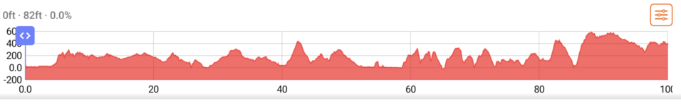
I was climbing the last hill to home and my gps was showing just over 6000ft of elevation gain, but Ridewithgps only shows 5512ft...:rolleyes:
 

Attachments

  • trip-136284725-map-full199.png
    trip-136284725-map-full199.png
    412.6 KB · Views: 58
  • elevation_profile199.jpg
    elevation_profile199.jpg
    24 KB · Views: 50
We took a lad who fancies his chances to deepest Wales a few years back, he was a friend of a friend and had bought an emtb.
He said he was up for anything.
Two hours in he started actually crying he wanted to go home , but didnt know the way.
We eased off onto fire roads to give him a break.
He sold, yes sold his ebike and bought a road bike.
I still feel bad about it.
He did say he was up for anything
I could watch an EMBN video from a ride across Wales. Not for the faint heart indeed.
 
First century ride
(Sorry long post)
1000002732.png


With summer's end and school starting up (practices, games, rehearsals, etc) I was feeling like chances for a good long ride were slipping away with along with the long days.
The weather was supposed to be gorgeous, even though it was still dreary out on Saturday morning. So with a change of clothes, a change of batteries, my charger, and some protein bars I biked down to the ferry to explore the Olympic Peninsula.

PXL_20230930_161756432.jpg

Still cloudy and in the 40's F, after getting off the first ferry.

Headed out quickly as it's not super fun with nearly all 192 cars that were on the ferry passing you on the same road. I was surprised to see a shape closing! behind me on the shoulder on one of the rolling downhills. First time in a long time a roadie has caught up to me. We chatted for a few at the red light then I let him take the lead. We parted ways at the Hood Canal Bridge as he continued his loop of the Kitsap Peninsula.

PXL_20230930_164609920.jpg

Blue skies ahead as I cross the Hood Canal bridge onto the Olympic Peninsula!
I turned off the main road to take some of the few side roads across the next stretch and avoid traffic for a while.

PXL_20230930_170458935.jpg

Nice little gravel road. Too bad it was only a couple miles.

Coming out at Eaglemount there's a nice(?) winding descent on the state highway down to Discovery Bay where the ODT starts up again. From here to Port Angeles the trail runs in sections sometimes separated, sometimes along backroads and occasionally harrowing short stretches along busy 101. Lots of bridges both big and small. Several old trestles still in use.
PXL_20230930_191351858.jpg

This is the life

PXL_20230930_194735547.jpg

Johnson Creek trestle
I stopped in Sequim at about 55 miles for lunch and a break. Still early and I still have juice so on to Port Angeles!
PXL_20230930_211217528.jpg

Railroad Bridge over the Dungeness River. This section was the only part of the day where the trail felt at all crowded - I can see why, it's a beautiful and very accessible walk/bike for young and old.


The trail eventually winds down to the water and runs along the shore for the last 4 miles into Port Angeles. Really nice ride and a good change of pace. I got into town and found a bed for the night. After dumping off my gear and taking a little break headed off to bike through town and back onto the ODT to see the bridge over the Elwha River.

PXL_20231001_001013797.jpg

Cycling on this bridge is on a whole other level!

PXL_20231001_001204854.jpg

Looking downstream

PXL_20231001_001528310.jpg

Up on top looking upstream
After looping back to town on side roads I headed down to Ediz Hook, which is what provides Port Angeles with a good harbor.

PXL_20231001_004653499.jpg

Near the base of the Hook looking out into the calm harbor
PXL_20231001_005252881.jpg

PXL_20231001_010730752~2.jpg

I headed back towards the hotel only to realize that would leave me at 98 miles so I pedaled a mile up the main drag then up the hill a few blocks and back to make the century ride official!
Screenshot_20231002-001432.png


After a shower it was time to hit that gastropub I passed earlier for a burger and a beer (or two)!
 

Attachments

  • PXL_20230930_220901504.jpg
    PXL_20230930_220901504.jpg
    461.9 KB · Views: 54
  • PXL_20231001_001511680.jpg
    PXL_20231001_001511680.jpg
    751.2 KB · Views: 64
  • PXL_20231001_000453851.jpg
    PXL_20231001_000453851.jpg
    873.9 KB · Views: 55
  • Screenshot_20231002-220316.png
    Screenshot_20231002-220316.png
    2.2 MB · Views: 53
  • PXL_20230930_220901504.jpg
    PXL_20230930_220901504.jpg
    461.9 KB · Views: 52
  • PXL_20230930_220207782.jpg
    PXL_20230930_220207782.jpg
    1.1 MB · Views: 57
  • PXL_20230930_195854446.jpg
    PXL_20230930_195854446.jpg
    459.1 KB · Views: 55
  • Screenshot_20231001-235954.png
    Screenshot_20231001-235954.png
    554.7 KB · Views: 52
  • PXL_20230930_191348784.jpg
    PXL_20230930_191348784.jpg
    789.1 KB · Views: 58
  • PXL_20230930_190738655.jpg
    PXL_20230930_190738655.jpg
    1.3 MB · Views: 60
  • PXL_20230930_220207782.jpg
    PXL_20230930_220207782.jpg
    1.1 MB · Views: 56
  • PXL_20230930_211003442.jpg
    PXL_20230930_211003442.jpg
    906.7 KB · Views: 57
  • PXL_20230930_221514445.jpg
    PXL_20230930_221514445.jpg
    391.5 KB · Views: 47
First century ride
(Sorry long post)
View attachment 163836

With summer's end and school starting up (practices, games, rehearsals, etc) I was feeling like chances for a good long ride were slipping away with along with the long days.
The weather was supposed to be gorgeous, even though it was still dreary out on Saturday morning. So with a change of clothes, a change of batteries, my charger, and some protein bars I biked down to the ferry to explore the Olympic Peninsula.

View attachment 163793
Still cloudy and in the 40's F, after getting off the first ferry.

Headed out quickly as it's not super fun with nearly all 192 cars that were on the ferry passing you on the same road. I was surprised to see a shape closing! behind me on the shoulder on one of the rolling downhills. First time in a long time a roadie has caught up to me. We chatted for a few at the red light then I let him take the lead. We parted ways at the Hood Canal Bridge as he continued his loop of the Kitsap Peninsula.

View attachment 163796
Blue skies ahead as I cross the Hood Canal bridge onto the Olympic Peninsula!
I turned off the main road to take some of the few side roads across the next stretch and avoid traffic for a while.

View attachment 163812
Nice little gravel road. Too bad it was only a couple miles.

Coming out at Eaglemount there's a nice(?) winding descent on the state highway down to Discovery Bay where the ODT starts up again. From here to Port Angeles the trail runs in sections sometimes separated, sometimes along backroads and occasionally harrowing short stretches along busy 101. Lots of bridges both big and small. Several old trestles still in use.
View attachment 163815
This is the life


View attachment 163809
Johnson Creek trestle
I stopped in Sequim at about 55 miles for lunch and a break. Still early and I still have juice so on to Port Angeles!
View attachment 163799
Railroad Bridge over the Dungeness River. This section was the only part of the day where the trail felt at all crowded - I can see why, it's a beautiful and very accessible walk/bike for young and old.


The trail eventually winds down to the water and runs along the shore for the last 4 miles into Port Angeles. Really nice ride and a good change of pace. I got into town and found a bed for the night. After dumping off my gear and taking a little break headed off to bike through town and back onto the ODT to see the bridge over the Elwha River.

View attachment 163804
Cycling on this bridge is on a whole other level!

View attachment 163801
Looking downstream

View attachment 163808
Up on top looking upstream
After looping back to town on side roads I headed down to Ediz Hook, which is what provides Port Angeles with a good harbor.

View attachment 163806
Near the base of the Hook looking out into the calm harbor
View attachment 163814
View attachment 163800
I headed back towards the hotel only to realize that would leave me at 98 miles so I pedaled a mile up the main drag then up the hill a few blocks and back to make the century ride official!
View attachment 163794

After a shower it was time to hit that gastropub I passed earlier for a burger and a beer (or two)!
Beautiful ride! We're hoping to get to parts of the ODT next summer ...
 
Just a quick ride out today with Mrs DG to pick up some windfall apples that I saw at a local farm the other day.
IMG_2450.jpeg


Not too bad, 16.6kg in total.
IMG_2449.jpeg


Update;
Apples have been prepped and part stewed. Now outside cooling before before we portion and bag them, then freeze them.
IMG_2451.jpeg

A total of 8.4 kg, so not too shabby.

Update Update:
Nine bags of loveliness for the freezer.
IMG_1104.jpeg


DG…
 
Last edited:
I keep forgetting to look for the old disused railway down here by my dads, I walked it 50 years ago, through the tunnels as well and I though maybe it would be rideable.

But no, its all completely overgrown or turned into fenced off private land.
Screenshot_20231004-001442~2.png


Some of it is walkable but theres strictly no cycling signs everywhere, so instead I did a little loop around the forest on a bridle path.
This suddenly went a foot deep and nearly had me off.
Screenshot_20231004-001143~2.png


Got a wave from a vintage tractor driver
Screenshot_20231004-001344~2.png


It brought me out to a cute thatch cottage village called Woodleigh
Screenshot_20231004-001921~2.png


Started raining just as I left the village for a mile long climb back to the van.
Nice hour ambling along through the woods, some pretty steep climbs, some deep mud, but as usual, the entire thing to myself
Screenshot_20231004-002006~2.png
 
Congratulations!
Thank you!

53 years before my first century ride but only 24 hours for my 2nd :)

2nd century ride
Sunday, I awoke to find that government shutdown had been averted which killed the fantasy I had been harboring of getting to bike up the iconic Hurricane Ridge climb without cars if the National Park gates remained closed due to the shutdown. It would have been foolish to bike 40 miles and nearly 6000 vertical feet before trying to do the 80 mile ride home.

Plan B was to bike 55 miles to Port Townsend where I could catch a ferry to Whidbey Island. From there 30 miles down Whidbey to the next ferry to Mukilteo and then a familiar 15 miles home.

I felt surprisingly decent given I'd pedaled 100 miles the previous day. Settled into a rhythm and realized at about 50 miles that I hadn't had more than a few sips of water. Still, the legs were tired so I used a little more assist to keep a good pace going on the hills - over 6500 ft of climbing.

Screenshot_20231002-220717.png

Screenshot_20231002-000230.png

Great weekend - 200 miles + 3 ferries in under 33.5 hours! I was a little achy yesterday but everything loosened back up by midday at work. Still, will probably take it easy this week :)
 

Attachments

  • PXL_20231001_195740540.jpg
    PXL_20231001_195740540.jpg
    504.6 KB · Views: 43
  • Screenshot_20231002-221059.png
    Screenshot_20231002-221059.png
    89.2 KB · Views: 47
  • PXL_20231001_195821510~2.jpg
    PXL_20231001_195821510~2.jpg
    460.5 KB · Views: 55
  • PXL_20231001_193420297.jpg
    PXL_20231001_193420297.jpg
    795.7 KB · Views: 55
IMG_1380.JPG


I rode towards the James River yesterday enjoying the fast descents down the flood plain. No wind...no traffic...almost no one...but this one horse who after a nose scratch departed broken hearted from my empty hand.


Great weather yesterday for a ride towards the James River.
 

Attachments

  • IMG_1379.JPG
    IMG_1379.JPG
    970 KB · Views: 50
  • IMG_1370.JPG
    IMG_1370.JPG
    757.4 KB · Views: 54
  • IMG_1384.JPG
    IMG_1384.JPG
    432.2 KB · Views: 50
  • IMG_1351.JPG
    IMG_1351.JPG
    610 KB · Views: 49
Back