2023 - Our Rides in Words, Photos, Maps and Videos

I made this video with the help of my imaginary californian friend.

It gives it a weird vibe.

A whole video of things you didnt know and are no better off knowing.

Thanks for all of those juicy facts! I've committed them to memory and plan to toss them out at parties.
;^}

Kidding aside, actually enjoyed hearing about the beautiful scenery. But you're a much better narrator.

Show of hands: How many ebikers here feel a need to carry electrical tape?

Too bad we've come to the point of planned retreats in coastal areas due to sea level rise. Big issue in SoCal as well. But here, the driving risks relate mainly to winter storm waves. With higher water, big waves mean more flooding and impact damage in low-lying areas and accelerated sea cliff failure up on the bluffs. Many fancy homes and resorts and restaurants built right on the brink. No room to move them back, and ugly cliff fortifications are only expensive bandaids with no hope of long-term success.
 
Last edited:
Today’s ride

IMG_2323.jpeg


DG…
 
Is this locally discarded or blown in?
Seems unbelievable so many people would be that selfish.
Locally discarded from the trades and workers, not the landowners. The tall roadside grass hides the litter through the seasons, so it tends to "grow" if not cleaned up at least once a year. Blow-ins are rare. Trash (mostly empty feed bags) are sometimes blown out of the open beds of trucks, but not terribly often.

Our area has a good number of "adopted roads", which is a program through Virginia Dept of Transportation. Adopted roads are cleaned a minimum of 2x a year. The rest of the roads are on their own, cleaned by the generousity of people who feel a need to help out. VDOT offers free bags, gloves, and pickup sticks to anyone who wants to clean a road. They also provide pickup for the filled bags. You simply leave them alongside the road, and the daily road "scouts" will see them and report a pick up.
 
Its not just the littering, its people with tipper trucks just dumping waste anywhere they can
Oh, lord. That's downright disgusting.😠

I have seen only two instances of "tipping" around here - both were a truck load of used tires alongside the gravel roads. Once I saw them a quick call to VDOT had a clean-up crew out the following day to pick up and remove all the discarded tires. VDOT is highly responsive if you call with a concern.

The busy state 4 lane highways are a no man's land that VDOT prefers to clean themselves twice a year. For the federal highways I remember in the past seeing cleanup crews comprised of federal prisoners and one law enforcement "overseerer" with a rifle. Guess cleaning litter was a way for prisioners to do community service for points, plus it got them out of the prison environment for a day, and into fresh air, doing something constructive for society. Haven't seen that for ages now, come to think of it.
 
Many fancy homes and resorts and restaurants built right on the brink. No room to move them back,
That sounds like the Outer Banks in North Carolina. They keep "enriching" the beaches with millions of dollars worth of sand dredged up from off shore sand bars, only for the Atlantic storms to batter the shoreline and erode the sands back into the ocean.

In the past decade the sea level rise has been particularly destructive to shoreline homes. More so than ever in the past.
Yes, also NC's Brunswick County coast, home to Holden Beach, an oft-visited favorite for decades. Last time I was there, in 2017, the city had just spent $15M on sand replenishment to very good result. But the last night I was there, storm surge and surf from Hurricane Irma (by then a tropical depression far inland) removed every last grain.

Once dreamed of living on Holden, but between climate change and replacement of most of the charming, rentable beach houses with ugly, ostentatious McMansions, it's lost its appeal. Hate to admit that part of me wishes they'd all get swept away.

Many of Holden's old houses were named — mostly with predictable stuff like Sunset, Reflections, Meditation, etc. My favorite name, from long before climate change, was "Bought It Anyway". And thinking it was just about the money back then, I totally got that. Now, it just sounds foolish.
 
They did it on our beach, moving one end of a 20 mile stretch to fill in lost sand.
Now the filled in bit has swallowed the entire sea wall and starting to fill in the boating lake.
 
Since moving to coastal San Diego County a year ago, I've been on a quest to understand waves and beaches and sea cliffs and their many counter-intuitive interactions on a technical level. Coastal engineering (seawalls, groins, jetties, piers, breakwaters, docks, harbors, etc.) comes up often. Gotta be one of the most challenging subdisciplines in all of civil engineering.

The recurring theme: Any attempt to control sand migration will eventually either fail, cause an even bigger problem somewhere else, or both. Won't take much sea level rise to make all this much worse.

In the US, sandy beaches turn out to be important economic engines in all coastal states. Surely ditto in the UK and other countries. Prospects aren't good.
 
Last edited:
We had a spectacular day cycling an out and back metric century starting from the Legacy Trail at Canmore and along the Bow Valley Parkway to Castle Mountain. The Fall colors were sublime. It was a long day in the saddle but worth every minute. A few teasers before I hit the hay. More to come.

Vermillion Lake

PXL_20230922_230201424.jpg


Ebikes appear to be a hot commodity here and rightfully so. People can now get to POIs where they would otherwise have to drive to.

ebikes galore.jpg

PXL_20230922_215135662.jpg

GH012468 - frame at 0m26s.jpg
 
Thanks for all of those juicy facts! I've committed them to memory and plan to toss them out at parties.
;^}

Kidding aside, actually enjoyed hearing about the beautiful scenery. But you're a much better narrator.

Show of hands: How many ebikers here feel a need to carry electrical tape?

Too bad we've come to the point of planned retreats in coastal areas due to sea level rise. Big issue in SoCal as well. But here, the driving risks relate mainly to winter storm waves. With higher water, big waves mean more flooding and impact damage in low-lying areas and accelerated sea cliff failure up on the bluffs. Many fancy homes and resorts and restaurants built right on the brink. No room to move them back, and ugly cliff fortifications are only expensive bandaids with no hope of long-term success.
I would leave the driveway without tape and zip ties.
They are pursuing a retreat policy in the UK, though I do believe its all part of trying send the climate message home to a sceptical population.
I checked wiki for the village and its actually two hundred years for a .5m rise to abandon it at present sea rise speed..which is obviously not guaranteed.
 
I made this video with the help of my imaginary californian friend.

It gives it a weird vibe.

A whole video of things you didnt know and are no better off knowing.
An excellent video. Crisp, understandable English and so many interesting facts! Thank you!
Show of hands: How many ebikers here feel a need to carry electrical tape?
It is my dream CR could ride a decent e-MTB one day ;) The part of 'resetting the BMS' was depressing!

Meanwhile, some pics from my Friday ride (Vado 6.0). I was riding in a very low assistance (20/100%) that gave me a good workout, especially as I had to counter a strong headwind on the outbound part of my trip!

1695453037965.png

In the front of Specialized Warsaw. The logo is the Warsaw Mermaid riding a bike :D

1695453197309.png

It is 20 miles the shortest way from my place! An easy ride!

1695453361219.png

Summer, please last! Another gorgeous, warm and sunny day! It is a rare warm September here (last year, I had to wear winter clothes already!) I was riding the "Count's Road" (Count like in the aristocratic title). It is the best way to ride eastwards from my place south of the Chopin Airport, especially because of the minimal traffic.

1695453588234.png

I collected a new Specialized Echelon II MIPS helmet, and bough a pair on new cycling gloves. I got used to wearing the gloves as it means comfort on long rides! It was @Brix to select the colour of my new helmet, and I like it very much! ♥️

1695453737327.png

Instead of pizza, I chose the staple Polish food for the lunch :)

1695454055766.png

68.8 km for the day. You can see how the presence of the Chopin Airport (which location is very convenient for the passengers!) affects my rides. It was the first time when I checked the size of the Warsaw's southern quarter (Ursynów). The straight line is 6 km long, and that's a lot for a city of the size of Warsaw!
 
An excellent video. Crisp, understandable English and so many interesting facts! Thank you!

It is my dream CR could ride a decent e-MTB one day ;) The part of 'resetting the BMS' was depressing!

Meanwhile, some pics from my Friday ride (Vado 6.0). I was riding in a very low assistance (20/100%) that gave me a good workout, especially as I had to counter a strong headwind on the outbound part of my trip!

View attachment 163093
In the front of Specialized Warsaw. The logo is the Warsaw Mermaid riding a bike :D

View attachment 163094
It is 20 miles the shortest way from my place! An easy ride!

View attachment 163095
Summer, please last! Another gorgeous, warm and sunny day! It is a rare warm September here (last year, I had to wear winter clothes already!) I was riding the "Count's Road" (Count like in the aristocratic title). It is the best way to ride eastwards from my place south of the Chopin Airport, especially because of the minimal traffic.

View attachment 163096
I collected a new Specialized Echelon II MIPS helmet, and bough a pair on new cycling gloves. I got used to wearing the gloves as it means comfort on long rides! It was @Brix to select the colour of my new helmet, and I like it very much! ♥️

View attachment 163097
Instead of pizza, I chose the staple Polish food for the lunch :)

View attachment 163098
68.8 km for the day. You can see how the presence of the Chopin Airport (which location is very convenient for the passengers!) affects my rides. It was the first time when I checked the size of the Warsaw's southern quarter (Ursynów). The straight line is 6 km long, and that's a lot for a city of the size of Warsaw!
It is my dream CR could ride a decent e-MTB one day ;) The part of 'resetting the BMS' was depressing!

My friends £5000 emtbs break down more than mine 😂.
One is on its third motor, theyve all had the batteries replaced.
Its an emerging tech I guess, that black specialised I rode up the mountain has had the motor and the battery replaced, its not a year old.
Its just a bms mismatch with the controller, nothing a bit of wood and tape cant fix 😂
 
I would have preferred it narrated with your piratey accent.
Awesome ride tho. I can almost smell pine trees. 😆 lol.
 
A Rocky Mountain Getaway - Canmore to Castle Mountain Junction (Part 1)

Just to let you know that this is a long trip report which is why I’ve wisely decided to submit the start and return legs in two separate posts if that makes any difference. :oops:

We capped of a rather mundane week with an epic ride in the Canadian Rockies yesterday. Our initial plan was to cycle from the Fenlands Rec Center in Banff to Baker Creek Resort and back a total distance of just under 100km. It wasn’t until my wife noticed on the drive towards the townsite that our annual parks pass had expired. Sooo…with that in mind, we made our way to the park gate and queued up with the hundreds of other vehicles most of which were clearly from out of province. It was incredible to see this many people continue to come here even after the summer holiday travel season. After waiting in line for 15 minutes and with traffic trickling along at a snail’s pace, we had enough as it was approaching noon hour. Driving into Banff to purchase a pass would have eaten up more time so it was at that moment that we decided to lose our place in line, turn back onto the TC Hwy and drive the 4km back to Canmore where we would eventually start our ride. This would be the third time that we’ve cycled this route but have never done so before on analog road bikes. The weather conditions were ideal with little wind and with fall approaching it was a bit on the cool side which was much to my wife’s liking.

Web capture_23-9-2023_11958_ridewithgps.com.jpeg

Web capture_23-9-2023_11614_ridewithgps.com.jpeg

Web capture_23-9-2023_12154_ridewithgps.com.jpeg


Our ride began at the Canmore Visitor Info Center which was also the start of the Legacy Trail.

PXL_20230922_185955289.jpg


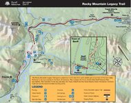
The Legacy Trail is a gorgeous 26 km paved parkway in the heart of the Rocky Mountains that runs parallel to the TC Hwy and starts from the SE terminus at Canmore to the Banff wildlife gate at the corridor to the Bow Valley Parkway. It was built in honor of Banff National Parks 125 anniversary. From the Banff Townsite, one is able to cycle a section of the Bow Valley Parkway/Hwy 1A which is closed to traffic from May 1 to June 25 and Sept 1 to Oct 1.
Web capture_23-9-2023_84914_.jpeg

Plenty of views along the Legacy Trail. For many locals, it’s just another MUP used for commuting between the two townsites. What an invigorating way to start one’s work week wouldn’t you agree?

PXL_20230922_192928740.jpg

PXL_20230922_192952834.jpg

GH012479 - frame at 0m20s.jpg


Made from recycled plastic, these bright red Adirondack chairs are placed in various locations within the confines of the park. These two are at the Valleyview picnic area along the Legacy Trail.


PXL_20230922_193154083.jpg


The only recumbent that we came across but ebikes were in abundance as well as those on non powered rides.

GH012470 - frame at 0m25s.jpg

GH012472 - frame at 0m13s.jpg

GH012478 - frame at 0m33s.jpg


Cycling down Banff Avenue. As a kid, my dad used to take the entire family and haul our old single-axle travel trailer to Tunnel Mountain or Two Jack Lake for weekend outings. It was truly an adventure for us youngsters and a way for my pop to escape the stress of work that he left behind. Those days are history and Banff has lost much of its rustic charm to over zealous development and upscale boutiques. Nevertheless, it’s a mecca for tourism and will always carry special moments for those who either are only here for the day or fortunate enough to plan a multi day trip.

Banff Avenue.jpg


Just outside of the townsite, we stopped briefly to admire the views along Vermilion Lakes Road. The fall colors were just starting to emerge and the reflection off the lakes with the majestic backdrop of Rundle Mtn speaks for itself.

PXL_20230922_201151382.jpg

PXL_20230922_201317635.jpg

PXL_20230922_201326300.jpg


The junction at Hwy 1A and the TC Hwy overpass.

Hwy 1A, TC Junction.jpg


Bienvenu! The start of our car(e)free run along the Bow Valley Parkway. Note: Vehicles are still allowed on the west section of the parkway from Johnston Canyon to Whitehorn Road near Lake Louise so it wasn’t all fun and games.

GH012480 - frame at 0m46s.jpg


Site of a prescribed burn that took place back in 1993.

PXL_20230922_204359242.jpg


Sai climbs her way up the final crest towards Castle Junction.

PXL_20230922_210909186.jpg

GH012491 - frame at 0m17s.jpg


A little over two hours before arriving at Castle Mountain Junction. We stopped for a quick snack before turning south for the return leg back to Canmore.

Castle Mountain Junction.jpg
 
Last edited:
Return to Canmore (Part II)

After our brief stay at Castle Mtn Junction, we headed back towards our start point at Canmore. Here, we stopped at a pull out at Moose Meadows with Pilot Mountain seen just right of center.

PXL_20230922_215130632.jpg


Sai makes her way along the parkway with a spectacular view of the Sawback Range. The ‘Hole in the Wall’ , a natural cave on the side of Mt. Cory can be seen in the second image.

PXL_20230922_223342747.jpg

PXL_20230922_223357296.jpg


Not my pic but this gives you a general idea of stunning view from the entrance of the cave. Not a hike for the faint of heart. o_O

Castleguard-24.jpg


A common site are bighorn sheep that frequent this stretch of road where they seek out salt deposits to get essential minerals.

PXL_20230922_223838227.jpg


We approach a group of ebikers who were admiring the view from this pullout.

GH012508 - frame at 0m12s.jpg


Vista of the Bow River and beyond from above the parkway. We enjoyed the views on the return leg more so than at the start of the ride.

PXL_20230922_223943932.jpg


This concludes the end of the Bow Valley Parkway as we continue back along the Legacy Trail.

GH012510 - frame at 0m41s.jpg

PXL_20230922_224838525.jpg

GH012511 - frame at 0m2s.jpg


Of course, a trip here wouldn’t be the same without an obligatory train pic. 👍

PXL_20230922_233016920.jpg


Nearing the end of the ride, I encountered an exuberant and much more youthful roadie along Legacy on the saddle of a gorgeous carbon Trek Domane who was keenly interested in my rear helmet mounted Bontrager branded Flare flasher. He was so impressed by its brightness that he asked me where I purchased it. ‘That’s Awesome, I’m getting one!’, he replied and subsequently took off in a flash never to be seen again.

GH012522 - frame at 0m39s.jpg

GH012522 - frame at 0m58s.jpg


Some fall images as we close in on the end of the ride.

PXL_20230922_234022612.jpg

PXL_20230922_235934446.jpg
 
Last edited:
Return to Canmore (Part II)

After our brief stay at Castle Mtn Junction, we headed back towards our start point at Canmore. Here, we stopped at a pull out at Moose Meadows with Pilot Mountain seen just right of center.

View attachment 163142

Sai makes her way along the parkway with a spectacular view of the Sawback Range. The ‘Hole in the Wall’ on the side of Mt. Cory can be seen in the second image.

View attachment 163143
View attachment 163144

Not my pic but this gives you a general idea of stunning view from the entrance of the cave. Not a hike for the faint of heart. o_O

View attachment 163145

A common site are bighorn sheep that frequent this stretch of road where they seek out salt deposits to get essential minerals.

View attachment 163147

We approach a group of ebikers who were admiring the view from this pullout.

View attachment 163146

Vista of the Bow River and beyond from above the parkway. We enjoyed the views on the return leg more so than at the start of the ride.

View attachment 163148

This concludes the end of the Bow Valley Parkway as we continue back along the Legacy Trail.

View attachment 163149
View attachment 163153
View attachment 163150

Of course, a trip here wouldn’t be the same without an obligatory train pic. 👍

View attachment 163154

Nearing the end of the ride, I encountered an exuberant and much more youthful roadie along Legacy on the saddle of a gorgeous carbon Trek Domane who was keenly interested in my rear helmet mounted Bontrager branded Flare flasher. He was so impressed by its brightness that he asked me where I purchased it. ‘That’s Awesome, I’m getting one!’, he replied and subsequently took off in a flash never to be seen again.

View attachment 163155
View attachment 163156

Some fall images as we close in on the end of the ride.

View attachment 163157
View attachment 163158
Brilliant!
 
Back