I am trying to guess what this car was built from. I think it is a Mercury coupe, 1949, 1950 or 1951, chopped, lowered and otherwise heavily modified. Very nice!A thing of beauty!!!View attachment 61644
You are using an out of date browser. It may not display this or other websites correctly.
You should upgrade or use an alternative browser.
You should upgrade or use an alternative browser.


Stefan Mikes
Gravel e-biker
- Region
- Europe
- City
- Mazovia, PL
During A Czech Lunch
The Czech take the matters of lunch very seriously, and inns & restaurants are full around the noon. Here, a bike rack during lunchtime at an inn in the very small Czech town of Hejnice. You can see two Haibikes parked there.
Jacek and I found e-bikes very popular in Czech Republic, which is a mountainous country. People there understand it is not about any "cheating" but you'd rather like to avoid suffering during your climbs and enjoy the pleasures of your downhill ride.
It is possible to rent e-bikes in the Czech Republic, and even in Poland (areas with a lot of tourists qualify). We were very surprised to see a young Czech couple riding Kross mid-drive e-bikes (Kross is a budget-friendly Polish bike brand).
Last edited:
D
Deleted member 18083
Guest
A place to take a rest …

Right : Pandanus – see photo below
Distance : Moreton Island and the ever-present cloud bank over the warm current moving south from the tropics.

Woody Point, Moreton Bay
Left : Norfolk Island PineRight : Pandanus – see photo below
Distance : Moreton Island and the ever-present cloud bank over the warm current moving south from the tropics.
Pandanus tectorius
RabH
Well-Known Member
I can think of worse places to take a rest!A place to take a rest …
View attachment 61603
Woody Point, Moreton BayLeft : Norfolk Island Pine
Right : Pandanus – see photo below
Distance : Moreton Island and the ever-present cloud bank over the warm current moving south from the tropics.
View attachment 61604
Pandanus tectorius
")
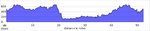
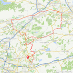
I was hoping for a long ride today but I had to settle for a lovely 52 mile ride, more than happy with that! Yet another beautiful day (thunderstorms expected from tomorrow until Wednesday) with a strong easterly breeze which helped to keep me cool in the 21C heat which is hot for here!
I usually ride with the breeze behind me at the start of my ride but I opted for the opposite today which meant I had a lovely tailwind for over 12 miles and with very little climbing it was very enjoyable indeed!It was soon time to start climbing again though but I had plenty battery power left for the last 17 miles so I was able to use level 2 assist to get up the climbs and save my old legs!
240 miles covered already in August, 3,814 miles for the year so far which means I only need another 85 miles to equal last years total I suppose some good things have come from this years crisis!
Attachments
-
 elevation_profile183.jpg21.6 KB · Views: 460
 -
 trip-54013709-map-full96.png427.2 KB · Views: 458
 -
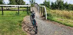 20200809_101009.jpg880.1 KB · Views: 467
 -
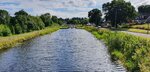 20200809_101027.jpg652.8 KB · Views: 480
 -
 20200809_101034.jpg701.2 KB · Views: 458
 -
 20200809_102008.jpg688.3 KB · Views: 487
 -
 20200809_103257.jpg305.2 KB · Views: 468
 -
 20200809_103801.jpg408 KB · Views: 467
 -
 20200809_105200.jpg436.3 KB · Views: 478
 -
 20200809_105203.jpg391.3 KB · Views: 471
 -
 20200809_105206.jpg477.4 KB · Views: 486
 -
 20200809_105221.jpg747.5 KB · Views: 477
 -
 20200809_113412.jpg308 KB · Views: 468
 -
 20200809_113415.jpg381 KB · Views: 453
 -
 20200809_113417.jpg379.7 KB · Views: 450
 -
 20200809_113628.jpg723.9 KB · Views: 477
 -
 20200809_113637.jpg428.9 KB · Views: 462
 -
 20200809_113639.jpg506.7 KB · Views: 456


Chancelucky2
Well-Known Member
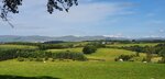
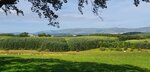
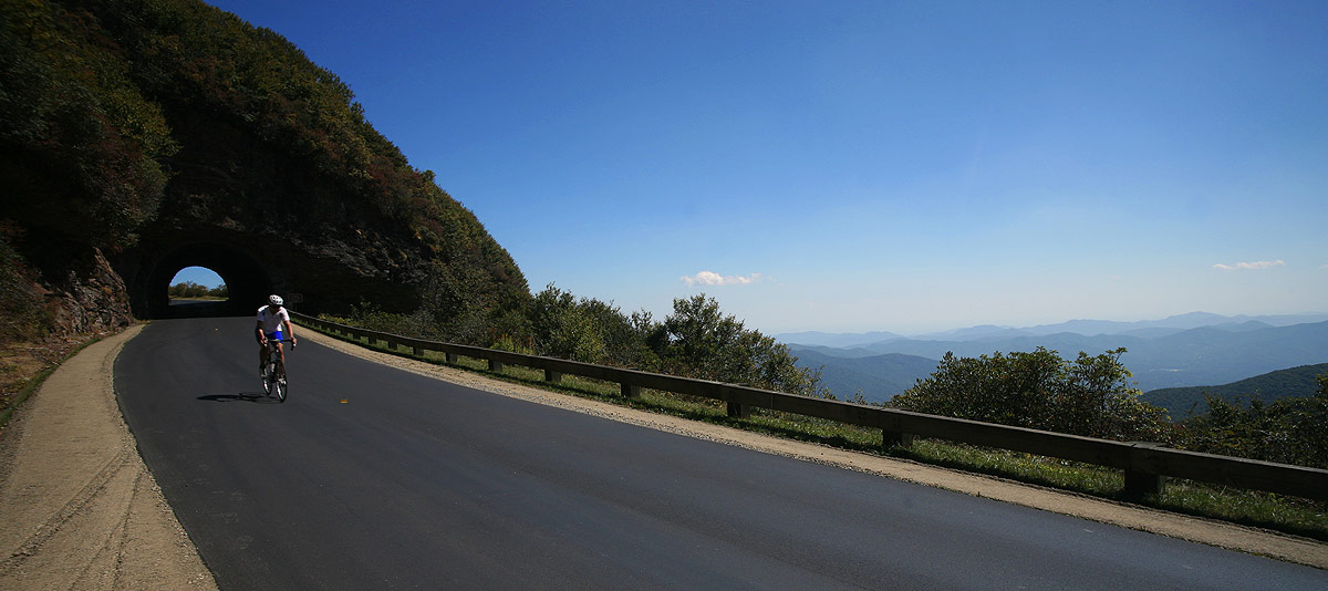
Blue Ridge Parkway near Linville, North Carolina. I last road it (Virginia end) more than 30 years ago. It lives up to its reputation as possibly the most beautiful paved ride in America. At this point in my life, the e-bike motor makes this kind of ride much more manageable. My daughter-in-law was on a carbon fibre road bike and she wore out before I did. I'm finding the Trek Crossrip+ to be wonderfully versatile yet again. I wouldn't do extreme single track with it, but I wouldn't do this kind of ride with a dual suspension mountain bike either.
Attachments
Chancelucky2
Well-Known Member
Tell us more about the road...what about the traffic...elevation etc. I live in Central VA and might like to try it
Here, it's very close to Mount Mitchell, the highest mountain in the Appalachians. Elevation near here is about 4,300 feet. It's a fair amount of climbing and dropping. It's one lane in each direction with a minimal shoulder in spots, but as I said the cars are very respectful, because there's a fair number of other cyclists on it. (virtually all road bikes) . There are a lot of outlook spots, so plenty of places to pull over, but water and bathrooms aren't exactly easy to find.
I would recommend bringing your own food.
Bicycling the Parkway - Blue Ridge Parkway (U.S. National Park Service)
Bicycling The Parkway
Beginner's Guide To Cycling The Blue Ridge Parkway
Beginner's Guide To Cycling The Blue Ridge Parkway. The Blue Ridge Parkway may have been designed as a scenic byway for motorists, but it has become a
 www.blueridgeparkwaydaily.com
Last edited:
RandallS
Well-Known Member
- Region
- Canada
- City
- Calgary
Nice to see somewhere were there isn't a requirement for a thousand locks.During A Czech Lunch
The Czech take the matters of lunch very seriously, and inns & restaurants are full around the noon. Here, a bike rack during lunchtime at an inn in the very small Czech town of Hejnice. You can see two Haibikes parked there.
Jacek and I found e-bikes very popular in Czech Republic, which is a mountainous country. People there understand it is not about any "cheating" but you'd rather like to avoid suffering during your climbs and enjoy the pleasures of your downhill ride.
It is possible to rent e-bikes in the Czech Republic, and even in Poland (areas with a lot of tourists qualify). We were very surprised to see a young Czech couple riding Kross mid-drive e-bikes (Kross is a budget-friendly Polish bike brand).
View attachment 61685
I presume the restaurant overlooks the bike area, but even then, it's refreshing to see.
Stefan Mikes
Gravel e-biker
- Region
- Europe
- City
- Mazovia, PL
People eat outside under a wooden roof, so everybody can keep their eye on the bikes. Still, the Republic is a very relaxed and friendly country. (It is probably the only world's nation that calls their own country simply "The Republic").I presume the restaurant overlooks the bike area, but even then, it's refreshing to see.
P.S. Have cash on you. The Czech don't like credit cards, especially in small locations. We paid in Polish Zloty and got the change in Czech Crowns.
P.S.2 A single world's country that is not happy with Coke and Pepsi, either. They make their own Kofola. Beer is the cheapest beverage. A half liter glass costs one U.S. dollar at the inn.
Last edited:
Anna
Well-Known Member
- Region
- USA
Restaurants are still locked down.... my attempt to toast a bagel post ride today...Tonight's dinner. A KobeDogThe size of the plate was 1 ft. (We rode for 85 km with 1500 m elevation gain etc today)
View attachment 61641


Attachments

RandallS
Well-Known Member
- Region
- Canada
- City
- Calgary
At least it has some colour! For example, the Brits drive me crazy with their beige toast, and of course you have to leave it until it's cold. To each their own I guess... Another first world problem...Restaurants are still locked down.... my attempt to toast a bagel post ride today...
Stefan Mikes
Gravel e-biker
- Region
- Europe
- City
- Mazovia, PL
I must add I like English food
Sierratim
Well-Known Member
- Region
- USA
- City
- Nevada City, CA & Paradise Valley, AZ
Back to bike rides...
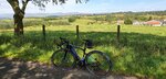
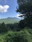
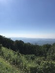
I rode down to Edwards Crossing on the S Yuba River for my ride yesterday; another ride I wouldn't be able to do without an ebike.
+

I finally got around to setting up the Komoot app with the free local map package. It provided voice directions for this ride. Very nice.

The bike's display and the app were off my less than 1 mile after the 30+ mile ride. The app records total 'on' time. The bike auto pauses when I stopped for water, etc and logged ~30 minutes less time. I'll pause the app next time.

This portion of the river is BLM land with less restrictions than the State park controlled Perdon Crossing bridge I posted about earlier. The net effect is more people with some camping along the river.

Constructed in1904 the bridge is 4 miles upsteam from the Purdon Crossing bridge and is linked by a popular hiking trail. The bridged was refurbished in 1989 with additional work in the planning stages.

The emerald swimming holes are the Summer attraction. They stretch for miles in both directions with frequent selcuded beaches. The road to this crossing is now paved making it very popular with parking at a premium. My route took me a less direct route that include 3 miles of gravel road.

After the river I rode into the neighboring town to check out their new al fresco dining in a closed off street section of downtown. Very pleasant. I think they should do this every Summer, 'pest' or not!
After nearly 3,800 feet of climbing and 22 miles I had to switch to the 2nd battery here; borrowed from my wife's bike. It was about 9 more miles home with a couple of decent climbs to go. Make it home with 70% charge on the 2nd battery.
So far, so good with Komoot app. I'll be spending some more time with it but I like it. Cell service is generally not available on these routes so I download the maps onto an expanded micro-SD card in my phone. Worked very well.
I rode down to Edwards Crossing on the S Yuba River for my ride yesterday; another ride I wouldn't be able to do without an ebike.
+
I finally got around to setting up the Komoot app with the free local map package. It provided voice directions for this ride. Very nice.
The bike's display and the app were off my less than 1 mile after the 30+ mile ride. The app records total 'on' time. The bike auto pauses when I stopped for water, etc and logged ~30 minutes less time. I'll pause the app next time.
This portion of the river is BLM land with less restrictions than the State park controlled Perdon Crossing bridge I posted about earlier. The net effect is more people with some camping along the river.
Constructed in1904 the bridge is 4 miles upsteam from the Purdon Crossing bridge and is linked by a popular hiking trail. The bridged was refurbished in 1989 with additional work in the planning stages.
The emerald swimming holes are the Summer attraction. They stretch for miles in both directions with frequent selcuded beaches. The road to this crossing is now paved making it very popular with parking at a premium. My route took me a less direct route that include 3 miles of gravel road.
After the river I rode into the neighboring town to check out their new al fresco dining in a closed off street section of downtown. Very pleasant. I think they should do this every Summer, 'pest' or not!
After nearly 3,800 feet of climbing and 22 miles I had to switch to the 2nd battery here; borrowed from my wife's bike. It was about 9 more miles home with a couple of decent climbs to go. Make it home with 70% charge on the 2nd battery.
So far, so good with Komoot app. I'll be spending some more time with it but I like it. Cell service is generally not available on these routes so I download the maps onto an expanded micro-SD card in my phone. Worked very well.
PatriciaK
Well-Known Member
- Region
- USA
- City
- Pacific Northwest and Piedmont Triad
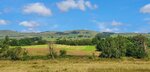
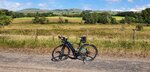
Another beautiful day, another beautiful ride  .
.
There really aren't any quiet back roads around here in the summer, so we decided to get out early. For us. Which means around 1000 . Not too much traffic at that hour on a Sunday.
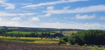
Nice views across the water:

And we found a very enthusiastic Seahawks fan:

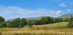
Returning full circle, enjoyed the view down the trail across the harbor:

Did I mention it's pretty hilly on the island where we live?

That's it for today...

.There really aren't any quiet back roads around here in the summer, so we decided to get out early. For us. Which means around 1000
. Not too much traffic at that hour on a Sunday.Nice views across the water:
And we found a very enthusiastic Seahawks fan:
Returning full circle, enjoyed the view down the trail across the harbor:
Did I mention it's pretty hilly on the island where we live?
That's it for today...
Sierratim
Well-Known Member
- Region
- USA
- City
- Nevada City, CA & Paradise Valley, AZ
10AM is generally 'early' for us as well, though I've been know to get out as early as 9AM on a warm day...Another beautiful day, another beautiful ride
There really aren't any quiet back roads around here in the summer, so we decided to get out early. For us. Which means around 1000
Nice views across the water:
View attachment 61804
And we found a very enthusiastic Seahawks fan:
View attachment 61802
Returning full circle, enjoyed the view down the trail across the harbor:
View attachment 61806
Did I mention it's pretty hilly on the island where we live?
View attachment 61808
That's it for today...
View attachment 61811

D
Deleted member 18083
Guest
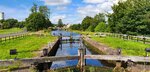
Amongst the mangroves …


The lower distances are the outward journey (and the higher the return); add them together for an approximate total (which will depend on whether the same route was ridden out and back).
Deception Bay, Queensland
There's no need to get off your bike to appreciate the mangroves: they're right next to the cycleway.The lower distances are the outward journey (and the higher the return); add them together for an approximate total (which will depend on whether the same route was ridden out and back).
Last edited by a moderator:
Stefan Mikes
Gravel e-biker
- Region
- Europe
- City
- Mazovia, PL
The Big Day, or Exploring Jizera Mts (Czech Republic & Poland)
Area-wise, France is smaller than Texas, Germany is smaller than Montana, and Poland is a tad smaller than New Mexico That is to explain the distance from central Mazovia to Jelenia Góra of some 460 km (285 mi) meant "driving through half of Poland" and it took a professional driver (my brother Jacek) as many as 6 hours. (I'll cover our last Friday's and Sunday's exploits in separate posts). Now, right to the essence: The Jizera Mts ride!
Sudety Mts, the mountains essential to Lower Silesia and to at least three Czech regions are divided into many different ranges (I've already been to the Table and Owl Mts). The highest range in Sudety are Karkonosze Mts, which are proper for hiking and expert-level mountain biking. The Jizera Mts (German: Groß Iser, Polish: Góry Izerskie, Czech: Jizerské hory) are located westwards of Karkonosze, and still are "true" mountains albeit these are more forgiving to a cyclist, especially to a road one. Not that these are too easy, oh no.
Jacek and I drove to Jakuszyce on Saturday morning. I was trying to recollect with what I could associate that location name. Right! A cross-country skiing area! And the Polish-Czech border pass. Of course!

Crossing the Czech border. Except of the covid lockdown time, crossing borders in EU is like going to another American state inside the U.S., or to a Canadian province inside Canada.
We had a fabulous descent to Harrachov. It was very steep, and I was keeping at 50 km/h (30 mph) on my Vado (as I feel there are slight ride stability issues above 45 km/h or 28 mph on that e-bike), while Jacek was happily riding at some 61 km/h (38 mph) on the Giant Trance E+. No time to take pictures...

Well-known ski-jumping hills (Large & Normal) named Certak in Harrachov, CZ. Ski-jumping is an extremely popular discipline in German-speaking and Nordic countries as well as in Poland, Czech Republic and Slovenia. (No Slovak competitors though!) The hills do not look impressive in the summer. They shine in the winter!

We realised there would be some climbing when we met the first switchbacks. Soon, we got to the location of Korenov, where we took a very short rest opposite a train station. A couple of young people rode up on Polish Kross mid-drive e-bikes. And I made a blunder. I greeted them with "Dzień dobry!" in Polish, and it was met with silence. Oops! "Dobry den!" I tried better. They smiled and returned the greeting. (I simply forgot in what country I was). Later, I was greeting people with simple "Ahoy!", which is the Czech informal and popular greeting (equivalent to "Hi!"). How came a land-locked nation chose that nautical term is unclear but it tells you a lot about the exceptional Czech sense of humour

We were constantly ascending. Here, in the village of Polubny.

A statue of the patron of Lower Silesia, St. John Nepomucene, a Bohemian saint. The statue was erected here in 1824. At that time, Bohemia was a part of the Austrian Empire, and the village was known as Paloun.

Finally, our ascent came to the end, and we could see (together with many other people) the Souš, an artificial lake created in 1915 by constructing a stone dam. The lake is a potable water reservoir and is protected against intrusion.
The Magnificent Descent
Unfortunately, I was not able to take any pictures from the most magnificent part of our ride. After relatively short and mild ascent, we passed the foot of the Jizera Mt, the tallest peak of the range to find out we were facing a 12 km (7.5 mi) downhill ride with the elevation loss of some 500 m (1640 ft) solely via switchbacks! Oh my! I was controlling my speed at 45 km/h (28 mph) and had to brake at sharp turns even more. The descent was so long I felt dazed! I only soberly thought to myself at one moment: "If there is such a dramatic descent, expect even more dramatic ascent afterwards..."

The descent continued through the village of Bily potok (White Creek)...

...until we stopped here, at the 40th kilometre, at the lowest point of the whole route. An inn called "The Workers House" (Delnicky Dum) in a small town of Hejnice.

Jacek ordered two glasses of Kozel beer instantly. A dollar a half-litre glass makes beer the cheapest beverage of the Republic. No Coke or Pepsi accepted by the Czech, and there was no sugar-free drink except of water there. I promised to have a glass of beer and I had it, although I despise Pilsner or Lager (which essentially are the same).

Yes, Czech Republic is a land-locked country but it has plethora of extremely clean mountain creeks, rivers, lakes, and ponds. Fresh fish is easily available there. So Jacek had a fresh trout. The meal was inexpensive (because the Czech charge per meal, not by fish weight as we Poles do), the fish was fresh, and the meal was delicious, Jacek said.

The staple Czech food: Potato dumplings filled with smoked pork, and served with fried cabbage. I loved it!

There are three sacred elements of Czech lifestyle:

I asked Jacek to take this picture so I could discuss the matter of the word "hostinec" with a Czech friend of mine. "Hostinec" means exactly "an inn", and "hostinsky" is an "inn-keeper". Archaic but frequently used word because it sounds just right

Hejnice is a town even if its population is 2736. I don't laugh; two smallest Polish towns sport their population below 2000. Hejnice can be proud of their Basilica Minor...

...they have a hotel, and even "scooter" rental!

I haven't seen such a scooter before. The owner of the scooter rental carries several such scooters to the foot of the Jizera Mt, and the person who rented such a vehicle is expected to ride the aforementioned 12 + 1 km dramatic descent and deliver the scooter back to the rental office. Ouch.

Nothing was easy beyond Hejnice. Them ascents never look dramatic in photos. We both were working hard. Jacek was surprising me all the time. To ensure long enough battery range, he rode the Trance with the pedalling-assistance OFF, and was using only 0.5x leg power amplification on ascents such as this one... So the motor was giving him only 75 W of support for his 150 W leg input here!

Czech Republic: Beautiful country, gorgeous mountains.

Suddenly: Back to Poland! The worst was just awaiting us.

Meet our new friend, Marcin, a road cyclist. Can you see the pain on his face?
We had just cleared a murderous 14% grade climb and stopped to be able to breathe again. I rode in the granny gear and full Turbo mode. Jacek switched to 1.25x assistance. We met the road cyclist Marcin taking his own rest before the climb as seen in the picture. It turned out Marcin had made almost the same route as we did, only he started his ride earlier. The steep street was named Farmer's Road.
-- They should have named it the "Butcher Road"! -- exclaimed Marcin. He showed us his Garmin cycle computer indicating even worse was to come very soon...
We restarted riding. When Marcin reached the 16% grade, he stopped and started walking his bike. We, e-bikers, just clenched our teeth and mashed more. Finally, we two reached a flat parking lot. I took the camera out of my pocket and went to take pictures of Marcin climbing.

He was such a good sport, that Marcin. Sometimes Jacek and I were overtaking him, always smiles on both sides, sometimes we had to stop to replace the battery and Marcin was riding far forward, sometimes we were meeting again to consult a map, and really only parted in Szklarska Poręba, which was Marcin's destination.

We three rode together through Świeradów-Zdrój, a spa. My Vado's brakes were screaming at a STOP sign!

The Bend of Death. You might actually get killed by a car there, as you never know what's behind the rock...

Luckily, the only victim of the Bend of Death were Jacek's cycling sunglasses (too a long story to tell it here).

A selfie. (The main reason the bend is Of Death were numerous car crashes ending with car rolling down the precipice).

Jacek had as much as 72% battery left in Szklarska Poręba, 7 km to Jakuszyce. So he switched to the POWER mode and started overtaking cars... When we finished our ride and packed into the car, we went back to the Bend of Death to reclaim his lost sunglasses. We found them. Dead.

Afternoon traffic chaos in Szklarska Poręba, another spa.

Refuelling with the EE fuel at Mercure Jelenia Góra hotel.

I was so tired we took a cab to the American restaurant in Jelenia Góra Main Square.

After having eaten the sausage and chips. I regained some strength, and we walked to the hotel uphill. Here, a picturesque Fire Brigade (state-run) building. Upon reaching the hotel, I fell dead asleep at 9:27 pm. To wake up 2:42 am

Ride map & stats.
Area-wise, France is smaller than Texas, Germany is smaller than Montana, and Poland is a tad smaller than New Mexico
That is to explain the distance from central Mazovia to Jelenia Góra of some 460 km (285 mi) meant "driving through half of Poland" and it took a professional driver (my brother Jacek) as many as 6 hours. (I'll cover our last Friday's and Sunday's exploits in separate posts). Now, right to the essence: The Jizera Mts ride!Sudety Mts, the mountains essential to Lower Silesia and to at least three Czech regions are divided into many different ranges (I've already been to the Table and Owl Mts). The highest range in Sudety are Karkonosze Mts, which are proper for hiking and expert-level mountain biking. The Jizera Mts (German: Groß Iser, Polish: Góry Izerskie, Czech: Jizerské hory) are located westwards of Karkonosze, and still are "true" mountains albeit these are more forgiving to a cyclist, especially to a road one. Not that these are too easy, oh no.
Jacek and I drove to Jakuszyce on Saturday morning. I was trying to recollect with what I could associate that location name. Right! A cross-country skiing area! And the Polish-Czech border pass. Of course!
Crossing the Czech border. Except of the covid lockdown time, crossing borders in EU is like going to another American state inside the U.S., or to a Canadian province inside Canada.
We had a fabulous descent to Harrachov. It was very steep, and I was keeping at 50 km/h (30 mph) on my Vado (as I feel there are slight ride stability issues above 45 km/h or 28 mph on that e-bike), while Jacek was happily riding at some 61 km/h (38 mph) on the Giant Trance E+. No time to take pictures...
Well-known ski-jumping hills (Large & Normal) named Certak in Harrachov, CZ. Ski-jumping is an extremely popular discipline in German-speaking and Nordic countries as well as in Poland, Czech Republic and Slovenia. (No Slovak competitors though!) The hills do not look impressive in the summer. They shine in the winter!
We realised there would be some climbing when we met the first switchbacks. Soon, we got to the location of Korenov, where we took a very short rest opposite a train station. A couple of young people rode up on Polish Kross mid-drive e-bikes. And I made a blunder. I greeted them with "Dzień dobry!" in Polish, and it was met with silence. Oops! "Dobry den!" I tried better. They smiled and returned the greeting. (I simply forgot in what country I was). Later, I was greeting people with simple "Ahoy!", which is the Czech informal and popular greeting (equivalent to "Hi!"). How came a land-locked nation chose that nautical term is unclear but it tells you a lot about the exceptional Czech sense of humour
We were constantly ascending. Here, in the village of Polubny.
A statue of the patron of Lower Silesia, St. John Nepomucene, a Bohemian saint. The statue was erected here in 1824. At that time, Bohemia was a part of the Austrian Empire, and the village was known as Paloun.
Finally, our ascent came to the end, and we could see (together with many other people) the Souš, an artificial lake created in 1915 by constructing a stone dam. The lake is a potable water reservoir and is protected against intrusion.
The Magnificent Descent
Unfortunately, I was not able to take any pictures from the most magnificent part of our ride. After relatively short and mild ascent, we passed the foot of the Jizera Mt, the tallest peak of the range to find out we were facing a 12 km (7.5 mi) downhill ride with the elevation loss of some 500 m (1640 ft) solely via switchbacks! Oh my! I was controlling my speed at 45 km/h (28 mph) and had to brake at sharp turns even more. The descent was so long I felt dazed! I only soberly thought to myself at one moment: "If there is such a dramatic descent, expect even more dramatic ascent afterwards..."
The descent continued through the village of Bily potok (White Creek)...
...until we stopped here, at the 40th kilometre, at the lowest point of the whole route. An inn called "The Workers House" (Delnicky Dum) in a small town of Hejnice.
Jacek ordered two glasses of Kozel beer instantly. A dollar a half-litre glass makes beer the cheapest beverage of the Republic. No Coke or Pepsi accepted by the Czech, and there was no sugar-free drink except of water there. I promised to have a glass of beer and I had it, although I despise Pilsner or Lager (which essentially are the same).
Yes, Czech Republic is a land-locked country but it has plethora of extremely clean mountain creeks, rivers, lakes, and ponds. Fresh fish is easily available there. So Jacek had a fresh trout. The meal was inexpensive (because the Czech charge per meal, not by fish weight as we Poles do), the fish was fresh, and the meal was delicious, Jacek said.
The staple Czech food: Potato dumplings filled with smoked pork, and served with fried cabbage. I loved it!
There are three sacred elements of Czech lifestyle:
- Beer (pivo)
- Lunch (oběd)
- Bicycle (kolo), the latter meaning "the wheel".
I asked Jacek to take this picture so I could discuss the matter of the word "hostinec" with a Czech friend of mine. "Hostinec" means exactly "an inn", and "hostinsky" is an "inn-keeper". Archaic but frequently used word because it sounds just right
Hejnice is a town even if its population is 2736. I don't laugh; two smallest Polish towns sport their population below 2000. Hejnice can be proud of their Basilica Minor...
...they have a hotel, and even "scooter" rental!
I haven't seen such a scooter before. The owner of the scooter rental carries several such scooters to the foot of the Jizera Mt, and the person who rented such a vehicle is expected to ride the aforementioned 12 + 1 km dramatic descent and deliver the scooter back to the rental office. Ouch.
Nothing was easy beyond Hejnice. Them ascents never look dramatic in photos. We both were working hard. Jacek was surprising me all the time. To ensure long enough battery range, he rode the Trance with the pedalling-assistance OFF, and was using only 0.5x leg power amplification on ascents such as this one... So the motor was giving him only 75 W of support for his 150 W leg input here!
Czech Republic: Beautiful country, gorgeous mountains.
Suddenly: Back to Poland! The worst was just awaiting us.
Meet our new friend, Marcin, a road cyclist. Can you see the pain on his face?
We had just cleared a murderous 14% grade climb and stopped to be able to breathe again. I rode in the granny gear and full Turbo mode. Jacek switched to 1.25x assistance. We met the road cyclist Marcin taking his own rest before the climb as seen in the picture. It turned out Marcin had made almost the same route as we did, only he started his ride earlier. The steep street was named Farmer's Road.
-- They should have named it the "Butcher Road"! -- exclaimed Marcin. He showed us his Garmin cycle computer indicating even worse was to come very soon...
We restarted riding. When Marcin reached the 16% grade, he stopped and started walking his bike. We, e-bikers, just clenched our teeth and mashed more. Finally, we two reached a flat parking lot. I took the camera out of my pocket and went to take pictures of Marcin climbing.
He was such a good sport, that Marcin. Sometimes Jacek and I were overtaking him, always smiles on both sides, sometimes we had to stop to replace the battery and Marcin was riding far forward, sometimes we were meeting again to consult a map, and really only parted in Szklarska Poręba, which was Marcin's destination.
We three rode together through Świeradów-Zdrój, a spa. My Vado's brakes were screaming at a STOP sign!
The Bend of Death. You might actually get killed by a car there, as you never know what's behind the rock...
Luckily, the only victim of the Bend of Death were Jacek's cycling sunglasses (too a long story to tell it here).
A selfie. (The main reason the bend is Of Death were numerous car crashes ending with car rolling down the precipice).
Jacek had as much as 72% battery left in Szklarska Poręba, 7 km to Jakuszyce. So he switched to the POWER mode and started overtaking cars...
When we finished our ride and packed into the car, we went back to the Bend of Death to reclaim his lost sunglasses. We found them. Dead. Afternoon traffic chaos in Szklarska Poręba, another spa.
Refuelling with the EE fuel at Mercure Jelenia Góra hotel.
I was so tired we took a cab to the American restaurant in Jelenia Góra Main Square.
After having eaten the sausage and chips. I regained some strength, and we walked to the hotel uphill. Here, a picturesque Fire Brigade (state-run) building. Upon reaching the hotel, I fell dead asleep at 9:27 pm. To wake up 2:42 am
Ride map & stats.
Last edited:
fooferdoggie
Well-Known Member
we went on our longest ride on our e tandem. 45 miles. we went out to a closed part called dodge park on the sandy river. used a little more assist as we did not want to get wiped out since we have only got 35 miles before and were pretty tired. bike path then country roads most were in great shape. a mile and a half decent down to the river was the hilly part for once. the beast did great and my blind wife did great her longest ride too.


Chargeride
Well-Known Member
That bike looks very capable.A bit of haze can be seen in the distant mountains above the Bay Area this afternoon. The weather was perfect for an off-road adventure.
View attachment 60937
View attachment 60938 View attachment 60940 View attachment 60941 View attachment 60939View attachment 60945View attachment 60942View attachment 60943
Similar threads
- Replies
- 1K
- Views
- 133K
- Replies
- 2
- Views
- 5K