Vado SLs in Death Valley Natl Park

e-levity

Active Member
Mrs e-levity and I made our annual pilgrimage to DVNP here in California, and this time took our Vado SL 5 ebikes. A weather window between late-February to early-March usually affords nice daytime tempertures as the desert begins to warm but before things really heat up. Most of our riding this trip was on paved roads, but we were able to play on a few dirt or gravel sections as well.

We camped near Furnace Creek (elev. -190 ft) on the valley floor, so we had to ride up to this sign to start each day. Snow-capped Telescope Peak (11,000 ft) in the background is the highest point in the Panamint Mtn range on the west side of the valley.
Elevation -100.jpg


One ride took us to Badwater Basin, the lowest place in the Park at -280 ft. You can walk out on the salt flats for several miles.
Badwater.jpg


Returning from Badwater we headed up Artist Drive which provides nice views (and a fun downhill on the way back).
Artist Drive.jpg


We always ride up to Dante’s View (5500 ft) to take in the scenic vistas. Badwater lies below and you can just make out the salt flat trail seen in the previous day’s picture.
Dante's View.jpg


On the way down from Dante’s we made a side excursion to the 20 Mule Team road that winds thru some of the Park’s “badlands”.
20 Mule Team entrance.jpg


20 Mule Team.jpg


The ride made near maximal use of my bike’s battery and Range Extender.
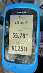
Garmin.jpg

One day was too windy to ride bikes (20+ mph winds), so we hiked a loop thru some more badlands. Here’s a view down the canyon and wash we walked up (Gower Gulch)
Gower Gulch.jpg


and a view as we headed down into Golden Canyon
Golden Cyn.jpg
 
fantastic !! i'll have to get down there for some riding.

the "gravel" looks pretty hard-packed too, not like the stuff we have here which is thick, loose layer of "gravel" big enough that i'd call them rocks.
 
Is that paved road a bike trail? Wondering as we live in Las Vegas and was talking about camping out there .. wanting to bring my telescope to really see out I tot he sky but the bikes would be awesome too
 
Mr. @e-levity: Did you record your ride map? Interested to see it!
Is Zabriskie Point visible on any of the pictures?
 
Last edited:
Mr. @e-levity: Did you record your ride map? Interested to see it!
Is Zabriskie Point visible on any of the pictures?
Oh, you and Michelangelo Antonioni are obsessed by Zabriskie Point! :eek:

For me, what's interesting is that over the years I've spent months hiking in the Sierra but never made it to Death Valley. Then there was the exciting hike up White Mt (14,252 foot/4344 meters) on the Calif/Nev border.

Over the course of about half and hour:

White hail free.jpg


White hail covered.jpg


White - me.jpg


Steps in hail.jpg
 
Zabriskie Point
I'm sure Christian Brevoort Zabriskie's name came from the Polish "Zaborowski" :D

P.S. I was right!
The Zabriskie family descended from Albrycht Zaborowski (Albert Zabriskie), a Polish immigrant from Angerburg (Węgorzewo) in Ducal Prussia, who settled in New Jersey in 1662 alongside a Dutch community. /Wikipedia/
 
That looks like a great time! We were there at Thanksgiving but without bikes. Stayed in Shoshone overnight and next day went sight seeing in the RV. Thanksgiving dinner at the Inn at Furnace Creek. If you haven't read it, Death Valley in 49 is a must read. What tires do you have on your bikes? I am thinking I'd need to change from my smooth street tires for some of those unpaved trails.
 
Great pictures! My wife and I really enjoyed our time there a few years ago, although we did not have bikes and stayed at the Furnace Creek Inn, which is probably a bit more lux than where you stayed (hey, we're old -- what can I say?). :D One of the most interesting places we visited was Scotty's Castle, which I guess was seriously damaged in flash floods (?) a couple years later and has yet to reopen.

Did someone say Zabriskie Point?
IMG_1727.JPG
 
Is that paved road a bike trail? .. wanting to bring my telescope to really see out I tot he sky but the bikes would be awesome too
Artist Drive looks like a wide bike path, but it’s a narrow one-way road. Cars usually drive slowly so it’s pretty safe. And there are pull-outs for them to use if you pass them on the steep curvy downhill sections! Map and an elevation profile of the Drive segment are below. The Artist Drive segment is about 9 miles with 2000+ ft climbing.

Artist Dr map.jpeg

Artist elevation.jpeg

The sky is very clear and dark for star viewing at a new moon. Under a bright full moon you can hike in the badlands.
 
Last edited:
Mr. @e-levity: Did you record your ride map? Interested to see it!
Is Zabriskie Point visible on any of the pictures?
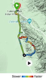
The map below shows a trace of the ride to Dante’s View. (including Zabriski Point just for you!)
Dante map.jpeg


The two hiking photos above were taken a bit below Zabriski Point. Here’s a pic taken slightly higher up a few years ago that shows more what the view from the Point looks like. (Young Mr. @rochrunner just posted a nice photo with a similar view.)
Zabriski view .jpg
 
Last edited:
... What tires do you have on your bikes? I am thinking I'd need to change from my smooth street tires for some of those unpaved trails.
As Stefan noted above mrs levity has 27.5 wheels with 1.9 Gravel King tires. I run Specialized Tracer 700x47 tires on the OEM wheels on my bike. Both roll and grip fine and provide pretty good cushion at 28-30 psi. I’ve also run Specialized Pathfinder Pro 700x42 tires and these are also pretty good all-around tires. You don’t really need much tread for smooth dirt. Lowering air pressure gives the most benefit.
 
Mr. @e-levity:
Your post made me very interested in the Death Valley! I've read a lot to learn more, and found this e-bike related video. Aren't you a Levo owner, too?

Death Valley is especially popular with German tourists for some reason, who like going to Badwater Basin in July when it's 120-130F (48-54C)! There is also a 135 mile ultra-marathon that goes from Badwater Basin (lowest point in the USA) to the top of Mt Whitney (highest point in the lower 48 states). No shortage of crazies around here!
 
Death Valley is especially popular with German tourists for some reason, who like going to Badwater Basin in July when it's 120-130F (48-54C)! There is also a 135 mile ultra-marathon that goes from Badwater Basin (lowest point in the USA) to the top of Mt Whitney (highest point in the lower 48 states). No shortage of crazies around here!
If not the reality of life, I'd like to visit the DV myself at some reasonable season...
 
Stefan if you decide to visit, Fly into Las Vegas and you can stay in my rv for a day or two. Before you head to Death Valley

Might need to unblock me first but the offer still stands.
 
Mr. @Stefan Mikes - Thank you so much for sharing the great EMBN video!

Steve always does a good job of capturing the sense of a ride. The Cerro Gordo road is scenic going up, and can be thrilling going down. Most of the views shown are to the west over the Owens Valley with only the peek from the top to the east toward Death Valley proper.

Like most of the dirt/4x4 roads in DVNP it’s probably the most fun on a dual sport motorcycle. Due to the size of the Park, loop rides end up being 200+ miles. The Park is pretty large, over 13 million square kilometers, and elevations vary from -280 ft to 11,000 ft. There are lots of old mines and ghost tons, mountains and salt flats, canyons and sand dunes to explore.

Here’s of pic of mrs levity riding her TW200 on the road to Cerro Gordo a few years ago. You can see how much it winds upward. It’s impressive that they could establish a large mine in such a high, remote, and desolate place. And then they literally had to “get the lead out”.
Cerro Gordo.jpg


Here’s a shot of mrs levity and little levity on a pass just above Leadville, an abandoned mining town just above Titus Canyon in DVNP, that was also used for lead mining.
Leadville.jpg


If anyone is out this way and wants to explore parts of the Park I can provide some tips for moto, jeep, or bike rides.
 
Death Valley is especially popular with German tourists for some reason, who like going to Badwater Basin in July when it's 120-130F (48-54C)! There is also a 135 mile ultra-marathon that goes from Badwater Basin (lowest point in the USA) to the top of Mt Whitney (highest point in the lower 48 states). No shortage of crazies around here!
While I've never been to Death Valley, I have been to the top of Mt Whitney three times. First time was from the west ending a nine day backpack up there. I slept on top in a stone-walled topless coffin. Folks constructed these to keep out the wind. Just toss your sleeping bag in and instant although still chiily shelter. The next time was as part of doing the south half of the John Muir Trail over two weeks of hiking. The final time and it is probably the final time was from the east side which is a much steeper approach. Each was fantastic. But from Death Valley to the top - not me.

The interesting thing is that Mt Whitney is not the tallest one shown in the video. It is lost among a series similarly sized peaks to the right of the prominent one in the film.
 
Last edited:
Back