2026 - Our Rides in Words, Photos, Maps and Videos

Rab, I'm impressed with the Metric Century you made on an analogue bicycle in your mountains! The chain link... Well, the things do happen. Had a similar situation recently on my big Vado but was able to fix the quick link anyway. (I carry both 11- and 12- quick links for both my e-bikes now).

Waiting until you get your new e-bike (and possibly resolve your Yamaha motor issue)!
 
1000008850.jpg
1000008852.jpg
1000008854.jpg
1000008856.jpg
1000008858.jpg


Riding in three countries in one day, France, Switzerland and Germany. Had some luck with the weather and some good post ride grilling.
 
The ride started at Sadgill, hopelessy cute hamlet
GAT1.jpg


Started very unassumingly, easy gravel ride in lovely weather.
GAT2.jpg


Withinminutes the clouds gathered and the track became seriously steep and loose
GAT3.jpg


Its quite a tourist attraction for offroaders as its a public road, you need a permit for once amonth usage.
GAT4.jpg


This guy was superfit on a manual, but couldnt ride most of the uphill sections
GAT5.jpg


It was first geat turbo all the way with the front end deciding your path
GAT6.jpg


Not too bad, but very tiring, its much steeper than it looks.
GAT7.jpg


It was trying to rain but held off.
GAT8.jpg


This is where we joined the bridleway to basically climb over that mountain in the distance
GAT9.jpg


Everyone told us it was impassable with a bike
GAT10.jpg


It slowly got steeper and steeper and more unridable
GAT11.jpg


Youd have to be a horse stunt rider to make this.
GAT12.jpg


I had become completely exhausted, a passing group told us it was twice as steep and rocky to the top, i was like..its a bridleway, could the horses fly back in the day?
GAT13.jpg


We reluctantly retreated and rode the pass back in the rain, thank god we did.
The slippery rocks made it twice as hard.
GAT14.jpg


Maximum concentration on the descent, once a tyre slid it skipped over two foot.
GAT15.jpg


These guys were chatting about riding a bike over the pass so loud they didnt hear us approach
GAT16.jpg


Rain cleared on the final run out, we stopped talking we were so tired
GAT17.jpg


The road up to Sadgill is like a disneyland ride of beautiful english mountain homes.
Im just mowing the lawn dea...splash.
GAT18.jpg


The roads is 6 inches, '152,400,000 nanometres' wider than the van either side
GAT19.jpg


how could you ever be sad living in this up here.
GAT20.jpg


I think they bought that Landrover just to park it outside the house.

Strangely enough I came back with five bars and brian only two, this is unexplainable, I was in turbo all day.
Either my electronics have gone haywire or Brians battery is failing.
GAT21.jpg
 
Yesterday, I decided to take a shorter ride on the Pinarello and explore some of the roads and beaches on the Outer Cape that I haven't seen.

54 miles, 1155 feet, 3:30, main battery only. I rode mostly in Off, and some in Eco, as I had 75% battery left at the end. I used the predictor beforehand, set to all Eco, and it told me that I would have 17% left. That sounds about right.

A nice shot of the upper Bass River from the rail trail overpass. The navigation bouys have been removed for the season. The terns on the wires are watching for lunch below in the water.

20260916_132508_resized.jpg


The first stop was Skaket Beach in Orleans on the bay side. The snack bar is closed up for the season but there were plenty of beach goers out.

20260916_142123_resized (Custom).jpg


Next stop was Rock Harbor. The old landing and dock system was falling apart, to the point that it could not support commercial fishing anymore. The town spent $9M to completely rebuild it.

20260916_143010_resized.jpg


Too bad they were closed. I could have gone for some beignets. Around the corner from Captain Cass', is the Rock Harbor Grille, one of the nicest seafood restaurants on the Cape.

20260916_142922_resized (Custom).jpg


At the harbor inlet.

20260916_143215_resized (Custom).jpg


After the Rock Harbor stop, I decided to head east over to the ocean side. I jumped back onto the CCRT, crossed Route 6, and then rode the Nauset trail over to Coast Guard Beach. The trail winds through the dunes.

20260916_145611_resized_2 (Custom).jpg


The trail crosses this huge estuary via a wooden boardwalk.

20260916_150130_resized_2 (Custom).jpg


The Coast Guard Station has been turned into an educational center for studying sea life and the coastal environment.

20260916_150414_resized_2 (Custom).jpg


A mile or so up the road from Coast Guard Beach is Nauset Light. This was moved here in the 1800's from what is now the Coast Guard station in Chatham, was fully restored in the 1950's, and is automated today.

20260916_151239_resized_2 (Custom).jpg


My next stops were on the bay side, so I took some back roads over to Thumpertown Beach. While we have tall dunes on the bay side mid-Cape, this is the first bay side beach that I've seen that has a steep dune with stairs down to the beach. This is very common on the ocean side, but not so much on the bay side.

20260916_153054_resized_2 (Custom).jpg


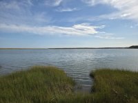
Down the road from Thumpertown Beach is Kingsbury Beach. No tall dunes here. My home is off in the distance about 1.5 miles from the beach.

20260916_154235_resized_2 (Custom).jpg
 

Attachments

  • 20260916_150130_resized_2 (Custom).jpg
    20260916_150130_resized_2 (Custom).jpg
    442.5 KB · Views: 0
Back