View attachment 190926
From Zero to Hero, what a day!
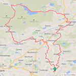
I had a big ride planned for today, around 120 miles with a 32 mile drive to Powmill where I was going to park the car in a layby and cycle up to St Andrews and head back down the east coast! I had everything in the car yesterday except my batteries, with a temp of -2C expected this morning I didn't want to leave my batteries in the car overnight! So all I had to do this morning was put the batteries in the car and go, 30 miles into my drive a shiver ran down my spine when I realised I hadn't brought my batteries!!! My mood changed from total excitement to absolute dread! So I had no choice but to drive home, I got back at 9.25am and knew it was pointless using my car now!
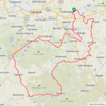
So I quickly came up with a new route from home, the temp was now 5C and expected to rise to a very pleasant 12C and there was very little wind! So after my awful start to the day I was now in my happy place sat on the bike, I made my way down to the Clyde Valley and tackled the big climb up through Hamilton where I joined the back road to Chapelton and grabbed my first photo!
View attachment 190927
From there I made my way to East Kilbride which isn't my favourite place but I worked there for almost 10 years and know all the shortcuts to avoid the worst of the traffic, I made it through without incident and headed for Eaglesham! A 3.5 mile climb up over the moors! Part way up I stopped for some photos, its such a great road and pretty quiet for the most part!
View attachment 190928
View attachment 190929
Lochgoin Reservoir in the background!
View attachment 190930
The climb just keeps going!
View attachment 190931
View attachment 190932
Time for the big descent!
View attachment 190933
At the end of the road I joined the main A77 which is quiet since they built the M77 motorway which runs alongside the old road! I then turned south on the A719 which is one of the best roads in the country and the main reason I chose this alternative route! This certainly put the disappointment of this morning way to the back of my mind, it was proper cycling heaven!
 View attachment 190934
View attachment 190935
View attachment 190934
View attachment 190935
The lambs are growing fast!
View attachment 190936
I had a real blast down the final descent into Galston where I joined the back road to Sornhill, a 2 mile climb and you can see why its called this!
") View attachment 190938
View attachment 190938I stopped for a short break and a snack near the top of the climb and grabbed this photo!
View attachment 190939
Then I continued up the climb and the awesome roads just continued!
View attachment 190940
View attachment 190941
A short time later I arrived in Sorn and stopped on the bridge for a photo before battling up another 2 mile climb!
View attachment 190943
The climb out of Sorn is a real tough one and the road is a proper boneshaker so I was glad to make it up the climb and get back on smooth roads again!
View attachment 190944
I had a nice view of the hills here also, I believe this one is called Cairn Table!
Cairn Table is the highest of the hills which dominate the moorland landscape to the south of Muirkirk, rising 593m above sea level. The hill takes its name from the two large prehistoric cairns which stand on the summit.
View attachment 190945
View attachment 190946
I was now heading east towards Muirkirk and the wind was starting to pick up, only around 15mph though ( a light breeze in these parts) and from the SE which would mean a nice tailwind from Muirkirk to Strathaven! Another amazing road, in my motorbiking days it was a real favourite!
View attachment 190947
View attachment 190948
Glengavel Reservoir!
View attachment 190950
I was nearing Strathaven now but turned east on the back road to Sandford to avoid the busy town, it starts with a climb and is followed by some nice undulations!
View attachment 190951
View attachment 190952
I was approaching Sandford and spotted a quiet side road and decided to check it out, it was a bit rough in places but I enjoyed the little change of scenery! Eventually it brought me out on the road to Kirkmuirhill which was my planned route and I came across more young lambs which were very vocal!
View attachment 190953
From Kirkmuirhill I took the back road through Auchenheath, a big fast descent quickly followed by another big climb and then the awesome descent down into the valley! Then it was another big descent through Hazelbank and on to Crossford with the big climb out of the valley ahead of me!
My last 2 photos on the bridge at Crossford over the River Clyde!
View attachment 190954
View attachment 190955
I had 88 miles in my legs now so I cranked the assist up to
level 3 up the climb, I don't think I would have made it up in eco mode...

I had only covered 8 miles with my 3rd battery so I had lots of juice left to make it up all the climbs into Carluke! The road up past Carluke railway station was closed so I had to follow the diversion which took me out at the far side of the town, from there I took the back road to Allanton and up the big climb to Kirk of Shotts and part way up 100 miles appeared on my gps!
Level 3 assist was a real blessing up this one, near the top of the climb I turned west for Hareshaw which was mostly downhill and wind assisted! It was just amazing and had me grinning from ear to ear!

I then took my usual back roads home and was pretty tired when I got there but absolutely buzzing after a brilliant day on the bike!

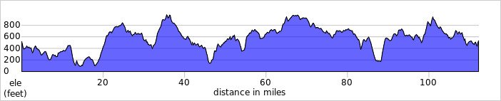
I have now passed 1500 miles, 1528 to be exact and have already climbed 102,719 ft this year from just 20 rides! I think I will sleep for at least 10 hours now...