2024 - Our Rides in Words, Photos, Maps and Videos

He was still in Japan a week or so ago and checking in regularly up to that point. Then nada

Yes, he's posted pics and video from this current trip, but has been a no show for almost a couple of weeks
I've texted him - If he has his phone on roaming he'll get it, and if using a dual setup (travel eSim in his phone, like I do), he may as well.

Otherwise he won't until he returns to Canada.
Art is not really a big "attached to his phone" in my experiences, so he may in fact just be "running quiet" for a while.

It's funny how our minds sometimes are all in alignment.
I'd just noticed he'd not commented on my post when you guys posted about your concerns,
 
Your eyes don't deceive you... blue sky! The first we've seen in a couple of weeks. :D
1731360001877.png


1731357118825.jpeg


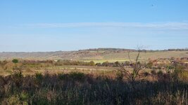
Looking across Dunstable Downs. ☺️

1731357209620.jpeg


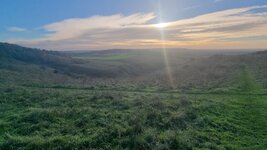
I can't lie... The views are worth it once you get to the top of the hills. :)

1731357277082.jpeg


Steps of doom. Some of these steps are a foot deep, and riding down them is not for beginners! But it's better going down than trying to get up! 😬

1731357305797.jpeg


More views across the Buckinghamshire countryside from the top of Gallows Hill.

1731357436854.jpeg


Ivinghoe Hills ... Loads of hills to explore.

1731357571109.jpeg


Oh great... another hill. :D

1731357481643.jpeg


The most dangerous animal you'll encounter in the British countryside. ;)

1731357624337.jpeg


Aldbury Village... Plenty of old buildings to see.

1731357675611.jpeg

1731357709354.jpeg

1731357724119.jpeg

1731357743777.jpeg

1731357766981.jpeg


Diverted off course to Ashridge Estate for snacks from the cafe.

1731357795737.jpeg


The restoration of the Bridgewater Monument appears to be finished.

1731357876035.jpeg


Cafe at Ashridge. Can I have a Bacon Bap and a Coffee, please? "We've stopped serving hot food for the day". 2.45pm :oops:

1731357908730.jpeg


I might be going mad but as I rode through these woods I'm sure I saw a dog running with 4-5 deer. I wish I caught a photo of it but they ran off quickly.🤣

1731357943671.jpeg


Donkeys!

1731357974950.jpeg


Found a little pub in the outback of nowhere. "Do you do hot food?" YES... woohoo at last.

1731358012167.jpeg


Descent to somewhere...

1731358051430.jpeg


All important village news. They still live in the 1800's around here. ;)

1731358091035.jpeg


More hills because 1 is never enough.

1731358140272.jpeg


View from the top of the hill.

1731358161652.jpeg


Getting dark! Need to get home quickly.o_O

1731358220352.jpeg


I saw this on my ride back. I had no idea it was a school... Bit posh. :D

1731358268448.jpeg
 

Attachments

  • 1731357398029.jpeg
    1731357398029.jpeg
    881 KB · Views: 27
  • 1731357526693.jpeg
    1731357526693.jpeg
    898.3 KB · Views: 25
Last edited:
Your eyes don't deceive you... blue sky! The first we've seen in a couple of weeks. :D
View attachment 185737

View attachment 185690

Looking across Dunstable Downs. ☺️

View attachment 185691

I can't lie... The views are worth it once you get to the top of the hills. :)

View attachment 185692

Steps of doom. Some of these steps are a foot deep, not for the beginners! But it's better going down than trying to get up! 😬

View attachment 185693

More views across the Buckinghamshire countryside from the top of Gallows Hill.

View attachment 185697

Ivinghoe Hills ... Loads of hills to explore.

View attachment 185703

Oh great... another hill. :D

View attachment 185699

The most dangerous animal you'll encounter in the British countryside. ;)

View attachment 185704

Aldridge Village... Plenty of old buildings to see.

View attachment 185706
View attachment 185707
View attachment 185708
View attachment 185709
View attachment 185710

Diverted off course to Ashridge Estate for snacks from the cafe.

View attachment 185711

The restoration of the Bridgewater Monument appears to be finished.

View attachment 185713

Cafe at Ashridge. Can I have a Bacon Bap and a Coffee, please? "We've stopped serving hot food for the day". 2.45pm :oops:

View attachment 185714

I might be going mad but as I rode through these woods I'm sure I saw a dog running with 4-5 deer. I wish I caught a photo of it but they ran off quickly.🤣

View attachment 185715

Donkeys!

View attachment 185716

Found a little pub in the outback of nowhere. "Do you do hot food?" YES... woohoo at last.

View attachment 185718

Decent to somewhere...

View attachment 185719

All important village news. They still live in the 1800's around here. ;)

View attachment 185720

More hills because 1 is never enough.

View attachment 185721

View from the top of the hill.

View attachment 185722

Getting dark! Need to get home quickly.o_O

View attachment 185723

I saw this on my ride back. I had no idea it was a school... Bit posh. :D

View attachment 185724
Gorgeous ride! I see that you're putting your new SL to good use. Impressive that you averaged 219W in this topography. I'm averaging only 150-170W but getting stronger.

I also see from Wikipedia that "downs" — a common landform in southern England — are just hills underlain by chalk. But I'm sure that many have felt just as strongly that these are really "ups".

What's your position on this? Wonder how the downers prevailed?
;^}
 
Last edited:
1731356282481.png


Another gorgeous day for a bike ride, much cooler but with light winds it didn't feel cold at all! My plan was to head for the Forth bridges which is always a great ride when the winds are light! I set off just after 9am with a planned ride of around 70 miles or so, I took the cycle path past Hillend Loch where I stopped for a couple of photos!

1731356580607.jpeg

1731356595891.jpeg

As you can see the water was very calm, its not often you see it like this so it was my lucky day! After passing the loch I joined the main road east to Armadale where I turned north for a few miles and took the back road up to Torphicen! Its quite a climb but nothing an e bike can't handle easily, gradual at first before ramping up!

1731356885336.jpeg

At the top of the climb I took the road up to Beecraigs Country Park, another big climb! I stopped part way up for this photo, it was sure nice to see the sun!

1731357009057.jpeg

I continued up past the park and enjoyed the descent into the valley before turning east towards Kingscavil, the descent here is just sublime before the big climb up to Kingscavil which can be seen in the background!

1731357327073.jpeg

This photo was part way down the descent looking north!

1731357404956.jpeg

At the top of the climb I stopped for photos of the valley below and the country park way up the hill in the background!

1731357484366.jpeg

1731357515916.jpeg

I then decided to take the rollercoaster road at Kingscavil, it plunges down into the valley and ramps straight up again! This descent is a scary one, I almost hit 46mph freewheeling...

1731357641249.jpeg

I then turned east for Winchburgh passing through Bridgend and Threemiletown first! At Winchburgh I turned north for Newton where I got my first proper view of the three bridges over the River Forth, they looked resplendent in the sunshine today!

1731357853716.jpeg

From Newton I continued east towards the bridges and captured this photo of the Queensferry Crossing which is the newest bridge, the structure spans 1.7 miles (2.7km) making it the longest three-tower, cable-stayed bridge in the world.

1731357987439.jpeg

No cycling across this one as its motorway status and not somewhere you would want to ride a bike if you value your life! ;) I then crossed the Forth Road Bridge and stopped for a couple of photos of the iconic rail bridge!

1731358294916.jpeg

1731358313643.jpeg

The Forth eastuary just looked incredible today in the glorious sunshine! After the crossing I continued north into Inverkeithing where I enjoyed lunch before heading west towards Rosyth on the main road for a couple of miles before turning on to the coast road at Limekilns! I grabbed a couple of photos of the Forth passing through the village, the clouds were just spectacular here and they blocked the sun enough to make the photos even better!

1731358660572.jpeg

1731358729728.jpeg

I continued west into Charlestown and headed up the cobbled climb, a real bone shaker on a road bike but only a short climb thankfully! I then turned north and joined the cycle path to Crombie where I joined the main road for a short time before turning on to the coast road down into Torryburn and passed through Newmills, Low Valeyfield and Culross! I continued along the coast road towards the Kincardine Bridge, the road is still in perfect condition after being resurfaced for the World Champs last year!

1731359073101.jpeg

I took the cycle path out to the bridge and after crossing I decided to turn north for Airth instead of heading south for Grangemouth which was my original plan, I was feeling very strong so opted for a longer route which would take me through the City of Stirling! Along the route I had these stunning view of the Ochil Hills!

1731359531581.jpeg

1731359544843.jpeg

I can't imagine the farmer used this antique cultivator on this massive field, it would have taken a year I think!;)

1731359641383.jpeg

I arrived in the city and made my way through without any problems, I know the roads to avoid! ;) I then turned south and decided to tackle the big climb up over the Campsie Hills at Bannockburn, a 4 mile climb to get my heart pumping! After the initial climb there is this short descent before the road really ramps up into the hills!

1731359888857.jpeg

I arrived at the summit and stopped for some photos of Loch Coulter and the road I had just climbed!

1731359951645.jpeg

1731359968059.jpeg

The locals were giving me the eye!😂

1731360001810.jpeg

I then had a short but pretty rough descent into the valley where I turned east to enjoy the 4 mile descent down into Denny, I stopped for a photo of the River Carron which flows along the valley!

1731360174426.jpeg

The descent was just incredible, passing through Fankerton and Stoneywood before arriving in Denny with 73 miles now covered! I needed 89 miles to reach 6000 for the year so I knew at this point that was a certainty, the only problem was my 2 batteries weren't fully charged as I wasn't intending to go so far and I had to change my first battery at 45 miles! I then went into battery conservation mode and headed from Denny to Bonnybridge and I knew I had many big climbs ahead!

From Bonnybridge I turned SW and then east towards Falkirk which involved a lot of climbing and by the time I reached Falkirk I only had 36% left in my 2nd battery with a lot of climbing still to come! Then I remembered I actually switched my first battery at 27% so I changed batteries and and used eco mode up the big climb to Slamannan and surprised myself by reaching Slamannan with 17% remaining! I was fully expecting the battery to die at 20% like it usually does but it got me up the next climb and then suddenly plummeted to 4%!

I switched back to my 2nd battery and made it up the remaining climbs with 28% left, I knew I was going to be fine now as it was mostly flat or downhill until I reached my home town! As I was passing through Plains only a couple of miles from home I just had to stop for a photo of the spectacular red sky, it looked like it was ablaze!

1731361138410.jpeg

A short time later I arrived in my home town with 26% left and 96 miles covered, I just had to make it to 100 miles now so I opted to head home and grab my 3rd battery and do a few loops around town to complete the 100! So I had passed 6000 miles and also passed 50000 miles on my gps since I started using them at the end of 2011!

1731361572085.jpeg

1731361584125.jpeg

What a day that was, never in my wildest dreams did I think I would do 100 miles today! I only need 212 miles now to beat my 6223 miles from 2020, my bike just continues to make me smile everytime I hop aboard! I still remember the day it arrived in 2018 when I attempted to lift it out of the massive box and almost killed myself doing so and thought I had made a big mistake buying a heavy e bike!🤣 How wrong I was...
 

Attachments

  • elevation_profile359.jpg
    elevation_profile359.jpg
    22.4 KB · Views: 17
  • trip-237007897-map-full359.png
    trip-237007897-map-full359.png
    488.1 KB · Views: 18
Gorgeous ride! I see that you're putting your new SL to good use. Impressive that you averaged 219W in this topography. I'm averaging only 150-170W but getting stronger.

I also see from Wikipedia that "downs" — a common landform in southern England — are just hills underlain by chalk. But I'm sure that many have felt just as strongly that these are really "ups". Wonder how the downers prevailed?
;^}
Hi Jeremy, thanks! Yep, the downs are ups! I'm not sure who came up with the idea of naming it that way! :D We don't have any massive hills around this area but enough to poke the interest. I think the biggest hill I've found was 465ft elevation.

I also have to admit this ride was on my Frey EX. I love the SL but it wouldn't be capable of riding some of the terrain I rode today. Although the sun was shining today last night we had rain and in places, the trails/woodland were very slippery and boggy. You need a full-suspension MTB with big knobbly tyres or you'll never make it. I didn't take photos of the most sketchy parts, and to be honest it's hard to portray just how difficult they are to ride in photos!

Tomorrow is my last day off work, so I'm hoping to get a ride in on the SL - although my suspension seatpost arrived today too, so I'll be looking to fit it to the bike. Hopefully, there'll be some daylight left afterwards! :)
 
View attachment 185685

Another gorgeous day for a bike ride, much cooler but with light winds it didn't feel cold at all! My plan was to head for the Forth bridges which is always a great ride when the winds are light! I set off just after 9am with a planned ride of around 70 miles or so, I took the cycle path past Hillend Loch where I stopped for a couple of photos!

View attachment 185686
View attachment 185687
As you can see the water was very calm, its not often you see it like this so it was my lucky day! After passing the loch I joined the main road east to Armadale where I turned north for a few miles and took the back road up to Torphicen! Its quite a climb but nothing an e bike can't handle easily, gradual at first before ramping up!

View attachment 185688
At the top of the climb I took the road up to Beecraigs Country Park, another big climb! I stopped part way up for this photo, it was sure nice to see the sun!

View attachment 185689
I continued up past the park and enjoyed the descent into the valley before turning east towards Kingscavil, the descent here is just sublime before the big climb up to Kingscavil which can be seen in the background!

View attachment 185694
This photo was part way down the descent looking north!

View attachment 185696
At the top of the climb I stopped for photos of the valley below and the country park way up the hill in the background!

View attachment 185700
View attachment 185701
I then decided to take the rollercoaster road at Kingscavil, it plunges down into the valley and ramps straight up again! This descent is a scary one, I almost hit 46mph freewheeling...

View attachment 185705
I then turned east for Winchburgh passing through Bridgend and Threemiletown first! At Winchburgh I turned north for Newton where I got my first proper view of the three bridges over the River Forth, they looked resplendent in the sunshine today!

View attachment 185712
From Newton I continued east towards the bridges and captured this photo of the Queensferry Crossing which is the newest bridge, the structure spans 1.7 miles (2.7km) making it the longest three-tower, cable-stayed bridge in the world.

View attachment 185717
No cycling across this one as its motorway status and not somewhere you would want to ride a bike if you value your life! ;) I then crossed the Forth Road Bridge and stopped for a couple of photos of the iconic rail bridge!

View attachment 185725
View attachment 185726
The Forth eastuary just looked incredible today in the glorious sunshine! After the crossing I continued north into Inverkeithing where I enjoyed lunch before heading west towards Rosyth on the main road for a couple of miles before turning on to the coast road at Limekilns! I grabbed a couple of photos of the Forth passing through the village, the clouds were just spectacular here and they blocked the sun enough to make the photos even better!

View attachment 185727
View attachment 185728
I continued west into Charlestown and headed up the cobbled climb, a real bone shaker on a road bike but only a short climb thankfully! I then turned north and joined the cycle path to Crombie where I joined the main road for a short time before turning on to the coast road down into Torryburn and passed through Newmills, Low Valeyfield and Culross! I continued along the coast road towards the Kincardine Bridge, the road is still in perfect condition after being resurfaced for the World Champs last year!

View attachment 185730
I took the cycle path out to the bridge and after crossing I decided to turn north for Airth instead of heading south for Grangemouth which was my original plan, I was feeling very strong so opted for a longer route which would take me through the City of Stirling! Along the route I had these stunning view of the Ochil Hills!

View attachment 185731
View attachment 185732
I can't imagine the farmer used this antique cultivator on this massive field, it would have taken a year I think!;)

View attachment 185733
I arrived in the city and made my way through without any problems, I know the roads to avoid! ;) I then turned south and decided to tackle the big climb up over the Campsie Hills at Bannockburn, a 4 mile climb to get my heart pumping! After the initial climb there is this short descent before the road really ramps up into the hills!

View attachment 185734
I arrived at the summit and stopped for some photos of Loch Coulter and the road I had just climbed!

View attachment 185735
View attachment 185736
The locals were giving me the eye!😂

View attachment 185738
I then had a short but pretty rough descent into the valley where I turned east to enjoy the 4 mile descent down into Denny, I stopped for a photo of the River Carron which flows along the valley!

View attachment 185740
The descent was just incredible, passing through Fankerton and Stoneywood before arriving in Denny with 73 miles now covered! I needed 89 miles to reach 6000 for the year so I knew at this point that was a certainty, the only problem was my 2 batteries weren't fully charged as I wasn't intending to go so far and I had to change my first battery at 45 miles! I then went into battery conservation mode and headed from Denny to Bonnybridge and I knew I had many big climbs ahead!

From Bonnybridge I turned SW and then east towards Falkirk which involved a lot of climbing and by the time I reached Falkirk I only had 36% left in my 2nd battery with a lot of climbing still to come! Then I remembered I actually switched my first battery at 27% so I changed batteries and and used eco mode up the big climb to Slamannan and surprised myself by reaching Slamannan with 17% remaining! I was fully expecting the battery to die at 20% like it usually does but it got me up the next climb and then suddenly plummeted to 4%!

I switched back to my 2nd battery and made it up the remaining climbs with 28% left, I knew I was going to be fine now as it was mostly flat or downhill until I reached my home town! As I was passing through Plains only a couple of miles from home I just had to stop for a photo of the spectacular red sky, it looked like it was ablaze!

View attachment 185741
A short time later I arrived in my home town with 26% left and 96 miles covered, I just had to make it to 100 miles now so I opted to head home and grab my 3rd battery and do a few loops around town to complete the 100! So I had passed 6000 miles and also passed 50000 miles on my gps since I started using them at the end of 2011!

View attachment 185744
View attachment 185745
What a day that was, never in my wildest dreams did I think I would do 100 miles today! I only need 212 miles now to beat my 6223 miles from 2020, my bike just continues to make me smile everytime I hop aboard! I still remember the day it arrived in 2018 when I attempted to lift it out of the massive box and almost killed myself doing so and thought I had made a big mistake buying a heavy e bike!🤣 How wrong I was...
Incredible ride Rab! The photos look great, and 100 miles and with nearly 6000ft of elevation - and at 16mph average speed is some going! These are numbers I can only aspire too! :D
 
What a day that was, never in my wildest dreams did I think I would do 100 miles today! I only need 212 miles now to beat my 6223 miles from 2020, my bike just continues to make me smile everytime I hop aboard! I still remember the day it arrived in 2018 when I attempted to lift it out of the massive box and almost killed myself doing so and thought I had made a big mistake buying a heavy e bike!🤣 How wrong I was...
You are an improbable person, Rab! Just think I target only 5,000 miles this year despite a warm year!

Heard from Art - all is fine. Heading back to Canada shortly and will return to the forums.
So glad to hear all is good with Art and Sai!

Your eyes don't deceive you... blue sky! The first we've seen in a couple of weeks. :D
I have analyzed your ride Marts using RideWithGPS. I think the terrain would be ridable on a "gravelized" Vado SL. However, RWGPS says the max grade on your ride was 13.1% between Aldbury and Pitstone Common, so I can understand why Frey was your choice! (I still wonder if I could make that trip on my powerful Vado 6.0. I was able to ride this terrain which mostly consisted of gravel roads and only rolling hills but there was a difficult off-road segment around Lake Szurpiły, and a 14% max grade. The route also led through a 11% hill in deep sand!) :)
 
Last edited:
You know, perpetual deep sand at 11% could well be where sinning cyclists go after death. Could that have been a warning shot across your bow?
;^}
Jeremy, I know it is hard to believe but the 520 W peak power, 47 mm Pathfinder Pro, and the 44-46T gearing of my Vado made the climb problem free :D Some female cyclist lost her car-keys on that segment; she called the hot line, the event was broadcast to the riders, and the keys were found!

2025? I'm riding a Giant Trance+ Pro 2 on that race as not to raise suspicions about the max assisted speed of my e-bike. It will be a way better for a violent rocky/muddy singletrack, and also 2.6" tyres, full suspension, and a 520 W motor would give me some edge! :) I say that because the places I was really afraid of were steep descents with sharp cornering on patches of sand!
 
I have analyzed your ride Marts using RideWithGPS. I think the terrain would be ridable on a "gravelized" Vado SL. However, RWGPS says the max grade on your ride was 13.1% between Aldbury and Pitstone Common, so I can understand why Frey was your choice! (I still wonder if I could make that trip on my powerful Vado 6.0. I was able to ride this terrain which mostly consisted of gravel roads and only rolling hills but there was a difficult off-road segment around Lake Szurpiły, and a 14% max grade. The route also led through a 11% hill in deep sand!) :)
Hi Stefan I have to say RideWithGPS is far from telling the full story, the average grade would have been around 13% but this doesn't account for the max grades or the ground conditions. I can tell you my backside was hanging over the back wheel for more than one of these descents. :D I would never advise anyone to try it on an SL or even a big Vado - you could only complete parts of it. You need an MTB to follow my full course... Even on my Frey, there were sections where I had to use Sports Mode Level 5 (1500W peak) with big knobbly tyres and I was still struggling.

The biggest descent found on the ride was over 47%!!

47.PNG
40.PNG

Here are some other gradients... They taper at the bottom and top, but you must consider the "Max" grades or you'll be caught out. It is challenging. The photos don't do it justice, I took photos where it was easy to do so.

25.PNG
17.PNG
16.PNG
19.5.PNG


My Tyres - Michelin E-Wilds 2.8" :)
1731404274732.png
 
Appreciate the kind thoughts and concerns from folks here. The past month has certainly been a fond one to remember and was likely to blame for my absence. I see there’s a lot of catching up to do. Reconnecting and spending time with my wife’s family, relatives and friends I admit had me totally distracted and for good reason. They were such wonderfully warm and accommodating people so much that we are primed for another visit in the spring when the sakura will be in full bloom. We should be home shortly but until then, I’ll leave you with an image of an interesting mountain road in Nagano.

PXL_20241104_030426392.jpg
W
 
1731582374466.png

Here's an interesting map of Poland made by Miguel Valenzuela of Philippines. The map is exaggerated as to the elevation: Poland is a way flatter than shown here. Anyway, you can see how flat the area around Warsaw is! Sudovia (northeast) which is in the infamous 'Suwalki Gap' between Russian Kaliningrad, Lithuania, and Belarus is decidedly hilly but these are steep post-glacial dunes, not real mountains.
 
View attachment 185884
Here's an interesting map of Poland made by Miguel Valenzuela of Philippines. The map is exaggerated as to the elevation: Poland is a way flatter than shown here. Anyway, you can see how flat the area around Warsaw is! Sudovia (northeast) which is in the infamous 'Suwalki Gap' between Russian Kaliningrad, Lithuania, and Belarus is decidedly hilly but these are steep post-glacial dunes, not real mountains.
Beautuful map! Puts your many wonderful ride logs in context.

Vertically exaggerated maps and diagrams are important tools in geoscience and physical geography. Interpretation for scientific purposes can be tricky, but they also bring out key features and relationships that you might never tumble to otherwise — as we see here.

Some, like this map, qualify as works of art. Never tire of poring over them. Earth is a beautiful place.
 
Back