RabH
Well-Known Member
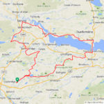
Another gorgeous day for a bike ride, much cooler but with light winds it didn't feel cold at all! My plan was to head for the Forth bridges which is always a great ride when the winds are light! I set off just after 9am with a planned ride of around 70 miles or so, I took the cycle path past Hillend Loch where I stopped for a couple of photos!
As you can see the water was very calm, its not often you see it like this so it was my lucky day! After passing the loch I joined the main road east to Armadale where I turned north for a few miles and took the back road up to Torphicen! Its quite a climb but nothing an e bike can't handle easily, gradual at first before ramping up!
At the top of the climb I took the road up to Beecraigs Country Park, another big climb! I stopped part way up for this photo, it was sure nice to see the sun!
I continued up past the park and enjoyed the descent into the valley before turning east towards Kingscavil, the descent here is just sublime before the big climb up to Kingscavil which can be seen in the background!
This photo was part way down the descent looking north!
At the top of the climb I stopped for photos of the valley below and the country park way up the hill in the background!
I then decided to take the rollercoaster road at Kingscavil, it plunges down into the valley and ramps straight up again! This descent is a scary one, I almost hit 46mph freewheeling...
I then turned east for Winchburgh passing through Bridgend and Threemiletown first! At Winchburgh I turned north for Newton where I got my first proper view of the three bridges over the River Forth, they looked resplendent in the sunshine today!
From Newton I continued east towards the bridges and captured this photo of the Queensferry Crossing which is the newest bridge, the structure spans 1.7 miles (2.7km) making it the longest three-tower, cable-stayed bridge in the world.
No cycling across this one as its motorway status and not somewhere you would want to ride a bike if you value your life!
") I then crossed the Forth Road Bridge and stopped for a couple of photos of the iconic rail bridge!
I then crossed the Forth Road Bridge and stopped for a couple of photos of the iconic rail bridge!The Forth eastuary just looked incredible today in the glorious sunshine! After the crossing I continued north into Inverkeithing where I enjoyed lunch before heading west towards Rosyth on the main road for a couple of miles before turning on to the coast road at Limekilns! I grabbed a couple of photos of the Forth passing through the village, the clouds were just spectacular here and they blocked the sun enough to make the photos even better!
I continued west into Charlestown and headed up the cobbled climb, a real bone shaker on a road bike but only a short climb thankfully! I then turned north and joined the cycle path to Crombie where I joined the main road for a short time before turning on to the coast road down into Torryburn and passed through Newmills, Low Valeyfield and Culross! I continued along the coast road towards the Kincardine Bridge, the road is still in perfect condition after being resurfaced for the World Champs last year!
I took the cycle path out to the bridge and after crossing I decided to turn north for Airth instead of heading south for Grangemouth which was my original plan, I was feeling very strong so opted for a longer route which would take me through the City of Stirling! Along the route I had these stunning view of the Ochil Hills!
I can't imagine the farmer used this antique cultivator on this massive field, it would have taken a year I think!
I arrived in the city and made my way through without any problems, I know the roads to avoid!
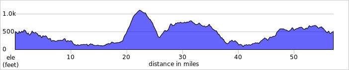
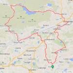
I then turned south and decided to tackle the big climb up over the Campsie Hills at Bannockburn, a 4 mile climb to get my heart pumping! After the initial climb there is this short descent before the road really ramps up into the hills!I arrived at the summit and stopped for some photos of Loch Coulter and the road I had just climbed!
The locals were giving me the eye!

I then had a short but pretty rough descent into the valley where I turned east to enjoy the 4 mile descent down into Denny, I stopped for a photo of the River Carron which flows along the valley!
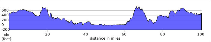
The descent was just incredible, passing through Fankerton and Stoneywood before arriving in Denny with 73 miles now covered! I needed 89 miles to reach 6000 for the year so I knew at this point that was a certainty, the only problem was my 2 batteries weren't fully charged as I wasn't intending to go so far and I had to change my first battery at 45 miles! I then went into battery conservation mode and headed from Denny to Bonnybridge and I knew I had many big climbs ahead!
From Bonnybridge I turned SW and then east towards Falkirk which involved a lot of climbing and by the time I reached Falkirk I only had 36% left in my 2nd battery with a lot of climbing still to come! Then I remembered I actually switched my first battery at 27% so I changed batteries and and used eco mode up the big climb to Slamannan and surprised myself by reaching Slamannan with 17% remaining! I was fully expecting the battery to die at 20% like it usually does but it got me up the next climb and then suddenly plummeted to 4%!
I switched back to my 2nd battery and made it up the remaining climbs with 28% left, I knew I was going to be fine now as it was mostly flat or downhill until I reached my home town! As I was passing through Plains only a couple of miles from home I just had to stop for a photo of the spectacular red sky, it looked like it was ablaze!
A short time later I arrived in my home town with 26% left and 96 miles covered, I just had to make it to 100 miles now so I opted to head home and grab my 3rd battery and do a few loops around town to complete the 100! So I had passed 6000 miles and also passed 50000 miles on my gps since I started using them at the end of 2011!
What a day that was, never in my wildest dreams did I think I would do 100 miles today! I only need 212 miles now to beat my 6223 miles from 2020, my bike just continues to make me smile everytime I hop aboard! I still remember the day it arrived in 2018 when I attempted to lift it out of the massive box and almost killed myself doing so and thought I had made a big mistake buying a heavy e bike!
 How wrong I was...