2023 - Our Rides in Words, Photos, Maps and Videos

I did 16 miles this morning. A picture of an Amish farm with sheep and a horse grazing. I suspect it’s a working horse, most of the Amish horses are. Also a barn that had escaped my camera. I’m had to zoom on with this one as it sits off the road some.
IMG_2199.jpeg
IMG_2200.jpeg
IMG_2201.jpeg
 
Last edited:
It Is Doable To Make 100 km On A Single Battery!
Or, "The Jars All Went For A Holiday" :)

The Jar (Polish: Słoik) is a humorous description of a non-Warsawer living and working in the capital city of Poland only during the working week but leaving the city for weekends. The moniker comes from the fact many of the work-immigrants try to survive the week on the food in jars brought together with them from their families outside Warsaw! On my yesterday ride, I could not quite understand why many dangerous and busy streets of Warsaw seemed to be totally vacated! Then I realised: "It is it not only the weekend, it is also the vacation time! All the Jars must have left!" :)

My friend Makenzen has her knee ruined by a recumbent bike accident. She asked me to come for the chat if I could do it. Well, first I took the "boredom route", or the recommended bike route from my neighbourhood to the Vistula river in central Warsaw (mostly leading via bike paths).

1690170403736.png

P7P Street. In 1893, three engineers and four entrepreneurs uses dowries of their daughters to establish a mechanical company in Warsaw. "Posag Siedmiu Panien, P7P" (Dowry of Seven Maidens) was the first company name, and the trademark. The company later expanded into a huge tractor manufacturer by the name of "Ursus". Now, the former factory has been turned into a housing estate with the main street named P7P (pictured).

1690170860180.png

E-bikes become noticeable in Warsaw. Here, two guys on domestic Kross hub-drive motor e-bikes. (Of course I could overtake them with ease on my Vado 6.0). The picture was taken in the multi-kilometre bike path leading to the heart of the City.

1690171130113.png

I could not take a good picture there. The City of Warsaw is located on a high escarpment. Soon after, there is a very steep descent (with a bike lane) towards the Vistula. The area hosts the Chopin Society, and is famous of the legend of the Golden Duck. (A story of a duck that offered a poor passer-by a fortune on the condition the man spent everything on a single day for own purposes. As he was unable to do it, he gave the rest of the money to a beggar thus breaking the Duck's condition and he became poor again).

1690171760493.png

Meeting My Man :) I usually share Strava Beacon for my long rides so my friends would know where I am. My friend Jerzy was just sipping beer in the housing estate on the right bank of the Vistula and he could notice I was nearby. The meeting was inevitable! :)

1690172048797.png

Danny MacAskill would be glad to ride along that pipe! :D (Even if it does not look so, the pipe is located high!)

1690172263800.png

At a clandestine place (Miedzeszyński Embankment 444). Jerzy knows so much about the area! The owner of the place was a farmer first. Then he tried his luck with a car dealership. Not successful, he opened a bordello there :D As we hear, the site is a private gay club nowadays :)


While I was having coffee at Makenzen's, she asked me: 'You would certainly make a Metric Century today?' to which I replied 'Well, that's only been 34 kilometres so far. I'll have to think how to make the missing distance up!' So I rode southwards.

1690172841884.png

Hungry, I stopped at a Shell petrol station for a hot dog. The sales assistant asked me if I wanted a drink (I said no thank you). When asked for the sauce, I naively chose "Carolina Chili Sauce". Oh! The sauce was as hot as the tears were flowing from my eyes! I rushed back to the station and said to the man: "You were right! Coffee please!" :D

1690173128965.png

My last name is not the most common in Poland but it is not that rare, either :) (A BMW service here).

1690173510358.png

Then I took the Karczew - Gassy ferry to the left bank of the Vistula. The fare is 7 zloties. I usually do not carry cash on me. When I looked into my wallet, it turned out I exactly had seven zloty in coins! How lucky I was!


1690173825332.png

Road #721 is one of the busiest and dangerous roads of the area. Since "all the Jars went for a holiday", I had a unique chance to own the road on last Sunday! Here, in Magdalenka. The location was the scene of the bloodiest battle of gangsters against the Police in 2003. Two top criminals of the Mutant Gang barricaded themselves in a Magdalenka house (using land-mines and heavy weapons) and struggled with the police. Both gangsters were killed but they also killed two and injured as many as seventeen policemen! (Fortunately, those times are over).

1690174555640.png

Yes it is doable to ride for 100 km on a single e-bike battery. The secret is to keep the assistance at 30/30% and consistently pedal hard! :)

1690175374362.png
 
Last edited:
We had a week in April in the New Forest. Weather was a bit variable with heavy rain overnight, but at least it stayed dry for cycling during the day.

A lot of the routes are off-road tracks through Forestry Commission woodlands.

Into the Forest from Burley
Our first ride into Burley Forest, taking in the Canadian War Memorial. We had had quite of bit of rain and the area was well flooded, but at least the tracks were dry.
IMG_0403.jpeg
IMG_0382.jpeg
IMG_0400.jpeg


The Old Railway
Our second ride on a disused railway line from Burley to Brockenhurst
IMG_0427.jpeg
IMG_0419.jpeg


The Butterfly Ride
The third ride was circular route taking in the right hand side of Brockenhurst and Lyndhurst. My brother (Red jacket) joined us that day as he doesn’t live too far away
IMG_0474.jpeg
IMG_0442.jpeg


Godshill, Frogham and Linwood
A hilly ride, mainly on the road.
IMG_0493.jpeg
IMG_0492.jpeg


Beaulieu, Exbury and Lepe
The forth ride was a circular road based ride going from Beaulieu, taking in Calshot and then running along the coast.
IMG_0528.jpeg


Tall Trees Ride
The fifth ride was a circular ride taking in the left hand side of Brockenhurst and Lyndhurst.
IMG_0581.jpeg
IMG_0564.jpeg


DG…
 
1690209460222.png


I was hoping to ride over the Campsie Hills today but luckily I decided to check for roadworks with the Cycling World Championships coming in early August and discovered the road is closed for 10 days for resurfacing works! I can't wait to ride it after the championships are over and it won't be on a weekend as everybody will be having the same idea! ;) 
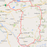
So instead of heading north I picked the Clyde Valley route to the south, heading straight for the quiet back roads and avoiding the main roads as much as possible!

The first 6 miles were all uphill but then I had the awesome downhill to Allanton which I climbed recently, I can tell you its much more fun going down! :D I continued on the back roads to Carluke where I had to join the main road for a mile or so before turning for the Clyde Valley on quiet roads once again! I picked a road I usually climb from Crossford in the valley so I was in for a lovely big descent, this is the start of the big drop! Its very narrow but I had the road all to myself all the way down!

1690210299802.png

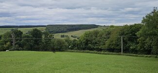
I was going to just fly down the descent without stopping but I just had to stop for photos for you lot!😛

1690210469460.png

As you can see it was very cloudy but no threat of rain thankfully and the temp was just perfect for cycling, the sheep were being very inquisitive while I was taking this photo! They were making quite a racket, letting me know it was their territory...😂

1690210604034.png

One of the garden centres in the valley, very quiet today compared to the weekend!

1690210702631.png

1690210785218.png

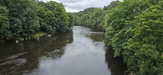
Down in the valley now at Crossford and the River Clyde was pretty high and running fast, no surprise considering all the rain we've had recently!

1690210924354.png

I turned left at the end of the road to take the road through the Clyde Valley to Kirkfieldbank where the climbing would start in earnest again, this is the start of the beast of a climb up to Lanark!

1690211047257.png

Near the top of the climb I stopped for more photos, I love this house near the top just before Lanark and they had the Scottish flag flying high today! As you can see the flag wasn't limp, the wind was starting to pick up from the NW now and I would be heading north most of the way now...

1690211202533.png

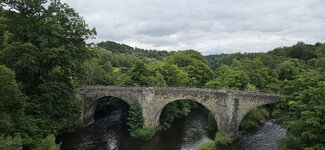
One last picture of the valley before heading into Lanark!

1690211307640.png

Once again I had to use the main road for a bit but I was soon heading north again towards Cleghorn where the railway crossing was beckoning, would I have to stop up the big climb for any trains?

This is the flat part just before the climb started at Cleghorn!

1690211479226.png

The road drops down for a bit though before the climb up over the railway line, as I started the climb I could see a queue of cars so I knew the crossing was closed for trains! At least it meant no cars would be coming down so I could go past all the cars and trucks up the hill and hope the crossing would open before I had to stop...no luck as there were 2 trains passing so I had to stop on the incline! Luckily I only had 3 cars in front now and as soon as the barrier opened I was off up the hill with a load of cars and a few trucks probably cursing at me!🤣

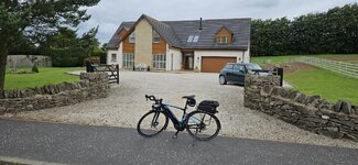
I decided to be a good guy and stopped at the first opportunity to let them all past, I couldn't have picked a better place to stop! What a beautiful home these people have and no doubt the Lamborghini was parked in the garage!;)

1690211936329.png

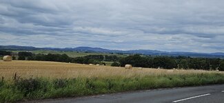
I reached the roundabout at the top of the hill and could have gone straight through towards Forth but I needed a break from the headwind so turned east towards Carstairs and had a nice downhill for a bit! The farmers are in the busy season as you can see!

1690212213198.png

This is the downhill which looks flat here but its a very fast descent!

1690212377908.png

As soon as I could I turned off this road just before Carstairs to get back on the quiet roads, yet more climbing was coming and once again it was right into the headwind! I took another big climb and reached a crossroads where I would usually turn right or left but I thought I would give a new road a try so went straight through not knowing where the road would take me! I did have an idea where it would go but couldn't be sure, it turned out to be a great road with no traffic to be seen anywhere! Eventually I could see a road in the distance which looked familiar and discovered it was the road to Forth that I use all the time, the side road is almost totally hidden from the bigger road!

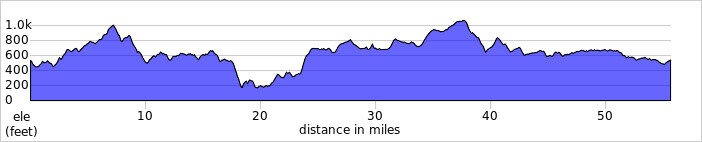
I continued north into Forth and stayed on this road all the way to Whitburn where I turned west towards Harthill before turning north again to Blackridge, all into the headwind but I had lots of battery power left! At Blackridge it was time to head west for home, pretty much a straight flattish road all the way home from here! Another fantastic day on the bike, I really enjoyed this one and although I had almost 33 miles into a headwind with almost 4000ft of climbing I felt really strong today!
 

Attachments

  • elevation_profile179.jpg
    elevation_profile179.jpg
    22.6 KB · Views: 148
  • trip-129096135-map-full179.png
    trip-129096135-map-full179.png
    248.4 KB · Views: 142
  • 20230724_113703.jpg
    20230724_113703.jpg
    410.5 KB · Views: 158
  • 20230724_115015.jpg
    20230724_115015.jpg
    580.1 KB · Views: 158
  • 20230724_120502.jpg
    20230724_120502.jpg
    497.3 KB · Views: 163
  • 20230724_121041.jpg
    20230724_121041.jpg
    625.9 KB · Views: 147
  • 20230724_122649.jpg
    20230724_122649.jpg
    587 KB · Views: 154
  • 20230724_123305.jpg
    20230724_123305.jpg
    347.1 KB · Views: 147
This is not a stream. The rocks are from hurricane Irene, (12 years ago). The stream is normally behind the trees to the right. This is just a flooded field.
8FBE30EA-6098-415E-A59F-5983A92207D5.jpeg


This is normally a trickle in the summer.
3B42438B-1C03-49C1-A353-DE35A71A8487.jpeg


The Lamoille Valley Rail Trail remains closed for assessment and repairs. I had planned to ride the 93 mile long trail, but it’s not looking good for this year. We have had record rains along with flooding.
 
Last edited:
I ride alot. I’m not into metrics or documenting my ride with photos, but last week I turned Strava on. I rode 6 out of 7 days last week. Judging by what Strava is telling me, I’ve climbed several million feet in elevation during the last 21,000 miles. No wonder I’m tired.View attachment 158930
I know these wild figures from GPS trackers are just laughable artifacts, but it still felt good when RideWithGPS reported that I hit Mach 12 on a beach ride.

20230309_190405.jpg
 
I know these wild figures from GPS trackers are just laughable artifacts, but it still felt good when RideWithGPS reported that I hit Mach 12 on a beach ride.
I hate when there is a motor error in my Vado SL, and then Wahoo reports the true max speed but Strava thinks differently!

Recently, Strava has published a newsletter reporting the share of e-bikers in the community (it was pretty high!) and the breakdown by age (no wonder it was mostly senior people riding e-bikes). Hopefully, Strava would add more e-bike related features in near future!

When I see the figure of 12.7 or 25.4 km ridden on my Wahoo, I instantly start wondering how many inches it might be. I took the effort and can tell you now! 25.4 km is one million inches! :D

1690265459234.png

1,000,000 inches to go! :D
 
Last edited:
I did 15 miles today. A couple of times I’ve ridden and started out with light winds and then you pick up a stronger tailwind on the way home. Today it was opposite, almost no wind starting out and then a head wind coming back. I didn’t think to get any pictures so one of my bike in front of my shop.
IMG_2205.jpeg
 
Last edited:
Who’s up for some Surf and Turf?

We’ve never combined two of our favorite pastimes together on one trip before and it’s a wonder why it didn’t occur to us to do this sooner. Pedaling and paddling.

Web capture_24-7-2023_776_connect.garmin.com.jpeg


Web capture_25-7-2023_104946_ridewithgps.com.jpeg

This is where it all began for us 36 years ago. The Kananaskis Lodge is where we first met and worked. It’s changed ownership three times but the memories we have of this place will remain with us for eternity. This trip represents a belated anniversary for us so it was a no brainer to bring the boats and bikes along to reignite some youthful exuberance.

PXL_20230724_144109967.MP.jpg

This would be my wife’s second trip up to the Highwood Pass and third for me. It never gets easier and we both knew that the unrelenting midday heat would reign down upon us without mercy. An hour into the ride and the mercury rose to 36 C.

Web capture_24-7-2023_7459_connect.garmin.com.jpegWeb capture_24-7-2023_740_connect.garmin.com.jpeg

Heading up a climb at the start of the ride. We managed fine without the need for REs on our previous outings up the Pass and we both finished the ride with 38-40% charge remaining on the internals.

GH011053 - frame at 1m15s.jpg

The road surface conditions don’t change much at this elevation as the winter months are particularly brutal on the shoulders. Rumble strips, cracks and fissures don’t leave much room for error especially with vehicles zooming by us at over 120 kph. Hwy 40 is a popular stretch of road for motorcycles and being this was Sunday, they came out in droves.
GH011049 - frame at 0m0s.jpg


These spikes of rosy purple fireweed were nice to see along the otherwise rather mundane roadside.

GH012163 - frame at 0m46s.jpg

Superb views of the surroundings hit you almost every time you look up which makes this road such a wonderful place to cycle.

PXL_20230723_183503196.jpg


Up at the Rock Glacier, we noticed a small campervan parked along the road sporting Euro registration plates on its front and rear. It wasn’t until I arrived home and discovered the van’s Polish origin (WIL - Lipsko County). It appears that it was being driven by one of @Stefan Mikes countrymen/women likely making a coast-to-coast venture. What a life, eh? :cool:👍

PXL_20230723_185545022.jpg

PXL_20230723_185725004.jpg

It’s always a great feeling to reach the summit but we weren’t done yet as we decided to carry on further up the road to the Lineham Day use area.

GH012172 - frame at 0m50s.jpg


Views from the Ptarmigan Cirque rest stop before we pushed further on up the highway.

PXL_20230723_220004030.jpg

PXL_20230723_220020535.jpg

There were not as many roadies out on this day but the few we encountered seemed just as enthusiastic despite the soaring temperatures.

GH012173 - frame at 0m27s.jpg

GH012173 - frame at 0m42s.jpg

GH012175 - frame at 0m34s.jpg


Once we reached our destination at the Lineham Rec Area, the vistas were still in view but the intense heat from the pavement lessened our desire to ride any further.

Lineham.jpg

Lineham looking back.jpg

On the return leg to Highwood, we couldn't resist a last moment decision to snap an obligatory shot.

PXL_20230723_220832500.jpg


Just as we were heading back down the pass, we spotted this fellow on his low slung recumbent as he reached the top. I can't imagine the heat reflection from that down low. Pretty impressive.

PXL_20230723_220820335.jpg

At this point, we would welcome anything remotely resembling even the slightest of a breeze so rocketing down a section of the pass at a top speed of 75 kph was pure bliss.

Descent Highwood.jpg


No kidding.

GH012198 - frame at 1m22s.jpg

PXL_20230723_215013539.jpg

This second group came up on us fast and we had to decelerate abruptly to safely pass by.

Mountain Sheep.jpg


Back at our starting point at the King Creek Trail and a nice reprieve from the blistering heat of the afternoon. We look forward to the second day of our trip which should be much cooler. Stay tuned. :)

GH012198 - frame at 2m38s.jpg
 
Last edited:
Day 2 – Upper Kananaskis Lake (Peter Lougheed Provincial Park)

We never tire of paddling this lake as the vistas are exceptional particularly when seen from the water.

Mornings are the best time to start as winds funneling down from the peaks later in the day can create choppy conditions for the inexperienced paddler. We got off to a rather late start and by the time we launched it was already past 10:30 am. To make matters worse, we were caught off guard by a large grizzly which came lumbering down the beach looking for any morsels that fishing boats could have left behind at the boat ramp. He was about 100 meters from us as we hurriedly rushed to get in our boats. We shouted to others close by as no one seemed to notice except my wife and I. No pics of the bear as this wasn’t a good time to play chicken.

Once on the water, things settled into place and we took in the views of Mts Lyautey and Sarrail.

GH011060 - frame at 0m5s.jpg

GH012200 - frame at 0m15s.jpg


Picturesque Turret Falls. Just as it is on two wheels, you see so much more up close on the water.

GOPR2206.JPG


A great day to be on the water as these paddle boarders were casually making their way along the shoreline.

GH012211 - frame at 0m8s.jpg


A restful place to stop for a snack and take in the views.

PXL_20230724_183246350.jpg

PXL_20230724_183307981.jpg

No time to dawdle as the winds picked up and we decided to head back but managed to sneak in a few more shots of the vistas.

GOPR2220.JPG

GOPR2221.JPG

GH011073 - frame at 1m7s.jpg

GH011073 - frame at 0m0s.jpg

It was an unreal two days of seeing what K-Country has to offer and a stroll down memory lane for the both of us.

Hope to post some video footage of the trip but for the time being we hope that you enjoy the pics.
 
Back