You are using an out of date browser. It may not display this or other websites correctly.
You should upgrade or use an alternative browser.
You should upgrade or use an alternative browser.


christob
Well-Known Member
From my last office commute this past week, before our company mandated everyone telework until further notice. Still riding in the afternoon however!


First pic; sunrise over Four Mile Run stream (that empties into Potomac).
Second pic; weeping style cherry tree on the DC bank of the Potomac River.
First pic; sunrise over Four Mile Run stream (that empties into Potomac).
Second pic; weeping style cherry tree on the DC bank of the Potomac River.
FlatSix911
Well-Known Member
- Region
- USA
- City
- Silicon Valley
Too funny. My condolences on the matching saddle.")
Good catch on the photo... the saddle has been upgraded to WTB.
Maybe he just poses for pictures : Have you actually seen him RidingStefan, you are much more hard core than I. I wait until the temp is approaching 60F before I consider venturing out. You're so bundled up I wonder how you can ride.


Stefan Mikes
Gravel e-biker
- Region
- Europe
- City
- Mazovia, PL
Where is the pic of your bike, @christob?From my last office commute this past week, before our company mandated everyone telework until further notice. Still riding in the afternoon however!
Hahah! A good one, Rick! I promise I will set my camera on a tripod on the next riding day and take some video and photos as a proofMaybe he just poses for pictures : Have you actually seen him Riding
I agree I do look like some Martian in that attire but at least no chance any driver would fail to notice me on the road (unless completely blind) 
Last year I set a goal to ride to Conconully from my house. I would meet up with a friend or two, have burgers and beers, and they would take me and my bike back to my house as I figured the battery wouldn't do a round trip. Then I got the Gazelle.
I feared that the governor of our fair state would soon declare that we must stay at home, so I threw in some trail mix, some extra clothes, some water and took off into the wind. My highest speed with the headwind was 10mph and I think that was on a little downhill. After 6 miles of that, the wind quit and life was much more pleasant.
The elevation of my house is around 900 feet. The elevation of Conconully is 2300 feet and it was 17 miles away. However, it was nicer to ride up the inclines than against the wind oeen the flats. I stopped frequently to sip water. Here are some of the sights along the way. The horses looked to be quite interested in my stop.

One hill conquered, well sort of. I think there were a few feet yet to the crest. You can see what I've come up in the background. I just take my time, often in low gear and try to keep the assist at Tour with an occasional bump up to Sport. Turbo gets used for a short distance at the very start of my ride, where the street is narrow and steep.

I hate going downhill after I've gone up and know that I will need to climb again. That's how the road to Conconully goes. You are rewarded with nice views sometimes. Once again, the eastern edge of the North Cascades is in view. In the background is the final climb before dropping down into Conconully.

I promised friends that I would check in with them when I reached the cemetary. Why there? It used to be the last place a cell phone could get out of. That may have changed because my phone started alerting me to texts when I was down in town. Here is "The Pioneer Cemetary".

And I coasted on into the big metropolis of Conconully. Nothing much was going on. Conconully is a place that used to be a gold mining town and also briefly the county seat. It now relies on tourism. Fishing in the two reservoirs is important to the town and it is trying to get established as a base to ride your ATV out of and up into the mountains. There is a state park on the lower lake, and they have a couple of bathrooms open even though the park is officially still closed.


There is a little park across from the store. You can see the stone in the lower right hand corner in the picture above. It is named Frank Matsura Park. https://en.wikipedia.org/wiki/Frank_S._Matsura Frank Sakai Matsura came to Conconully from Japan in 1901 to work in a hotel kitchen. He ended up setting up a photography studio in Okanogan and photographed daily life in the area. His photos are all over, some are up on the outside walls of businesses. He was well respected by the local folks but died early of tuberculosis. The park has pictures posted around the perimeter of his photos taken in Conconully. I stopped for a bite to eat under the gazebo and made sure to sit in the sun as Conconully was still a bit chilly.

I dreaded riding up the hill out of Conconully, but it was much easier than I thought. I stopped to take a picture of the lower lake, and then pedaled and coasted back down to home. I had to watch my speed because there were a few side gusts of wind that blew me around a bit. I did it, I rode to Conconully and back home, but did not have a burger and beer due to the Corona Virus shut downs. I'll have to do it again when it is permissible to go in and sit down to eat. The whole trip was 35 miles. The cars were polite and there were no mishaps.

I feared that the governor of our fair state would soon declare that we must stay at home, so I threw in some trail mix, some extra clothes, some water and took off into the wind. My highest speed with the headwind was 10mph and I think that was on a little downhill. After 6 miles of that, the wind quit and life was much more pleasant.
The elevation of my house is around 900 feet. The elevation of Conconully is 2300 feet and it was 17 miles away. However, it was nicer to ride up the inclines than against the wind oeen the flats. I stopped frequently to sip water. Here are some of the sights along the way. The horses looked to be quite interested in my stop.
One hill conquered, well sort of. I think there were a few feet yet to the crest. You can see what I've come up in the background. I just take my time, often in low gear and try to keep the assist at Tour with an occasional bump up to Sport. Turbo gets used for a short distance at the very start of my ride, where the street is narrow and steep.
I hate going downhill after I've gone up and know that I will need to climb again. That's how the road to Conconully goes. You are rewarded with nice views sometimes. Once again, the eastern edge of the North Cascades is in view. In the background is the final climb before dropping down into Conconully.
I promised friends that I would check in with them when I reached the cemetary. Why there? It used to be the last place a cell phone could get out of. That may have changed because my phone started alerting me to texts when I was down in town. Here is "The Pioneer Cemetary".
And I coasted on into the big metropolis of Conconully. Nothing much was going on. Conconully is a place that used to be a gold mining town and also briefly the county seat. It now relies on tourism. Fishing in the two reservoirs is important to the town and it is trying to get established as a base to ride your ATV out of and up into the mountains. There is a state park on the lower lake, and they have a couple of bathrooms open even though the park is officially still closed.
There is a little park across from the store. You can see the stone in the lower right hand corner in the picture above. It is named Frank Matsura Park. https://en.wikipedia.org/wiki/Frank_S._Matsura Frank Sakai Matsura came to Conconully from Japan in 1901 to work in a hotel kitchen. He ended up setting up a photography studio in Okanogan and photographed daily life in the area. His photos are all over, some are up on the outside walls of businesses. He was well respected by the local folks but died early of tuberculosis. The park has pictures posted around the perimeter of his photos taken in Conconully. I stopped for a bite to eat under the gazebo and made sure to sit in the sun as Conconully was still a bit chilly.
I dreaded riding up the hill out of Conconully, but it was much easier than I thought. I stopped to take a picture of the lower lake, and then pedaled and coasted back down to home. I had to watch my speed because there were a few side gusts of wind that blew me around a bit. I did it, I rode to Conconully and back home, but did not have a burger and beer due to the Corona Virus shut downs. I'll have to do it again when it is permissible to go in and sit down to eat. The whole trip was 35 miles. The cars were polite and there were no mishaps.
Stefan Mikes
Gravel e-biker
- Region
- Europe
- City
- Mazovia, PL
PDXzap
Well-Known Member
Ditto!!!A nice story, @Cowlitz!
A nice story, @Cowlitz! I can see your Gazelle being a true low-step bike. What is the model, exactly?
Yet another Ortlieb E-Mate. We should make the "Ortlieb E-Mate User Club"
It is a 2019 Gazelle Arroyo Elite. I will admit that my legs and backside are a bit tired today.
D
Deleted member 18083
Guest
We want our apple slices!

Cows are timid, sweet animals that spook easily. Bring some apple slices with you next time and see if you can entice the cow close enough to take a slice.
Coominya, Lockyer Valley, QLD
Spoiler Alert: There was an electric fence between us. Think of it as a safety device like the climbing ropes the schoolchildren were using on the rock face. They're scary things, cows!Stefan Mikes
Gravel e-biker
- Region
- Europe
- City
- Mazovia, PL
The Ozzie ones, perhaps?They're scary things, cows!
christob
Well-Known Member
Mr. Coffee
Well-Known Member
- Region
- USA
- City
- A Demented Corner of the North Cascades
Cloudier weather today. Gunn Ranch Road, WA:


Mr. Coffee
Well-Known Member
- Region
- USA
- City
- A Demented Corner of the North Cascades
Spoiler Alert: There was an electric fence between us. Think of it as a safety device like the climbing ropes the schoolchildren were using on the rock face. They're scary things, cows!
Yes, cows are scary.
Cows kill, on average, about twenty people every year in the United States. Sharks kill, on average, one person every other year. Bears kill about one person per year.
Cow farts are also a potent greenhouse gas. So not only are they murderous, they are Destroying the World.
They are more organized than you think.
steve mercier
Well-Known Member
no CV19 around there!Cloudier weather today. Gunn Ranch Road, WA:
View attachment 48011
View attachment 48013
View attachment 48014
D
Deleted member 18083
Guest
Beyond the seventh cattle grid …

The rail trail runs parallel to the road between the patch of long grass on our right and the cornfield that just visible on the right edge. The rail trail is rough – gravel riders' delight – and the country road is the way you see. In times past, the railway would have been the smooth option and the road indescribably rough, often impassable. I suspect, that over a century ago, the surveyors decreed a two-chain separation of road and rail.
Beyond the fields are trees that are peeping up from the gully through which the Buaraba Creek flows. We'll cross the bridge later, after taking a break in Coominya village which is at the end of this straight. (Be patient; it's a ride in the country.)
Coominya, Lockyer Valley
The inquisitive cows can be seen on the far left, just beyond the ploughed field. This is not really cattle country – no fences – which is how the 'timid' creatures were able to saunter over to the road and beg apple slices. Actually, this photo was taken on the way 'out' and the cows were snapped on the return trip from Coominya village about thirty minutes later.The rail trail runs parallel to the road between the patch of long grass on our right and the cornfield that just visible on the right edge. The rail trail is rough – gravel riders' delight – and the country road is the way you see. In times past, the railway would have been the smooth option and the road indescribably rough, often impassable. I suspect, that over a century ago, the surveyors decreed a two-chain separation of road and rail.
Beyond the fields are trees that are peeping up from the gully through which the Buaraba Creek flows. We'll cross the bridge later, after taking a break in Coominya village which is at the end of this straight. (Be patient; it's a ride in the country.)
Last edited by a moderator:
Readytoride
Well-Known Member
- Region
- USA
- City
- Virginia
The second my phone pinged with the notification that my friend (100 miles south of me) had hopped on her Turbo Vado to begin her bike ride, I knew I better hurry to catch up. I rushed to get my double set of jackets on (temps were mid 40s (F) with a deceptively cold breeze), my drink, get my Bluetooth device, check my electronics, pump the bike tires, say goodbye to my husband three times - each of the three times that I had to rush back inside the house to get something I'd forgotten - and finally, 20 minutes later I was on my LaFree E+1, peddling off to "catch up" with my friend who was now miles ahead of me.
Yeah, we're talking social distance to the max.
My game plan was to take a new route down into the next county south of me, and see if it was something I'd like to add to my list of paved road rides. I was avoiding the gravel roads today simply because most of them had just been graded, and the gravel was too soft for my pleasure. I like a packed gravel road. The grader didn't. He was all about soft and fluffy.
So... south I headed, taking the familiar roads 7 miles until I hit one of the two main east-west highways that intersected our county. It was also the point where I crossed over into the next county, ready to explore.

Now, mind you, Fauquier county had been settled by some very well-to-do families over the centuries, and most of the lands had remained with each generation. One such notable was Paul Mellon. A wonderful, kind, well loved, graciously philanthropic individual. I could elaborate on his background, but thought the historic designation road signs would do a better job and be more fun to read then my blabbing on. (Hint: what they do not say was that the reason he kept his thousands of acres open was more for the local passion of foxhunting in the fall and winter than anything else. Almost all of Fauquier County is vast tracts of open land, thousands of acres, devoted to agricultural/cattle/horse breeding, lands bounded by fence lines resplendent with hunt jumps every hundred feet or so. Foxhunting is life there. They live, breathe, and lust for it. But I digress. Read the signs. I'll shut up for the duration.)

The road I was on was named Rokeby Road, after his farm.

The road was a marvel of simplicity. Flat black with no markings at all. Not smooth, either. As if the road crews had tried to emulate a rolling gravel road in blacktop form.
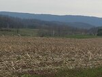
And roll that road did! Up and down and up and down.The down slopes were a blast to bomb along at speed, the upslopes were tackled at the highest assist and lower gears. The down slopes charmed with stone walls, swiftly running sparkling clear creeks, and sweeps of pasture land dotted with horses and cattle. This was my view along the road down slopes:


But the crest of upslopes...ahhhhh! That is where the views awaited. And what views they were! I only had to pedal pedal pedal and then...stop for the views.

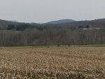
The road took me past Rokeby Farm, a sweeping vista like no other. Well worth a panoramic shot (so to speak - actually two shots, and one's imagination pasting them together)

If you look carefully to the upper right horizon in the picture above, you will see the estate's private airplane landing strip.

It was rather ironic, in this land of pretentious farm/estate signs and gated entryway, that the magnificent acres that comprised Rokeby were announced by a simple little sign staked in the ground. As if the august land needed no introduction, and the sign was a bit of an after thought. I found that immensely amusing.

Everywhere one looked, the signs were obvious that this had been Mellon's lands and roads.


I was surprised to see two other cyclists on the road, both delighted to share a big smile and happy greetings with me as they pedaled past. Despite the crisis enveloping the globe, and the shared fears of the growing pandemic, nothing could sooth the mind and body better than a bike ride in such beautiful, restful surroundings. I was happy to see I wasn't alone in that regard.
Several miles further the road swept to the right, taking me towards the mountains. Here the wind picked up, as did my level of assist. Luckily the road countered the rising wind by sweeping downwards yet again, wiggling between endless fenced cattle fields and old corn fields full of stubble, meandering into deep woodlands, and tiptoing silently past old houses and yet more gated estates.

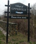
A few miles later the road politely ended, depositing me at the village of Upperville, on an intersection of the main highway where I had started my journey into Fauquier County.

I now had a choice. Go visit Paris, or head home. Decisions, decisions. I consulted my watch for permission to visit Paris - which I hear is lovely this time of year - but was roundly scolded by the timepiece that I was already going to be late getting back home to turn out the horses. Those animals have a very accurate internal clock and expect their "staff" not to be late...at all.
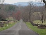
Chastised, and with many sighs of sad resignation, I turned away from the delights of Paris, and headed right, enjoying the two miles through Upplerville on a main highway serenely posted at 25mph. Along the way were several "traffic calming" diversions of road meant to remove a straight line race through this old village and, instead, promote an ease and calmness. It worked its magic, giving motorists time to enjoy the roadside parade of historic houses and fine dining establishments before leaving the village. It also allowed me to relax and ride in traffic without concern.
At the end of the village border, released from the 25 mph restraints, the speed limit jumped to 50mph. However, the road graciously gave me a bit of paved shoulder all to myself, which was greatly appreciated. Traffic passed politely, often slowing and waiting for a passing opportunity if necessary (which wasn't needed because I had my own impromptu bike lane, but some drivers are just extra cautious) and everyone, without exception, passed generously with more than adequate social distance.
About a mile out of town I rode past the famous Upperville Horse Show grounds, the oldest still-in-existance horse show grounds in the US. Equipment and workers were busy sprucing up the extensive show grounds in preparation for...nothing. All shows, races, and events previously planned ... were no longer going to be held. Everything had been cancelled, the first time since World War 1 and 2.
The pandemic was certainly going to go down in the annals of the show's history as the first thing, besides global wars, that has caused the horse shows not to be held.
Just on the border of the show grounds I was greeted with the notification that I was now back in my own county.

It was time to turn onto familiar roads and head home.
I was sad to do so, and would have liked to have gone farther, but my battery, severely depleted by the rolling slopes of the Fauquier County roads and my need for high assist, plus animals impatiently awaiting my now overdue appearance, clinched the deal. Time to put the last of the battery to use and get home, fast.
I arrived home with 26 miles and a whopping 3,094' elevation changes on the GPS, 7 skimpy miles left in the battery, 2 dogs barking with delight at my return, and the loud disapproval of 4 horses in their paddocks demanding my immediate attention to whatever their hearts desired at the moment...which is usually food. No, make that *always* food.
My friend had finished slightly before me, logging 32 miles on her ride, and sharing on Facebook a picture of a lovely magnolia tree in full bloom along her route. She texted me to say it was just as cold when she finished as when she started. It was colder up here, the temps dropping as the afternoon waned.
My stats:
As I'm typing this the rains have moved in, preceded by a bit of sleet. I'm glad I got a ride in as the next day is forecast to be both cold and deluged by torrential rains
Middle of the week the temps will be back up, encouraging another "social distance" ride with my friend. This time I'm going to start on time...and take my extra battery.
Yeah, we're talking social distance to the max.
My game plan was to take a new route down into the next county south of me, and see if it was something I'd like to add to my list of paved road rides. I was avoiding the gravel roads today simply because most of them had just been graded, and the gravel was too soft for my pleasure. I like a packed gravel road. The grader didn't. He was all about soft and fluffy.
So... south I headed, taking the familiar roads 7 miles until I hit one of the two main east-west highways that intersected our county. It was also the point where I crossed over into the next county, ready to explore.
Now, mind you, Fauquier county had been settled by some very well-to-do families over the centuries, and most of the lands had remained with each generation. One such notable was Paul Mellon. A wonderful, kind, well loved, graciously philanthropic individual. I could elaborate on his background, but thought the historic designation road signs would do a better job and be more fun to read then my blabbing on. (Hint: what they do not say was that the reason he kept his thousands of acres open was more for the local passion of foxhunting in the fall and winter than anything else. Almost all of Fauquier County is vast tracts of open land, thousands of acres, devoted to agricultural/cattle/horse breeding, lands bounded by fence lines resplendent with hunt jumps every hundred feet or so. Foxhunting is life there. They live, breathe, and lust for it. But I digress. Read the signs. I'll shut up for the duration.)
The road I was on was named Rokeby Road, after his farm.
The road was a marvel of simplicity. Flat black with no markings at all. Not smooth, either. As if the road crews had tried to emulate a rolling gravel road in blacktop form.
And roll that road did! Up and down and up and down.The down slopes were a blast to bomb along at speed, the upslopes were tackled at the highest assist and lower gears. The down slopes charmed with stone walls, swiftly running sparkling clear creeks, and sweeps of pasture land dotted with horses and cattle. This was my view along the road down slopes:
But the crest of upslopes...ahhhhh! That is where the views awaited. And what views they were! I only had to pedal pedal pedal and then...stop for the views.
The road took me past Rokeby Farm, a sweeping vista like no other. Well worth a panoramic shot (so to speak - actually two shots, and one's imagination pasting them together)
If you look carefully to the upper right horizon in the picture above, you will see the estate's private airplane landing strip.
It was rather ironic, in this land of pretentious farm/estate signs and gated entryway, that the magnificent acres that comprised Rokeby were announced by a simple little sign staked in the ground. As if the august land needed no introduction, and the sign was a bit of an after thought. I found that immensely amusing.
Everywhere one looked, the signs were obvious that this had been Mellon's lands and roads.
I was surprised to see two other cyclists on the road, both delighted to share a big smile and happy greetings with me as they pedaled past. Despite the crisis enveloping the globe, and the shared fears of the growing pandemic, nothing could sooth the mind and body better than a bike ride in such beautiful, restful surroundings. I was happy to see I wasn't alone in that regard.
Several miles further the road swept to the right, taking me towards the mountains. Here the wind picked up, as did my level of assist. Luckily the road countered the rising wind by sweeping downwards yet again, wiggling between endless fenced cattle fields and old corn fields full of stubble, meandering into deep woodlands, and tiptoing silently past old houses and yet more gated estates.
A few miles later the road politely ended, depositing me at the village of Upperville, on an intersection of the main highway where I had started my journey into Fauquier County.
I now had a choice. Go visit Paris, or head home. Decisions, decisions. I consulted my watch for permission to visit Paris - which I hear is lovely this time of year - but was roundly scolded by the timepiece that I was already going to be late getting back home to turn out the horses. Those animals have a very accurate internal clock and expect their "staff" not to be late...at all.
Chastised, and with many sighs of sad resignation, I turned away from the delights of Paris, and headed right, enjoying the two miles through Upplerville on a main highway serenely posted at 25mph. Along the way were several "traffic calming" diversions of road meant to remove a straight line race through this old village and, instead, promote an ease and calmness. It worked its magic, giving motorists time to enjoy the roadside parade of historic houses and fine dining establishments before leaving the village. It also allowed me to relax and ride in traffic without concern.
At the end of the village border, released from the 25 mph restraints, the speed limit jumped to 50mph. However, the road graciously gave me a bit of paved shoulder all to myself, which was greatly appreciated. Traffic passed politely, often slowing and waiting for a passing opportunity if necessary (which wasn't needed because I had my own impromptu bike lane, but some drivers are just extra cautious) and everyone, without exception, passed generously with more than adequate social distance.
About a mile out of town I rode past the famous Upperville Horse Show grounds, the oldest still-in-existance horse show grounds in the US. Equipment and workers were busy sprucing up the extensive show grounds in preparation for...nothing. All shows, races, and events previously planned ... were no longer going to be held. Everything had been cancelled, the first time since World War 1 and 2.
The pandemic was certainly going to go down in the annals of the show's history as the first thing, besides global wars, that has caused the horse shows not to be held.
Just on the border of the show grounds I was greeted with the notification that I was now back in my own county.
It was time to turn onto familiar roads and head home.
I was sad to do so, and would have liked to have gone farther, but my battery, severely depleted by the rolling slopes of the Fauquier County roads and my need for high assist, plus animals impatiently awaiting my now overdue appearance, clinched the deal. Time to put the last of the battery to use and get home, fast.
I arrived home with 26 miles and a whopping 3,094' elevation changes on the GPS, 7 skimpy miles left in the battery, 2 dogs barking with delight at my return, and the loud disapproval of 4 horses in their paddocks demanding my immediate attention to whatever their hearts desired at the moment...which is usually food. No, make that *always* food.
My friend had finished slightly before me, logging 32 miles on her ride, and sharing on Facebook a picture of a lovely magnolia tree in full bloom along her route. She texted me to say it was just as cold when she finished as when she started. It was colder up here, the temps dropping as the afternoon waned.
My stats:
| ELEVATION | |
|---|---|
| GAIN | 3094 ft |
| START | 506 ft |
| MAX | 667 ft |
| SPEED | |
|---|---|
| AVG | 13.8 mph |
| MIN | 0.0 mph |
| MAX | 25.8 mph |
As I'm typing this the rains have moved in, preceded by a bit of sleet. I'm glad I got a ride in as the next day is forecast to be both cold and deluged by torrential rains
Middle of the week the temps will be back up, encouraging another "social distance" ride with my friend. This time I'm going to start on time...and take my extra battery.
Attachments
Last edited:
steve mercier
Well-Known Member
Be safe out there everyone! I stopped to take no pics on my 90 km ride yesterday. Strangely I find the trails are more crowded than the roads now. Wash your hands and keep your distance.

Stefan Mikes
Gravel e-biker
- Region
- Europe
- City
- Mazovia, PL
Good read, Flora! I'm so happy to live in the flatlands so I don't need to negotiate the hills.
Steve, a great picture!
David's stories are delightful!
No riding this week (before the weekend). The "Cold Ivan" has hit Poland.
Steve, a great picture!
David's stories are delightful!
Now you can see!Maybe he just poses for pictures : Have you actually seen him Riding
No riding this week (before the weekend). The "Cold Ivan" has hit Poland.
Last edited:
Good read, Flora! I'm so happy to live in the flatlands so I don't need to negotiate the hills.
Steve, a great picture!
David's stories are delightful!
Now you can see!
No riding this week (before the weekend). The "Cold Ivan" has hit Poland.
LOL I was joking I hope you know :: Hey wait a minute Your face is hidden LOL Jk Hope you didn't make that just for meSimilar threads
- Replies
- 1K
- Views
- 134K
- Replies
- 2
- Views
- 5K