D
Deleted member 18083
Guest
Resting place …

Of course, there was no need to worry after leaving my hilltop break at the Tallegalla Cemetery: downhill with a 40 km/h tailwind gusting to over 60 km/h. Easy, even when back on the plains. Actually, the return saw the Powerfly fly without power. Good fun.
The cloud in the photo was running in the same direction as the range of hills which was at right angles to the wind direction so, I expect, its formation was somehow connected. Long ago, when I was flying light aircraft and, on a few occasions, sailplanes I would have known the answer and been able to rattle off terms like 'adiabatic lapse rate' and 'orographic clouds'. (I still can, but I'm not sure that I'd know what I was talking about!) Suffice it to say that the clouds were 'standing still' despite the wind up there blowing at 50–100 km/h.
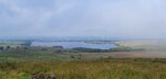
The hills in the distance are about 50 km away and are part of the D'Aguilar Range. Click to link to a ride there.
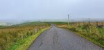
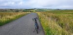
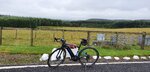
Tallegalla Cemetery
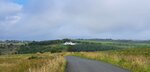
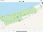
Today was windy and I an eye constantly on my Trek's range prediction. It's disconcerting to arrive at the halfway point with the 'range' decidedly less than the distance home!Of course, there was no need to worry after leaving my hilltop break at the Tallegalla Cemetery: downhill with a 40 km/h tailwind gusting to over 60 km/h. Easy, even when back on the plains. Actually, the return saw the Powerfly fly without power. Good fun.
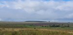
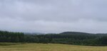
The cloud in the photo was running in the same direction as the range of hills which was at right angles to the wind direction so, I expect, its formation was somehow connected. Long ago, when I was flying light aircraft and, on a few occasions, sailplanes I would have known the answer and been able to rattle off terms like 'adiabatic lapse rate' and 'orographic clouds'. (I still can, but I'm not sure that I'd know what I was talking about!) Suffice it to say that the clouds were 'standing still' despite the wind up there blowing at 50–100 km/h.
The hills in the distance are about 50 km away and are part of the D'Aguilar Range. Click to link to a ride there.
Last edited by a moderator:


")