2020 : Our Rides in Words, Photos & Videos

  • Thread starter Deleted member 18083
  • Start date
Safety Platform (111 years-ago-style) …
2020-08-01-coogarook.jpg

Cooragook Bridge
Brisbane Valley Rail Trail
 
Can't remember... What's your ride, @Chargeride? Amazing video!
If you mean my bike, its a geared hub drive on a 2012 Commencal Supreme DH bike.
I dont have eco/turbo etc.
Just 3 power settings, top being around 700W which is comparable to say the Haibike Flyon.
Its speed restricted by simple gearing...topping out around 20mph on the...yes 24inch rear wheel.
Its built to climb and that extra 2.5mph I get over legal isnt keeping me awake at night, especially in the UK where seeing a policeman is worthy of informing the neighbours.
I know 700W might sound a lot to a newbie but in reality 250W is just a nominal figure and the rules are realy speed restrictions.
The hub puts out 90nm of torque, has its advantages and disadvantages.
 
I know 700W might sound a lot to a newbie but in reality 250W is just a nominal figure and the rules are realy speed restrictions.
Ah, that's a DH bike. 700 W in the rear-hub is adequate. The mid-drive motors for Euro e-MTBs are (as you know) all 250 W nominal, Yamaha/Brose pump up 520-560 W so called "max motor power" but the peak power reaches 700-800 W, so we understand each other.
 
Rode Our fall-back route this morning around the old Seaplane Base because we didn't want to deal with weekend road traffic or join the slow highway procession through Deception Pass to haul the bikes to a trail. Tried to take some different pictures to add some interest 😜.

First leg was out to the end of the spit across the harbor from town. As you can see, we have quite a tide swing - this is low tide:

IMG_20200801_110727002.jpg


At high tide, this slough is actually full of water, and one of our favorite kayak paddles. The route meanders through the marshland, and provides wonderful birding opportunities. It's like being in another world, since, in the kayak, you can't see over the top of the bank:

IMG_20200801_110750167.jpg


Second leg was you through the housing area where we used to live, eons ago when we first came here with the Navy. Our street is still there, but the cute little cottage we lived in was replaced long ago.

From housing, it was down the hill and out along the road beside Crescent Harbor - the next harbor over from our town. The original Navy Seaplane Base was constructed in the point between the two harbors in the WWII era. I rode slow, listening for the telltale sound of a gray whale blowing - we spotted one last weekend while setting crab pots - but all was quiet this morning.

The turnaround point was a field behind another Navy housing area which is covered with wild blackberry bushes. It's nearly " harvest" time, so I sampled a few. Not ready yet, but in another couple of weeks, there will be quite the bounty:

IMG_20200801_115824218.jpg


This is not my favorite surface to ride on, but it's what the Seabees built after the shore road was intentionally breached to restore the saltwater marsh that had been blocked when the road went in decades ago:

IMG_20200801_120504141.jpg


IMG_20200801_120450929.jpg


The marsh, pretty empty here at low tide, really fills up when the tide comes in. There's quite a current ripping through the inlet from the tide, and the bridge supports are constantly needing to be reinforced.

IMG_20200801_120521969.jpg


Nice ride to begin the month!

IMG_20200801_111116145.jpg


Screenshot_20200801-122001.png
 
Ways to cross a dry creek …
  • Just do it! Spend the equivalent of US$3 million on restoration (and wait to be told how the money could have been better allocated):
2020-08-01-093624-2400-gb10.jpg

Lockyer Creek Trestle Bridge
  • Just leave it but put up a barrier and a Keep Off sign:
2020-08-01-110032-2400-gb10.jpg

Cooragook Trestle Bridge
Locations on map above (post #2208)
 
Ways to cross a dry creek …
  • Just do it! Spend the equivalent of US$3 million on restoration (and wait to be told how the money could have been better allocated):
View attachment 60929Lockyer Creek Trestle Bridge
  • Just leave it but put up a barrier and a Keep Off sign:
View attachment 60927Cooragook Trestle Bridge Locations on map above (post #2208)

Beautiful photos!
 
I woke to some rain this morning but I wasn't letting that stop me, luckily by the time I went out it was only spitting and soon stopped! Lovely quiet roads today, I just love riding on a Sunday! :D I did get caught in a heavy shower but managed to shelter under a convenient tree!;) A good start to August, if I get anywhere near my July total I will be very happy but I could be going back to work soon so who knows! I will keep enjoying these rides until I am summoned back to the real world!;)

1596386053749.png
 

Attachments

  • elevation_profile178.jpg
    elevation_profile178.jpg
    22.2 KB · Views: 347
  • trip-53569306-map-full91.png
    trip-53569306-map-full91.png
    444 KB · Views: 341
  • 20200802_090910.jpg
    20200802_090910.jpg
    155.1 KB · Views: 323
  • 20200802_091100.jpg
    20200802_091100.jpg
    806.4 KB · Views: 340
  • 20200802_092153.jpg
    20200802_092153.jpg
    519.4 KB · Views: 323
  • 20200802_092205.jpg
    20200802_092205.jpg
    448.6 KB · Views: 348
  • 20200802_092230.jpg
    20200802_092230.jpg
    828.4 KB · Views: 343
  • 20200802_092253.jpg
    20200802_092253.jpg
    726.7 KB · Views: 349
  • 20200802_101944.jpg
    20200802_101944.jpg
    624.3 KB · Views: 346
  • 20200802_101954.jpg
    20200802_101954.jpg
    265.8 KB · Views: 330
  • 20200802_101958.jpg
    20200802_101958.jpg
    271.9 KB · Views: 339
  • 20200802_102011.jpg
    20200802_102011.jpg
    751.6 KB · Views: 327
  • 20200802_103645.jpg
    20200802_103645.jpg
    602.5 KB · Views: 339
  • 20200802_103658.jpg
    20200802_103658.jpg
    651.8 KB · Views: 351
Although the sky looked like imminent rain this morning, radar showed otherwise, so I decided to take my normal ride around the lake. The highlight was this fawn, who was standing on the opposite side of the road. I stopped directly opposite him at a distance of about 16 feet. He stayed put until I reached for my phone. Then he sprinted to the edge of the woods and stopped. I inched forward and got a decent picture, all the while talking to him.
300379A7-E9FA-4AD5-A04D-D102C448DF56.jpeg
 
A Pleasure Ride In Masuria (not Warmia) or, "Go Ahead, No Worries, There Be Wild Boars!" :D

History section, you may skip it


I need to start with some history. The land northward of Mazovia, along the Baltic Sea, and including today's Latvia, Estonia, Lithuania, and the Russian enclave of Kaliningrad (Królewiec, Königsberg) was populated by Baltic pagans (especially by the native or Old Prussians) in Middle Ages. That was the era of Crusades. That wretched Konrad I, Duke of Mazovia invited the German military Teutonic Order to help him fight the pagans in 1226, despite of the fact the Teutons had rather spotted reputation and were kicked out from Jerusalem and Hungary before. The Teutons fell in love with the land of lakes and forests. They colonised it, civilised it, exterminated the native population or made slaves out of them, and created a regional superpower state. They have always been enemies of Poland.

1596451183678.png

Teutonic Order State at the height of their power (by 1411).

After two hundred years, the military monastic state became an obsolete concept, especially as the role of the townspeople, or bourgeoisie increased. Newly created Union of Poland and (baptised) Lithuania was able to break the Teutonic power in the great battle of Grunwald/Tannenberg in 1410. The Prussian cities also mutinied against the Teutons (the process took more than 100 years). Since those already were the times of Reformation, a political genius, the last Grand Master of the Teutonic Order, one Albert (of the von Hohenzollern) ostensibly surrendered to Poland in 1525, and created a Lutheran state of Ducal Prussia. The remaining Teutonic domain along the River Vistula fell to the Crown of Poland as the Royal Prussia.

Oh, that was a long one. The Royal Prussia became Catholic Warmia (Var-myah - with rolling "r") while the Polish part of the (Protestant) Ducal Prussia is Masuria today. Both Masuria and Warmia are now in one large Warmian-Masurian voivoidship, and it made me very confused on my Sunday's ride...

1596435480393.png

The Teutonic Castle of Nidzica (1370-1409). It is so huge (especially with the limited space inside its outer wall) that it is impossible to take a good picture without a professional camera/lens. (I took that photo by the end of my ride).

In Masuria, not Warmia

It was a long morning Sunday driving to Nidzica (Nibork, Neidenburg) in Masuria because the Hwy #7 is under the reconstruction. It takes two and half hour to cover the distance of 165 km (around 100 mi) but it was worthwhile. And there was what I call "perfect cycling weather" on the ride (@RabH might disagree...) :) 
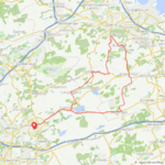
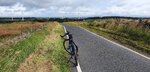
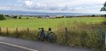
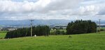
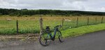
Nothing to complain about! Just to put the summary in advance: I rode for 87 km over pleasant rolling hills of Masuria.

"Go Ahead, No Worries, There Be Wild Boars!" or, My University Freshman Work-Camp Story

In 1980 (I was 19 at that time), I was admitted as a freshman to the Warsaw Technical University. The first thing to do was to spend some 3 weeks at a work-camp in September. We were paid dimes but the idea behind the work-camp was to integrate the fresh students. We went to Zimna Woda (Cold Water) in Masuria.

1596437014323.png

We all, boys and girls were living in that house (which looked far better 40 years ago anyway).

1596437475389.png

We were working with spades to prepare the soil for forest nurseries, similar to one seen in the photo. It was very light work. Once (on Sunday), a local farmer came to us and offered a job: digging potatoes. We took the offer with pleasure, especially as the man paid us handsomely for the work. During the lunch time, he brought true countryside food for us, more, it was served in the quaint way. And he brought beer, too. It was the first (and last) wheat ale I could taste in many years!


1596438085920.png

Poland is rich with bilberry. As I was explained, the bilberry is the European kind, while what is grown in Canada is called "wild blueberry". Right or wrong?

1596438436275.png

My sentimental journey made me ride for several kilometres to the village of Wały (Walls), at the end of civilisation. Masuria sports one of the nicest kind of bus shelters I could see in Poland so far. There, I had a long talk with a woman who must have already been in her 40's when I was a young man. We were chatting about them good olden days, the locals, etc.

1596438879348.png

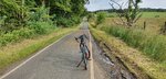
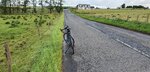
"No off-road today, please!" :D

1596439375000.png

We needed to walk for 4 km each way to get to Wały from Zimna Woda. Believe or not, Wały had the only general store in the whole area, and it was located in that very wooden house! It was owned by Mrs. Mackowa who still lives there. No general store anymore, and the nearest one is in quite distant Napiwoda. The area is totally secluded... Some people long for such seclusion. Decidedly no tourists around! ;)

1596440012590.png

The World's End (one of them). No civilisation past this point! Hardly any roads are plotted on the maps. Reason? The big area once belonged to the military, and a large training range was located there in the forest. I was there again, back in 1987 (age of 26) as an Officer Cadet. I was staying in that area in a large tent to learn my daughter Magda was born!


Anecdote

When we freshmen were working in the forest near the place shown, a tourist appeared. He asked if he could get to the village of Muszaki that way. Our foreman, Stanisław (a local) cheered him up, merrily shouting:

-- Go ahead! No worries! There be wild boars!
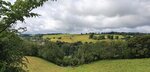
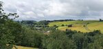
 :D

The Lakeland

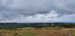
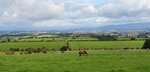
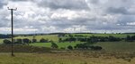
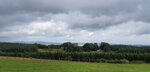
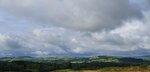
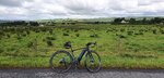
Masuria is the Poland's lakeland, called by travelling agencies "The Land of One Thousand Lakes". In all the honesty, Sweden must have at least three thousand of them... but there is nothing wrong with Masuria. It is a beautiful region, especially in the summer.

1596441471985.png

There was a car in Zimna Woda, in which a man was measuring the road traffic density. He was a local, and he told me: "Why don't you ride to the lake? It is so close..." He changed my way of thinking. Instead of riding the planned route, I went on a pleasure ride... Yes, the Vado could do fire-roads perfectly!

At the Trzcinowe (Reed) Lake. I took a rare opportunity to take a swim in the lake! I'm always forgetting to take swimming trunks on my rides... There was an elderly couple taking sunbath at a small, secluded pier at the lake. I asked them not to watch while I was swimming naked there :) Luckily, there were no minors around! What a pleasure... The water was crystal-clean with them little fish and very warm... (I'll spare you pictures of mine) :D

1596442108079.png

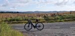
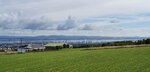
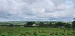
At Omulew, one of the Great Masurian Lakes.

1596442424259.png

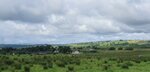
Aeons ago, a glacier carved the lakes and rolling hills of Masuria.

1596442588232.png

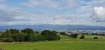
At Lake Dłużek. I was spending holiday together with my Dad there when I was a young kid. We were kayaking, and else. Memories, memories!


1596443194446.png

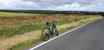
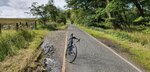
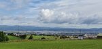
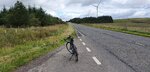
On my return way. Only 28 km left to Nidzica!

1596443352185.png

You are only allowed to stop your car at the "forest parking lots" in the afforested areas in Poland. I replaced the battery there and could enjoy a Turbo ride back to Nidzica.

1596449019711.png

The taste of the few bilberries I ate in Zimna Woda was haunting me. Normally, I don't stop at road-side pedlars of fruit and fungi (because I have no way of transport these on my bike unscathed) but when I saw a young girl selling bilberries near to Napiwoda, I had to stop! "Oh, sir, it had to be a long trip? I seem to see you in the morning at the road?" -- "Indeed!" -- "How long the trip has been?" -- "I expect it would be over 80 km back in Nidzica" -- "That's a lot! I'm experiencing trouble to ride just for 6 km on my bike!" -- "Well, I'm electrically supported, making riding easier" -- "Right, still I admire you!" ;) She was selling bilberries by glass jars. A large jar was PLN15 (less than US$4). I found space in my pannier! And started eating the fruit already in Napiwoda. When I reached home, only a third of the jar was left :D (Diabetes or no diabetes, I don't care!)

1596449524006.png

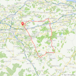
I have been to the less frequented part of Masuria. The time for the main Great Masurian Lakes ride will come!

1596452180435.png

A general map of Masurian Lakeland. Drawing the limits is hard, as regional borders are complex (outcome of the history). Note: A great part of these lands (including the Russian enclave) belonged to German East Prussia until 1945.

1596452381469.png

Nidzica within Europe.
 
Last edited:
Loving your photographs. Curious about the windmills - do you notice their sound?
They can be pretty loud when they are spinning quickly, you can still hear them when they are spinning slowly but its not as pronounced!

@Stefan Mikes Amazing ride and story once again, 27C isn't so bad! :p

1596453871170.png


Another nice ride today despite getting caught in a heavy rain shower again (forecast said it would be dry with light winds:rolleyes:) but it wasn't so bad, I wasn't dripping wet so that's a bonus!;) I suppose winds of 15-20mph can be considered light after the 30-40mph winds we have encountered recently!:p

I have passed some local roads many times thinking I might try that road one day but for some reason just kept bypassing them, so today I got adventurous and decided to try them out, I wasn't disappointed!:D The first one went without a hitch and was uphill all the way which I don't mind on a bike that loves hills, I will enjoy going down this one day!:D This was the view from near the top!

1596454380772.jpeg


The second road was a little different, it starts with a big downhill and of course just as I enter the road and I'm starting to build speed 2 tipper trucks appeared round the bend at the bottom of the hill and being a single track road they were taking up the whole road, time to step aside!;)From all of the recent rain the road had a lot of gravel down the centre, see below! So I had to be careful and continued with caution, of course once I was in the valley it was only going one way...UP!🤣 
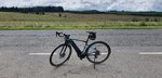
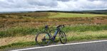
Time to get into the small ring, thankfully all the way up I didn't meet any traffic!
1596454547717.jpeg
 

Attachments

  • elevation_profile179.jpg
    elevation_profile179.jpg
    21.4 KB · Views: 306
  • trip-53630530-map-full92.png
    trip-53630530-map-full92.png
    421.3 KB · Views: 341
  • 20200803_090528.jpg
    20200803_090528.jpg
    588.8 KB · Views: 313
  • 20200803_090720.jpg
    20200803_090720.jpg
    699.2 KB · Views: 333
  • 20200803_090730.jpg
    20200803_090730.jpg
    691.7 KB · Views: 322
  • 20200803_090746.jpg
    20200803_090746.jpg
    720.5 KB · Views: 314
  • 20200803_090809.jpg
    20200803_090809.jpg
    273.7 KB · Views: 346
  • 20200803_090950.jpg
    20200803_090950.jpg
    793.4 KB · Views: 324
  • 20200803_091005.jpg
    20200803_091005.jpg
    781.9 KB · Views: 324
  • 20200803_093030.jpg
    20200803_093030.jpg
    538.2 KB · Views: 325
  • 20200803_093043.jpg
    20200803_093043.jpg
    344.6 KB · Views: 321
  • 20200803_093046.jpg
    20200803_093046.jpg
    295.5 KB · Views: 300
  • 20200803_093049.jpg
    20200803_093049.jpg
    327.8 KB · Views: 309
  • 20200803_094706.jpg
    20200803_094706.jpg
    365.7 KB · Views: 308
  • 20200803_094709.jpg
    20200803_094709.jpg
    374.1 KB · Views: 326
  • 20200803_100012.jpg
    20200803_100012.jpg
    714.1 KB · Views: 301
  • 20200803_100023.jpg
    20200803_100023.jpg
    307.1 KB · Views: 310
  • 20200803_101436.jpg
    20200803_101436.jpg
    244.4 KB · Views: 313
  • 20200803_101501.jpg
    20200803_101501.jpg
    557.6 KB · Views: 304
Back