haven't done one of these rides outside the city in quite a while. it was really nice to get out there, even if i a little bittersweet that i used to do these roads faster and without a motor

the route. about 48 miles and 4,000 feet. it was a calm, perfect morning, warm in the sun and a little cool in the shade.
View attachment 211135
we start near the sleepy town of ross, median home price $4,000,000.
View attachment 211109
after a quick roll through san anselmo and fairfax, we start going up the first climb, around 600 feet. later in the day this climb can get brutally hot, no issues today.
View attachment 211110
at the top of this one, ready for a long gradual descent towards one of my favorite roads ever.
View attachment 211112
things have fully dried out here, in "golden" state mode.
View attachment 211113
classic northern california scenery.
View attachment 211114
before entering the forest, a quick stop to finish my gatorade.
View attachment 211115
sir francis drake road through samuel taylor park is one of the nicest places you can ride a bike, flowy, smooth, surrounded by redwoods.
View attachment 211116
a little cool, and no traffic.
View attachment 211117
once you pop out, around 5 miles later, there's a short steep-ish climb into the open coastal landscape.
View attachment 211118
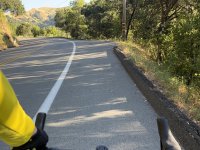
and after dropping down past the tiny town of olema, i turned south to take CA route 1 towards stinson beach. this is one of my least favorite stretches of road, some nice live oaks but annoying rollers that are sometimes a little too steep on the up, and the occasional misbehaved motorist.
View attachment 211119
but we're at the end of this section, about to turn left and go up over those hills.
View attachment 211120
quick break.
View attachment 211121
looks more comfortable than it would be.,
View attachment 211122
time to climb. about a 1500 foot climb in a bit over 4 miles, it's rarely steeper than 10%, but lots of 8% sections and few if any flat spots.
View attachment 211123
i really like this "climbing" screen in my ride app, gives you a clear idea how much longer you've got, how relatively steep the part you're on and about to on is, and so on.
View attachment 211125
still going!
View attachment 211124
and made it to the top for a quick break back under the redwoods.
View attachment 211126
i think about 50000000 cyclists have taken this picture
View attachment 211127
no photos of the descent, because it's steep, windy, a little rough, and would be totally unsafe to take a hand off the hoods. but at the midway point down, have to stop and admire alpine lake on a glassy day.
View attachment 211128
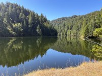
water levels are good.
View attachment 211129
couldn't really capture the odd sensation of looking over the edge at the low side of the dam / spillway.
View attachment 211130
looking back where we came, can confirm the sign.
View attachment 211131
but now we're going back up, and after a few miles we can see where we were.
View attachment 211133
and after some more windy descending, including a few incredibly fun smooth flowy fast sections, a quick stop for a soda. i am pretty sure putting a diet dr pepper in your cage is not UCI approved.
View attachment 211134
it was a really nice ride. i took it very easy for the most part, averaging a little over 15mph and with the bike doing about 30% of the work of the whole ride. use around two thirds of the battery.


 America has even discovered good coffee!