Jeremy McCreary
Bought it anyway
- Region
- USA
- City
- Carlsbad, CA
Would love some help figuring out a Specialized app (SA) problem first encountered today after 3,500 mi of use.

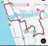
This morning's 17 mi lagoon loop, here perfectly recorded, profiled, and mapped by my handlebar-mounted Wahoo ACE and its phone app.

The SA running concurretly in my pocket also recorded and profiled the ride correctly. But oddly, it somehow failed to extend the red route trace beyond our last stop. Even though it clearly had the data to complete the ride profile perfectly.

SA's red route trace ends exactly where I took this shot of the east end of the Batiquitos Lagoon, wetland, and floodplain. Never touched the SA there, just the camera.
No idea what SA was mapping in real time after that, as it was in my jersey the whole ride. The Wahoo provides all handlebar GPS and mapping services.

Sent the SA's .FIT file to RideWithGPS for display and analysis only. And once again, complete profile, truncated map trace. In this case, RideWithGPS only knew what SA told it about the ride and made exactly the same mapping mistake.
Thoughts? Thanks!
Why record with both Wahoo and SA?
Easy. Much prefer the way SA records, displays, and analyzes bike-specific data like rider power, motor power, and cadence. But I keep my phone off the bars to avoid camera damage. The Wahoo is made to withstand handlebar vibrations and provides better GPS and mapping services at the handlebar anyway.
May seem clunky to use both this way, but it checks all my boxes, and I'm happy with it. Until today, the SA did its part perfectly.
This morning's 17 mi lagoon loop, here perfectly recorded, profiled, and mapped by my handlebar-mounted Wahoo ACE and its phone app.
The SA running concurretly in my pocket also recorded and profiled the ride correctly. But oddly, it somehow failed to extend the red route trace beyond our last stop. Even though it clearly had the data to complete the ride profile perfectly.
SA's red route trace ends exactly where I took this shot of the east end of the Batiquitos Lagoon, wetland, and floodplain. Never touched the SA there, just the camera.
No idea what SA was mapping in real time after that, as it was in my jersey the whole ride. The Wahoo provides all handlebar GPS and mapping services.
Sent the SA's .FIT file to RideWithGPS for display and analysis only. And once again, complete profile, truncated map trace. In this case, RideWithGPS only knew what SA told it about the ride and made exactly the same mapping mistake.
Thoughts? Thanks!
Why record with both Wahoo and SA?
Easy. Much prefer the way SA records, displays, and analyzes bike-specific data like rider power, motor power, and cadence. But I keep my phone off the bars to avoid camera damage. The Wahoo is made to withstand handlebar vibrations and provides better GPS and mapping services at the handlebar anyway.
May seem clunky to use both this way, but it checks all my boxes, and I'm happy with it. Until today, the SA did its part perfectly.
Attachments
Last edited:


 m v
m v