2025 - Our Rides in Words, Photos, Maps and Videos

1762283483486.png


I had one of those rare almost perfect days on the bike, everything just clicked and I had a blast from start to finish! :D 
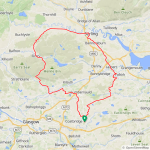
After a really cold spell our weather has changed to mild and wild, thankfully today was just mild with a 20mph southerly breeze blowing! My plan was to head north and climb over the Campsie Hills, I had this view of the Campsies after just a few miles!

1762283702585.jpeg

1762283721669.jpeg

The road down to Cumbernauld is just incredible and with a 20mph wind at my back it was a very quick one, this set the tone for the day! From Cumbernauld I headed west towards Twechar, this road was closed for a while and I was hoping it would have new tarmac laid and I wasn't disappointed! It was super smooth and the final descent down over the canal was a total blast!

1762283993863.jpeg

Another mile or so I stopped for another photo of the canal near Kirkintilloch!

1762284038432.jpeg

From Kirkintilloch I headed north for Milton of Campsie and then west towards Lennoxtown in the foothills of the Campsies! From here I made my way north up the 3 mile climb with the wind helping me, I stopped part way up for this photo of the valley below!

1762284243365.jpeg

I was looking forward to the descent now and managed 42mph down into the valley, I stopped for a few photos on the way down!

1762284285807.jpeg

1762284338446.jpeg

1762284353622.jpeg

1762284365482.jpeg

1762284376646.jpeg

The descent was just incredible and soon it would be time to climb again just after arriving in Fintry! I headed north towards Kippen, its mostly smooth tarmac and very twisty and nothing too steep!

1762284601123.jpeg

1762284611924.jpeg

At the top of the climb I stopped at Loch Kameron for this photo!

1762284658726.jpeg

I had an amazing view of the mountains to the north also!

1762284723141.jpeg

1762284735459.jpeg

1762284747357.jpeg

Now I had the awesome descent down through Kippen to enjoy!

1762284781521.jpeg

1762284794782.jpeg

1762284808176.jpeg

1762284822713.jpeg

I stopped in Kippen for a break and a snack and grabbed this photo before continuing down the amazing descent!

1762284869086.jpeg

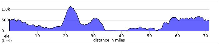
Down in the valley I had my first flat road of the day, east towards Stirling on the A811 which isn't the best road for a bike due to the traffic but I was flying along and the drivers gave me lots of room! After 8 miles on the busy road I arrived in the city of Striling and it was now time to face a 20mph headwind all the way home pretty much as I turned south! I had covered 42 miles at this point and a good chunk of it was a tailwind so no complaints from me...;) My first battery which is now 7.5 years old lasted for 45 miles and I only had about 26 miles to go when I switched to my second battery, so I had the luxury of an almost full battery and made the most of it and laughed at the headwind! ;)

I had this view of the Ochil Hills near Stirling!

1762286258450.jpeg

I started my ride just before midday so I had to be careful and make sure I got home before dark so from Stirling I headed straight for Falkirk on the A9 and stuck to the main road all the way, then it was time to start the serious climbing up to Slamannan! Level 3 assist made short work of that, I don't use it very often and I sure enjoyed it! :D

I stopped for a couple of photos at the top of the climb looking north at the Ochils!

1762286922224.jpeg

1762286934241.jpeg

From Slamannan I headed west for home and the sun was now going down fast with 10 miles remaining, as I headed over the back roads to home I was blessed with this spectacular view to the west!

1762287078483.jpeg

1762287091274.jpeg

I arrived home just before darkness fell and just had enough time to wash my very filthy bike, it wasn't that bad until a mile from home where I came across a mud covered back road! I was on such a high after a brilliant day on the bike that it didn't even phase me, it was just incredible from start to finish! 😁
 

Attachments

  • elevation_profile447.jpg
    elevation_profile447.jpg
    20.1 KB · Views: 9
  • trip-348557110-map-full447.png
    trip-348557110-map-full447.png
    602.8 KB · Views: 11
It's a pity guys you cannot join us in Pilawa on this Saturday!


Translated:
[You talked me into it!] Korboloza Vilgoza on Saturday, 8 November 2025, at 10:00 a.m. from Pilawa station

The Mazovian Railways line R7 train will arrive at Pilawa station on Saturday, 8 November 2025, at 9:51 a.m.

I was going to take a break, but requests are coming in, so let's do it 😊 Well, Marek Sm and I are fascinated by Mazovian Landscape Park, and we asked ourselves, ‘Can it be done even better?’ Well, yes, it can. We relied on the expertise of a local gravel cyclist nicknamed CezarQ.

The first part of the route is Pilawa - Cyganówka, which you already know. It's nice except for a kilometre of cobblestones, haha. But then we'll zoom a fast straight gravel road to Wilga, hence Vilgoza. Then we'll ride WITHOUT SAND to Karczunek, and further on I expect some picturesque climbs! About halfway through the route (around 44 km), we will stop, as usual, at the restaurant of the Hotel Pod Sosnami in Osieck. If you don't give this place five stars on Google Maps, I'll be offended! 😃 Only CezarQ knows what would happen after Osieck, but he successfully rode the route on 1st November and recommends it. We will finish at the Otwock railway station.

Organisationally, no fixed rules. Horses first, Fast & Furious as they please. Marek Sm will lead a group of accomplished people who enjoy eating delicious soup on the trail and respect the leader. I'll be forced to do what I hate: be a rear guard. So I have a request: anyone who can't average at least 21 km/h off-road should chase us, because I would eventually like to pedal a little harder!

Everything else is as usual: you ride at your own risk, blah blah blah. We will help fixing your bike if needed.

If no one shows up, there will be no tears, because Marek and I were going to go on a reconnaissance trip just the two of us anyway 😃
--------------
Don't you think my style is somewhat offensive? :)
 
Last edited:
1762454639157.png


Another very mild day with a 20mph southerly wind once again, like a repeat of Tuesday! This time I chose to ride into the wind so I headed south on the back roads to Allanton and continued on the back roads to Carluke! We had heavy rain yesterday and it continued this morning although it was much lighter, so the roads were very wet and there were many floods around the back roads! I did have some sunshine as I set off just before midday but I knew it wasn't going to last!

This is the back road between Allanton and Carluke, I enjoyed that descent but I would be climbing it later in the day!

1762455042096.jpeg

From Carluke I took the back road to Yieldshields and made my way down the awesome descent back into Carluke at the western side, I then took the back road to Braidwood before joining the main A73 south towards Lanark! Thankfully the road was pretty quiet and I enjoyed the big descent through Lee woods into Lanark! I grabbed a few photos on the way down!

1762455429254.jpeg

1762455444393.jpeg

1762455457274.jpeg

1762455468618.jpeg

I stopped at the bottom of the descent for a few photos before heading up the climb into Lanark, this first one was on the bridge over the River Clyde, its a huge drop to the river below and I wasn't brave enough to look down! I don't like heights...😂

1762455583162.jpeg

This was the final corner on the descent, just before the bridge!

1762455634205.jpeg

1762455655036.jpeg

1762455667232.jpeg

As I started up the climb I stopped for more photos looking across the Clyde Valley, the autumn colours were amazing and the river down below was flowing very quickly after all the rain!

1762455748149.jpeg

1762455820090.jpeg

1762455830237.jpeg

I wouldn't mind living in this little cottage!

1762455868940.jpeg

I then made my way through Lanark without any issues in the busy town, before hurtling down the big descent to Hyndford Bridge! Soon after I left the main road and took the back road to Pettinain, its quite a climb to begin with and then a nice shallow and quick descent towards Thankerton!

1762456119176.jpeg

1762456129932.jpeg

Just before Thankerton I noticed a little back road with a big hill climb and thought I would explore a little, at the top of the hill I was met with a potholed road into a farm! 😂 Nothing ventured nothing gained as they say and I had a blast flying back down the hill, I grabbed this photo before the descent!

1762456363843.jpeg

I then arrived in Thankerton where I crossed the bridge over the River Clyde!

1762456403894.jpeg

1762456415809.jpeg

The sun had long gone by now and it was getting very murky, I was sure I was going to get wet at some point! After crossing the bridge I turned north up the climb to Quothquan, I finally had a nice tailwind after 31 miles of headwind and it was very welcome with a big climb in front of me!

I took a few photos on the way up, this one looking back at the bridge I had just crossed and Tinto Hill was mostly hidden in the murk!

1762456690540.jpeg

A sign of the recent heavy rain!

1762456714860.jpeg

After passing through the village of Quothquan I enjoyed a cracking descent before another big climb up to Libberton, that lovely tailwind was a huge help! I then continued north towards Carnwath where I had another big climb!

1762456935321.jpeg

From Carnwath it was yet more climbing, I was going to continue north up through Braehead but decided to turn west half way up to use the quiet back roads instead! The road is full of undulations, mostly uphill though until Yieldshields where I enjoyed the awesome descent down into Carluke! I joined the back road to Allanton here to avoid the traffic, lots more climbing ensued and as I arrived in the village I had the biggest climb of the day up through Hartwood to Kirk of Shotts! I could have taken the easy option from here and turned west towards Newhouse but why choose the easy option? ;) Instead I made my way up another big climb past the Blackhill tv and radio transmitters, I stopped for a couple of photos of Roughrigg Reservoir at the summit!

1762457668457.jpeg

1762457677998.jpeg

Then I enjoyed an awesome descent which is quickly followed by a short sharp climb and finally the big descent down into Plains, just a couple of miles west to home from there! Amazingly it remained dry, my bike was caked in mud though but I wasn't bothered after a cracking day on the bike! :D I'm only 140 miles away from equalling my record total of 6561 miles from last year, so possibly only a couple of rides away from beating it! Maybe 7000 will be possible but I'm sure the weather will have other ideas, time will tell but I have lots of time to get there!
 

Attachments

  • elevation_profile448.jpg
    elevation_profile448.jpg
    23.6 KB · Views: 3
  • trip-349004722-map-full448.png
    trip-349004722-map-full448.png
    562.2 KB · Views: 4
I revisited Ramsbottom on the Levo, the trail goes through a bombing practice area
btm2.jpg


The rocks are of zero friction coefficent, they should make snow skis out of them
btm3.jpg


Something normally doable becomes an impossible task
btm4.jpg


I have never seen this before, my pad seperator fold back on itself and made the most hilarious lollipop stick in the spokes noise
btm5.jpg


The whole ride just oozed chill, as I passed retired dog walkers just soaking in the ambience.
btm6.jpg


Which came first?
btm7.jpg


There are these painfully cute hamlets everywhere
btm8.jpg


Musk describes us as the Shire people, which does have a certain truth, but of course its nonsense, we are actually Uruk-hai, sent to conquer the world
btm9.jpg


Most Londoners would think Ramsbottom was some dreadful northern town full of toothless people, its actually completely gorgeous.
btm10.jpg


It feels like a town you could knock on the door and ask to borrow a bike without the slightest alarm
btm11.jpg


If you drove a semi truck down here and got it stuck, you would draw out an army of old men giving you advice, they would call you a silly sod, but delight in saving
you from yourself with a few crowbars and and a rope around a tree.
btm12.jpg


These roads have survived hunderds of years without interference from the council
btm13.jpg


The owner probably thinks of finishing off the paint on that pipe every time he returns, but the brush is solid in the jam jar.
btm14.jpg


Modern glazing alongside some ancient stone porch
btm15.jpg


This road went along for miles looking like this
btm16.jpg


Nearing the end of the loop and it got all a bit where am I?
btm17.jpg


I had to do a cheeky climb to get back to the bridleway, this was ludicrously steep,but the bikemade it.
btm18.jpg


The sun broke out in the last few miles, nothing badly broken, no falls, great ride thast was only 16 miles but took four hours!!
btm19.jpg
 
Last edited:
So I rode from my house on a bright sunny but blustery day and headed to Hayview. Then I had a tire blistering decent into Tinpan Alley where I made a westerly turn on to Soybean Way where I had a long uphill climb in to Pokeville. From there I had a lovely view of Winter Wheat mountain as I descended into Farmfield Valley where Bumble Creek flows into Lake Middle of Nowhere. From there I got onto I Wanna Go Home Road for the long ride into a head wind to get back home.

Actually I rode 17 miles around my house, I’m just terribly jealous of RabH and his beautiful rides, pictures and write ups. My first picture is tanks of anhydrous ammonia which they use fertilizer farm fields and the second picture is a far away view of Colchester(a real town).
IMG_2025-11-06-140241.jpeg
IMG_2402.jpeg
 
1762463051414.png

I think @RabH you would love living in the fully metric world :) A Metric Century seems to be your favourite riding distance during the cold season :)

A lovely ride @Chargeride! Only I cannot understand one thing...
1762463230431.png

Was not the part secured by a screw or a cotter pin?
 
Back