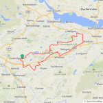
View attachment 198635
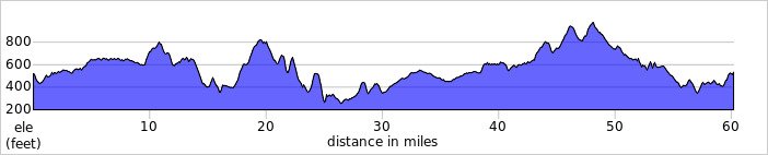
Yesterday was another calm day here but I had things to do in the morning so couldn't get out until late morning, I headed east to Blackridge where I turned north up the climb to Heights!
View attachment 198636
It was a cloudy day with a temp of 19C, if the sun had come out it would have been pretty hot so I was glad it stayed behind the clouds! I then enjoyed the descent from Heights and another cracking descent down into Bridgehouse! From there I turned north for Westfield and then east towards Torphicen, a flat road to begin with before the road ramps up through Torphicen!
View attachment 198637
A quick photo in the village before the second part of the climb up to Beecraigs Country Park!
View attachment 198638
I turned off before the country park to take the back road to Beecraigs Loch, grabbing some photos on the way!
View attachment 198639
A bit of a climb before the road drops down into the valley!
View attachment 198640
At the bottom of the descent looking back up, its very steep!
View attachment 198641
I was going to visit the loch for a couple of photos but it was very busy so I skipped it and made my way out of the valley, another big climb ensued but it was worth it for the views at the top!
View attachment 198642
View attachment 198643
View attachment 198644
View attachment 198645
View attachment 198646
The roads are pretty amazing also!
View attachment 198647
View attachment 198648
It was time for the big climb up to Kingscavil, I stopped at the top for more photos of the valley below!
View attachment 198650
View attachment 198651
View attachment 198652
I then enjoyed the big dipper road at Kingscavil, freewheeling down at 46mph! I never have the bottle to pedal down this one...its a bit scary even for me!

I stopped for a snack and a break and grabbed some photos!
View attachment 198653
View attachment 198654
View attachment 198655View attachment 198656
At the end of the road I turned east towards Threemiletown where I turned south for Uphall, from there I made my way through Dechmont and joined the cycle path to Whitburn and had it pretty much all to myself! I then took the cycle path up through Armadale and used the back road to Blackridge to enjoy that lovely new tarmac again!
View attachment 198657
View attachment 198658
From Blackridge I turned west for home but decided to head for Kirk of Shotts to enjoy the back road to Hareshaw again, I will never tire of this amazing road! Its just a blast everytime even if its into a strong headwind it still makes me smile!

Another fantastic ride on amazing roads, I only need 102 miles to reach 5000 for the year now but the weather isn't looking good this week so I will bide my time and if the opportunity arises I will grab it with both hands!
 Local buses are not bad either. For example, a Ramsgate bus 69 works on the "hop off hop on" principle, and you can explore the whole Thanet for just £6 a person!