2025 - Our Rides in Words, Photos, Maps and Videos

Jeremy, I don't think you use Smart Control, do you? User @GuruUno has described Smart Control/Specialized App glitches more than enough. It might be also dependent on the specific e-bike model.

In my own case, there were 4 motor off states on the ride. After the motor on, Smart Control was recovering, only it not necessarily reported the correct distance to the destination (I was correcting it manually). After the 81 km ride was completed, I only got a single recording for the first 21 km (Leg 1) but nothing beyond... It was a Vado 6.0. Smart Control is more reliable with Vado SL, proven.
No, never use Smart Control. Point is, the Specialized app is a solid recording option on rides not involving that mode — which for most riders is probably most of them.

If I ever use Smart Control, I'll record in RideWithGPS instead.
 
No, never use Smart Control. Point is, the Specialized app is a solid recording option on rides not involving that mode — which for most riders is probably most of them.

If I ever use Smart Control, I'll record in RideWithGPS instead.
I confirm Specialized App "Ride" has recorded my today's 4-segment ride correctly. The motor was switched off at each stop.
 
Last edited:
More Photos From Varmia Gravel 2025

Gravel.Love races can be proud of the photographic service it provides. Of course, the photographers are paid for their hard work, and they indeed deliver quality! However, this year's Varmia Gravel could employ too few professional photographers. The shortest format, Sprint/E-Sprint had only one photographer: a teenage girl, daughter to a professional photographer. The girl has a long way to go yet, from the selection of a good "photo trap" through the selection of the aperture and the shutter time, through avoiding high contrast scene to assuming a good shooting position (prone, kneeling, standing) :)

The digital photography leaves some space for improving the photo takes. I have thus improved the photos I am in :) (Adobe Lightroom).

1752003893488.png

My riding mate Paweł and I. I was just approaching a hanging bush and could see a patch of sand, so I had to slow down and think how to avoid the spill :)

1752003993492.png

Paweł's track was clear, so he gained on me there! (And he rode a full suspension MTB).

1752004049490.png

Suddenly, I noticed the young photographer sitting right on my track! I yelled "Aaaargh!", dramatically braked and changed the tracks. You can see me yelling! :D Hands squeezing brake levers, haha!


Not the best photos but what do. :)
 
Last edited:
1752066959095.png


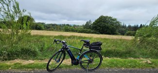
I'm on carer duties for a few weeks as I'm looking after my sister after a recent operation but I managed to get a ride in this morning, a local hilly one so I got a good workout! It was a blustery but mild morning, with a westerly wind around 25mph so I took advantage of the wind on the way out to Whitecross near Linlithgow! It was a dull morning with a slight threat of rain, I used the back road from Longriggend to Slamannan and stopped for a couple of photos! The Campsie Hills were shrouded in cloud in the distance!

1752071047706.jpeg

1752067445121.jpeg

From Slamannan I took the back road towards Avonbridge, this road has been closed for months so it was good to use it again and enjoy the awesome descent at the end of it!

1752067567587.jpeg

1752067579487.jpeg

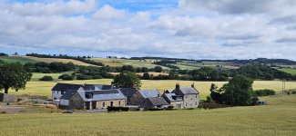
After enjoying the descent I had a big climb up the back road to Shieldhill and was looking forward to the big fast descent down into Glenn Village, the Ochill Hills were pretty clear today! I grabbed a few photos before heading down the descent!

1752067776588.jpeg

1752067850682.jpeg

1752067890131.jpeg

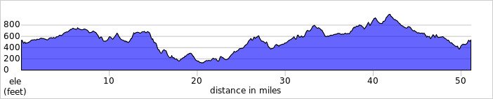
Time for the descent, 36mph down the first part!

1752067925787.jpeg

42.5mph down the steep part, the smooth tarmac makes quite a difference since it was resurfaced recently!

1752068021383.jpeg

1752068043629.jpeg

From Glenn Village I headed east through Hallglen where I had another amazing descent, after passing through Brightons I turned north towards Polmont and then east towards Linlithgow! A mile or so before Linlithgow I turned south towards Whitecross to enjoy this amazing road again!

1752068441195.jpeg

The scenery around here isn't too shabby either!

1752068479991.jpeg

You get this stunning view of the Ochill Hills after the climb!

1752068527873.jpeg

1752068544391.jpeg

1752068574824-jpeg.196628

1752068592050.jpeg

From Whitecross it was time to turn SW into the wind but the road is just incredible, a short time later I passed over the canal and stopped for a photo!

1752068713367.jpeg

I was now heading for Standburn where the road becomes a proper rollercoaster, I'm so lucky to have such amazing roads so close to home! After the final climb I turned south to take the back road to Avonbridge, another amazing road which starts with this lovely descent!

1752068890177.jpeg

Westfield village can be seen in the distance part way down the descent!

1752068935242.jpeg

From Avonbridge I turned south to take the back road to Blackridge! Its another rollercoaster road before the big climb up over Heights, I stopped for another couple of photos!

1752069340816.jpeg

This one is from the summit looking SE with the Pentland Hills way in the distance!

1752069430594.jpeg

From Blackridge I turned west towards Caldercruix but I decided to take the back road past Forrestburn Reservoir, it's really smooth in places and really rough in places also and some big climbs once again! A couple of photos of the reservoir!

1752070015454.jpeg

1752070078434.jpeg

At the end of the road I turned west towards Salsburgh to find the road closed after a big descent, thankfully I didn't need to turn back though as I used the little back road past Kirk of Shotts church which leads to my favourite back road to Hareshaw so I was more than happy with the closure! If I could I would ride this road every day as it's just incredible for the bike, if you meet 2 cars on this road you are unlucky and I only met 1 today and they actually pulled in to let me pass! Its very narrow... ;) From Hareshaw I took my usual back roads out to Newhouse, grabbing one final photo before turning for home!

1752070548091.jpeg

It remained dry for the whole ride so it was my lucky day, what a fantastic ride it was!👍 
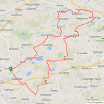
I'm just 18 miles short of 40000 now, I'm not sure when I will get out again though but if the opportunity comes along I will grab it! I'm also only 72 miles away from 4000 for the year, it has been a great biking year for sure despite some awful weather!
 

Attachments

  • 1752067431493.jpeg
    1752067431493.jpeg
    511 KB · Views: 14
  • 1752068574824.jpeg
    1752068574824.jpeg
    483.1 KB · Views: 75
  • elevation_profile417.jpg
    elevation_profile417.jpg
    21.7 KB · Views: 15
  • trip-305724412-map-full417.png
    trip-305724412-map-full417.png
    524.4 KB · Views: 17
More Photos From Varmia Gravel 2025

Gravel.Love races can be proud of the photographic service it provides. Of course, the photographers are paid for their hard work, and they indeed deliver quality! However, this year's Varmia Gravel could employ too few professional photographers. The shortest format, Sprint/E-Sprint had only one photographer: a teenage girl, daughter to a professional photographer. The girl has a long way to go yet, from the selection of a good "photo trap" through the selection of the aperture and the shutter time, through avoiding high contrast scene to assuming a good shooting position (prone, kneeling, standing) :)

The digital photography leaves some space for improving the photo takes. I have thus improved the photos I am in :) (Adobe Lightroom).

View attachment 196591
My riding mate Paweł and I. I was just approaching a hanging bush and could see a patch of sand, so I had to slow down and think how to avoid the spill :)

View attachment 196592
Paweł's track was clear, so he gained on me there! (And he rode a full suspension MTB).

View attachment 196593
Suddenly, I noticed the young photographer sitting right on my track! I yelled "Aaaargh!", dramatically braked and changed the tracks. You can see me yelling! :D Hands squeezing brake levers, haha!


Not the best photos but what do. :)
I'm guessing she screamed as well
 
I rode the Moss path which is actually the UK coastal path, it sits on top of the flood defence from the Ribble river, and its very long and a bit boring.
mos1.jpg


The only fun is the very tight kissing gates, I gave up and opened the main gate
mos2.jpg


These cows were all on top of each other in a cool bit, it was so cute.
mos3.jpg


Less happy here as they could reach me, though I'm pretty sure they didn't have the slightest inclination to do so.
I'm now riding down a tributary river from the Ribble towards where I can turn off to visit Bank Hall.
mos4.jpg


I had to pick the bike over here to enter the boatyard and I got a hand full of very smelly cow dung, those bovines got me eventually.
mos5.jpg


This was delightful, a mixture of boats and caravans.
mos6.jpg


I had hoped to cross over here, but the whole area was strictly private including the walkway over the lock,
mos7.jpg


I used google maps in bike mode to carry on and it took me down this path, I thought they would be annoyed but he agreed it was a proper cycle path.
There were lots of volunteers and boats clearing the river of rubbish and weeds.
mos8.jpg


It got more and more unsuitable until I rode across this edge walkway, stopped to film the volunteers, put my foot down and there was nothing there.
Straight up to my thighs in the river, much to their amusement.
mos9.jpg


When I got to the Jacobean hall it turned out it has been converted into apartments, very snazzy place to live.
Built in 1608 you have to book a guided tour, it was remodelled in 1830 to a more extreme Jacobean style and mixed with Georgian.
mos10.jpg


On the way home Google maps took me through this field..
mos11.jpg


And through this farm, there were caravans, containers, huts and camper vans everywhere with migrant workers living in them for harvesting work.
mos12.jpg


These roads are quiet enough for locals to feelsafe walkingtheir dogs around blind bends, which is very trusting as they have 60mph speedlimits
mos13.jpg
 
These roads are quiet enough for locals to feelsafe walkingtheir dogs around blind bends, which is very trusting as they have 60mph speedlimits
Trusting, eh? Notice who's in the middle of the road.

Actually, it's the same in my neighborhood with narrow streets and no sidewalks. When not behind the wheel themselves, all pedestrians here operate under the deeply held belief that there couldn't possibly be a car coming.
 
Last edited:
Trusting, eh? Notice who's in the middle of the road.

Actually, it's the same in my neighborhood with narrow streets and no sidewalks. When not behind the wheel themselves, all pedestrians here operate under the deeply held belief that there couldn't possibly be a car coming.
It’s the same here though in greener (and less green$) circumstances. I’ll be pedaling uphill on a lane and a half of chip seal and some gun past me into a curve. But the worst are the Sunday morning biddies late for church…they’re worse than the beered up Friday afternoon tradesmen who at least have good eyesight. I’m scaring myself…
 
I'm guessing she screamed as well
Nope. She seems to have never realised what she was doing was wrong and dangerous... Fancy her sitting on an asphalt road?

On the way home Google maps took me through this field..
Google Maps is as accurate a cycling navigation tool as... (I bit my tongue!) :D Chris, please invest in Komoot. You need no subscription! Only it is advisable to pay a one-time flat fee to "unlock all regions" (it is the most economical option). The strength of Komoot are very accurate maps that can distinguish Cycling, Road Cycling, MTB, Gravel Cycling, and Enduro MTB (as well as Hiking and Mountaineering). Komoot also shows Heatmaps (whether and how often someone rode that trail), and there are even photos of the trail (on a computer)! You do not need to navigate using Komoot. You do not need to record your rides either. You could, however, plan your routes according to your activity type (MTB) to see if the trails in the area would be rideable or not. Komoot even creates a list of warnings for the route ("This part is unrideable. You will need to push your bike" and it will show you the location). Same with stairs etc.

Don't like planning? In case you are lost on your ride, open Komoot then click Routes -> Plan New. Your GPS location will be shown on a very accurate cycling map and then you can make a decision what to do next. I actually do the same on my long rides! (I use a pre-planned route to see how my course deviates from the plan, or, where I actually am).

1752114425128.png

The website version shows you tons of Points Of Interest, and it is more and more as you zoom in. The green dots are to see the photos. (This map shows the former Military Range, a fascinating area where it is exceptionally easy to get lost without a good navigation or a map).

1752114656469.png

Google Maps Cycling :D :D :D


These roads are quiet enough for locals to feelsafe walkingtheir dogs around blind bends, which is very trusting as they have 60mph speedlimits

Ireland is a funny country as any narrow and twisting asphalt road has the speed limit of 100 km/h while you can drive perhaps 30 km/h there :)

1752114932047.png

The roads on the Wild Atlantic Way can be as narrow as when I stopped here to take that photo, a grandfather carrying his family in his car had to stop behind me! It was, of course, a 100 km/h road :D
 
Last edited:
Actually google maps were correct, that was a bridleway, the farmer is OK to plough over it and the canal path is also a bridleway, the signs have long gone and no one has bothered to replace them.
Its pretty laid back in the UK and riding through a farmers field is very unlikely to end in birdshot in the arse.
Chris, Komoot allows unlocking a single "region" for free. Please just try it. Why to ride through a someone's field if a more interesting path could be found?

1752138353219.png

Komoot let me find a very interesting shortcut in my nearest neighbourhood. The red line is a former gravel road. The farmer not only ploughed the field but also installed a mighty concrete barrier (black) to protect the field several years ago. Turns out, there is a hidden dirt path marked here with a blue arrow that allows the passage! How would I discover that if not Komoot?
 
Last edited:
More interesting than a ploughed field?
I dont think so
It's good for you to live in Britain :) Do it in Poland and you end up:
  • A horse-cart stanchion hit over your back, or
  • A scythe in your back, or
  • A mountaineer axe in your spine :D
We hardly use fences or hedgerow to protect the fields in Poland. We've been taught a hard lesson to respect the private property for years :)

There was a series of comedy films by name "Sami swoi" ("Their own") in Poland. A farmer in Poland's Far East (pre-WW2) incidentally ploughed his neighbour's field two fingers wide :) The neighbour sent his son to defend the property; the son wounded the offender with a scythe. As the outcome, the boy had to escape to the United States :D The feud continued well after WW2 when those two families were incidentally relocated to the same place in Poland's Far West :D

Be careful!

1752142340480.png

The U.S. immigrant (the scythe boy) to present a sickle to his Polish nephew (in order to oppress the neighbours even more!)
 
Last edited:
Back