2024 - Our Rides in Words, Photos, Maps and Videos

Is your weather good every day? it certainly seems to be and I'm just a little jealous despite it being lovely here today...;) Its supposed to be nice tomorrow also so I will almost certainly be out on the bike tomorrow after missing out today!
The weather here has been very good this year. I have usually been able to get out riding 5 or 6 days a week.
 
I rode to a nearby state park called Argyle. It has a lake and a road around the lake that is very curvy and has some steep hills. I ended up with about 18 miles and just under 1100 feet of elevation gain, most of that in the 5 miles around the lake. A few pictures of the lake and the road across the dam.

IMG_3629.png
IMG_3628.jpeg
IMG_3627.jpeg
IMG_3626.jpeg
 
Still here.
Rode the bike around the corner from my dads nursing home to find this incredibly atmospheric viaduct, still in use, the towers on the right are the leftovers of the
original structure built by good old Isambard Kingdom Brunel, finished in 1848,

The construction of the South Devon Railway was granted by an Act of Parliament in 1844. The last 21¼ mile stretch linking Totnes with Plymouth required the building of five substantial viaducts designed by the engineer Isambard Kingdom Brunel (1806 – 1859). A newspaper article from 10 May 1848 reporting the official opening of the line, describes the spectacle marvelled by the first travelling passengers.

JMM2.jpg
find

Its over 100ft high, I have no idea why they left the original pillars, maybe ground compression or something, the little wood and river is incredibly serene and
beautiful, I really felt like I'd discovered some ancient remains in the Amazon
JMM3.jpg


Quite imposing arching over you alongside the free standing remains of the Brunel structure
JMM4.jpg


You access it down this gorgeous riverside path
JMM6.jpg


Then on to the bridle path to the Dartmoor way, the British love a good sign......which we ignore.
JMM9.jpg


The eyes on the black sheep
JMM11.jpg


Pretty well straight up for five minutes of full power, bottom gear.
JMM14.jpg


The bike can make it, but the constant rocks and tyre grabbing holes puts you your stride, I'm just too old to wrestle with it for long c,imbs.
JMM15.jpg


There are wild ponies and horses on Dartmoor, all the mares were white and the foals black, a hiker joked with me that there must be a black stallion somewhere
and dont wear white 🤣
JMM16.jpg


Ive never seen panda cows before
JMM17.jpg


I climbed a Tor, they are granite outcrops on featureless land, the word means tower in Celtic.
JMM18.jpg


Cute calf procession
JMM19.jpg


Ivybridge itself is mostly very ordinary, a generic any town.
JMM21.jpg


Probably its best feature is the river through the centre.
JMM22.jpg


oh and the women
Holy smokes it is full of stunning women, you cant go into any supermarket without falling in love before you leave.

I might stay.
 
Then on to the bridle path to the Dartmoor way, the British love a good sign......which we ignore.
JMM9.jpg
I could see so many gates on your way in so many of your videos. Will all of them open? How does entering a private property is looked upon in Britain?

I'm asking it out of curiosity. For instance, you are free to enter any private property (but not the home!) or a public area in Sweden as long as you behave there and are respectful. In Poland, all public areas have a free access but you are not allowed to enter the private property (the latter is as clear to the Poles as even most of fields are not fenced!)
 
Last edited:
I could see so many gates on your way in so many of your videos. Will all of them open? How does entering a private property is looked upon in Britain?

I'm asking it out of curiosity. For instance, you are free to enter any private property (but not the home!) or a public area in Sweden as long as you behave there and are respectful. In Poland, all public areas have a free access but you are not allowed to enter the private property (the latter is as clear to the Poles as even most of fields are not fenced!)
They are simply livestock gates on a public way, stop sheep and cattle taking a wander into town.

No, you wouldnt enter a private path unless it also contains a public way.

Its no big deal though, simply 'sorry Im lost' and turn around.
 
You sure do make up for it when you do get out though. ;)
Yes I do, any opportunity for a big ride is taken with gusto and today was the case in point! ;)

1725550991258.png


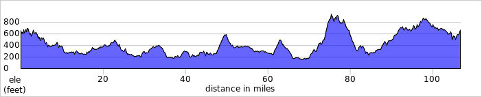
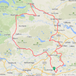
I noticed I hadn't ridden out to the beautiful Trossachs since June so with a decent forecast today I put that right! The wind was from the NE and around 20mph which is unusual for around here and it didn't really help me until late in my ride and I sure needed it! I set off just before 7am in a northerly direction down the back roads towards Cumbernauld, it was a little chilly but just nice for riding the hills!

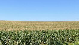
Early morning view of the Campsie Hills, I was just skirting round them today until late in my ride!

1725551404515.jpeg

From Cumbernauld I took the back road through Twechar and on through Kirkintilloch where I truned north for Lennoxtown and had another view of the Campsies down this awesome descent!

1725551576179.jpeg

I stopped at the Whitefield Pond in Lennoxtown for a snack and a photo!

1725551660336.jpeg

From there I was heading west towards Strathblane and heard a truck approaching and I knew I had a climb coming just round the bend, I spotted a tiny road off to the left and decided to pull in to let the truck pass and I got a little beep of his horn to say thanks! I noticed there was a line of cars behind the truck, I was holding him up and he was holding them up!😂While I was waiting for them to pass I noticed a little bridge just around 100 yards up the tiny road and walked up to investigate and came across this lovely view!

1725553351151.jpeg

A little later I reached Strathblane where I turned north on to the main A81 which runs all the way to Aberfoyle, thankfully the road wasn't busy so I got lucky! I was nearing the village of Dumgoyne and stopped for this photo of the A81 at the Glengoyne Distillery! I didn't stop for any samples as I hate whisky...I guess I'm not a true Scot!🤣 I continued along the A81 and reached this long straight with a nice descent and a very nice view of the mountains surrounding the Trossachs National Park!

1725553971373.jpeg

I stopped again at the bottom of the descent for these photos!

1725554068984.jpeg

1725554083658.jpeg

Most of the A81 is in very good condition, I just love riding this road!

1725554274508.jpeg

I reached the turnoff for Aberfoyle but decided to give it a miss this time and turn east towards Thornhill instead, the reward for going this way is the stunning Lake of Menteith!

1725554474275.jpeg

1725554487094.jpeg

One of the reasons I chose this route was the road from Thornhill to Callander which starts with a huge climb and culminates in a truly awesome descent! This is the first climb and it just keeps going up for almost 3 miles!

1725554640940.jpeg

The descent makes the climb worth the effort and the stunning views just keep coming!

1725554794352.jpeg

I arrived in Callander and stopped on the bridge in the centre of town for some photos, what a beautiful day it was!

1725554861515.jpeg

1725554875917.jpeg

1725554893053.jpeg

Callander was my turning point so it was time to turn SE on the main A84, a very busy road at times but I timed it nicely today and really enjoyed riding it for many miles which are mostly downhill until I reached Doune! At Doune I decided to take the road to Bridge of Allan which starts with some big climbs and is followed by some brilliant descents!

The scenery isn't too shabby either!

1725555906021.jpeg

1725555920026.jpeg

1725555933291.jpeg

1725555946583.jpeg

The road is in great condition for the most part!

1725555988028.jpeg

I passed through a busy Bridge of Allan and turned south for Stirling, the only city I choose to ride my bike through! I know it well and can avoid the congested parts! Now came the huge 4 mile climb from Stirling up over the Campsies, only this time the wind was in my favour and it made the climb so much easier than it usually is!

It really ramps up just after this part!

1725556328412.jpeg

Then comes the steepest part up past Loch Coulter!

1725556362735.jpeg

At the top I had an amazing view of the Ochils!

1725556408805.jpeg

1725556424957.jpeg

Loch Coulter!

1725556443739.jpeg

Now I had some big descents to look forward to, at first the road rises and falls like a rollercoaster in parts before arriving in the Carron Valley where I turned east towards Denny and had a 4 mile descent to bask in! That sure was fun despite the 20mph headwind, it didn't slow me down much!;) From Denny I took the road to Bonnybridge with the intention of taking the back roads up to Falkirk, only to be stifled by a road closure! I thought about chancing it but came up with a nice alternative instead, taking the road to Abronhill where I made a wrong turn which turned out to be a blessing as I enjoyed a very narrow back road with no traffic anywhere!:D

The road eventually brought me out on the road I was intending to take, I really wasn't sure where it would go...😂

1725557386480.jpeg
I then tackled the climb up through Upperton to Longriggend, at the top of the climb I had ascended for just over 14 miles and was feeling it! I enjoyed the descent down Telegraph road into Caldercruix where the 100 miles appeared on my gps, then it was a straight road home and as I arrived in my home town I thought I would head out to the big fast descent at Gartness as the wind was in my favour today! 45.3mph down the booze brae as its known, Inverhouse whisky distillery is close by hence the name!

I arrived home knackered but absolutely buzzing after a brilliant day on the bike!😁 That was imperial century #17 for the year, 3 more than I did in my best year in 2012 way before my e bike days!
 

Attachments

  • elevation_profile341.jpg
    elevation_profile341.jpg
    23.4 KB · Views: 10
  • trip-218370067-map-full341.png
    trip-218370067-map-full341.png
    490.9 KB · Views: 8
They are simply livestock gates on a public way, stop sheep and cattle taking a wander into town.

No, you wouldnt enter a private path unless it also contains a public way.

Its no big deal though, simply 'sorry Im lost' and turn around.
In rural areas here (Washington State, and especially east of the Cascades) gates often have an open grid of steel bars to discourage livestock from moving through. When a local politician learned that the state was responsible for "cattle guards," he was offended that the state was hiring people to guard cattle. He lost the next election, as I recall.
 
Last edited:
Black & White

I was wondering whether putting the screen of my Samsung S24 U smartphone into the Greyscale mode would result in any power saving. The short answer is: it would if you had the screen open all the time and your phone were on the bars :) However, I use my phone only during the stops, so the gain (if any) was minimal. On the other hand, watching the screen in the shades of gray was a hilarious experience! Bear in mind, the phone "thinks" colour all the time (for instance, any screenshot or a photo is still a colour one, only you see it in black & white). Anyway, I was converting rare photos from my ride to B&W just to give my FB friends an idea what I was seeing on my smartphone myself! :)

The ride plan was: Vado SL at 60/100%. Ride upwind for a 30 km segment, make a loop through Warsaw, return home (possibly with tailwind or cross-wind all the time). I was running Strava Beacon so my mate Tomek could intercept me in Warsaw (he knew where I was and how fast I was riding all the time).

1725744375477.png

My ride was a workout to prepare for the Great Lakes Gravel race. I was testing the assistance vs. range, and tried doing minimal stops, especially as it was pleasantly cold at that time!

My upwind segment lead me to the village of Łoś (Elk). I tried to do a shortcut (by Komoot) but I could not believe my eyes! The whole dirt road got damaged by boars (which used to feed in the area). Cursing, I had to return to the main road and found a pretty long detour! Meanwhile, the day became hot.

1725744482556.png

A longer stop in Zalesie Górne. It was full sunshine already.

1725744544741.png

"All Roads Lead To Kierszek" :) Whenever you approach Kabacki Forest from the south (or have missed your way in the Forest), it is easier to find yourself in Kierszek than elsewhere! As I hate riding through Kierszek, I tried to give the photo some post-apocalyptic looks :)

1725744811886.png

Tomek intercepted me at Specialized Warsaw (it was
nothing interesting there on the day. Even my Creo 2 had disappeared!) We rode to the META Bar as planned for lunch. (The beer here is some crappy big brewery non-alcoholic ale).

1725744938695.png

I stopped "racing" and just enjoyed my ride with several stops. Here, two men playing ping-pong in a huge housing quarter of Ursynów.


1725745139088.png

Average Street? Really? :D

As I reached my local BP service station for traditional Iced Coffee, I realised I might make a Metric Century if I only wanted. Found a very well hidden car-wash (where I washed my Fearless), did shopping etc. When I arrived home with 100.01 km for the day, I only put any electronic device on charging and fell in a deep sleep :)

1725745370847.png

Now, an old friend invited me for a visit on Sunday. I can see another Metric Century coming perhaps. Or, not ;)
 
Last edited:
Back