My luck ran out last Thursday when I got properly soaked on a 50 mile ride, it was another very windy day surprisingly...

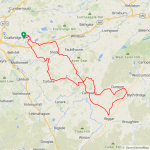
Fast forward to today and the weather was so much nicer, still windy of course but not the crazy winds we have been getting! I started on the main roads because it was a Sunday but that backfired very quickly with so many trucks around so I took to the back roads after 7 miles and passed through Allanton and Carluke before heading for Yieldshields and amazing roads like this!
The main herd of Alpacas were too far away for a photo but I caught these 4 lounging around and totally ignoring me!
I then enjoyed the quiet back roads out to Kaimend, grabbing a couple of photos on the way!
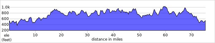
From Kaimend I hurtled down the descent into Newbigging before turning east towards Dunsyre where I had some stunning views of the Pentland Hills, I couldn't stop taking photos...
I used the narrow back road to Walston which I enjoyed recently in the other direction, its just amazing!
It dissects the hills and has a huge descent at one end and a huge climb at the other!
After passing through Walston I had a stunning descent followed by a big climb and the stunning views just continued!
At the end of the road I joined the main A702 which heads south into Biggar but I spotted a sign saying there was a vintage rally in Biggar and to expect delays so I turned off the A702 and joined the A721 to Elsrickle, it starts with this long gradual climb!
This was near the top looking back down, shame I wasn't going down it today as it would have been wind assisted! At the top I was greeted by this lovely scene!
I was sure glad I chose to head for Elsrickle!

I then took the back road towards Biggar but stayed well away from the town, I had a nice view of the Coulter Hills here!
I then turned NW towards Carnwath and up the back road to Braehead, a big climb up through the village!
Then its a cracking descent down the other side on the back road to Forth, as soon as I arrived in Forth I took the back road up the big climb to Climpy! Then it was the big descent down into the valley and on to Shotts!
At Shotts I had 10 miles to go and enjoyed the lovely new tarmac on the road from Harthill to Salsburgh, it was closed for a month but it was well worth the wait! A big climb followed by a big descent but it was directly into the strong breeze! At Salsburgh I took my usual back roads to home and arrived just before dinner time and feeling pretty tired but totally elated after a truly amazing day on the bike! It really was a fantastic ride and I'm still buzzing many hours later!

 .
.