You are using an out of date browser. It may not display this or other websites correctly.
You should upgrade or use an alternative browser.
You should upgrade or use an alternative browser.
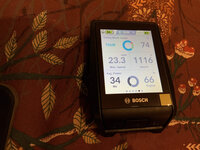
Adjuting the power level in each assist mode using Bosch NYON
- Thread starter Ravi Kempaiah
- Start date


fooferdoggie
Well-Known Member
what kind of bluetooth devices can it connect to or just HRMs?


When it first appeared, I tried the old Nyon on my Trek Powerfly 7 - too big and a sod to connect to my phone. Then the Kiox - too small and didn't like the magnetic attachment. And then, in early October, I bought the new Nyon and liked it so much I fitted one to my other bike and to hell with the £££s - my early Christmas present! It connects quickly with GPS, my chest HRM and Bosch eBike Connect. I paid Bosch £4 to be able to change the assistance levels (brought them closer together at even intervals) and have never looked back. A brilliant addition to my eBikes! Anyone want a Intuvia retrofit kit? Or a Purion?")
Last edited:
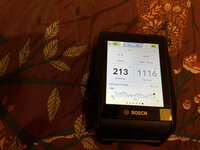
Five seconds for the initial screen to appear, fifteen seconds all data screens operational, twenty seconds map focussed.Can I ask, how long does your Nyon take to come on from being properly off (not just screen off)? Mine seems to take ages even though I have the maps downloaded and the maps looks out of focus for ages!
WinterKill
Member
- Region
- USA
- City
- East Bethel
Could it be your location? Does it have a clear view of the sky? I think the GPS needs to at least 4 satellites to calculate your location. Buildings or trees blocking the view of part of the sky will slow it down.That’s weird. Mine takes 55 - 60 seconds for the map to come up and my location to me marked on it! It spends ages with what looks like an out of focus map on the screen. Not sure why mine’s different - it has the latest software etc and the map downloaded too!
I thought that too but it seems to make no difference. I also loaded the German maps too that I’d previously deleted in case that made a difference but it didn’t. I’ll have to speak to Bosch TS tomorrow but I’ll probably have to take it into a dealer which I can’t because were all in lockdown at the moment..grrrr..
Nycturne
Member
That’s weird. Mine takes 55 - 60 seconds for the map to come up and my location to me marked on it! It spends ages with what looks like an out of focus map on the screen. Not sure why mine’s different - it has the latest software etc and the map downloaded too!
A few things can affect lock time:
* Location, as WinterKill mentioned. Trees and buildings both block and cause reflections which mess with precision.
* Out of date ephemeris data. If the Nyon has to grab updated ephemeris data to get a lock, then it can take up to 30 seconds while it waits for the next broadcasting window from the satellites. Smartphones will grab this data over local networks instead (A-GPS).
* What precision is considered a “lock”. My Garmin just tends to do “best effort” and will lock even when accuracy is bad, letting the position on the map “jitter”, but won’t lose lock in the wilderness. My iPhone is more selective, but with A-GPS, it’s able to get that precision much faster than stand-alone units. With car units like Garmin/TomTom, they “snap to road” which lets them operate with lower accuracy.
I wonder if the Nyon is expecting a fairly precise lock? Low precision would lead to weird snapping behaviors when providing guidance in areas where cycle paths run alongside roads, but demanding higher precision means needing the latest ephemeris data.
I’m still waiting on my local dealer to get the retrofit kit in stock, so I haven’t had the chance to play with one myself, so I can’t really say much other than guesses based on my knowledge of the tech, really.
I should qualify the times I initially quoted... early this morning I switched the Nyon on (indoors) and it did take about 50 seconds for the map to become focussed.That’s weird. Mine takes 55 - 60 seconds for the map to come up and my location to me marked on it! It spends ages with what looks like an out of focus map on the screen. Not sure why mine’s different - it has the latest software etc and the map downloaded too!
GPS needs 3 satellites for a 2 dimensional fix & 4 for a 3D fix (latitude, longitude & elevation).
Depending on how the Nyon is designed to obtain & retain GPS data:

 en.wikipedia.org
The blurry image is from how the Nyon is designed to use image data:
en.wikipedia.org
The blurry image is from how the Nyon is designed to use image data:
Depending on how the Nyon is designed to obtain & retain GPS data:
Time to first fix - Wikipedia
The Difference Between Interlaced and Non-Interlaced Images
Take a look at the difference between interlaced images and non-interlaced images to decided which to use on your site.
www.ledfrog.com
Yup! Monmouth area.That’s weird. I spoke to Bosch TS yesterday and they said it may be something peculiar in my area. You’re not from South Wales are you, by any chance?
Nycturne
Member
Huh, maybe we need to wait for a Welsh update!
Anyone know what GPS constellations the 2021 MY Nyon supports? With the US, EU and Russia all having their own constellations, I wonder if it's something as simple as slower lock due to not supporting the Galileo constellation, or configured to prefer GLONASS instead? I would hope it supports Galileo, but it took a surprising amount of time for Garmin/etc to add it to their devices.
The blurry image is from how the Nyon is designed to use image data:
The Difference Between Interlaced and Non-Interlaced Images
Take a look at the difference between interlaced images and non-interlaced images to decided which to use on your site.www.ledfrog.com
In this case, it could also just be blurring out the map display to show that there's no lock yet.
Interlaced images are good for pulling over the network and showing something before it's been pulled down, but not applicable when talking about vector map data. There's very few situations where you'd need tiled image data for a map, like satellite imagery as a background, and those images eat bandwidth and storage. Outside of satellite imagery, tiled images only really showed up in older browsers before the introduction of things like the Canvas tag and WebGL which made drawing vector data fast for browsers.
I think the rollout timeline for GPS constellations has been GPS (US), GLONASS (Russia), BeiDou (China) & then Galileo (EU).Anyone know what GPS constellations the 2021 MY Nyon supports? With the US, EU and Russia all having their own constellations, I wonder if it's something as simple as slower lock due to not supporting the Galileo constellation, or configured to prefer GLONASS instead? I would hope it supports Galileo, but it took a surprising amount of time for Garmin/etc to add it to their devices.
In this case, it could also just be blurring out the map display to show that there's no lock yet.
Interlaced images are good for pulling over the network and showing something before it's been pulled down, but not applicable when talking about vector map data. There's very few situations where you'd need tiled image data for a map, like satellite imagery as a background, and those images eat bandwidth and storage. Outside of satellite imagery, tiled images only really showed up in older browsers before the introduction of things like the Canvas tag and WebGL which made drawing vector data fast for browsers.
You're probably right about the blurry imagery, if the thing was that slow then moving maps would be clunky too which i'm sure it's not.
Similar threads
- Replies
- 25
- Views
- 27K
- Replies
- 20
- Views
- 12K
- Replies
- 18
- Views
- 26K
- Replies
- 51
- Views
- 15K