DaveMatthews
Dave's not here. Cheating since 2018
- Region
- Canada
Good point!Lovely, you can see its very steep by the angle of the trees, I often tell people to use that as a guide when viewing lens flattened out terrain
Good point!Lovely, you can see its very steep by the angle of the trees, I often tell people to use that as a guide when viewing lens flattened out terrain


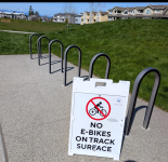
Went out for another quick jaunt today. Weather even nicer than yesterday!
No pics to speak of except for this one I took at the park. First time seeing this...
Thanks a lot to whomever screwed that up...
Admittedly I see an increase in those Surron type machines. Never seen one at that park, but have seen numerous scooters (except for today).Yeah, we had a sign like that go up at a nearby park just in the last month. Grrrrr.
In your case, they're telling us who screwed it up. The graphic they chose for an "ebike" is a Surron-like e-moto.
The dishonest e-moto manufacturers and dealers who've perpetuated that false equivalence are the main culprits. And the parents who put 14 year old males on them and turn them loose on the world have been their dupes. I wish a plague on all of them.


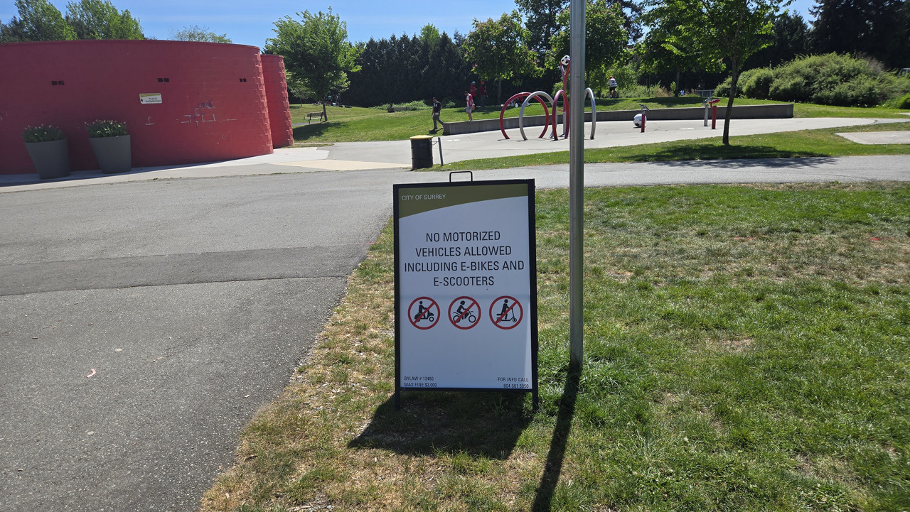
Yeah, we have a similar sign in our park. Weirdly, only restricting ebikes on the walking track surface. I guess ebike tires are harder on the track than bike tires?
I bet your sign has as shaky a legal footing as the one in my town. Ours references a city code that prohibits motor vehicles in city parks and ebikes are specifically not motor vehicles according to state law.
View attachment 209515
Yes, probablyThey might be trying to protect the track from the kids who think that every surface that CAN be marred with donuts and rooster tails should be. We have quite a few of those around here.
Probably. I can still still count on my hands the number of e-motos I've seen in our little downtown. They are a little more common up in the residential neighborhoods.Ours might have a firmer legal basis. Carlsbad's enacted a lot of ebike-related laws since 2022. Most have been reasonable responses to the explosion of ebikes in public places. Sad to see this new application, however.
View attachment 209516
They might be trying to protect the track from the kids who think that every surface that CAN be marred with donuts and rooster tails should be. We have quite a few of those around here.
They are vandals who don't care about laws, let alone a sign.Ours might have a firmer legal basis. Carlsbad's enacted a lot of ebike-related laws since 2022. Most have been reasonable responses to the explosion of ebikes in public places. Sad to see this new application, however.
View attachment 209516
They might be trying to protect the track from the kids who think that every surface that CAN be marred with donuts and rooster tails should be. We have quite a few of those around here.

hey its saying no hub drive bikes so if you have a mid drive your goodYeah, we have a similar sign in our park. Weirdly, only restricting ebikes on the walking track surface. I guess ebike tires are harder on the track than bike tires?
I bet your sign has as shaky a legal footing as the one in my town. Ours references a city code that prohibits motor vehicles in city parks and ebikes are specifically not motor vehicles according to state law.
View attachment 209515
Gorgeous! I remember massive thunderheads like that from our Denver days. Always spectacular, even without that amazing lighting!
Completely delicious, thats exactly what I want my life to be everyday, Ive been lucky enough to have it mostly, but I do need the opposite once a week to keep it sweet.A short but magical coast ride
Yesterday afternoon's absolutely magnificent 13.5 mi Coast Highway ride featured temps in the upper 60s, a chilly onshore breeze, and the clearest air and most vivid scenery colors I've seen in our 4 years here. The photos below have only been resized. They don't do the color I saw justice.
View attachment 209636
The views were good enough to warrant 5 stops in the 5 mi I was actually right on or above the water. Usually tried to put in 150-225W between stops and to and from the Coast Highway to get a little exercise, but it was a deeply relaxing, restorative ride nonetheless.
In fact, if the ride had come with its own soundtrack beyond the music of wind, waves, birds, and bike, it probably would have sounded a lot like this. Listen as you look through the photos to get the proper mood.
View attachment 209637View attachment 209638View attachment 209640
The 5 mi coast segment started on the bluff above Tamarack Beach (above) near Agua Hedionda Lagoon and proceeded south to South Ponto Beach at Batiquitos Lagoon. I ride through here a lot and had never seen the color pop like this!
View attachment 209641
You'll see 2 recurring skyline landmarks ~40 mi apart in this post: Saddleback Ridge (above) in Camp Pendleton, some 17 mi WNW of Tamarack...
View attachment 209639
...and the La Jolla Peninsula some 22 mi SSE of Tamarack. Most days, these coastal uplands are just dark featureless hulks on the skyline, bookends to the stretch of coast locals call North County. But this day, they seemed much closer and showed exceptional detail.
View attachment 209642
The faint landmass low to the horizon on Saddleback's far west (left) here is Santa Catalina Island, some 63 mi WNW from this spot.
View attachment 209645
View attachment 209643
Next, a quick stop at a favorite vantage over the south end of Tamarack Beach. The house marks the north end of the very posh bluff-top neighborhood of Terramar Point.
View attachment 209646
Next stop, a chance to get much closer to the water at North Ponto Beach. The closer the waves, the more you feel their energy and rhythm. Swell comes to our shores from all over the Pacific basin and adjoining Southern Ocean, with the longest-period waves (up to 20 seconds) having traveled the farthest.
View attachment 209649View attachment 209647View attachment 209648
Next, a quiet campground overlook above South Carlsbad State Beach. La Jolla's getting closer. South Ponto Beach nestles between this bluff and the next one south.
View attachment 209650View attachment 209651View attachment 209652
Next, a stop on the berm down on South Ponto Beach. The chilly wind had picked up, and only a few hardy beachgoers and a lifeguard patrolling on a quad remained.
View attachment 209653View attachment 209658View attachment 209655View attachment 209656View attachment 209657
Last stop, the bluff over the south end of south Ponto Beach, where I had a close encounter of the wonderful kind with a southbound flock of pelicans — here ascending on the cliff-face updraft. No wings were flapped.
View attachment 209654
As you can see from the handy compass rose, the coastline here runs roughly NNW-SSE.
View attachment 209660
If you zoom in, you can see more skyline landmarks to the north: Santa Margarita Peak (~3,000 ft) to the far right at the south end of the Santa Ana Mountains, and to its west, Santiago Peak (5,689 ft) at the north end.

Nobody swimming Jeremy? That looks like a nice July day in Ireland, the beaches would be rammed! Are these beaches prone to rips or dangerous currents?A short but magical coast ride
Yesterday afternoon's absolutely magnificent 13.5 mi Coast Highway ride featured temps in the upper 60s, a chilly onshore breeze, and the clearest air and most vivid scenery colors I've seen in our 4 years here. The photos below have only been resized. They don't do the color I saw justice.
View attachment 209636
The views were good enough to warrant 5 stops in the 5 mi I was actually right on or above the water. Usually tried to put in 150-225W between stops and to and from the Coast Highway to get a little exercise, but it was a deeply relaxing, restorative ride nonetheless.
In fact, if the ride had come with its own soundtrack beyond the music of wind, waves, birds, and bike, it probably would have sounded a lot like this. Listen as you look through the photos to get the proper mood.
View attachment 209637View attachment 209638View attachment 209640
The 5 mi coast segment started on the bluff above Tamarack Beach (above) near Agua Hedionda Lagoon and proceeded south to South Ponto Beach at Batiquitos Lagoon. I ride through here a lot and had never seen the color pop like this!
View attachment 209641
You'll see 2 recurring skyline landmarks ~40 mi apart in this post: Saddleback Ridge (above) in Camp Pendleton, some 17 mi WNW of Tamarack...
View attachment 209639
...and the La Jolla Peninsula some 22 mi SSE of Tamarack. Most days, these coastal uplands are just dark featureless hulks on the skyline, bookends to the stretch of coast locals call North County. But this day, they seemed much closer and showed exceptional detail.
View attachment 209642
The faint landmass low to the horizon on Saddleback's far west (left) here is Santa Catalina Island, some 63 mi WNW from this spot.
View attachment 209645
View attachment 209643
Next, a quick stop at a favorite vantage over the south end of Tamarack Beach. The house marks the north end of the very posh bluff-top neighborhood of Terramar Point.
View attachment 209646
Next stop, a chance to get much closer to the water at North Ponto Beach. The closer the waves, the more you feel their energy and rhythm. Swell comes to our shores from all over the Pacific basin and adjoining Southern Ocean, with the longest-period waves (up to 20 seconds) having traveled the farthest.
View attachment 209649View attachment 209647View attachment 209648
Next, a quiet campground overlook above South Carlsbad State Beach. La Jolla's getting closer. South Ponto Beach nestles between this bluff and the next one south.
View attachment 209650View attachment 209651View attachment 209652
Next, a stop on the berm down on South Ponto Beach. The chilly wind had picked up, and only a few hardy beachgoers and a lifeguard patrolling on a quad remained.
View attachment 209653View attachment 209658View attachment 209655View attachment 209656View attachment 209657
Last stop, the bluff over the south end of south Ponto Beach, where I had a close encounter of the wonderful kind with a southbound flock of pelicans — here ascending on the cliff-face updraft. No wings were flapped.
View attachment 209654
As you can see from the handy compass rose, the coastline here runs roughly NNW-SSE.
View attachment 209660
If you zoom in, you can see more skyline landmarks to the north: Santa Margarita Peak (~3,000 ft) to the far right at the south end of the Santa Ana Mountains, and to its west, Santiago Peak (5,689 ft) at the north end.
Wow Rob, your photo is awesome, I am sure the real life observation was epic!
Thanks! I got lucky. Pelicans are my favorite birds now. However awkward they might look on foot, they're utter grace and efficiency on the wing — aviators extraordinaire.Jeremy, I absolutely love the pelican photos!
Nobody swimming Jeremy? That looks like a nice July day in Ireland, the beaches would be rammed! Are these beaches prone to rips or dangerous currents?
I was under the impression that as long as your bike is Class 1 you were allowed to go anywhere that analogue bikes were. In Vancouver anyway......Went out for another quick jaunt today. Weather even nicer than yesterday!
No pics to speak of except for this one I took at the park. First time seeing this...
Thanks a lot to whomever screwed that up...