2025 - Our Rides in Words, Photos, Maps and Videos

This was one of the generated images 'I' created for my space telescope video, whatever you say about AI, it knows how exactly what you want.
This is the prompt..
'man riding electric mountain bike towards a gigantic alien radio telescope along a treelined wavy path with puddles english countryside dramatic sky low sun long shadows sky , follow drone shot, golden hour, warm color grading'

View attachment 203321
Impressive result! I bet the accuracy had a lot to do with a skilled prompt on your part.

What AI site or app did you use? I might want to create an image of me winning the Tour de France on Pogi's yellow Colnago with a superhero physique under my yellow jersey with Mount Ventoux and a million screaming fans in the background.
 
I tried my best, but might have left a few prompts out :)
its https://perchance.org/ai-text-to-image-generator if you want a try.

download (17).jpg
 
So, the calendar rolls over yet again… what will it be this time? Will RabH decide to test the 7000 mile barrier?
The answer is yes and I still have a couple of weeks to add to my 7018 miles, when Dave posted this at the start of the year I wasn't so sure if I could get there as I had a lot going on but losing my brother in April just inspired me to get out and enjoy myself as much as possible! Life is too short to wallow in self pity...

1765822378094.png


A rare calm and mildish day came along so a ride over the Campsie Hills was my plan, I was shocked to discover my last ride there was way back in August! I made my way down the back roads to Falkirk, hitting over 44 mph down the big descent into Glenn Village, then down into Bonnybridge where I crossed the canal!

1765822635536.jpeg

I then headed north into Denny and made my way up the big climb into the Carron Valley, part way up I spotted some Highland cows in the field so I stopped for a couple of photos!

1765822851844.jpeg

1765822863708.jpeg

I was glad to make it to the top of the climb and was looking forward to the flatter parts along the valley, the River Carron was flowing extremely fast so I was sure they had opened the dam at the Carron Valley Reservoir!

1765823036488.jpeg

1765823049381.jpeg

1765823060755.jpeg

The geese were taking advantage of the flooding...

1765823088890.jpeg

The road is in great condition for the most part!

1765823129765.jpeg

I wasn't wrong about the dam...

1765823155631.jpeg

1765823166386.jpeg

Then I got a huge shock as I made my way along the valley, they had felled a huge amount of trees and it looked like a completely different road!

1765823280635.jpeg

The road was wet after heavy rain yesterday but there was very little flooding!

1765823311420.jpeg

1765823394336.jpeg

I was hoping the reservoir would be flat calm but the wind had picked up a little in the afternoon, not that it was choppy or anything but I was hoping it would look like glass!

1765823511304.jpeg

1765823563335.jpeg

The sun was trying hard to break through, it never really got there but it made for some nice photos!

1765823617865.jpeg

1765823629112.jpeg

The first proper descent in the valley!

1765823659026.jpeg

Soon after I enjoyed a massive and very fast descent!

1765823697620.jpeg

This was looking back up the hill I had descended, the photo doesn't do it justice!

1765823726649.jpeg

I was nearing the bottom of the valley and getting ready to tackle the big climb over the Campsies, a look across the valley at the road I would be climbing very shortly!

1765823881772.jpeg

It starts off with a very steep twisty part, I stopped for a few photos before continuing up the next steep part!

1765823958712.jpeg

1765823970469.jpeg

1765823981883.jpeg

Another couple of miles up the climb I stopped for this photo and decided it was time to get my head down and get home before darkness just after 4pm, so this was my last photo!

1765824089041.jpeg

I was now looking forward to the awesome descent down into Lennoxtown, despite some very wet parts due to run off from the very sodden hill and it was an absolute blast! I arrived in Lennoxtown and headed east for Milton of Campsie before turning south towards Kirkintilloch where I passed the 7000 mile mark! I then joined the back road to Twechar and east towards Cumbernauld, then I joined the cycle path to Lenziemill before heading up the big climb from Luggiebank to Wattston with only 5 miles to go over the back roads to home! Once again I made it home just before darkness fell, another brilliant day on the bike! :D Tomorrow is looking very similar to today so I'm going to make it 2 days in a row with the remainder of the week not looking too clever...probably just a 50 miler this time!

I grabbed a screenshot from my phone...

1765825103135.jpeg
 

Attachments

  • elevation_profile457.jpg
    elevation_profile457.jpg
    21.3 KB · Views: 7
  • trip-356491990-map-full457.png
    trip-356491990-map-full457.png
    607.2 KB · Views: 6
I think @Chargeride would starve in Poland, because...

CHEESE.jpg

...Cheddar is hardly available in my country :) It is either Edam or Gouda or Tilsit (my favourite) or Emmentaler through any of hundreds local cheese types to imported and specialty cheese but no Cheddar :) A picture taken this evening at a very small supermarket which is exactly 2 miles from my place :)
 
im going on a ride tomorrow, just 15 miles, really boring place and Im going to do my very best to find something interesting.
Theres always something interesting.

Posts picture of a cloud thats shaped a bit like Belgium
 
1765908177043.png


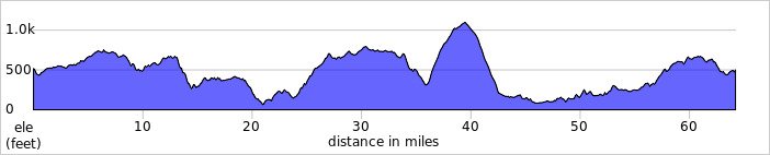
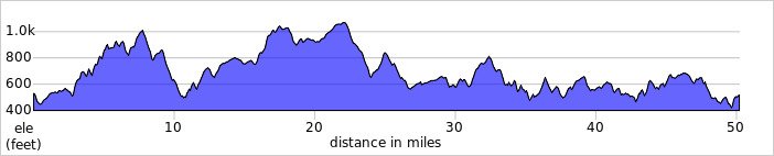
I probably should have taken it easy today but just 8 miles in I had already climbed 1000ft...😂 It was way colder than yesterday despite the forecast showing 6C like yesterday, I even had sunshine for most of my ride but it didn't seem to make any difference to the temp! Just 2 miles into my ride I started the first big climb from Plains up past the Blackhill transmitters near Kirk of Shotts!

1765908544916.jpeg

Its just climb after climb!

1765908567720.jpeg

1765908578400.jpeg

1765908590165.jpeg

1765908605149.jpeg

I finally had a nice descent down to the main road where the climbing started again up past Kirk of Shotts church, then came the awesome descent down into Hartwood! I was a little worried about this one because there was a big flood at the bottom of the hill recently, thankfully it was fine today! From Hartwood I turned east towards Shotts which meant yet more climbing with a couple of descents thrown in! From Shotts I joined the main A71 for a short time before taking the back road up to Climpy, another big climb...

1765909052891.jpeg

Then the big descent down into Forth, lovely smooth tarmac makes this one a real gem to ride!

1765909082322.jpeg

Just before the descent I stopped for a short break and a snack and was surprised to see some frost in the field just after 1pm! Proof that it was colder than the forecast was saying...

1765909147795.jpeg

Looking back up the hill!

1765909285782.jpeg

I had a nice view of the Pentland Hills way in the distance at Forth!

1765909463305.jpeg

From Forth I turned north towards Whitburn and I now had a nice 15mph tailwind helping me up the climb to almost 1100ft, then I had the awesome descent down into Breich to enjoy!

1765909638403.jpeg

Just over 41mph down this one, its not the smoothest road but still a real blast and its very undulating! I had many fun motorbike rides here in the past, taking those undulations at high speed was so much fun!:D I continued north towards Longridge, where I stopped for a couple of photos at Valley View Steading!

1765910117242.jpeg

1765910137757.jpeg

After the big climb up through Longridge I enjoyed the descent down into Whitburn, I was hoping to continue north here but a road closure had me turning west instead! So I joined the cycle path towards Harthill and turned north towards Blackridge, then I continued north up over the climb at Heights!

I grabbed a few photos at the top of the climb before hurtling down the big descent!

1765910435058.jpeg

1765910448701.jpeg

1765910460490.jpeg

Then it was another big climb followed by this amazing descent!

1765910577165.jpeg

I stopped at the bottom for a couple of photos before joining the back road to Slamannan!

1765910631485.jpeg

1765910643681.jpeg

Another few photos before the next climb!

1765910681779.jpeg

1765910758170.jpeg

1765910768755.jpeg

Part way up the climb, looking back down the hill!

1765910807071.jpeg

At Slamannan I took the back road towards Longriggend but I turned off when I spotted some new tarmac on a little back road that joins the main road towards Greengairs instead! I took another back road to add a couple of miles to my ride to make the 50 miles, its a nice twisty and undulating road that ends with a big climb up to Greengairs!

I grabbed a couple of photos on the way up the climb!

1765911367813.jpeg

1765911379335.jpeg

From Greengairs I turned south over the back roads to home and caught the sun setting behind some cloud!

1765911453494.jpeg

Another fantastic and very hilly ride, with bad weather forecast for the rest of the week its time for some rest now!
 

Attachments

  • elevation_profile458.jpg
    elevation_profile458.jpg
    23.2 KB · Views: 2
  • trip-356620070-map-full458.png
    trip-356620070-map-full458.png
    519.5 KB · Views: 2
I rode around Heswall which is the leftovers of a Victorian riverside town, this all used to be white beaches, but nature has reclaimed it
hes1.jpg


All the bridle and byways have become private roads in various states of repair, they are not maintained by the council to tarmac road standards
hes2.jpg


Further up the coast towards Thurtaston the cliffs are eroding very quickly
hes3.jpg


This one cottage right on the miles of beach
hes4.jpg


Retired couple looking over the River Dee to Wales
hes5.jpg


The bread was ludicrously thick at the cycling cafe.
hes6.jpg


Im sure that speed sign is designed to attract attention ,quite a clever trick
hes7.jpg


Beautiful churches and halls.
hes8.jpg


I rode through the common, it does show the paths as public rights of way, but there was no one there anyway.
hes9.jpg


A very challenging ride to the top over wet roots
hes10.jpg


Gorgeous 360 view with North Wales in the distance.
hes11.jpg


This strange outcrop in the centre is called Thors Stone, Thurstaston" comes from Old Norse/English for "Thorsteinn's farm/village, The area was part of a 10th/11th-century Norse settlement, with a Viking village (Straumby)
hes12.jpg


Moggy Minor behind a tiny Toyota Ago
hes13.jpg


No caption
hes14.jpg


Thats quite old I suppose
hes15.jpg


I know this pub, on sunny weekends it is completely rammed and chaotic and the trafficis gridlocked, people buy pints for car passengers, which is actually completely legal in the UK.
hes16.jpg
 
Back