You are using an out of date browser. It may not display this or other websites correctly.
You should upgrade or use an alternative browser.
You should upgrade or use an alternative browser.
2025 - Our Rides in Words, Photos, Maps and Videos
- Thread starter Saratoga Dave
- Start date


RabH
Well-Known Member
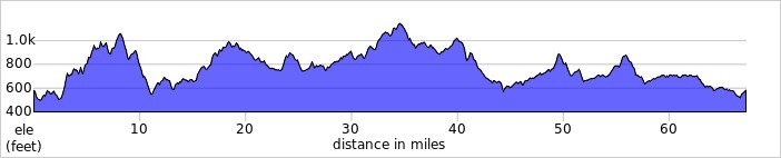
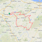
I was hoping to get out yesterday but I woke with a very annoying head cold, my nose was running like a leaky tap! When I woke this morning I was feeling way better, close to 100% so I had to get out! We have already had our first frost which is unusal for September, this morning I went for a drive and had a really nice walk! The temp was finally in double figures near to midday so I set off at 11.45am without any real plan, the wind was a westerly and around 20mph so i decided to enjoy a tailwind to get myself warmed up! One of my local back roads has been closed for almost 2 years and I discovered it was open again so I had to check it out, of course its a big climb!
 It joins the back road past the Blackhill transmitters which is another big climb, in fact just 8 miles into my ride I had already climbed 1000ft which helped to keep me warm on a chilly day!
I grabbed a few photos of course, firstly Roughrigg Reservoir!
The climb up past the transmitters!
Near the top of the climb looking north with the Campsie Hills in the background!
The final climb before a nice descent which was very welcome!
Of course after the descent it was straight back into a big climb up to Kirk of Shotts and then a cracking long descent down into Allanton, surprisingly the road was completely dry which is very unusual! From Allanton I took the back road to Carluke and then Yieldshields where I had a nice view of the Pentland Hills way in the distance!
The road from Yieldshields to Carnwath is just amazing and mostly downhill!
The main herd of Alpacas were in a field out of sight but the 4 troublemakers were still camped in the field next to the road!
")
After passing the Alpacas I had another big climb before the big descent down to Carnwath, I had some nice views of the hills all the way!
The final descent down into Carnwath with Tinto Hill in the background!
At Carnwath I joined the awesome A70 NE towards Tarbrax, its just amazing all the way with climbs and descents and twists and turns that just make you grin from ear to ear and I had a 20mph tailwind making it even more fun today!
I left the A70 to take the back road to Auchengray, another cracking road with more nice views of the hills!
The road into the village of Polkelly, population around 10 I would think!
From there I headed north through Woolfords, which starts with a big climb and then flattens out here!
Then the fastest descent of the day, just under 42mph and the road keeps going down for almost 3 miles with a couple of small climbs thrown in! At the end of the road I turned east for West Calder, 44 miles in and it was time to turn directly into the 20mph headwind! I really picked the best route to enjoy the wind today, now I would have over 20 miles of a chilly headwind! I passed through Addiewell and Stoneyburn before tackling the big climb up through Longridge! Then a nice descent down into Whitburn where I joined the cycle path west to Harthill, after passing through the village I took the back road to Blackridge which meant doubling back on myself but I had a tailwind again for a couple of miles! I also had a nice view of the Ochil Hills to the north!
I arrived in Blackridge at 58 miles and turned west for home with 9 miles remaining! I was going to add 3 miles to bring my mileage to 70 but my 67 miles brought my yearly total to a nice round 5500 miles! I need 1061 miles now to equal my 6561 from last year, so I may well break my record this year all going well! What a fantastic ride in nice conditions, all of the climbing kept me nice and toasty in the chilly wind!
@Chazmo I won't be doing any racing anytime soon, especially not on gravel...
I love my long rides and going fast but racing isn't for me, I will leave that to Stefan!Attachments
Jeremy McCreary
Bought it anyway
- Region
- USA
- City
- Carlsbad, CA
The bike shot really makes me really want to be there.A few pics from today's 23km ride:
View attachment 199843View attachment 199844View attachment 199845View attachment 199846View attachment 199847


Mulezen
Well-Known Member
On my ride yesterday I stopped at Serenity Knoll farm. Beautiful soy beans...DJT's tariffs make them a losing proposition this year. IDK about the price of cactus.

After the ride I sat in the back of my barn icing my knee. I sensed something out of place and snapped this photo. Find the hawk staring at my distant bird feeders.

After the ride I sat in the back of my barn icing my knee. I sensed something out of place and snapped this photo. Find the hawk staring at my distant bird feeders.
Nvreloader
Western Nevada
- Region
- USA
I see something other than the hawk.......
Chargeride
Well-Known Member
Aride today alongside the estuary edge to Cartmel and Grange le Sands, this was so beautiful and completely empty in every direction

It led to a gorgeous farmhouse in the woods next to the water

Just a stream of idyllic farmhouse full hamlets, probably change hands for 500K each.

Totally random vintage sign celebrating a modest climb

The bridleway was mud and leaves, the fat tyres love to collect it.

This wasthe entrance to the bridle way that crosses the high point at 600 ft, you ride through a collection of simply delicious little farmhouses

Magical path climbs to the top.

This is NW England just before the mountains of Cumbria start

Thats a face you would expect to see on a pirate ship.

This is exactly what the Range Rover was designed for, a quick nip down from the lodge to check the gamekeeper wasnt in the pub.

They don't make them like that any more.

This car had just rolled over a 30 ft cliff, his wife left the handbrake off, pretty well written off, the front wheel was bent inwards

I tried to get around Henrys Head as shortcut, but no chance

The other way was closed, but I tried it anyway, this was very nerve wracking, my feet were already going completely under ever turn and it got even worse

This is what it looked like when starting, farmers in 4X4s were turning back.

I got back with 1 mile left on the screen, absolutely filthy, knackered and wet..great day out.

It led to a gorgeous farmhouse in the woods next to the water
Just a stream of idyllic farmhouse full hamlets, probably change hands for 500K each.
Totally random vintage sign celebrating a modest climb
The bridleway was mud and leaves, the fat tyres love to collect it.
This wasthe entrance to the bridle way that crosses the high point at 600 ft, you ride through a collection of simply delicious little farmhouses
Magical path climbs to the top.
This is NW England just before the mountains of Cumbria start
Thats a face you would expect to see on a pirate ship.
This is exactly what the Range Rover was designed for, a quick nip down from the lodge to check the gamekeeper wasnt in the pub.
They don't make them like that any more.
This car had just rolled over a 30 ft cliff, his wife left the handbrake off, pretty well written off, the front wheel was bent inwards
I tried to get around Henrys Head as shortcut, but no chance
The other way was closed, but I tried it anyway, this was very nerve wracking, my feet were already going completely under ever turn and it got even worse
This is what it looked like when starting, farmers in 4X4s were turning back.
I got back with 1 mile left on the screen, absolutely filthy, knackered and wet..great day out.
edobici_forza
Well-Known Member
- Region
- USA
- City
- San Mateo, CA
What a great area! Fun photos! How deep was that water?... it looks to be as high as the tires. How long of a ride?Aride today alongside the estuary edge to Cartmel and Grange le Sands, this was so beautiful and completely empty in every direction
edobici_forza
Well-Known Member
- Region
- USA
- City
- San Mateo, CA
I tried to get out earlier knowing it would be very hot, but was delayed, so it was in the mid-90s, though my Garmin1040 recorded 104° F (which I don't believe). It has been a while, but this was the first time to take obligatory photos of the Creo, at the Pulgas Water Temple, as I do with each bike. EDIT: watching the news tonight, I see that RWCity hit 99° so maybe it was 100°+ out on the pavement!!


Last edited:
Mulezen
Well-Known Member
that ‘other‘ is one of 3 from certified ‘Dominion seeds’ Virginia certified. we’ll soon see…I see something other than the hawk.......
Broad-winged hawk I believe Though there is a red-breasted hawk in a big oak near where the Mexican has/had his chickens. Both kinds of hawks with stubby wings are built for pursuit into a forest. I watched them from my deck fly at speed into my woods. On the oak where the hawk roosts I’ve posted Ted Hughes fine poem “Hawk Roosting”.
Jeremy McCreary
Bought it anyway
- Region
- USA
- City
- Carlsbad, CA
I see you're a Doobie Brothers follower — or at least a fault follower.I tried to get out earlier knowing it would be very hot, but was delayed, so it was in the mid-90s, though my Garmin1040 recorded 104° F (which I don't believe). It has been a while, but this was the first time to take obligatory photos of the Creo, at the Pulgas Water Temple, as I do with each bike.View attachment 199924View attachment 199925View attachment 199926View attachment 199927
Beautiful area around the temple. Handy to have a temple around, in case you need to hit the gods up for a favor.
We have an oddly temple-like Bataquitos Lagoon overlook about a mile from home. Wonderful place to chill on a beautiful day. Ask the gods of cycling for a range extender every time I go by, but nada so far.
;^}
Jeremy McCreary
Bought it anyway
- Region
- USA
- City
- Carlsbad, CA
Forgot to mention that we also have a fault — though not quite the household name yours is. The Rose Canyon Newport Inglewood Fault, a major San Andreas helper, runs ~5 km offshore here.
A rupture of the entire length at once could produce an M7.5 quake. Hate it when that happens!
A rupture of the entire length at once could produce an M7.5 quake. Hate it when that happens!
edobici_forza
Well-Known Member
- Region
- USA
- City
- San Mateo, CA
Yeah, yesterday, our M4.2 quake was not on the San Andreas, but the Hayward Fault, centered in Berkeley! I like the Doobie Bros a bit, but a little early for me...never heard that song.Forgot to mention that we also have a fault — though not quite the household name yours is. The Rose Canyon Newport Inglewood Fault, a major San Andreas helper, runs ~5 km offshore here.
A rupture of the entire length at once could produce an M7.5 quake. Hate it when that happens!
Chargeride
Well-Known Member
The first time heard the term the San Andreas fault, I actually just recieved it as some far away American thing and it had been discovered by two guys called San and Drayus.
It was a long time before I connected the dots.
It was a long time before I connected the dots.
Watana Bob
Well-Known Member
- Region
- USA
Sorry but they have been too busy fixing rashesAsk the gods of cycling for a range extender every time I go by, but nada so far

Watana Bob
Well-Known Member
- Region
- USA
I was 7 years old in ‘64 when the 9.2 hit Alaska and I can still vividly see from memory 60 foot tall spruce tree tops slapping the ground before rebounding during the violent shaking. Big quakes are a real thrill ride that I can live without.
Chazmo
fat-tire biker
- Region
- USA
- City
- Central Massachusetts
Wow. I can’t imagine what that was like.I was 7 years old in ‘64 when the 9.2 hit Alaska and I can still vividly see from memory 60 foot tall spruce tree tops slapping the ground before rebounding during the violent shaking. Big quakes are a real thrill ride that I can live without.
If it’s any consolation, Bob, it seems every region in the US has its “nature livability" issues… I don’t know when the last time a serious quake hit the New England area, but I know that surviving our winters has its own set of remarkable challenges. A few years back we had an ice storm that broke many of the trees/branches around here and made the place sound like a war zone through the night while it was occurring. Having 60-70’ pines, oaks, and maples dropping like every 60 seconds or so was crazy! There was about 1/4-inch (maybe slightly more) of ice coating everything. It was quite the disaster. In the middle of the night, I took my family and ran to a neighbor’s house that wasn’t covered by trees. That was darn stupid as we could’ve been hurt (more) just making the run as branches were falling all around us. Oh well. Other neighbors had a ton of damage, and we were out of power for quite a while as roads were unpassable.
And, then of course down in the southeast you have ridiculous heat (not to mention hurricanes)… You can’t really win.
I guess I’ve “decided” that living in the northeast is preferable for me, but you can’t mess with mother nature!
Chargeride
Well-Known Member
You might try that lovely little area called Old England
stompandgo
Well-Known Member
- Region
- USA
In 2011, we had an EF-3/EF-4 tornado that tore through downtown Springfield, MA. It destroyed my kid's school, and ripped a path of home destruction for about 10 miles east of the city. That same year, Hurricane Irene blew through western MA causing rivers to overflow and wipe out roads and bridges. Power was out for weeks up in the hills. Both of those events were not even close to the coastline, where I live now.
Mulezen
Well-Known Member
The Mineral Virginia 5.9 quake ten years ago or so was felt in 3 countries. I live about ten or so miles from the epicenter (crow fly) and lost some dishes. Millions of $ in damage in DC 100 miles to the north. Geology in East US is not the fractured pieces of the west coast and the power transmits…church bells were rung by it in Boston. The roots (faults) of the occasional tremors we get derives from a meteor strike that carved out the Chesapeake Bay millions of years ago.
Similar threads
- Replies
- 1K
- Views
- 100K
- Replies
- 2K
- Views
- 440K
- Replies
- 2K
- Views
- 526K
- Replies
- 18
- Views
- 7K
- Replies
- 1
- Views
- 8K