Apps for cycling. Does anyone else find them kind of... lacking?

dynamic

Well-Known Member
Region
USA
As I get ready for this new exciting journey of family e-biking, I have been looking at apps. I started a trial of strava as well as ride with gps. And I have taken quick looks at half a dozen others.
As a newly minted family biker, my primary goal is to get the 4 of us from point a to point b, do something family related and return. These destinations are anywhere between 1 and 5 miles currently. Segments, leaderboards, extensive tracking are all perhaps fun, but not strictly necessary.
In my head, I wanted a way to say, "hey, get me from point a to b" and then give it some guides, like "stay off the 15-20% graded hill". And keep to paved roads. In reality, it seems like I have to draw my route.
This is where strava's mobile app just fell apart. I could find no way to edit/cut/splice a route. The only path was undo and redraw. The strava web app has control points you can create and drag. Ride with gps worked ok on both app and web. Hopefully I just missed something. But neither of them did any parameter based routing for destinations that I could find. So I would end up putting a dot at the beginning, a dot at the end and then just pulling the route away from the (direct) bad hills.
So, am I missing something? In this day and age I can't say "map me a nice scenic ride of 3-5 miles that gets me to X while avoiding the uber hills?". That's not a thing yet?
I won't have the e-bikes to try them until next week. So I can't put any of these on bike yet. But, as a software engineer, I am a bit surprised at the state of ride mapping.
Anyone have any suggestions? Are there great apps I haven't tried? Or do I just need to suck it up and deal with one of these two?
 
I do not use any apps for tracking (Strava, RidewithGPS, Sports-Tracker, etc.) as tracking is handled by my Specialized Mission Control app. However, in looking for routes, I use OSMAnd+ with overlays, cycle maps, etc etc to map out routes. OSMAnd is free, the paid version (+) has many more features including downloading maps for offline use.

Not saying it's the greatest planner in the world, but it WORKSFORME; is open source; maps are crowd-sourced and can be edited.
 
apple maps can do that my bosch nyon can though its not great at it. I usually use ride by gps and it can be a challenge to change the route for sure.
 
Does the specialized one run on the bike? Or do you also run your phone next to it?

I ended up with a pair of priority currents largely because the pair cost the same as a single vado 5.0 igh. I wanted to see all that specialized technology though.
 
apple maps can do that my bosch nyon can though its not great at it. I usually use ride by gps and it can be a challenge to change the route for sure.
I just tried the apple maps “avoid hills” option and it still took me down the 18% grade. Cool to know that exists. Too bad it doesn’t work better.
 
I just tried the apple maps “avoid hills” option and it still took me down the 18% grade. Cool to know that exists. Too bad it doesn’t work better.
I bet its only for going up hills. whats wrong with going down a 18% grade? I do that all the time.
 
I bet its only for going up hills. whats wrong with going down a 18% grade? I do that all the time.
Up, it always does the same route regardless of the status of the box (which technically avoids this exact hill by doing a caddy corner around it, but it's still really high grades)
This particularly hill is pretty intense. My wife isn't comfortable and we both avoid it in the car in the winter. Up or Down. Neither of us are bikers currently, and will avoid any stuff like this for a while.
There also is not really any reason to take this street unless the shortest route is the most important thing. Based on my experiencing renting the vado, I am not sure either of us could get up this street even on electric bikes. Let alone hauling two kids. Down just seems like testing your brakes.
ya I can see that. it takes experence and practice to get conferable. I sure freaked my bind wife out going down them on the back of our tandem at first.
 
I do not use any apps for tracking (Strava, RidewithGPS, Sports-Tracker, etc.) as tracking is handled by my Specialized Mission Control app. However, in looking for routes, I use OSMAnd+ with overlays, cycle maps, etc etc to map out routes. OSMAnd is free, the paid version (+) has many more features including downloading maps for offline use.

Not saying it's the greatest planner in the world, but it WORKSFORME; is open source; maps are crowd-sourced and can be edited.
So, OSMAnd hill avoidance actually avoids the hill I want to avoid. Very neat. Not sure how it will do from a tracking the ride perspective. but it definitely got the others beat in route planning.
 
So, am I missing something? In this day and age I can't say "map me a nice scenic ride of 3-5 miles that gets me to X while avoiding the uber hills?". That's not a thing yet?
I won't have the e-bikes to try them until next week. So I can't put any of these on bike yet. But, as a software engineer, I am a bit surprised at the state of ride mapping.
Anyone have any suggestions? Are there great apps I haven't tried? Or do I just need to suck it up and deal with one of these two?
I use water protein apps, aka my wife and her friends. :)

They know all the trails. Once I get familiar with the trails and start to explore, I'll start using apps with GPS coordinates. For now though, I just trust the folks I know. A few are extremely talented riders and luckily, they know my limits. Years ago, my wife and her friends would take me on what they called "easy" rides, which were actually brutal and not fun (too steep and too technical). It's different now that I have an ebike, as long as it's not too technical. But, I'll improve over time.

It might be worth developing an app, if you have the talent. All you'd need to do is extract the trail profile and create a filter to avoid anything steeper than "X" grade. Or have a note stating 18% grade for 0.2 miles, for example.
I just want to get from my house to a playground, community pool, or school so the kids can play and we get some exercise. Maybe go out to eat. Not even concerned with trails. While, technically, I could build something simple to solve this, it's really the data that is valuable. Map data is hard. As evidenced by this hill being shown as anything from 6 to 19% grade in different programs.
My thing, is I doubt I will ever do the exact same route twice. These are doing stuff with kids + errands kinds of trips. Go to the pool, pickup a few essentials on the way home. Drop the kids off at a friends, take the bikes on a date night. Drop off the kid at camp and swing by the bank to get cash. Etc. Most of the time will not be "let's see what kind of scenic route we can find".
It's not like I won't get used to it without routing anything. But currently, even where I live, or anytime I head toward a new area I don't know from a biking perspective, it would be nice to have a trustworthy app to keep you off the silly roads.
Ah well. I think strava will probably win out from the tracking/social side of things. Since no one really actually does this *well*.
OK. I understand. Close friends of our have two young girls. The youngest is too young but can sit on a trailercycle and pedal, which they are buying soon and then all will have bikes. So, the rides will be simple just like you describe. Park at X. Ride to Y, get an ice cream, ride back. Stuff like that.
 
As I get ready for this new exciting journey of family e-biking, I have been looking at apps. I started a trial of strava as well as ride with gps. And I have taken quick looks at half a dozen others.
As a newly minted family biker, my primary goal is to get the 4 of us from point a to point b, do something family related and return. These destinations are anywhere between 1 and 5 miles currently. Segments, leaderboards, extensive tracking are all perhaps fun, but not strictly necessary.
In my head, I wanted a way to say, "hey, get me from point a to b" and then give it some guides, like "stay off the 15-20% graded hill". And keep to paved roads. In reality, it seems like I have to draw my route.
This is where strava's mobile app just fell apart. I could find no way to edit/cut/splice a route. The only path was undo and redraw. The strava web app has control points you can create and drag. Ride with gps worked ok on both app and web. Hopefully I just missed something. But neither of them did any parameter based routing for destinations that I could find. So I would end up putting a dot at the beginning, a dot at the end and then just pulling the route away from the (direct) bad hills.
So, am I missing something? In this day and age I can't say "map me a nice scenic ride of 3-5 miles that gets me to X while avoiding the uber hills?". That's not a thing yet?
I won't have the e-bikes to try them until next week. So I can't put any of these on bike yet. But, as a software engineer, I am a bit surprised at the state of ride mapping.
Anyone have any suggestions? Are there great apps I haven't tried? Or do I just need to suck it up and deal with one of these two?
Once you get on your bike and ride you will find 1-5 miles becomes 10-15, then 5-15 miles becomes 20-30 miles.
Personally, I can barely remember any ride less than 5 miles. I always try to find the longest route to and fro.
No hill is too high, no road is too long, no wind is too strong!
That is the fun of e-biking!
FYI, I use my hiking app: AllTrails to track and record all of my rides.
 
OK. I understand. Close friends of our have two young girls. The youngest is too young but can sit on a trailercycle and pedal, which they are buying soon and then all will have bikes. So, the rides will be simple just like you describe. Park at X. Ride to Y, get an ice cream, ride back. Stuff like that.
Exactly. My eight year old still hasn't learned to ride. So we got a weehoo trailer coming for him, and a rackmount toddler seat for the 2 year old. My original hope was to get them both on one bike. But, the only cargo bike I even remotely liked (tern GSD) cost close to two vados once equipped. So we opted for the one per bike option for a lot less money.
I am hoping the eight year old will see how fun this is and motivate himself to learn more quickly. He is one of those timid kids that gets deflated when he isn't instantly good at something ( and he is generally instantly good at non-physical things). Even then, I doubt he could handle the hill climb to the house anytime soon. Hopefully tow ropes work for him when that starts happening.
 
Last edited:
Once you get on your bike and ride you will find 1-5 miles becomes 10-15, then 5-15 miles becomes 20-30 miles.
Personally, I can barely remember any ride less than 5 miles. I always try to find the longest route to and fro.
No hill is too high, no road is too long, no wind is too strong!
That is the fun of e-biking!
FYI, I use my hiking app: AllTrails to track and record all of my rides.
Perhaps. But the primary motivation is moving kids with an active lifestyle. Where we live there simply isn't anything outside of 5 miles that we would go to. And I am guessing a big circle that lands us where we started will not go over well for the kids. Plus, I suspect the priority current battery will have a say in that. My toddlers daycare is 6.2 miles away, and I am thinking of running him out there by bike. But they won't be staying there after july. And I think the new location will be way harder to get to. Six miles one way is probably getting out of available time to do such things by bike. At least one of those directions will be one hell of a ride for me. We shall see!
 
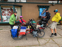
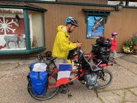
Maybe if you do enough rides with the family, you'll build up to something like this couple I met in the Tetons. They were from France and decided to do a 6 month bike ride from Canada to South America. I think they said Argentina was their destination - can't remember. They stopped to get supplies and would ride for three weeks between stops for food and supplies. At this point, they were averaging about 60 miles per day.
 

Attachments

  • IMG_7148.jpeg
    IMG_7148.jpeg
    936.8 KB · Views: 171
  • IMG_7147.jpeg
    IMG_7147.jpeg
    857.5 KB · Views: 177
Does the specialized one run on the bike? Or do you also run your phone next to it?

I ended up with a pair of priority currents largely because the pair cost the same as a single vado 5.0 igh. I wanted to see all that specialized technology though.
Specialized's Mission Control app runs on your phone, and it connects via BT to the Specialized TCDw (display). It only works for their bikes. Basic but for tuning the bike and doing simple tracking, it's fine.
 
Maybe if you do enough rides with the family, you'll build up to something like this couple I met in the Tetons. They were from France and decided to do a 6 month bike ride from Canada to South America. I think they said Argentina was their destination - can't remember. They stopped to get supplies and would ride for three weeks between stops for food and supplies. At this point, they were averaging about 60 miles per day.
Maybe if I sold my house and we quit our jobs!
I doubt the bike can work year round here either. I just don’t see rain or snow as real options for riding. I am currently planning on getting studded tires, but that is almost certainly for nicer days no matter what. I hope I can continue through some of winter.
 
So, OSMAnd hill avoidance actually avoids the hill I want to avoid. Very neat. Not sure how it will do from a tracking the ride perspective. but it definitely got the others beat in route planning.
Really depends on what you want to track? I only log the basics: distance, speed, elevation +/-, the actual route. If it's a route I really like, I'll export the gpx (and can import it to Mission Control).

I used to use Sports-Tracker for hiking and found it was great for my needs, and I liked the ethos of the company (based in EU, so GDPR was a huge plus). But then one day, I realized I didn't care at all about competing with others, social, etc etc. I've become very anti-tracking, esp when it comes to personal health data - it'd be nice to have I suppose, but if I can't keep it local to my device, not interested (looking at Google, Apple, and all the others who use or sell our data; and the risk of all of these app devs getting hacked).
 
So, OSMAnd hill avoidance actually avoids the hill I want to avoid. Very neat. Not sure how it will do from a tracking the ride perspective. but it definitely got the others beat in route planning.
OSMand for Android cycling mode has four different riding style (driving style) settings and three hill "avoidance" (elevation) settings. For example, for my route planning default, I use "Prefer Byways" and "Less Hilly". I store that and other option combinations as Cycling presets.

Have also added BRouter as a navigation plugin for an additional cycle routing option.

As far as tracking goes. OSMand records your trip (various detail/accuracy options) and the resultant GPX file can be imported into other apps or services like Strava. Live tracking can also be done via a Telegram plugin or directly to your own web site. I've used the latter for years

All the above work very well for me. It is my default cycle route planning and trip recording app. Now and again I've tested other apps to ensure it continues to be the best option for me. This testing also includes priority use of cycle paths.

I don't use the iOS version of OSMand but I understand the developers have been putting a lot of effort into feature catch-up so that its feature set is on a par with the Android version.

Good luck with your choice.

Peter
 
Last edited:
Back