Bike related Christmas gifts

I got my better half an Endura Primaloft jacket to keep her warm on spring and late fall rides. And who doesn’t want socks for Xmas?

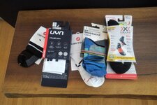
IMG_20221223_1103435.jpg
 
I got an ultra-sonic bath cleaner for Christmas this year. No excuse for dirty chains, cassettes and other stuff now - and they're going to get dirty,
We're back to riding weather but it's going to be sloppy. Winter wheels back on (love the 2nd set of wheels - 3 minutes to swap both).
 
Really hope the family comes through on the Amazon wish list I loaded up with yet more stuff for my new Vado SL. This bike's already cost me a fortune in just 3 months, my wife's patience is long gone, and of course, the important work of acquiring ever more bike stuff is never done.

Among other things, the list includes a Park Tool home work stand, a digital tire gauge, and some high-vis cycling sox. Showed some restraint in not asking for $1200 aero sox.

Not on the list is the Wahoo I think @Stefan Mikes might be getting me.
;^}

One big SL expense I didn't see coming: Replacing all my pants and regular shorts after the bike made me lose 2 inches in the waist. Wife likes the result but still counts it as wanton bike spending.
 
Last edited:
Nice! Is it accurate? Where can I get one?

Would love to know the true grades of my local hills. Have good reason to believe (a) that RideWithGPS underestimates grades, and (b) that the On the Go Map app overestimates — both with significant error.

Maybe I could carry this inclinometer long enough to establish a reliable correction factor — say, a multiplier of 1.2 to correct a RideWithGPS grade of 10% to a true 12%.
 
Blips Grips. They are clear grips with led lights inside. $40. I ordered a set (will add photos later) but the grips are BRIGHT! They have multiple colors, patterns, brightness control and effect speed control. I was going to put them on my JackRabbit but my wife claimed them for the passenger bars on the Xpedition. Anyways, look up Blips Grips. They would even be good for a kids bike. I also discovered they (grips) use the same remote as my Floval color light on my fist tank!
 
I have one of these and it works well. The only problem is, keeping it in alignment on the handlebars. Due to the angle of the stem, the gauge reading varies as you turn the bars. When going around curves, it can also give a false reading due to the slight lean of the bike Depending on the type & shape of your bars, the reading can vary quite a bit on a long slow curve.

I'm looking for a way to mount it on the stem cap. This would eliminate part of the error.

Either way, it's still a handy little device, and more accurate than a short term GPS grade display that calculates average elevation change over distance.
 
Nice! Is it accurate? Where can I get one?

Would love to know the true grades of my local hills. Have good reason to believe (a) that RideWithGPS underestimates grades, and (b) that the On the Go Map app overestimates — both with significant error.

Maybe I could carry this inclinometer long enough to establish a reliable correction factor — say, a multiplier of 1.2 to correct a RideWithGPS grade of 10% to a true 12%.
Jeremy, I don't want make you irritated but did you know Wahoo activated the Summit mode and gave you the current incline and the feet to go to the summit automatically? :D
Just teasing you!

When we went in high mountains with my brother for the second time, my Wahoo Roam v1 had laughable Climbing features while Garmin Edge 530 of Jacek had the full Climb Pro capability. He gladly informed me how many summits we would have on our Kłodzko Valley trip. As we were approaching steep ascents, he always was in the front and was raising his hands to indicate the current grade with his fingers :D Once, he rose both his hands to indicate 10% and then rose his right hand again, showing two percent more :D I would rather be happy to remain ignorant! :D

1734445738733.png
 
Last edited:
The problem with many of these apps is, they use either GPS or barometric altimeters to calculate altitude change over distance travelled. Both GPS and barometric altimeters are prone to errors and are useful over the course of a ride but of little value to display real time slope readings. For this, the bubble type instruments are far more accurate.

Bubble instruments are analog though and do not record slope over time or distance. I use both an app for ride recording and a bubble gauge for real time slope readings.
Don't you think a good GPS bike computer reads the data from the map? Wahoo got its Summit feature only after 64 GB RAM was provided for ver 2, which allowed using 3D maps. (Garmin had it well before).

I"m sure these premium devices use the map as either Garmin or Wahoo can tell you anything on the future climbs on the route even before you have started the ride!
Guessing all of these maps rest on clouds of 3D position coordinates. If so, grades are subject to many vagaries, including the lengths of the profile chords used and the chosen interpolation method.

With an analog handlebar inclinometer, the road profile chord length is always the bike's wheelbase, and the interpolation is linear.
 
Last edited:
Guessing all of these maps rest on clouds of 3D position coordinates. If so, grades are subject to many vagaries, including the lengths of the profile chords used and the chosen interpolation method.

With an analog handlebar inclinometer, the road profile chord length is always the bike's wheelbase.
Funny to think commercial airplanes fly without any analog gauges ✈️ 😆
 
Don't you think a good GPS bike computer reads the data from the map? Wahoo got its Summit feature only after 64 GB RAM was provided for ver 2, which allowed using 3D maps. (Garmin had it well before).

I"m sure these premium devices use the map as either Garmin or Wahoo can tell you anything on the future climbs on the route even before you have started the ride!
Yes, this is true with some apps. However, the map data has errors too and isn't precise for every point along your route. The bubble gauge will give you an exact real time readout of the slope on the spot where you are standing. The only error is the calibration of the device itself. It is easy to recalibrate if necessary, using a simple carpenters level.

Keep in mind, we are talking about minute differences. I doubt the error between the digital and analog devices would be noticed by someone riding a bike.
 
Back