No doubt this isn’t rocket science, but likely not as simple as you think. We don’t know, for example, if the bike even transmits that data over the Bluetooth link to the phone. We know it transmits power, cadence, lots of things, but they’re mostly based on semi-standard profiles for bikes and other light electric vehicles. I’m not aware that “altitude gain” is one of those things.
And, of course, if it isn’t already transmitted, to make the change requires tweaking many different bikes with many different types of electronics, and modifying the specialized app to know whether to use that data (if the bike has been updated) or the phone’s sensors (if the bike hasn’t.)
alternately, specialized can just use the phone data for location, temperature, altitude, etc, and hope that over the years and across different devices apple, Samsung, Sony, etc will improve their elevation accuracy. (For free…)
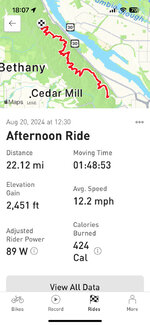
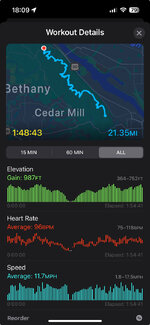
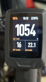
a more interesting question is why your altitude data is SO far off on the phone. Between the various apps, computers, bikes, services, etc I’ve used, I’ve not seen such a huge discrepancy. the data is definitely not good, but it’s also not THAT bad.
what kind of phone are you using, what version of the operating system, is it on the handlebars, what settings do you have on location services, etc?
")